Bridge Statistics for Grinnell, Kansas (KS)
Condition, Traffic, Stress, Structural Evaluation, Project Costs
- National Bridge Inventory (NBI) Statistics
- 11Number of bridges
- 108ft / 32.8mTotal length
- 26,024Total average daily traffic
- 7,773Total average daily truck traffic
- National Bridge Inventory (NBI) Registered Bridges for Grinnell
- No street view available for this location
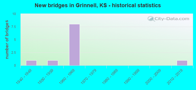
- New bridges - historical statistics
- 11940-1949
- 11950-1959
- 81960-1969
- 12010-2019


- Bridge Condition - Deck
- 50.0%Good
- 50.0%Satisfactory

- Bridge Condition - Superstructure
- 75.0%Good
- 25.0%Satisfactory

- Bridge Condition - Channel
- 20.0%Very good
- 80.0%Good

- Bridge Condition - Culverts
- 75.0%Good
- 25.0%Satisfactory
Find on map >> Show street view
Structure Number: 32022, Location: 1.4S OF GRINNELL (Lat: 39.106511, Lng: -100.627583), Route carried "on" structure: County highway 273, Year Built: 1948, Status: Posted for load, Structure Length: 0.97m (3.18ft), Average Daily Traffic: 320 (year 2014), Truck Traffic: 30%, Average Future Daily Traffic: 330 (year 2040), Design Load: H 20, Features Intersected: TRIB. TO BIG CREEK
Minimum Vertical Clearance: 30.47m (99.97ft), Kilometerpoint: 16.254, Lanes on structure: 2, Owner: County Highway Agency, Approaching Roadway Width: 7.9m (25.9ft), Material/Design: Concrete, Design/Construction: Culvert, Number Of Spans In Main Unit: 3, Length of Maximum Span: 3.0m (9.8ft), Curb-To-Curb Width: 8.1m (26.6ft), Out-to-Out Width: 8.7m (28.5ft)
Condition: Channel: Good, Culverts: Good, Operating Rating: 36.4 metric tons, Method Used To Determine Operating Rating: Load Factor (LF), Inventory Rating: 21.8 metric tons, Method Used To Determine Inventory Rating: Load Factor (LF), Structural Evaluation: Equal to present minimum criteria, Deck Geometry: Somewhat better than minimum adequacy, Waterway Adequacy: Equal to present minimum criteria, Approach Roadway Alignment: Equal to present desirable criteria, Designated Inspection Frequency: Every 24 months, Inspection Date: May 2020, Other Special Inspection Date: Febuary 2020, Wearing Surface/Protective System: Wearing Surface: Gravel
Find on map >> Show street view
Structure Number: 32044, Location: 3.0S of Grinnell (Lat: 39.082931, Lng: -100.628250), Route carried "on" structure: County highway 273, Year Built: 2014, Status: Open, Structure Length: 1.32m (4.33ft), Average Daily Traffic: 290 (year 2014), Truck Traffic: 20%, Average Future Daily Traffic: 300 (year 2040), Design Load: HL 93, Features Intersected: Big Creek
Minimum Vertical Clearance: 30.47m (99.97ft), Kilometerpoint: 0.000, Lanes on structure: 2, Owner: County Highway Agency, Approaching Roadway Width: 8.5m (27.9ft), Material/Design: Concrete, Design/Construction: Culvert, Number Of Spans In Main Unit: 3, Length of Maximum Span: 4.3m (14.1ft)
Condition: Channel: Very good, Culverts: Good, Operating Rating: 61.9 metric tons, Method Used To Determine Operating Rating: Load and Resistance Factor Rating (LRFR) rating reported by rating factor(RF) method using HL-93 loadings, Inventory Rating: 47.6 metric tons, Method Used To Determine Inventory Rating: Load and Resistance Factor Rating (LRFR) rating reported by rating factor(RF) method using HL-93 loadings, Structural Evaluation: Better than present minimum criteria, Waterway Adequacy: Equal to present desirable criteria, Approach Roadway Alignment: Equal to present desirable criteria, Designated Inspection Frequency: Every 24 months, Inspection Date: May 2020, Other Special Inspection Date: June 2021, Wearing Surface/Protective System: Wearing Surface: Gravel
Find on map >> Show street view
Structure Number: 90001, Location: 13.1S 10.0W OF HOXIE (Lat: 39.165500, Lng: -100.627111), Route carried "on" structure: County highway 273, Year Built: 1957, Status: Posted for load, Structure Length: 7.10m (23.29ft), Average Daily Traffic: 160 (year 2014), Truck Traffic: 10%, Average Future Daily Traffic: 180 (year 2040), Design Load: H 15, Features Intersected: SALINE RIVER
Minimum Vertical Clearance: 30.47m (99.97ft), Kilometerpoint: 3.701, Lanes on structure: 2, Owner: County Highway Agency, Approaching Roadway Width: 7.6m (24.9ft), Material/Design: Concrete continuous, Design/Construction: Tee Beam, Number Of Spans In Main Unit: 5, Length of Maximum Span: 15.2m (49.9ft), Curb or Sidewalk Widths: Left: 0.3m (1.0ft), Right: 0.3m (1.0ft), Curb-To-Curb Width: 7.3m (24.0ft), Out-to-Out Width: 7.9m (25.9ft)
Condition: Deck: Satisfactory, Superstructure: Satisfactory, Substructure: Good, Channel: Good, Operating Rating: 29.2 metric tons, Method Used To Determine Operating Rating: Load Factor (LF), Inventory Rating: 17.5 metric tons, Method Used To Determine Inventory Rating: Load Factor (LF), Structural Evaluation: Somewhat better than minimum adequacy, Deck Geometry: Somewhat better than minimum adequacy, Waterway Adequacy: Better than present minimum criteria, Approach Roadway Alignment: Equal to present desirable criteria, Designated Inspection Frequency: Every 24 months, Inspection Date: July 2020, Deck Structure Type: Concrete Cast-file-Place, Wearing Surface/Protective System: Wearing Surface: Monolithic Concrete
Find on map >> Show street view
Structure Number: 32046510424, Location: 1.5S 0.4E OF GRINNELL (Lat: 39.104417, Lng: -100.623669), Route carried "on" structure: County highway , Year Built: 1963, Status: Open, Structure Length: 0.63m (2.07ft), Average Daily Traffic: 30 (year 2014), Average Future Daily Traffic: 35 (year 2041), Design Load: H 15, Features Intersected: TRIB. TO BIG CREEK, Facility Carried by Structure: CC ROAD
Minimum Vertical Clearance: 30.47m (99.97ft), Kilometerpoint: 0.000, Lanes on structure: 2, Owner: County Highway Agency, Approaching Roadway Width: 7.3m (24.0ft), Material/Design: Concrete, Design/Construction: Culvert, Number Of Spans In Main Unit: 2, Length of Maximum Span: 3.0m (9.8ft), Curb-To-Curb Width: 7.8m (25.6ft), Out-to-Out Width: 9.3m (30.5ft)
Condition: Channel: Good, Culverts: Good, Operating Rating: 32.7 metric tons, Method Used To Determine Operating Rating: Field evaluation and documented engineering judgment, Inventory Rating: 32.7 metric tons, Method Used To Determine Inventory Rating: Field evaluation and documented engineering judgment, Structural Evaluation: Better than present minimum criteria, Deck Geometry: Equal to present minimum criteria, Waterway Adequacy: Better than present minimum criteria, Approach Roadway Alignment: Equal to present desirable criteria, Designated Inspection Frequency: Every 24 months, Inspection Date: March 2021, Other Special Inspection Date: June 2021, Wearing Surface/Protective System: Wearing Surface: Gravel
Find on map >> Show street view
Structure Number: 999907000320051, Location: 7.26MI E LOGAN CO LINE (Lat: 39.111389, Lng: -100.683333), Route carried "on" structure: ServiceCounty highway 14, Year Built: 1964, Status: Open, Structure Length: 7.33m (24.05ft), Average Daily Traffic: 21 (year 2020), Average Future Daily Traffic: 8,215 (year 2041), Design Load: H 15, Features Intersected: I70 HWY, Facility Carried by Structure: LOCAL ROAD
Minimum Vertical Clearance: 30.47m (99.97ft), Kilometerpoint: 2.403, Lanes on structure: 2, Lanes under structure: 4, Owner: State Highway Agency, Approaching Roadway Width: 7.3m (24.0ft), Material/Design: Concrete continuous, Design/Construction: Box Beam or Girders - Multiple, Number Of Spans In Main Unit: 4, Length of Maximum Span: 20.7m (67.9ft), Curb-To-Curb Width: 7.6m (24.9ft), Out-to-Out Width: 9.0m (29.5ft)
Condition: Deck: Good, Superstructure: Good, Substructure: Good, Operating Rating: 66.0 metric tons, Method Used To Determine Operating Rating: Load Factor (LF), Inventory Rating: 39.6 metric tons, Method Used To Determine Inventory Rating: Load Factor (LF), Structural Evaluation: Better than present minimum criteria, Deck Geometry: Equal to present minimum criteria, Underclear: Somewhat better than minimum adequacy, Approach Roadway Alignment: Somewhat better than minimum adequacy, Length Of Structure Improvement: 24.05m (78.90ft), Designated Inspection Frequency: Every 24 months, Inspection Date: June 2020, Deck Structure Type: Concrete Cast-file-Place, Wearing Surface/Protective System: Wearing Surface: Monolithic Concrete
Find on map >> Show street view
Structure Number: 999907000320061, Location: 9.77MI E LOGAN CO LINE (Lat: 39.111389, Lng: -100.636667), Route carried "on" structure: Interstate 70, Year Built: 1963, Status: Open, Structure Length: 0.76m (2.49ft), Average Daily Traffic: 6,274 (year 2020), Truck Traffic: 30%, Average Future Daily Traffic: 8,964 (year 2041), Design Load: H 20, Features Intersected: BIG CREEK DRAINAGE
Minimum Vertical Clearance: 30.47m (99.97ft), Kilometerpoint: 15.720, Lanes on structure: 4, Base Highway Network: Yes, Owner: State Highway Agency, Approaching Roadway Width: 12.2m (40.0ft), Skew: 23 degrees, Material/Design: Concrete, Design/Construction: Culvert, Number Of Spans In Main Unit: 2, Length of Maximum Span: 3.7m (12.1ft), Curb-To-Curb Width: 24.4m (80.1ft), Out-to-Out Width: 49.8m (163.4ft)
Condition: Channel: Good, Culverts: Satisfactory, Operating Rating: 50.9 metric tons, Method Used To Determine Operating Rating: Load Factor (LF), Inventory Rating: 30.5 metric tons, Method Used To Determine Inventory Rating: Load Factor (LF), Structural Evaluation: Equal to present minimum criteria, Deck Geometry: Superior to present desirable criteria, Waterway Adequacy: Equal to present desirable criteria, Approach Roadway Alignment: Equal to present desirable criteria, Length Of Structure Improvement: 2.48m (8.14ft), Designated Inspection Frequency: Every 24 months, Inspection Date: June 2020, Deck Structure Type: Concrete Cast-file-Place, Wearing Surface/Protective System: Wearing Surface: Bituminous
Find on map >> Show street view
Structure Number: 999907000320081, Location: 2.94MI E JT K216 (Lat: 39.111389, Lng: -100.572500), Route carried "on" structure: ServiceCounty highway 21, Year Built: 1964, Status: Open, Structure Length: 7.33m (24.05ft), Average Daily Traffic: 21 (year 2020), Average Future Daily Traffic: 7,715 (year 2041), Design Load: H 15, Features Intersected: I70 HWY, EB-WB, Facility Carried by Structure: LOCAL ROAD
Minimum Vertical Clearance: 30.47m (99.97ft), Kilometerpoint: 2.433, Lanes on structure: 2, Lanes under structure: 4, Owner: State Highway Agency, Approaching Roadway Width: 7.3m (24.0ft), Material/Design: Concrete continuous, Design/Construction: Box Beam or Girders - Multiple, Number Of Spans In Main Unit: 4, Length of Maximum Span: 20.7m (67.9ft), Curb-To-Curb Width: 7.6m (24.9ft), Out-to-Out Width: 9.0m (29.5ft)
Condition: Deck: Good, Superstructure: Good, Substructure: Good, Operating Rating: 66.0 metric tons, Method Used To Determine Operating Rating: Load Factor (LF), Inventory Rating: 39.6 metric tons, Method Used To Determine Inventory Rating: Load Factor (LF), Structural Evaluation: Better than present minimum criteria, Deck Geometry: Equal to present minimum criteria, Underclear: Somewhat better than minimum adequacy, Approach Roadway Alignment: Somewhat better than minimum adequacy, Length Of Structure Improvement: 24.05m (78.90ft), Designated Inspection Frequency: Every 24 months, Inspection Date: June 2020, Deck Structure Type: Concrete Cast-file-Place, Wearing Surface/Protective System: Wearing Surface: Monolithic Concrete
Find on map >> Show street view
Structure Number: 999921600320071, Location: JCT K216/I70 (Lat: 39.111389, Lng: -100.627222), Route carried "on" structure: State highway 216, Year Built: 1964, Status: Open, Structure Length: 7.33m (24.05ft), Average Daily Traffic: 850 (year 2020), Truck Traffic: 22%, Average Future Daily Traffic: 1,191 (year 2041), Design Load: H 20, Features Intersected: I70 HWY
Minimum Vertical Clearance: 30.47m (99.97ft), Kilometerpoint: 0.404, Lanes on structure: 2, Lanes under structure: 4, Owner: State Highway Agency, Approaching Roadway Width: 7.3m (24.0ft), Material/Design: Concrete continuous, Design/Construction: Box Beam or Girders - Multiple, Number Of Spans In Main Unit: 4, Length of Maximum Span: 20.7m (67.9ft), Curb-To-Curb Width: 8.5m (27.9ft), Out-to-Out Width: 10.2m (33.5ft)
Condition: Deck: Satisfactory, Superstructure: Good, Substructure: Good, Operating Rating: 71.8 metric tons, Method Used To Determine Operating Rating: Load Factor (LF), Inventory Rating: 43.0 metric tons, Method Used To Determine Inventory Rating: Load Factor (LF), Structural Evaluation: Better than present minimum criteria, Deck Geometry: Somewhat better than minimum adequacy, Underclear: Meets minimum limits, Approach Roadway Alignment: Meets minimum limits, Length Of Structure Improvement: 24.05m (78.90ft), Designated Inspection Frequency: Every 24 months, Inspection Date: June 2020, Deck Structure Type: Concrete Cast-file-Place, Wearing Surface/Protective System: Wearing Surface: Low Slump Concrete
Find on map >> Show street view
Structure Number: 999907000320051, Location: 7.26MI E LOGAN CO LINE (Lat: 39.111389, Lng: -100.683333), Route carried "under" structure: Interstate 70, Year Built: 1964, Structure Length: 0. m, Average Daily Traffic: 6,274 (year 2020), Truck Traffic: 30%, Features Intersected: I70 HWY, Facility Carried by Structure: LOCAL ROAD
Minimum Vertical Clearance: 4.86m (15.94ft), Kilometerpoint: 11.685, Lanes on structure: 2, Lanes under structure: 4, Material/Design: Concrete continuous, Design/Construction: Box Beam or Girders - Multiple, Length of Maximum Span: 20.7m (67.9ft)
Find on map >> Show street view
Structure Number: 999907000320081, Location: 2.94MI E JT K216 (Lat: 39.111389, Lng: -100.572500), Route carried "under" structure: Interstate 70, Year Built: 1964, Structure Length: 0. m, Average Daily Traffic: 5,892 (year 2020), Truck Traffic: 31%, Features Intersected: I70 HWY, EB-WB, Facility Carried by Structure: LOCAL ROAD
Minimum Vertical Clearance: 4.86m (15.94ft), Kilometerpoint: 21.280, Lanes on structure: 2, Lanes under structure: 4, Material/Design: Concrete continuous, Design/Construction: Box Beam or Girders - Multiple, Length of Maximum Span: 20.7m (67.9ft)
Find on map >> Show street view
Structure Number: 999921600320071, Location: JCT K216/I70 (Lat: 39.111389, Lng: -100.627222), Route carried "under" structure: Interstate 70, Year Built: 1964, Structure Length: 0. m, Average Daily Traffic: 5,892 (year 2020), Truck Traffic: 31%, Features Intersected: I70 HWY, Facility Carried by Structure: RS0273, 216 HWY LT
Minimum Vertical Clearance: 4.77m (15.65ft), Kilometerpoint: 16.539, Lanes on structure: 2, Lanes under structure: 4, Material/Design: Concrete continuous, Design/Construction: Box Beam or Girders - Multiple, Length of Maximum Span: 20.7m (67.9ft)