Bridge Statistics for Grosse Ile, Michigan (MI)
Condition, Traffic, Stress, Structural Evaluation, Project Costs
- National Bridge Inventory (NBI) Statistics
- 12Number of bridges
- 207ft / 62.9mTotal length
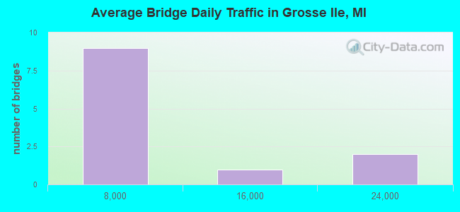
- 67,191Total average daily traffic
- 1,298Total average daily truck traffic
- National Bridge Inventory (NBI) Registered Bridges for Grosse Ile
- No street view available for this location
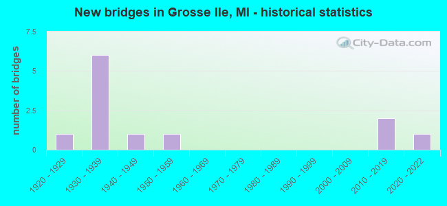
- New bridges - historical statistics
- 11920-1929
- 61930-1939
- 11940-1949
- 11950-1959
- 22010-2019
- 12020-2022
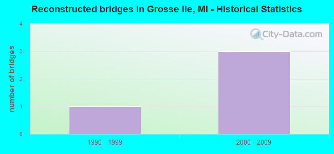
- Reconstructed bridges - Historical Statistics
- 11990-1999
- 32000-2009
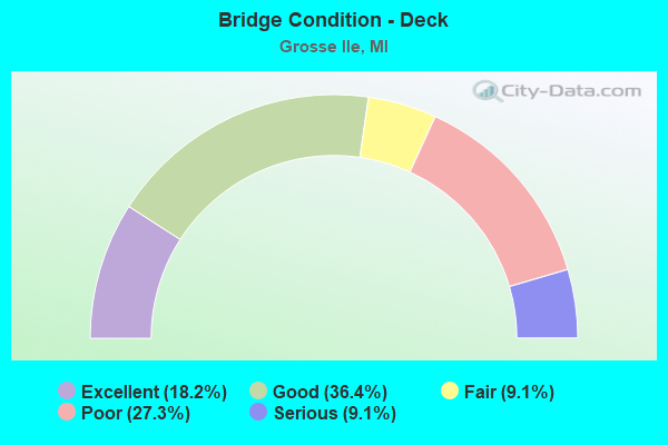
- Bridge Condition - Deck
- 18.2%Excellent
- 36.4%Good
- 9.1%Fair
- 27.3%Poor
- 9.1%Serious
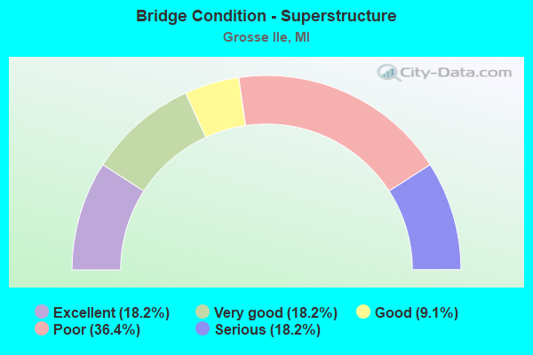
- Bridge Condition - Superstructure
- 18.2%Excellent
- 18.2%Very good
- 9.1%Good
- 36.4%Poor
- 18.2%Serious
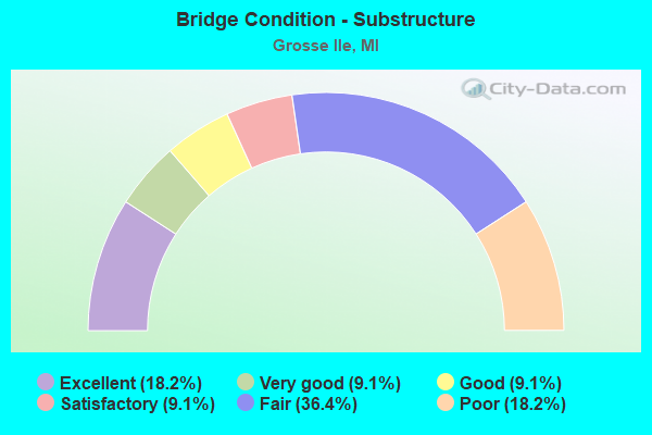
- Bridge Condition - Substructure
- 18.2%Excellent
- 9.1%Very good
- 9.1%Good
- 9.1%Satisfactory
- 36.4%Fair
- 18.2%Poor
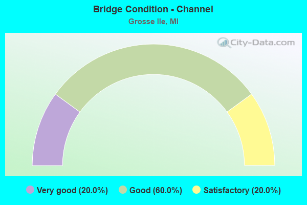
- Bridge Condition - Channel
- 20.0%Very good
- 60.0%Good
- 20.0%Satisfactory
Find on map >> Show street view
Structure Number: 12006, Location: GROSSE ILE (Lat: 42.127303, Lng: -83.173028), Route carried "on" structure: County highway 2057, Year Built: 1932, Year Reconstructed: 2007, Status: Posted for load, Structure Length: 41.02m (134.58ft), Average Daily Traffic: 22,180 (year 2007), Truck Traffic: 2%, Average Future Daily Traffic: 27,060 (year 2027), Design Load: HS 20+Mod, Features Intersected: TRENTON CHANNEL, Facility Carried by Structure: GROSSE ILE PARKWAY
Minimum Vertical Clearance: 30.48m (100.00ft), Kilometerpoint: 1.038, Lanes on structure: 2, Owner: County Highway Agency, Approaching Roadway Width: 12.2m (40.0ft), Navigation Control: Yes ( Vertical Clearance: 0.3m (1.0ft), Horizontal Clearance: 45.7m (149.9ft)), Material/Design: Steel continuous, Design/Construction: Movable - Swing, Number Of Spans In Main Unit: 2, Number Of Approach Spans: 10, Length of Maximum Span: 51.8m (169.9ft), Curb or Sidewalk Widths: Left: 0.7m (2.3ft), Right: 0.7m (2.3ft), Curb-To-Curb Width: 6.1m (20.0ft), Out-to-Out Width: 9.7m (31.8ft)
Condition: Deck: Good, Superstructure: Poor, Substructure: Fair, Channel: Good, Operating Rating: 29.5 metric tons, Method Used To Determine Operating Rating: Load and Resistance Factor Rating (LRFR) rating reported by rating factor(RF) method using HL-93 loadings, Inventory Rating: 22.7 metric tons, Method Used To Determine Inventory Rating: Load and Resistance Factor Rating (LRFR) rating reported by rating factor(RF) method using HL-93 loadings, Structural Evaluation: Meets minimum limits, Deck Geometry: High priority of replacement, Waterway Adequacy: Equal to present desirable criteria, Approach Roadway Alignment: Meets minimum limits, Bridge Posting: Required (Relationship of Operating Rating to Maximum Legal Load: > 39.9% below), Designated Inspection Frequency: Every 8 months, Critical Feature Inspection Frequency: Every 7 months, Underwater Inspection Frequency: Every 10 months, Inspection Date: November 2021, Critical Feature Inspection Date: November 2021, Underwater Inspection Date: November 2021, Deck Structure Type: Open Grating
Find on map >> Show street view
Structure Number: 12007, Location: GROSSE ILE T E/TRENTON CH (Lat: 42.127275, Lng: -83.172225), Route carried "on" structure: County highway 2057, Year Built: 2019, Status: Open, Structure Length: 1.52m (4.99ft), Average Daily Traffic: 21,198 (year 1995), Truck Traffic: 2%, Average Future Daily Traffic: 16,574 (year 2015), Design Load: Greater than HL93, Features Intersected: WEST RIVER ROAD, Facility Carried by Structure: GROSSE ILE PARKWAY
Minimum Vertical Clearance: 30.48m (100.00ft), Kilometerpoint: 1.106, Lanes on structure: 2, Lanes under structure: 2, Owner: County Highway Agency, Approaching Roadway Width: 9.1m (29.9ft), Material/Design: Steel, Design/Construction: Stringer/Multi-beam, Number Of Spans In Main Unit: 1, Length of Maximum Span: 14.2m (46.6ft), Curb or Sidewalk Widths: Left: 2.3m (7.5ft), Right: 2.3m (7.5ft), Curb-To-Curb Width: 8.5m (27.9ft), Out-to-Out Width: 13.1m (43.0ft)
Condition: Deck: Excellent, Superstructure: Excellent, Substructure: Excellent, Operating Rating: 67.7 metric tons, Method Used To Determine Operating Rating: Load and Resistance Factor Rating (LRFR) rating reported by rating factor(RF) method using HL-93 loadings, Inventory Rating: 52.2 metric tons, Method Used To Determine Inventory Rating: Load and Resistance Factor Rating (LRFR) rating reported by rating factor(RF) method using HL-93 loadings, Structural Evaluation: Superior to present desirable criteria, Deck Geometry: High priority of replacement, Underclear: High priority of corrective action, Approach Roadway Alignment: Equal to present desirable criteria, Designated Inspection Frequency: Every 24 months, Inspection Date: Febuary 2021, Deck Structure Type: Concrete Cast-file-Place, Wearing Surface/Protective System: Wearing Surface: Monolithic Concrete
Find on map >> Show street view
Structure Number: 1221, Location: GROSSE ILE N/GROSS I PKWY (Lat: 42.127675, Lng: -83.172175), Route carried "on" structure: County highway 2057, Year Built: 1935, Year Reconstructed: 1995, Status: Open, Structure Length: 2.92m (9.58ft), Average Daily Traffic: 2,803 (year 1995), Truck Traffic: 2%, Average Future Daily Traffic: 2,402 (year 2015), Design Load: HS 20+Mod, Features Intersected: THOROFARE CANAL, Facility Carried by Structure: WEST RIVER ROAD
Minimum Vertical Clearance: 30.48m (100.00ft), Kilometerpoint: 2.187, Lanes on structure: 2, Owner: County Highway Agency, Approaching Roadway Width: 11.0m (36.1ft), Material/Design: Prestressed concrete, Design/Construction: Box Beam or Girders - Multiple, Number Of Spans In Main Unit: 3, Length of Maximum Span: 14.0m (45.9ft), Curb or Sidewalk Widths: Left: 3.0m (9.8ft), Right: 3.0m (9.8ft), Curb-To-Curb Width: 12.2m (40.0ft), Out-to-Out Width: 13.1m (43.0ft)
Condition: Deck: Good, Superstructure: Good, Substructure: Satisfactory, Channel: Good, Operating Rating: 97.2 metric tons, Method Used To Determine Operating Rating: Load Factor (LF) rating reported by rating factor (RF) method using MS18 loading, Inventory Rating: 63.8 metric tons, Method Used To Determine Inventory Rating: Load Factor (LF) rating reported by rating factor (RF) method using MS18 loading, Structural Evaluation: Equal to present minimum criteria, Deck Geometry: Equal to present minimum criteria, Waterway Adequacy: Better than present minimum criteria, Approach Roadway Alignment: Better than present minimum criteria, Designated Inspection Frequency: Every 24 months, Inspection Date: October 2021, Deck Structure Type: Concrete Cast-file-Place, Wearing Surface/Protective System: Wearing Surface: Integral Concrete, Deck Protection: Epoxy Coated Reinforcing
Find on map >> Show street view
Structure Number: 12211, Location: GROSSE ILE TWP S/FERRY (Lat: 42.135833, Lng: -83.158578), Route carried "on" structure: County highway 2057, Year Built: 1929, Status: Posted for load, Structure Length: 2.13m (6.99ft), Average Daily Traffic: 9,067 (year 1995), Truck Traffic: 3%, Average Future Daily Traffic: 8,110 (year 2015), Design Load: H 20, Features Intersected: THOROFARE CH(GROSSE ILE), Facility Carried by Structure: MERIDIAN ROAD
Minimum Vertical Clearance: 30.48m (100.00ft), Kilometerpoint: 3.137, Lanes on structure: 2, Owner: County Highway Agency, Approaching Roadway Width: 10.9m (35.8ft), Skew: 4 degrees, Material/Design: Steel, Design/Construction: Stringer/Multi-beam, Number Of Spans In Main Unit: 1, Length of Maximum Span: 18.9m (62.0ft), Curb or Sidewalk Widths: Left: 2.5m (8.2ft), Right: 2.5m (8.2ft), Curb-To-Curb Width: 15.7m (51.5ft), Out-to-Out Width: 24.2m (79.4ft)
Condition: Deck: Poor, Superstructure: Poor, Substructure: Fair, Channel: Good, Operating Rating: 37.9 metric tons, Method Used To Determine Operating Rating: Load Factor (LF) rating reported by rating factor (RF) method using MS18 loading, Inventory Rating: 22.7 metric tons, Method Used To Determine Inventory Rating: Load Factor (LF) rating reported by rating factor (RF) method using MS18 loading, Structural Evaluation: Meets minimum limits, Deck Geometry: Superior to present desirable criteria, Waterway Adequacy: Equal to present desirable criteria, Approach Roadway Alignment: Equal to present desirable criteria, Bridge Posting: Required (Relationship of Operating Rating to Maximum Legal Load: 20.0 - 29.9% below), Designated Inspection Frequency: Every 12 months, Underwater Inspection Frequency: Every 60 months, Inspection Date: April 2021, Underwater Inspection Date: November 2018, Deck Structure Type: Concrete Cast-file-Place, Wearing Surface/Protective System: Wearing Surface: Bituminous
Find on map >> Show street view
Structure Number: 12212, Location: GROSSE ILE T S/GROH (Lat: 42.096139, Lng: -83.150719), Route carried "on" structure: County highway 2057, Year Built: 2020, Status: Open, Structure Length: 1.98m (6.50ft), Average Daily Traffic: 1,225 (year 2019), Truck Traffic: 1%, Average Future Daily Traffic: 1,354 (year 2039), Design Load: Greater than HL93, Features Intersected: N HICKORY CANAL, Facility Carried by Structure: EAST RIVER ROAD
Minimum Vertical Clearance: 30.48m (100.00ft), Kilometerpoint: 1.571, Lanes on structure: 2, Base Highway Network: Yes (Inventory Route: 169, Subroute: 10), Owner: County Highway Agency, Approaching Roadway Width: 11.6m (38.1ft), Material/Design: Prestressed concrete, Design/Construction: Box Beam or Girders - Single/Spread, Number Of Spans In Main Unit: 1, Length of Maximum Span: 19.0m (62.3ft), Curb or Sidewalk Widths: Left: 1.8m (5.9ft), Right: 1.8m (5.9ft), Curb-To-Curb Width: 7.9m (25.9ft), Out-to-Out Width: 12.5m (41.0ft)
Condition: Deck: Excellent, Superstructure: Excellent, Substructure: Excellent, Channel: Very good, Operating Rating: 54.4 metric tons, Method Used To Determine Operating Rating: Load and Resistance Factor Rating (LRFR) rating reported by rating factor(RF) method using HL-93 loadings, Inventory Rating: 41.8 metric tons, Method Used To Determine Inventory Rating: Load and Resistance Factor Rating (LRFR) rating reported by rating factor(RF) method using HL-93 loadings, Structural Evaluation: Superior to present desirable criteria, Deck Geometry: Meets minimum limits, Waterway Adequacy: Superior to present desirable criteria, Approach Roadway Alignment: Superior to present desirable criteria, Designated Inspection Frequency: Every 24 months, Underwater Inspection Frequency: Every 60 months, Inspection Date: March 2021, Underwater Inspection Date: November 2018, Deck Structure Type: Concrete Cast-file-Place, Wearing Surface/Protective System: Wearing Surface: Monolithic Concrete, Deck Protection: Epoxy Coated Reinforcing
Find on map >> Show street view
Structure Number: 12213, Location: GROSSE ILETWP S/BRIDGE ST (Lat: 42.168108, Lng: -83.143747), Route carried "on" structure: County highway 2057, Year Built: 1930, Status: Closed, Structure Length: 2.93m (9.61ft), Average Daily Traffic: 1,365 (year 1993), Average Future Daily Traffic: 1,434 (year 2015), Design Load: HS 20, Features Intersected: THOROFARE CH(GROSSE ILE), Facility Carried by Structure: PARKE LANE ROAD
Minimum Vertical Clearance: 30.48m (100.00ft), Kilometerpoint: 2.607, Lanes on structure: 2, Owner: County Highway Agency, Approaching Roadway Width: 11.0m (36.1ft), Material/Design: Concrete continuous, Design/Construction: Tee Beam, Number Of Spans In Main Unit: 3, Length of Maximum Span: 16.0m (52.5ft), Curb or Sidewalk Widths: Left: 1.9m (6.2ft), Right: 1.9m (6.2ft), Curb-To-Curb Width: 11.0m (36.1ft), Out-to-Out Width: 15.7m (51.5ft)
Condition: Deck: Poor, Superstructure: Serious, Substructure: Fair, Channel: Satisfactory, Operating Rating: 6.5 metric tons, Method Used To Determine Operating Rating: Load Factor (LF) rating reported by rating factor (RF) method using MS18 loading, Inventory Rating: 3.2 metric tons, Method Used To Determine Inventory Rating: Load Factor (LF) rating reported by rating factor (RF) method using MS18 loading, Deck Geometry: Equal to present minimum criteria, Waterway Adequacy: Equal to present desirable criteria, Approach Roadway Alignment: Better than present minimum criteria, Bridge Posting: Required (Relationship of Operating Rating to Maximum Legal Load: > 39.9% below), Designated Inspection Frequency: Every 12 months, Underwater Inspection Frequency: Every 60 months, Inspection Date: April 2021, Underwater Inspection Date: November 2018, Deck Structure Type: Concrete Cast-file-Place, Wearing Surface/Protective System: Wearing Surface: Bituminous
Find on map >> Show street view
Structure Number: 12272, Location: GROSSE ILE W/S POINTE DR (Lat: 42.100642, Lng: -83.173258), Route carried "on" structure: County highway , Year Built: 1956, Status: Posted for load, Structure Length: 2.68m (8.79ft), Average Daily Traffic: 200 (year 1987), Truck Traffic: 1%, Average Future Daily Traffic: 210 (year 2015), Design Load: H 15, Features Intersected: SWAN CHANNEL, Facility Carried by Structure: SWAN DRIVE
Minimum Vertical Clearance: 30.48m (100.00ft), Kilometerpoint: 0.074, Lanes on structure: 2, Owner: County Highway Agency, Approaching Roadway Width: 6.1m (20.0ft), Material/Design: Steel, Design/Construction: Truss - Thru, Number Of Spans In Main Unit: 1, Number Of Approach Spans: 1, Length of Maximum Span: 24.3m (79.7ft), Curb or Sidewalk Widths: Left: 0.1m (0.3ft), Right: 0.9m (3.0ft), Curb-To-Curb Width: 6.1m (20.0ft), Out-to-Out Width: 7.7m (25.3ft)
Condition: Deck: Fair, Superstructure: Poor, Substructure: Poor, Channel: Very good, Operating Rating: 31.8 metric tons, Method Used To Determine Operating Rating: Load Factor (LF) rating reported by rating factor (RF) method using MS18 loading, Inventory Rating: 19.1 metric tons, Method Used To Determine Inventory Rating: Load Factor (LF) rating reported by rating factor (RF) method using MS18 loading, Structural Evaluation: Meets minimum limits, Deck Geometry: Meets minimum limits, Waterway Adequacy: Equal to present desirable criteria, Approach Roadway Alignment: Equal to present desirable criteria, Bridge Posting: Required (Relationship of Operating Rating to Maximum Legal Load: > 39.9% below), Designated Inspection Frequency: Every 12 months, Critical Feature Inspection Frequency: Every 24 months, Inspection Date: April 2021, Critical Feature Inspection Date: June 2020, Deck Structure Type: Concrete Cast-file-Place, Wearing Surface/Protective System: Wearing Surface: Monolithic Concrete
Find on map >> Show street view
Structure Number: 12273, Location: GROSSE ILE E/MERIDIAN (Lat: 42.138069, Lng: -83.156028), Route carried "on" structure: County highway , Year Built: 1947, Status: Posted for load, Structure Length: 2.89m (9.48ft), Average Daily Traffic: 971 (year 1995), Truck Traffic: 1%, Average Future Daily Traffic: 791 (year 2015), Design Load: HS 20+Mod, Features Intersected: THOROFARE CANAL, Facility Carried by Structure: FERRY STREET
Minimum Vertical Clearance: 30.48m (100.00ft), Kilometerpoint: 1.125, Lanes on structure: 2, Owner: County Highway Agency, Approaching Roadway Width: 7.3m (24.0ft), Skew: 2 degrees, Material/Design: Concrete continuous, Design/Construction: Slab, Number Of Spans In Main Unit: 4, Length of Maximum Span: 7.9m (25.9ft), Curb or Sidewalk Widths: Left: 0.9m (3.0ft), Right: 0.9m (3.0ft), Curb-To-Curb Width: 8.5m (27.9ft), Out-to-Out Width: 10.9m (35.8ft)
Condition: Deck: Serious, Superstructure: Serious, Substructure: Fair, Channel: Satisfactory, Operating Rating: 21.1 metric tons, Method Used To Determine Operating Rating: Load Factor (LF) rating reported by rating factor (RF) method using MS18 loading, Inventory Rating: 12.6 metric tons, Method Used To Determine Inventory Rating: Load Factor (LF) rating reported by rating factor (RF) method using MS18 loading, Structural Evaluation: High priority of corrective action, Deck Geometry: Somewhat better than minimum adequacy, Waterway Adequacy: Equal to present desirable criteria, Approach Roadway Alignment: Equal to present desirable criteria, Bridge Posting: Required (Relationship of Operating Rating to Maximum Legal Load: > 39.9% below), Designated Inspection Frequency: Every 12 months, Underwater Inspection Frequency: Every 60 months, Inspection Date: April 2021, Underwater Inspection Date: November 2018, Deck Structure Type: Concrete Cast-file-Place, Wearing Surface/Protective System: Wearing Surface: Bituminous
Find on map >> Show street view
Structure Number: 12274, Location: GROSSE ILE E/E RIVER RD (Lat: 42.107542, Lng: -83.147611), Route carried "on" structure: County highway , Year Built: 1934, Status: Open, Structure Length: 1.82m (5.97ft), Average Daily Traffic: 1,000 (year 1993), Truck Traffic: 1%, Average Future Daily Traffic: 1,050 (year 2015), Design Load: HS 20+Mod, Features Intersected: ELBA CANAL, Facility Carried by Structure: ELBA DRIVE
Minimum Vertical Clearance: 30.48m (100.00ft), Kilometerpoint: 0.204, Lanes on structure: 2, Owner: County Highway Agency, Approaching Roadway Width: 7.3m (24.0ft), Material/Design: Concrete continuous, Design/Construction: Slab, Number Of Spans In Main Unit: 3, Length of Maximum Span: 6.1m (20.0ft), Curb or Sidewalk Widths: Left: 0.9m (3.0ft), Right: 0.9m (3.0ft), Curb-To-Curb Width: 6.1m (20.0ft), Out-to-Out Width: 8.6m (28.2ft)
Condition: Deck: Poor, Superstructure: Poor, Substructure: Poor, Channel: Good, Operating Rating: 48.0 metric tons, Method Used To Determine Operating Rating: Load Factor (LF) rating reported by rating factor (RF) method using MS18 loading, Inventory Rating: 28.8 metric tons, Method Used To Determine Inventory Rating: Load Factor (LF) rating reported by rating factor (RF) method using MS18 loading, Structural Evaluation: Meets minimum limits, Deck Geometry: High priority of corrective action, Waterway Adequacy: Equal to present desirable criteria, Approach Roadway Alignment: Equal to present minimum criteria, Designated Inspection Frequency: Every 12 months, Underwater Inspection Frequency: Every 24 months, Inspection Date: April 2021, Underwater Inspection Date: August 2021, Deck Structure Type: Concrete Cast-file-Place, Wearing Surface/Protective System: Wearing Surface: Bituminous
Find on map >> Show street view
Structure Number: 12275, Location: GROSSE ILE S/GROH (Lat: 42.102439, Lng: -83.172125), Route carried "on" structure: County highway 2057, Year Built: 1939, Year Reconstructed: 2000, Status: Open, Structure Length: 1.36m (4.46ft), Average Daily Traffic: 2,878 (year 1998), Truck Traffic: 1%, Average Future Daily Traffic: 2,395 (year 2015), Design Load: H 20, Features Intersected: SWAN ISLAND CANAL, Facility Carried by Structure: S POINTE DRIVE
Minimum Vertical Clearance: 30.48m (100.00ft), Kilometerpoint: 1.006, Lanes on structure: 2, Owner: County Highway Agency, Approaching Roadway Width: 10.1m (33.1ft), Material/Design: Prestressed concrete, Design/Construction: Box Beam or Girders - Multiple, Number Of Spans In Main Unit: 1, Length of Maximum Span: 11.9m (39.0ft), Curb or Sidewalk Widths: Left: 1.1m (3.6ft), Right: 2.5m (8.2ft), Curb-To-Curb Width: 9.1m (29.9ft), Out-to-Out Width: 13.7m (44.9ft)
Condition: Deck: Good, Superstructure: Very good, Substructure: Good, Channel: Good, Operating Rating: 74.2 metric tons, Method Used To Determine Operating Rating: Load Factor (LF) rating reported by rating factor (RF) method using MS18 loading, Inventory Rating: 44.4 metric tons, Method Used To Determine Inventory Rating: Load Factor (LF) rating reported by rating factor (RF) method using MS18 loading, Structural Evaluation: Better than present minimum criteria, Deck Geometry: Meets minimum limits, Waterway Adequacy: Equal to present desirable criteria, Approach Roadway Alignment: Equal to present desirable criteria, Designated Inspection Frequency: Every 24 months, Underwater Inspection Frequency: Every 60 months, Inspection Date: October 2020, Underwater Inspection Date: August 2019, Deck Structure Type: Concrete Cast-file-Place, Wearing Surface/Protective System: Wearing Surface: Epoxy Overlay, Membrane: Epoxy, Deck Protection: Bituminous
Find on map >> Show street view
Structure Number: 12276, Location: GROSSE ILE E/MERIDIAN (Lat: 42.151567, Lng: -83.152322), Route carried "on" structure: County highway , Year Built: 1939, Year Reconstructed: 2000, Status: Open, Structure Length: 1.68m (5.51ft), Average Daily Traffic: 1,501 (year 2000), Truck Traffic: 1%, Average Future Daily Traffic: 3,572 (year 2015), Design Load: HS 20, Features Intersected: THOROFARE CANAL, Facility Carried by Structure: CHURCH ROAD
Minimum Vertical Clearance: 30.48m (100.00ft), Kilometerpoint: 1.057, Lanes on structure: 2, Owner: County Highway Agency, Approaching Roadway Width: 10.7m (35.1ft), Material/Design: Prestressed concrete, Design/Construction: Box Beam or Girders - Multiple, Number Of Spans In Main Unit: 1, Length of Maximum Span: 15.5m (50.9ft), Curb or Sidewalk Widths: Left: 0.5m (1.6ft), Right: 2.4m (7.9ft), Curb-To-Curb Width: 10.7m (35.1ft), Out-to-Out Width: 14.0m (45.9ft)
Condition: Deck: Good, Superstructure: Very good, Substructure: Very good, Channel: Good, Operating Rating: 97.2 metric tons, Method Used To Determine Operating Rating: Load Factor (LF) rating reported by rating factor (RF) method using MS18 loading, Inventory Rating: 51.2 metric tons, Method Used To Determine Inventory Rating: Load Factor (LF) rating reported by rating factor (RF) method using MS18 loading, Structural Evaluation: Equal to present desirable criteria, Deck Geometry: Equal to present minimum criteria, Waterway Adequacy: Equal to present desirable criteria, Approach Roadway Alignment: Equal to present desirable criteria, Designated Inspection Frequency: Every 24 months, Inspection Date: October 2020, Deck Structure Type: Concrete Cast-file-Place, Wearing Surface/Protective System: Wearing Surface: Integral Concrete, Deck Protection: Epoxy Coated Reinforcing
Find on map >> Show street view
Structure Number: 12007, Location: GROSSE ILE T E/TRENTON CH (Lat: 42.127275, Lng: -83.172225), Route carried "under" structure: County highway 2057, Year Built: 2019, Structure Length: 0. m, Average Daily Traffic: 2,803 (year 1995), Truck Traffic: 1%, Features Intersected: WEST RIVER ROAD, Facility Carried by Structure: GROSSE ILE PARKWAY
Minimum Vertical Clearance: 2.87m (9.42ft), Kilometerpoint: 2.144, Lanes on structure: 2, Lanes under structure: 2, Material/Design: Steel, Design/Construction: Stringer/Multi-beam, Length of Maximum Span: 14.2m (46.6ft)