Bridge Statistics for Grottoes, Virginia (VA)
Condition, Traffic, Stress, Structural Evaluation, Project Costs
- National Bridge Inventory (NBI) Statistics
- 14Number of bridges
- 213ft / 65.2mTotal length
- $1,131,000Total costs
- 25,470Total average daily traffic
- 1,006Total average daily truck traffic
- 29,058Total future (year 2033) average daily traffic
- National Bridge Inventory (NBI) Registered Bridges for Grottoes
- No street view available for this location
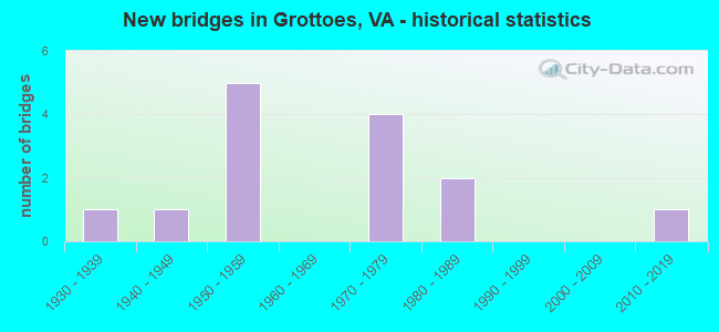
- New bridges - historical statistics
- 11930-1939
- 11940-1949
- 51950-1959
- 41970-1979
- 21980-1989
- 12010-2019

- Reconstructed bridges - Historical Statistics
- 11970-1979
- 11980-1989
- 01990-1999
- 12000-2009
- 22010-2019


- Bridge Condition - Deck
- 30.0%Very good
- 10.0%Good
- 20.0%Satisfactory
- 40.0%Fair

- Bridge Condition - Superstructure
- 18.2%Very good
- 45.5%Good
- 27.3%Satisfactory
- 9.1%Fair

- Bridge Condition - Substructure
- 36.4%Good
- 27.3%Satisfactory
- 36.4%Fair

- Bridge Condition - Channel
- 21.4%Very good
- 35.7%Good
- 28.6%Satisfactory
- 7.1%Fair
- 7.1%Poor

- Bridge Condition - Culverts
- 66.7%Very good
- 33.3%Good
Find on map >> Show street view
Structure Number: 1907, Location: 00 AUGUSTA- 00 ROCKINGHAM (Lat: 38.265481, Lng: -78.836839), Route carried "on" structure: State highway 256, Year Built: 1952, Status: Open, Structure Length: 9.60m (31.50ft), Average Daily Traffic: 5,736 (year 2020), Truck Traffic: 6%, Average Future Daily Traffic: 6,807 (year 2040), Design Load: HS 20+Mod, Features Intersected: SOUTH RIVER, Facility Carried by Structure: WEYERS CAVE RD.
Minimum Vertical Clearance: 30+ m (98+ ft), Kilometerpoint: 9.318, Lanes on structure: 2, Base Highway Network: Yes, Owner: State Highway Agency, Approaching Roadway Width: 10.4m (34.1ft), Skew: 2 degrees, Material/Design: Steel, Design/Construction: Stringer/Multi-beam, Number Of Spans In Main Unit: 5, Length of Maximum Span: 19.1m (62.7ft), Curb or Sidewalk Widths: Left: 0.5m (1.6ft), Right: 0.5m (1.6ft), Curb-To-Curb Width: 7.9m (25.9ft), Out-to-Out Width: 8.4m (27.6ft)
Condition: Deck: Fair, Superstructure: Good, Substructure: Satisfactory, Channel: Good, Operating Rating: 40.8 metric tons, Method Used To Determine Operating Rating: Load and Resistance Factor (LRFR), Inventory Rating: 30.8 metric tons, Method Used To Determine Inventory Rating: Load and Resistance Factor (LRFR), Structural Evaluation: Equal to present minimum criteria, Deck Geometry: High priority of corrective action, Waterway Adequacy: Equal to present minimum criteria, Approach Roadway Alignment: Somewhat better than minimum adequacy, Length Of Structure Improvement: 9.60m (31.50ft), Designated Inspection Frequency: Every 24 months, Inspection Date: August 2020, Bridge Improvement Cost: $150,000, Roadway Improvement Cost: $10,000, Total Project Cost: $160,000, Deck Structure Type: Concrete Cast-file-Place, Wearing Surface/Protective System: Wearing Surface: Latex Concrete
Find on map >> Show street view
Structure Number: 2382, Location: 0.01 DEAD END-0.19 RT 825 (Lat: 38.259006, Lng: -78.834025), Route carried "on" structure: County highway 844, Year Built: 1932, Status: Open, Structure Length: 0.92m (3.02ft), Average Daily Traffic: 211 (year 2013), Average Future Daily Traffic: 325 (year 2040), Design Load: HS 20+Mod, Features Intersected: OVERFLOW SOUTH RIVER, Facility Carried by Structure: GRAND CAVERNS RD
Minimum Vertical Clearance: 30+ m (98+ ft), Kilometerpoint: 0.016, Lanes on structure: 2, Owner: State Highway Agency, Approaching Roadway Width: 4.9m (16.1ft), Material/Design: Steel, Design/Construction: Stringer/Multi-beam, Number Of Spans In Main Unit: 1, Length of Maximum Span: 8.5m (27.9ft), Curb or Sidewalk Widths: Left: 0.2m (0.7ft), Right: 0.2m (0.7ft), Curb-To-Curb Width: 7.0m (23.0ft), Out-to-Out Width: 7.3m (24.0ft)
Condition: Deck: Very good, Superstructure: Good, Substructure: Good, Channel: Very good, Operating Rating: 49.9 metric tons, Method Used To Determine Operating Rating: Load and Resistance Factor (LRFR), Inventory Rating: 38.1 metric tons, Method Used To Determine Inventory Rating: Load and Resistance Factor (LRFR), Structural Evaluation: Better than present minimum criteria, Deck Geometry: Meets minimum limits, Waterway Adequacy: Better than present minimum criteria, Approach Roadway Alignment: Equal to present desirable criteria, Designated Inspection Frequency: Every 24 months, Inspection Date: October 2021, Deck Structure Type: Wood or Timber, Wearing Surface/Protective System: Wearing Surface: Bituminous
Find on map >> Show street view
Structure Number: 15741, Location: 0.15 RT 659 - 0.30 RT 708 (Lat: 38.258842, Lng: -78.778619), Route carried "on" structure: County highway 663, Year Built: 1952, Year Reconstructed: 1978, Status: Open, Structure Length: 1.43m (4.69ft), Average Daily Traffic: 307 (year 2015), Average Future Daily Traffic: 438 (year 2040), Design Load: HS 20, Features Intersected: MADISON RUN, Facility Carried by Structure: BROWNS GAP RD
Minimum Vertical Clearance: 30+ m (98+ ft), Kilometerpoint: 3.298, Lanes on structure: 2, Owner: State Highway Agency, Approaching Roadway Width: 7.3m (24.0ft), Skew: 2 degrees, Material/Design: Concrete continuous, Design/Construction: Slab, Number Of Spans In Main Unit: 2, Length of Maximum Span: 7.0m (23.0ft), Curb-To-Curb Width: 7.3m (24.0ft), Out-to-Out Width: 8.3m (27.2ft)
Condition: Deck: Satisfactory, Superstructure: Satisfactory, Substructure: Fair, Channel: Poor, Operating Rating: 39.9 metric tons, Method Used To Determine Operating Rating: Load and Resistance Factor (LRFR), Inventory Rating: 30.8 metric tons, Method Used To Determine Inventory Rating: Load and Resistance Factor (LRFR), Structural Evaluation: Somewhat better than minimum adequacy, Deck Geometry: Somewhat better than minimum adequacy, Waterway Adequacy: Equal to present desirable criteria, Approach Roadway Alignment: Equal to present desirable criteria, Length Of Structure Improvement: 1.46m (4.79ft), Designated Inspection Frequency: Every 12 months, Inspection Date: June 2021, Bridge Improvement Cost: $3,000, Roadway Improvement Cost: $1,000, Total Project Cost: $5,000, Deck Structure Type: Concrete Cast-file-Place
Find on map >> Show street view
Structure Number: 15892, Location: 0.29 RT 659 - 1.22 RT 955 (Lat: 38.285700, Lng: -78.794697), Route carried "on" structure: US 340, Year Built: 1942, Status: Open, Structure Length: 5.18m (16.99ft), Average Daily Traffic: 3,178 (year 2020), Truck Traffic: 10%, Average Future Daily Traffic: 3,496 (year 2040), Design Load: H 15, Features Intersected: MADISON RUN
Minimum Vertical Clearance: 30+ m (98+ ft), Kilometerpoint: 52.498, Lanes on structure: 2, Base Highway Network: Yes, Owner: State Highway Agency, Approaching Roadway Width: 7.3m (24.0ft), Material/Design: Concrete, Design/Construction: Tee Beam, Number Of Spans In Main Unit: 4, Length of Maximum Span: 13.0m (42.7ft), Curb or Sidewalk Widths: Left: 0.5m (1.6ft), Right: 0.5m (1.6ft), Curb-To-Curb Width: 7.9m (25.9ft), Out-to-Out Width: 8.4m (27.6ft)
Condition: Deck: Fair, Superstructure: Satisfactory, Substructure: Fair, Channel: Satisfactory, Operating Rating: 35.1 metric tons, Method Used To Determine Operating Rating: Load and Resistance Factor (LRFR), Inventory Rating: 27.0 metric tons, Method Used To Determine Inventory Rating: Load and Resistance Factor (LRFR), Structural Evaluation: Somewhat better than minimum adequacy, Deck Geometry: High priority of corrective action, Waterway Adequacy: Equal to present minimum criteria, Approach Roadway Alignment: Equal to present minimum criteria, Length Of Structure Improvement: 5.18m (16.99ft), Designated Inspection Frequency: Every 24 months, Other Special Inspection Frequency: Every 12 months, Inspection Date: July 2021, Other Special Inspection Date: July 2021, Bridge Improvement Cost: $95,000, Roadway Improvement Cost: $10,000, Total Project Cost: $143,000, Deck Structure Type: Concrete Cast-file-Place, Wearing Surface/Protective System: Wearing Surface: Latex Concrete
Find on map >> Show street view
Structure Number: 16009, Location: 0.10 TO 605 - .30 TO 1601 (Lat: 38.297550, Lng: -78.811336), Route carried "on" structure: State highway 253, Year Built: 1956, Status: Open, Structure Length: 15.06m (49.41ft), Average Daily Traffic: 5,775 (year 2020), Truck Traffic: 3%, Average Future Daily Traffic: 5,860 (year 2040), Design Load: HS 15, Features Intersected: NORTH RV @ PORT-REPUBLIC, Facility Carried by Structure: PORT REPUBLIC RD
Minimum Vertical Clearance: 30+ m (98+ ft), Kilometerpoint: 14.626, Lanes on structure: 2, Base Highway Network: Yes, Owner: State Highway Agency, Approaching Roadway Width: 7.3m (24.0ft), Material/Design: Steel continuous, Design/Construction: Stringer/Multi-beam, Number Of Spans In Main Unit: 3, Number Of Approach Spans: 4, Length of Maximum Span: 28.3m (92.8ft), Curb or Sidewalk Widths: Left: 0.5m (1.6ft), Right: 0.5m (1.6ft), Curb-To-Curb Width: 7.3m (24.0ft), Out-to-Out Width: 8.2m (26.9ft)
Condition: Deck: Fair, Superstructure: Satisfactory, Substructure: Fair, Channel: Fair, Operating Rating: 44.5 metric tons, Method Used To Determine Operating Rating: Load and Resistance Factor (LRFR), Inventory Rating: 34.5 metric tons, Method Used To Determine Inventory Rating: Load and Resistance Factor (LRFR), Structural Evaluation: Somewhat better than minimum adequacy, Deck Geometry: High priority of replacement, Waterway Adequacy: Better than present minimum criteria, Approach Roadway Alignment: Equal to present minimum criteria, Length Of Structure Improvement: 15.06m (49.41ft), Designated Inspection Frequency: Every 24 months, Inspection Date: July 2021, Bridge Improvement Cost: $65,000, Roadway Improvement Cost: $2,000, Total Project Cost: $90,000, Deck Structure Type: Concrete Cast-file-Place, Wearing Surface/Protective System: Wearing Surface: Bituminous, Membrane: Epoxy
Find on map >> Show street view
Structure Number: 1601, Location: 0.50 RT 671 - 0.10 RT 672 (Lat: 38.324067, Lng: -78.815689), Route carried "on" structure: State highway 253, Year Built: 1957, Year Reconstructed: 1993, Status: Open, Structure Length: 3.90m (12.80ft), Average Daily Traffic: 5,752 (year 2020), Truck Traffic: 3%, Average Future Daily Traffic: 6,327 (year 2040), Design Load: HS 15, Features Intersected: MILL CREEK, Facility Carried by Structure: PORT REPUBLIC RD
Minimum Vertical Clearance: 30+ m (98+ ft), Kilometerpoint: 11.424, Lanes on structure: 2, Owner: State Highway Agency, Approaching Roadway Width: 6.1m (20.0ft), Material/Design: Concrete, Design/Construction: Tee Beam, Number Of Spans In Main Unit: 3, Length of Maximum Span: 13.0m (42.7ft), Curb or Sidewalk Widths: Left: 0.5m (1.6ft), Right: 0.5m (1.6ft), Curb-To-Curb Width: 7.3m (24.0ft), Out-to-Out Width: 7.9m (25.9ft)
Condition: Deck: Fair, Superstructure: Fair, Substructure: Fair, Channel: Very good, Operating Rating: 55.3 metric tons, Method Used To Determine Operating Rating: Load Factor (LF), Inventory Rating: 32.7 metric tons, Method Used To Determine Inventory Rating: Load Factor (LF), Structural Evaluation: Somewhat better than minimum adequacy, Deck Geometry: High priority of replacement, Waterway Adequacy: Equal to present minimum criteria, Approach Roadway Alignment: Equal to present desirable criteria, Length Of Structure Improvement: 3.96m (12.99ft), Designated Inspection Frequency: Every 12 months, Inspection Date: November 2021, Bridge Improvement Cost: $350,000, Roadway Improvement Cost: $20,000, Total Project Cost: $400,000, Deck Structure Type: Concrete Cast-file-Place, Wearing Surface/Protective System: Wearing Surface: Bituminous
Find on map >> Show street view
Structure Number: 16012, Location: 1.11 RT 669 - 0.40 RT 667 (Lat: 38.282092, Lng: -78.851881), Route carried "on" structure: County highway 668, Year Built: 1986, Status: Open, Structure Length: 8.91m (29.23ft), Average Daily Traffic: 289 (year 2018), Average Future Daily Traffic: 416 (year 2040), Design Load: HS 20+Mod, Features Intersected: NORTH RIVER, Facility Carried by Structure: E TIMBER RIDGE RD
Minimum Vertical Clearance: 30+ m (98+ ft), Kilometerpoint: 7.055, Lanes on structure: 2, Owner: State Highway Agency, Approaching Roadway Width: 7.9m (25.9ft), Material/Design: Steel, Design/Construction: Stringer/Multi-beam, Number Of Spans In Main Unit: 4, Length of Maximum Span: 21.7m (71.2ft), Curb-To-Curb Width: 7.5m (24.6ft), Out-to-Out Width: 8.5m (27.9ft)
Condition: Deck: Good, Superstructure: Good, Substructure: Good, Channel: Good, Operating Rating: 89.8 metric tons, Method Used To Determine Operating Rating: Load and Resistance Factor (LRFR), Inventory Rating: 77.1 metric tons, Method Used To Determine Inventory Rating: Load and Resistance Factor (LRFR), Structural Evaluation: Better than present minimum criteria, Deck Geometry: Somewhat better than minimum adequacy, Waterway Adequacy: Better than present minimum criteria, Approach Roadway Alignment: Equal to present minimum criteria, Designated Inspection Frequency: Every 24 months, Inspection Date: April 2021, Deck Structure Type: Concrete Cast-file-Place, Wearing Surface/Protective System: Deck Protection: Epoxy Coated Reinforcing
Find on map >> Show street view
Structure Number: 16015, Location: 0.02 RT 670 - 0.30 RT 828 (Lat: 38.316317, Lng: -78.818636), Route carried "on" structure: County highway 671, Year Built: 1976, Year Reconstructed: 2010, Status: Open, Structure Length: 1.49m (4.89ft), Average Daily Traffic: 191 (year 2018), Average Future Daily Traffic: 212 (year 2040), Features Intersected: MILL CREEK, Facility Carried by Structure: SHADY GROVE RD
Minimum Vertical Clearance: 30+ m (98+ ft), Kilometerpoint: 5.438, Lanes on structure: 1, Owner: State Highway Agency, Approaching Roadway Width: 4.6m (15.1ft), Material/Design: Prestressed concrete, Design/Construction: Box Beam or Girders - Multiple, Number Of Spans In Main Unit: 1, Length of Maximum Span: 14.2m (46.6ft), Curb-To-Curb Width: 4.7m (15.4ft), Out-to-Out Width: 4.9m (16.1ft)
Condition: Deck: Very good, Superstructure: Very good, Substructure: Good, Channel: Good, Operating Rating: 68.9 metric tons, Method Used To Determine Operating Rating: Load and Resistance Factor (LRFR), Inventory Rating: 53.5 metric tons, Method Used To Determine Inventory Rating: Load and Resistance Factor (LRFR), Structural Evaluation: Better than present minimum criteria, Deck Geometry: High priority of replacement, Waterway Adequacy: Somewhat better than minimum adequacy, Approach Roadway Alignment: Equal to present minimum criteria, Length Of Structure Improvement: 1.49m (4.89ft), Designated Inspection Frequency: Every 24 months, Inspection Date: Febuary 2021, Bridge Improvement Cost: $50,000, Roadway Improvement Cost: $5,000, Total Project Cost: $65,000, Deck Structure Type: Other, Wearing Surface/Protective System: Wearing Surface: Bituminous, Membrane: Epoxy, Deck Protection: Other
Find on map >> Show street view
Structure Number: 16049, Location: 1.00 TO 655 - 0.10 TO 788 (Lat: 38.311536, Lng: -78.771119), Route carried "on" structure: County highway 708, Year Built: 1977, Status: Open, Structure Length: 14.70m (48.23ft), Average Daily Traffic: 445 (year 2012), Average Future Daily Traffic: 674 (year 2040), Design Load: HS 20+Mod, Features Intersected: S F SHENANDOAH RIVER, Facility Carried by Structure: LYNNWOOD RD
Minimum Vertical Clearance: 30+ m (98+ ft), Kilometerpoint: 9.059, Lanes on structure: 2, Owner: State Highway Agency, Approaching Roadway Width: 7.9m (25.9ft), Skew: 3 degrees, Material/Design: Steel, Design/Construction: Stringer/Multi-beam, Number Of Spans In Main Unit: 6, Length of Maximum Span: 24.7m (81.0ft), Curb-To-Curb Width: 8.1m (26.6ft), Out-to-Out Width: 9.1m (29.9ft)
Condition: Deck: Satisfactory, Superstructure: Good, Substructure: Satisfactory, Channel: Satisfactory, Operating Rating: 66.2 metric tons, Method Used To Determine Operating Rating: Load and Resistance Factor (LRFR), Inventory Rating: 50.8 metric tons, Method Used To Determine Inventory Rating: Load and Resistance Factor (LRFR), Structural Evaluation: Equal to present minimum criteria, Deck Geometry: Somewhat better than minimum adequacy, Waterway Adequacy: Equal to present minimum criteria, Approach Roadway Alignment: Equal to present desirable criteria, Designated Inspection Frequency: Every 24 months, Underwater Inspection Frequency: Every 60 months, Inspection Date: April 2021, Underwater Inspection Date: July 2019, Deck Structure Type: Concrete Cast-file-Place, Wearing Surface/Protective System: Wearing Surface: Epoxy Overlay
Find on map >> Show street view
Structure Number: 16203, Location: 0.00 14TH ST/0.00 14TH_ST (Lat: 38.272236, Lng: -78.823350), Route carried "on" structure: City street , Year Built: 1974, Status: Open, Structure Length: 0.73m (2.40ft), Average Daily Traffic: 2,568 (year 2020), Average Future Daily Traffic: 2,825 (year 2040), Design Load: HS 20, Features Intersected: MILLER RUN, Facility Carried by Structure: DOGWOOD AVENUE
Minimum Vertical Clearance: 30+ m (98+ ft), Kilometerpoint: 1.940, Lanes on structure: 2, Owner: Town or Township Highway Agency, Approaching Roadway Width: 10.4m (34.1ft), Skew: 5 degrees, Material/Design: Steel, Design/Construction: Culvert, Number Of Spans In Main Unit: 4, Length of Maximum Span: 1.8m (5.9ft)
Condition: Channel: Satisfactory, Culverts: Good, Operating Rating: 54.4 metric tons, Method Used To Determine Operating Rating: Load Factor (LF), Inventory Rating: 32.7 metric tons, Method Used To Determine Inventory Rating: Load Factor (LF), Structural Evaluation: Better than present minimum criteria, Waterway Adequacy: Better than present minimum criteria, Approach Roadway Alignment: Equal to present minimum criteria, Designated Inspection Frequency: Every 24 months, Inspection Date: Febuary 2022
Find on map >> Show street view
Structure Number: 16208, Location: 0.85 RT 671 - 0.75 RT 668 (Lat: 38.310072, Lng: -78.833422), Route carried "on" structure: County highway 828, Year Built: 1980, Status: Open, Structure Length: 1.01m (3.31ft), Average Daily Traffic: 225 (year 2015), Average Future Daily Traffic: 338 (year 2040), Design Load: HS 20+Mod, Features Intersected: TRIB NORTH RIVER, Facility Carried by Structure: STONEY LICK RD
Minimum Vertical Clearance: 30+ m (98+ ft), Kilometerpoint: 1.207, Lanes on structure: 2, Owner: State Highway Agency, Approaching Roadway Width: 6.4m (21.0ft), Material/Design: Steel, Design/Construction: Arch - Deck, Number Of Spans In Main Unit: 1, Length of Maximum Span: 10.1m (33.1ft), Curb-To-Curb Width: 6.4m (21.0ft), Out-to-Out Width: 24.4m (80.1ft)
Condition: Superstructure: Good, Substructure: Good, Channel: Very good, Operating Rating: 68.0 metric tons, Method Used To Determine Operating Rating: Load and Resistance Factor (LRFR), Inventory Rating: 52.6 metric tons, Method Used To Determine Inventory Rating: Load and Resistance Factor (LRFR), Structural Evaluation: Better than present minimum criteria, Deck Geometry: Meets minimum limits, Waterway Adequacy: Equal to present minimum criteria, Approach Roadway Alignment: Equal to present minimum criteria, Designated Inspection Frequency: Every 24 months, Inspection Date: April 2021
Find on map >> Show street view
Structure Number: 16243, Location: 0.20 RT 1604- 1.40 RT 340 (Lat: 38.295581, Lng: -78.803611), Route carried "on" structure: County highway 955, Year Built: 1950, Year Reconstructed: 2010, Status: Open, Structure Length: 0.80m (2.62ft), Average Daily Traffic: 161 (year 2018), Average Future Daily Traffic: 215 (year 2040), Design Load: HS 20+Mod, Features Intersected: MADISON RUN, Facility Carried by Structure: JACKSONS WAY
Minimum Vertical Clearance: 30+ m (98+ ft), Kilometerpoint: 0.716, Lanes on structure: 1, Owner: State Highway Agency, Approaching Roadway Width: 3.7m (12.1ft), Material/Design: Concrete, Design/Construction: Slab, Number Of Spans In Main Unit: 1, Length of Maximum Span: 8.0m (26.2ft), Curb-To-Curb Width: 4.7m (15.4ft), Out-to-Out Width: 4.9m (16.1ft)
Condition: Deck: Very good, Superstructure: Very good, Substructure: Satisfactory, Channel: Satisfactory, Operating Rating: 59.9 metric tons, Method Used To Determine Operating Rating: Load and Resistance Factor (LRFR), Inventory Rating: 46.3 metric tons, Method Used To Determine Inventory Rating: Load and Resistance Factor (LRFR), Structural Evaluation: Equal to present minimum criteria, Deck Geometry: High priority of replacement, Waterway Adequacy: Better than present minimum criteria, Approach Roadway Alignment: Better than present minimum criteria, Length Of Structure Improvement: 0.82m (2.69ft), Designated Inspection Frequency: Every 24 months, Inspection Date: January 2021, Bridge Improvement Cost: $141,000, Roadway Improvement Cost: $15,000, Total Project Cost: $212,000, Deck Structure Type: Other, Wearing Surface/Protective System: Wearing Surface: Bituminous, Membrane: Epoxy, Deck Protection: Galvanized Reinforcing
Find on map >> Show street view
Structure Number: 16262, Location: .01 DOGWD AVE/0.1 ELM AVE (Lat: 38.277306, Lng: -78.820722), Route carried "on" structure: City street , Year Built: 1974, Year Reconstructed: 2014, Status: Open, Structure Length: 0.73m (2.40ft), Average Daily Traffic: 406 (year 1981), Average Future Daily Traffic: 800 (year 2033), Design Load: HS 20, Features Intersected: MILLER RUN, Facility Carried by Structure: 20TH STREET
Minimum Vertical Clearance: 30+ m (98+ ft), Kilometerpoint: 0.000, Lanes on structure: 2, Owner: Town or Township Highway Agency, Approaching Roadway Width: 6.7m (22.0ft), Material/Design: Steel, Design/Construction: Culvert, Number Of Spans In Main Unit: 4, Length of Maximum Span: 1.8m (5.9ft)
Condition: Channel: Good, Culverts: Very good, Operating Rating: 54.4 metric tons, Method Used To Determine Operating Rating: Load Factor (LF), Inventory Rating: 32.7 metric tons, Method Used To Determine Inventory Rating: Load Factor (LF), Structural Evaluation: Equal to present desirable criteria, Waterway Adequacy: Equal to present minimum criteria, Approach Roadway Alignment: Equal to present minimum criteria, Designated Inspection Frequency: Every 24 months, Inspection Date: Febuary 2022
Find on map >> Show street view
Structure Number: 30994, Location: 0.33 RT 672 - 0.37 RT 828 (Lat: 38.313550, Lng: -78.847169), Route carried "on" structure: County highway 668, Year Built: 2017, Status: Open, Structure Length: 0.69m (2.26ft), Average Daily Traffic: 226 (year 2018), Average Future Daily Traffic: 325 (year 2040), Design Load: HS 20+Mod, Features Intersected: STREAM, Facility Carried by Structure: E TIMBER RIDGE RD
Minimum Vertical Clearance: 30+ m (98+ ft), Kilometerpoint: 3.374, Lanes on structure: 2, Owner: State Highway Agency, Approaching Roadway Width: 5.5m (18.0ft), Skew: 2 degrees, Material/Design: Concrete, Design/Construction: Culvert, Number Of Spans In Main Unit: 2, Length of Maximum Span: 3.0m (9.8ft), Curb-To-Curb Width: 8.2m (26.9ft), Out-to-Out Width: 11.0m (36.1ft)
Condition: Channel: Good, Culverts: Very good, Operating Rating: 54.4 metric tons, Method Used To Determine Operating Rating: Field evaluation and documented engineering judgment, Inventory Rating: 32.7 metric tons, Method Used To Determine Inventory Rating: Field evaluation and documented engineering judgment, Structural Evaluation: Equal to present desirable criteria, Deck Geometry: Somewhat better than minimum adequacy, Waterway Adequacy: Meets minimum limits, Approach Roadway Alignment: Meets minimum limits, Length Of Structure Improvement: 0.61m (2.00ft), Designated Inspection Frequency: Every 24 months, Inspection Date: July 2021, Bridge Improvement Cost: $37,000, Roadway Improvement Cost: $4,000, Total Project Cost: $56,000