Bridge Statistics for Groveland, New York (NY)
Condition, Traffic, Stress, Structural Evaluation, Project Costs
- National Bridge Inventory (NBI) Statistics
- 25Number of bridges
- 236ft / 72.1mTotal length
- $42,861,000Total costs
- 90,010Total average daily traffic
- 18,908Total average daily truck traffic
- National Bridge Inventory (NBI) Registered Bridges for Groveland
- No street view available for this location
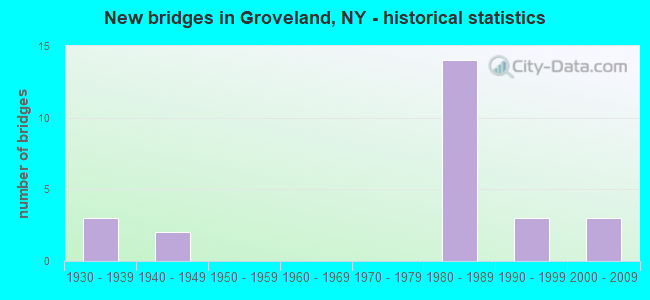
- New bridges - historical statistics
- 31930-1939
- 21940-1949
- 141980-1989
- 31990-1999
- 32000-2009


- Bridge Condition - Deck
- 25.0%Very good
- 31.3%Good
- 18.8%Satisfactory
- 25.0%Fair

- Bridge Condition - Superstructure
- 31.3%Very good
- 56.3%Good
- 6.3%Fair
- 6.3%Poor

- Bridge Condition - Substructure
- 12.5%Very good
- 43.8%Good
- 37.5%Satisfactory
- 6.3%Fair

- Bridge Condition - Channel
- 13.3%Very good
- 40.0%Good
- 33.3%Satisfactory
- 6.7%Fair
- 6.7%Poor

- Bridge Condition - Culverts
- 50.0%Good
- 25.0%Satisfactory
- 25.0%Fair
Find on map >> Show street view
Structure Number: 102365, Location: 1.2 M NW JCT RT 36 & I390 (Lat: 42.683328, Lng: -77.828506), Route carried "on" structure: State highway 36, Year Built: 1996, Status: Open, Structure Length: 4.05m (13.29ft), Average Daily Traffic: 5,833 (year 2018), Truck Traffic: 14%, Average Future Daily Traffic: 5,869 (year 2040), Design Load: HS 25 or greater, Features Intersected: KESHEQUA CREEK
Minimum Vertical Clearance: 30+ m (98+ ft), Kilometerpoint: 21.384, Lanes on structure: 2, Base Highway Network: Yes, Owner: State Highway Agency, Approaching Roadway Width: 12.2m (40.0ft), Skew: 3 degrees, Material/Design: Steel, Design/Construction: Stringer/Multi-beam, Number Of Spans In Main Unit: 1, Length of Maximum Span: 38.7m (127.0ft), Curb-To-Curb Width: 12.2m (40.0ft), Out-to-Out Width: 12.8m (42.0ft)
Condition: Deck: Good, Superstructure: Good, Substructure: Good, Channel: Good, Operating Rating: 96.2 metric tons, Method Used To Determine Operating Rating: Load Factor (LF), Inventory Rating: 57.2 metric tons, Method Used To Determine Inventory Rating: Load Factor (LF), Structural Evaluation: Better than present minimum criteria, Deck Geometry: Somewhat better than minimum adequacy, Waterway Adequacy: Superior to present desirable criteria, Approach Roadway Alignment: Equal to present desirable criteria, Length Of Structure Improvement: 4.05m (13.29ft), Designated Inspection Frequency: Every 24 months, Inspection Date: May 2020, Bridge Improvement Cost: $1,679,000, Roadway Improvement Cost: $984,000, Total Project Cost: $2,663,000 ( Estimate for 2021), Deck Structure Type: Concrete Cast-file-Place, Wearing Surface/Protective System: Wearing Surface: Integral Concrete, Deck Protection: Epoxy Coated Reinforcing
Find on map >> Show street view
Structure Number: 102867, Location: 0.8MI NE JCT RTS 63 + 258 (Lat: 42.670781, Lng: -77.776569), Route carried "on" structure: State highway 63, Year Built: 1939, Status: Open, Structure Length: 0.76m (2.49ft), Average Daily Traffic: 1,483 (year 2016), Truck Traffic: 9%, Average Future Daily Traffic: 1,492 (year 2040), Features Intersected: Mosquito Creek
Minimum Vertical Clearance: 30+ m (98+ ft), Kilometerpoint: 17.973, Lanes on structure: 2, Base Highway Network: Yes, Owner: State Highway Agency, Approaching Roadway Width: 10.4m (34.1ft), Skew: 3 degrees, Material/Design: Concrete, Design/Construction: Culvert, Number Of Spans In Main Unit: 1, Length of Maximum Span: 6.4m (21.0ft)
Condition: Channel: Satisfactory, Culverts: Good, Structural Evaluation: Better than present minimum criteria, Waterway Adequacy: Somewhat better than minimum adequacy, Approach Roadway Alignment: Equal to present desirable criteria, Length Of Structure Improvement: 0.76m (2.49ft), Designated Inspection Frequency: Every 24 months, Inspection Date: September 2020, Bridge Improvement Cost: $246,000, Roadway Improvement Cost: $144,000, Total Project Cost: $391,000 ( Estimate for 2021), Wearing Surface/Protective System: Wearing Surface: Bituminous
Find on map >> Show street view
Structure Number: 102868, Location: 3.2MI NE JCT RTS 63 + 258 (Lat: 42.721653, Lng: -77.817678), Route carried "on" structure: State highway 63, Year Built: 1994, Status: Open, Structure Length: 2.38m (7.81ft), Average Daily Traffic: 1,483 (year 2016), Truck Traffic: 9%, Average Future Daily Traffic: 1,492 (year 2040), Design Load: HS 25 or greater, Features Intersected: MILL GULLY CREEK
Minimum Vertical Clearance: 30+ m (98+ ft), Kilometerpoint: 24.795, Lanes on structure: 2, Base Highway Network: Yes, Owner: State Highway Agency, Approaching Roadway Width: 10.7m (35.1ft), Material/Design: Prestressed concrete, Design/Construction: Box Beam or Girders - Multiple, Number Of Spans In Main Unit: 1, Length of Maximum Span: 22.8m (74.8ft), Curb-To-Curb Width: 10.8m (35.4ft), Out-to-Out Width: 11.4m (37.4ft)
Condition: Deck: Very good, Superstructure: Good, Substructure: Good, Channel: Good, Operating Rating: 99.8 metric tons, Method Used To Determine Operating Rating: Load Factor (LF), Inventory Rating: 56.2 metric tons, Method Used To Determine Inventory Rating: Load Factor (LF), Structural Evaluation: Better than present minimum criteria, Deck Geometry: Equal to present minimum criteria, Waterway Adequacy: Equal to present minimum criteria, Approach Roadway Alignment: Equal to present desirable criteria, Length Of Structure Improvement: 2.37m (7.78ft), Designated Inspection Frequency: Every 24 months, Inspection Date: June 2020, Bridge Improvement Cost: $525,000, Roadway Improvement Cost: $308,000, Total Project Cost: $833,000 ( Estimate for 2021), Deck Structure Type: Concrete Cast-file-Place, Wearing Surface/Protective System: Wearing Surface: Bituminous, Membrane: Preformed Fabric, Deck Protection: Epoxy Coated Reinforcing
Find on map >> Show street view
Structure Number: 102869, Location: 5.2MI NE JCT RTS 63 + 258 (Lat: 42.702453, Lng: -77.794383), Route carried "on" structure: State highway 63, Year Built: 1939, Status: Open, Structure Length: 0.73m (2.40ft), Average Daily Traffic: 1,483 (year 2016), Truck Traffic: 9%, Average Future Daily Traffic: 1,492 (year 2040), Design Load: HS 15, Features Intersected: UNKNOWN CR
Minimum Vertical Clearance: 30+ m (98+ ft), Kilometerpoint: 21.786, Lanes on structure: 2, Base Highway Network: Yes, Owner: State Highway Agency, Approaching Roadway Width: 10.7m (35.1ft), Skew: 3 degrees, Material/Design: Concrete, Design/Construction: Culvert, Number Of Spans In Main Unit: 1, Length of Maximum Span: 6.4m (21.0ft)
Condition: Channel: Poor, Culverts: Good, Inventory Rating: 82.6 metric tons, Method Used To Determine Inventory Rating: Load Factor (LF), Structural Evaluation: Better than present minimum criteria, Waterway Adequacy: Meets minimum limits, Approach Roadway Alignment: Equal to present desirable criteria, Length Of Structure Improvement: 0.73m (2.40ft), Designated Inspection Frequency: Every 24 months, Inspection Date: September 2020, Bridge Improvement Cost: $254,000, Roadway Improvement Cost: $149,000, Total Project Cost: $402,000 ( Estimate for 2021), Wearing Surface/Protective System: Wearing Surface: Bituminous
Find on map >> Show street view
Structure Number: 104352, Location: 0.6MI E JCT RTS 258 + 36 (Lat: 42.661081, Lng: -77.792233), Route carried "on" structure: State highway 258, Year Built: 1940, Status: Open, Structure Length: 1.34m (4.40ft), Average Daily Traffic: 449 (year 2019), Truck Traffic: 15%, Average Future Daily Traffic: 629 (year 2039), Design Load: H 20, Features Intersected: WEST DITCH
Minimum Vertical Clearance: 30+ m (98+ ft), Kilometerpoint: 0.917, Lanes on structure: 2, Base Highway Network: Yes, Owner: State Highway Agency, Approaching Roadway Width: 10.4m (34.1ft), Material/Design: Steel, Design/Construction: Stringer/Multi-beam, Number Of Spans In Main Unit: 1, Length of Maximum Span: 12.1m (39.7ft), Curb-To-Curb Width: 8.2m (26.9ft), Out-to-Out Width: 9.1m (29.9ft)
Condition: Deck: Very good, Superstructure: Good, Substructure: Good, Channel: Satisfactory, Operating Rating: 39.9 metric tons, Method Used To Determine Operating Rating: Load Factor (LF), Inventory Rating: 23.6 metric tons, Method Used To Determine Inventory Rating: Load Factor (LF), Structural Evaluation: Equal to present minimum criteria, Deck Geometry: Somewhat better than minimum adequacy, Waterway Adequacy: Better than present minimum criteria, Approach Roadway Alignment: Equal to present desirable criteria, Length Of Structure Improvement: 1.34m (4.40ft), Designated Inspection Frequency: Every 24 months, Inspection Date: September 2021, Bridge Improvement Cost: $533,000, Roadway Improvement Cost: $312,000, Total Project Cost: $846,000 ( Estimate for 2021), Deck Structure Type: Concrete Cast-file-Place, Wearing Surface/Protective System: Wearing Surface: Epoxy Overlay
Find on map >> Show street view
Structure Number: 104353, Location: 0.8MI E JCT RTS 258 + 36 (Lat: 42.660992, Lng: -77.787456), Route carried "on" structure: State highway 258, Year Built: 1938, Status: Posted for load-capacity, Structure Length: 0.79m (2.59ft), Average Daily Traffic: 449 (year 2019), Truck Traffic: 15%, Average Future Daily Traffic: 629 (year 2039), Design Load: H 20, Features Intersected: BIG DITCH OVERFLW
Minimum Vertical Clearance: 30+ m (98+ ft), Kilometerpoint: 1.303, Lanes on structure: 2, Base Highway Network: Yes, Owner: State Highway Agency, Approaching Roadway Width: 10.4m (34.1ft), Skew: 2 degrees, Material/Design: Concrete, Design/Construction: Frame, Number Of Spans In Main Unit: 2, Length of Maximum Span: 3.4m (11.2ft), Curb-To-Curb Width: 8.8m (28.9ft), Out-to-Out Width: 9.8m (32.2ft)
Condition: Deck: Fair, Superstructure: Fair, Substructure: Satisfactory, Channel: Satisfactory, Operating Rating: 41.7 metric tons, Method Used To Determine Operating Rating: Load Factor (LF), Structural Evaluation: High priority of corrective action, Deck Geometry: Somewhat better than minimum adequacy, Waterway Adequacy: Equal to present minimum criteria, Approach Roadway Alignment: Better than present minimum criteria, Length Of Structure Improvement: 0.79m (2.59ft), Designated Inspection Frequency: Every 24 months, Inspection Date: July 2021, Bridge Improvement Cost: $229,000, Roadway Improvement Cost: $134,000, Total Project Cost: $364,000 ( Estimate for 2021)
Find on map >> Show street view
Structure Number: 104354, Location: 1.2MI E JCT RTS 258 + 36 (Lat: 42.660867, Lng: -77.780583), Route carried "on" structure: State highway 258, Year Built: 1940, Year Reconstructed: 1988, Status: Open, Structure Length: 0.98m (3.22ft), Average Daily Traffic: 449 (year 2019), Truck Traffic: 15%, Average Future Daily Traffic: 629 (year 2039), Design Load: H 20, Features Intersected: BRADNER CREEK
Minimum Vertical Clearance: 30+ m (98+ ft), Kilometerpoint: 1.866, Lanes on structure: 2, Base Highway Network: Yes, Owner: State Highway Agency, Approaching Roadway Width: 9.1m (29.9ft), Skew: 2 degrees, Material/Design: Steel, Design/Construction: Stringer/Multi-beam, Number Of Spans In Main Unit: 1, Length of Maximum Span: 9.4m (30.8ft), Curb-To-Curb Width: 8.5m (27.9ft), Out-to-Out Width: 9.1m (29.9ft)
Condition: Deck: Good, Superstructure: Poor, Substructure: Satisfactory, Channel: Satisfactory, Operating Rating: 44.7 metric tons, Method Used To Determine Operating Rating: Load and Resistance Factor Rating (LRFR) rating reported by rating factor(RF) method using HL-93 loadings, Inventory Rating: 34.3 metric tons, Method Used To Determine Inventory Rating: Load and Resistance Factor Rating (LRFR) rating reported by rating factor(RF) method using HL-93 loadings, Structural Evaluation: Meets minimum limits, Deck Geometry: Somewhat better than minimum adequacy, Waterway Adequacy: Better than present minimum criteria, Approach Roadway Alignment: Equal to present desirable criteria, Length Of Structure Improvement: 0.97m (3.18ft), Designated Inspection Frequency: Every 24 months, Inspection Date: September 2021, Bridge Improvement Cost: $435,000, Roadway Improvement Cost: $255,000, Total Project Cost: $690,000 ( Estimate for 2021), Deck Structure Type: Concrete Cast-file-Place, Wearing Surface/Protective System: Wearing Surface: Integral Concrete, Deck Protection: Epoxy Coated Reinforcing
Find on map >> Show street view
Structure Number: 104355, Location: 0.1M W JCT RTS 258 & 63 (Lat: 42.661072, Lng: -77.768217), Route carried "on" structure: State highway 258, Year Built: 2009, Status: Open, Structure Length: 3.60m (11.81ft), Average Daily Traffic: 449 (year 2019), Truck Traffic: 15%, Average Future Daily Traffic: 629 (year 2039), Design Load: HL 93, Features Intersected: CANASERAGA CREEK
Minimum Vertical Clearance: 30+ m (98+ ft), Kilometerpoint: 2.880, Lanes on structure: 2, Base Highway Network: Yes, Owner: State Highway Agency, Approaching Roadway Width: 9.8m (32.2ft), Skew: 1 degrees, Material/Design: Prestressed concrete, Design/Construction: Stringer/Multi-beam, Number Of Spans In Main Unit: 1, Length of Maximum Span: 35.3m (115.8ft), Curb-To-Curb Width: 11.9m (39.0ft), Out-to-Out Width: 12.9m (42.3ft)
Condition: Deck: Very good, Superstructure: Very good, Substructure: Very good, Channel: Good, Operating Rating: 75.3 metric tons, Method Used To Determine Operating Rating: Load Factor (LF), Inventory Rating: 44.5 metric tons, Method Used To Determine Inventory Rating: Load Factor (LF), Structural Evaluation: Equal to present desirable criteria, Deck Geometry: Better than present minimum criteria, Waterway Adequacy: Somewhat better than minimum adequacy, Approach Roadway Alignment: Equal to present desirable criteria, Length Of Structure Improvement: 3.59m (11.78ft), Designated Inspection Frequency: Every 24 months, Inspection Date: November 2021, Bridge Improvement Cost: $1,238,000, Roadway Improvement Cost: $725,000, Total Project Cost: $1,963,000 ( Estimate for 2021), Deck Structure Type: Concrete Cast-file-Place, Wearing Surface/Protective System: Wearing Surface: Integral Concrete, Deck Protection: Epoxy Coated Reinforcing
Find on map >> Show street view
Structure Number: 1071751, Location: .3 MI W JCT SH63 & SH408 (Lat: 42.737200, Lng: -77.839333), Route carried "on" structure: Interstate 390, Year Built: 1982, Status: Open, Structure Length: 6.77m (22.21ft), Average Daily Traffic: 6,573 (year 2014), Truck Traffic: 30%, Design Load: HS 20+Mod, Features Intersected: RTE 408, GENESEE & WYMG
Minimum Vertical Clearance: 30+ m (98+ ft), Kilometerpoint: 28.447, Lanes on structure: 2, Lanes under structure: 2, Base Highway Network: Yes, Owner: State Highway Agency, Approaching Roadway Width: 12.8m (42.0ft), Material/Design: Steel continuous, Design/Construction: Stringer/Multi-beam, Number Of Spans In Main Unit: 2, Length of Maximum Span: 36.5m (119.8ft), Curb-To-Curb Width: 12.5m (41.0ft), Out-to-Out Width: 13.4m (44.0ft)
Condition: Deck: Satisfactory, Superstructure: Good, Substructure: Good, Operating Rating: 83.5 metric tons, Method Used To Determine Operating Rating: Load Factor (LF), Inventory Rating: 49.9 metric tons, Method Used To Determine Inventory Rating: Load Factor (LF), Structural Evaluation: Better than present minimum criteria, Deck Geometry: Better than present minimum criteria, Underclear: Somewhat better than minimum adequacy, Approach Roadway Alignment: Equal to present desirable criteria, Length Of Structure Improvement: 6.76m (22.18ft), Designated Inspection Frequency: Every 24 months, Inspection Date: December 2020, Bridge Improvement Cost: $2,362,000, Roadway Improvement Cost: $1,383,000, Total Project Cost: $3,745,000 ( Estimate for 2021), Deck Structure Type: Concrete Cast-file-Place, Wearing Surface/Protective System: Wearing Surface: Integral Concrete, Deck Protection: Epoxy Coated Reinforcing
Find on map >> Show street view
Structure Number: 1071752, Location: .3 MI W JCT SH63 & SH408 (Lat: 42.737303, Lng: -77.838983), Route carried "on" structure: Interstate 390, Year Built: 1982, Status: Open, Structure Length: 6.83m (22.41ft), Average Daily Traffic: 5,850 (year 2020), Truck Traffic: 39%, Average Future Daily Traffic: 7,175 (year 2040), Design Load: HS 20+Mod, Features Intersected: RTE 408, GENESEE & WYOMI
Minimum Vertical Clearance: 30+ m (98+ ft), Kilometerpoint: 28.463, Lanes on structure: 3, Lanes under structure: 2, Base Highway Network: Yes, Owner: State Highway Agency, Approaching Roadway Width: 14.6m (47.9ft), Material/Design: Steel continuous, Design/Construction: Stringer/Multi-beam, Number Of Spans In Main Unit: 2, Length of Maximum Span: 35.3m (115.8ft), Curb-To-Curb Width: 15.2m (49.9ft), Out-to-Out Width: 16.2m (53.1ft)
Condition: Deck: Satisfactory, Superstructure: Good, Substructure: Good, Operating Rating: 72.6 metric tons, Method Used To Determine Operating Rating: Load Factor (LF), Inventory Rating: 43.5 metric tons, Method Used To Determine Inventory Rating: Load Factor (LF), Structural Evaluation: Better than present minimum criteria, Deck Geometry: Meets minimum limits, Underclear: Somewhat better than minimum adequacy, Approach Roadway Alignment: Equal to present desirable criteria, Length Of Structure Improvement: 6.82m (22.38ft), Designated Inspection Frequency: Every 24 months, Inspection Date: December 2020, Bridge Improvement Cost: $2,907,000, Roadway Improvement Cost: $1,702,000, Total Project Cost: $4,609,000 ( Estimate for 2021), Deck Structure Type: Concrete Cast-file-Place, Wearing Surface/Protective System: Wearing Surface: Integral Concrete, Deck Protection: Epoxy Coated Reinforcing
Find on map >> Show street view
Structure Number: 107184, Location: JCT OF RTS 36 & I-390 (Lat: 42.671300, Lng: -77.812094), Route carried "on" structure: State highway 36, Year Built: 1980, Status: Open, Structure Length: 8.90m (29.20ft), Average Daily Traffic: 5,833 (year 2018), Truck Traffic: 14%, Average Future Daily Traffic: 5,869 (year 2040), Design Load: HS 20, Features Intersected: 390I390I42021118 SB, RTE
Minimum Vertical Clearance: 30+ m (98+ ft), Kilometerpoint: 19.388, Lanes on structure: 3, Lanes under structure: 4, Base Highway Network: Yes, Owner: State Highway Agency, Approaching Roadway Width: 12.2m (40.0ft), Skew: 23 degrees, Material/Design: Steel continuous, Design/Construction: Stringer/Multi-beam, Number Of Spans In Main Unit: 2, Length of Maximum Span: 44.1m (144.7ft), Curb-To-Curb Width: 18.3m (60.0ft), Out-to-Out Width: 19.2m (63.0ft)
Condition: Deck: Good, Superstructure: Very good, Substructure: Good, Operating Rating: 52.2 metric tons, Method Used To Determine Operating Rating: Load and Resistance Factor Rating (LRFR) rating reported by rating factor(RF) method using HL-93 loadings, Inventory Rating: 40.5 metric tons, Method Used To Determine Inventory Rating: Load and Resistance Factor Rating (LRFR) rating reported by rating factor(RF) method using HL-93 loadings, Structural Evaluation: Better than present minimum criteria, Deck Geometry: Superior to present desirable criteria, Underclear: Somewhat better than minimum adequacy, Approach Roadway Alignment: Equal to present desirable criteria, Length Of Structure Improvement: 8.90m (29.20ft), Designated Inspection Frequency: Every 24 months, Inspection Date: June 2021, Bridge Improvement Cost: $4,346,000, Roadway Improvement Cost: $2,545,000, Total Project Cost: $6,892,000 ( Estimate for 2021), Deck Structure Type: Concrete Cast-file-Place, Wearing Surface/Protective System: Wearing Surface: Integral Concrete, Deck Protection: Epoxy Coated Reinforcing
Find on map >> Show street view
Structure Number: 1072491, Location: 1.1 MI NE JCT I390 & SH36 (Lat: 42.684481, Lng: -77.800344), Route carried "on" structure: Interstate 390, Year Built: 1985, Status: Open, Structure Length: 5.67m (18.60ft), Average Daily Traffic: 6,128 (year 2014), Truck Traffic: 30%, Design Load: HS 20, Features Intersected: PIONEER ROAD, GENESEE &
Minimum Vertical Clearance: 30+ m (98+ ft), Kilometerpoint: 20.901, Lanes on structure: 2, Lanes under structure: 2, Base Highway Network: Yes, Owner: State Highway Agency, Approaching Roadway Width: 12.5m (41.0ft), Skew: 3 degrees, Material/Design: Steel, Design/Construction: Stringer/Multi-beam, Number Of Spans In Main Unit: 1, Length of Maximum Span: 54.2m (177.8ft), Curb-To-Curb Width: 12.6m (41.3ft), Out-to-Out Width: 13.6m (44.6ft)
Condition: Deck: Good, Superstructure: Good, Substructure: Satisfactory, Operating Rating: 89.8 metric tons, Method Used To Determine Operating Rating: Load Factor (LF), Inventory Rating: 71.7 metric tons, Method Used To Determine Inventory Rating: Load Factor (LF), Structural Evaluation: Equal to present minimum criteria, Deck Geometry: Better than present minimum criteria, Underclear: Superior to present desirable criteria, Approach Roadway Alignment: Equal to present desirable criteria, Length Of Structure Improvement: 5.66m (18.57ft), Designated Inspection Frequency: Every 24 months, Inspection Date: August 2021, Bridge Improvement Cost: $2,171,000, Roadway Improvement Cost: $1,271,000, Total Project Cost: $3,442,000 ( Estimate for 2021), Deck Structure Type: Concrete Cast-file-Place, Wearing Surface/Protective System: Wearing Surface: Integral Concrete, Deck Protection: Epoxy Coated Reinforcing
Find on map >> Show street view
Structure Number: 1072492, Location: 1.1 MI NE JCT SH36 & I390 (Lat: 42.684097, Lng: -77.799786), Route carried "on" structure: Interstate 390, Year Built: 1982, Status: Open, Structure Length: 5.64m (18.50ft), Average Daily Traffic: 5,850 (year 2020), Truck Traffic: 39%, Average Future Daily Traffic: 7,175 (year 2040), Design Load: HS 20, Features Intersected: PIONEER ROAD, GENESEE &
Minimum Vertical Clearance: 30+ m (98+ ft), Kilometerpoint: 20.869, Lanes on structure: 2, Lanes under structure: 2, Base Highway Network: Yes, Owner: State Highway Agency, Approaching Roadway Width: 12.8m (42.0ft), Skew: 3 degrees, Material/Design: Steel, Design/Construction: Stringer/Multi-beam, Number Of Spans In Main Unit: 1, Length of Maximum Span: 54.5m (178.8ft), Curb-To-Curb Width: 12.5m (41.0ft), Out-to-Out Width: 13.4m (44.0ft)
Condition: Deck: Good, Superstructure: Good, Substructure: Fair, Operating Rating: 74.5 metric tons, Method Used To Determine Operating Rating: Load and Resistance Factor Rating (LRFR) rating reported by rating factor(RF) method using HL-93 loadings, Inventory Rating: 57.7 metric tons, Method Used To Determine Inventory Rating: Load and Resistance Factor Rating (LRFR) rating reported by rating factor(RF) method using HL-93 loadings, Structural Evaluation: Somewhat better than minimum adequacy, Deck Geometry: Better than present minimum criteria, Underclear: Superior to present desirable criteria, Approach Roadway Alignment: Equal to present desirable criteria, Length Of Structure Improvement: 5.63m (18.47ft), Designated Inspection Frequency: Every 24 months, Inspection Date: August 2021, Bridge Improvement Cost: $2,027,000, Roadway Improvement Cost: $1,187,000, Total Project Cost: $3,214,000 ( Estimate for 2021), Deck Structure Type: Concrete Cast-file-Place, Wearing Surface/Protective System: Wearing Surface: Integral Concrete, Deck Protection: Epoxy Coated Reinforcing
Find on map >> Show street view
Structure Number: 1072501, Location: 2.3MI N JCT RTS 36 + I390 (Lat: 42.702644, Lng: -77.826389), Route carried "on" structure: Interstate 390, Year Built: 1982, Status: Open, Structure Length: 4.30m (14.11ft), Average Daily Traffic: 6,128 (year 2014), Truck Traffic: 30%, Design Load: HS 20+Mod, Features Intersected: KESHEQUA CREEK
Minimum Vertical Clearance: 30+ m (98+ ft), Kilometerpoint: 24.071, Lanes on structure: 2, Base Highway Network: Yes, Owner: State Highway Agency, Approaching Roadway Width: 12.8m (42.0ft), Skew: 3 degrees, Material/Design: Steel, Design/Construction: Stringer/Multi-beam, Number Of Spans In Main Unit: 1, Length of Maximum Span: 41.1m (134.8ft), Curb-To-Curb Width: 12.8m (42.0ft), Out-to-Out Width: 13.4m (44.0ft)
Condition: Deck: Fair, Superstructure: Good, Substructure: Satisfactory, Channel: Good, Operating Rating: 83.5 metric tons, Method Used To Determine Operating Rating: Load Factor (LF), Inventory Rating: 49.9 metric tons, Method Used To Determine Inventory Rating: Load Factor (LF), Structural Evaluation: Equal to present minimum criteria, Deck Geometry: Equal to present desirable criteria, Waterway Adequacy: Equal to present minimum criteria, Approach Roadway Alignment: Equal to present desirable criteria, Length Of Structure Improvement: 4.29m (14.07ft), Designated Inspection Frequency: Every 24 months, Inspection Date: December 2021, Bridge Improvement Cost: $1,678,000, Roadway Improvement Cost: $983,000, Total Project Cost: $2,661,000 ( Estimate for 2021), Deck Structure Type: Concrete Cast-file-Place, Wearing Surface/Protective System: Wearing Surface: Bituminous, Deck Protection: Epoxy Coated Reinforcing
Find on map >> Show street view
Structure Number: 1072502, Location: 2.3MI N JCT RTS 36 + I390 (Lat: 42.703153, Lng: -77.826353), Route carried "on" structure: Interstate 390, Year Built: 1982, Status: Open, Structure Length: 4.30m (14.11ft), Average Daily Traffic: 5,850 (year 2020), Truck Traffic: 39%, Average Future Daily Traffic: 7,175 (year 2040), Design Load: HS 20+Mod, Features Intersected: KESHEQUA CREEK
Minimum Vertical Clearance: 30+ m (98+ ft), Kilometerpoint: 24.087, Lanes on structure: 2, Base Highway Network: Yes, Owner: State Highway Agency, Approaching Roadway Width: 12.8m (42.0ft), Skew: 3 degrees, Material/Design: Steel, Design/Construction: Stringer/Multi-beam, Number Of Spans In Main Unit: 1, Length of Maximum Span: 41.1m (134.8ft), Curb-To-Curb Width: 12.8m (42.0ft), Out-to-Out Width: 13.4m (44.0ft)
Condition: Deck: Fair, Superstructure: Good, Substructure: Satisfactory, Channel: Good, Operating Rating: 83.5 metric tons, Method Used To Determine Operating Rating: Load Factor (LF), Inventory Rating: 49.9 metric tons, Method Used To Determine Inventory Rating: Load Factor (LF), Structural Evaluation: Equal to present minimum criteria, Deck Geometry: Equal to present desirable criteria, Waterway Adequacy: Equal to present minimum criteria, Approach Roadway Alignment: Equal to present desirable criteria, Length Of Structure Improvement: 4.29m (14.07ft), Designated Inspection Frequency: Every 24 months, Inspection Date: December 2021, Bridge Improvement Cost: $1,699,000, Roadway Improvement Cost: $995,000, Total Project Cost: $2,694,000 ( Estimate for 2021), Deck Structure Type: Concrete Cast-file-Place, Wearing Surface/Protective System: Wearing Surface: Bituminous, Deck Protection: Epoxy Coated Reinforcing
Find on map >> Show street view
Structure Number: 1072511, Location: 1.2MI S JCT RTS 408+I390 (Lat: 42.720061, Lng: -77.832367), Route carried "on" structure: Interstate 390, Year Built: 1982, Status: Open, Structure Length: 4.85m (15.91ft), Average Daily Traffic: 6,128 (year 2014), Truck Traffic: 30%, Design Load: HS 20, Features Intersected: CANASERAGA CREEK
Minimum Vertical Clearance: 30+ m (98+ ft), Kilometerpoint: 60.498, Lanes on structure: 2, Base Highway Network: Yes, Owner: State Highway Agency, Approaching Roadway Width: 12.8m (42.0ft), Skew: 1 degrees, Material/Design: Steel, Design/Construction: Stringer/Multi-beam, Number Of Spans In Main Unit: 1, Length of Maximum Span: 45.4m (149.0ft), Curb-To-Curb Width: 12.8m (42.0ft), Out-to-Out Width: 13.4m (44.0ft)
Condition: Deck: Fair, Superstructure: Very good, Substructure: Satisfactory, Channel: Very good, Operating Rating: 50.2 metric tons, Method Used To Determine Operating Rating: Load and Resistance Factor Rating (LRFR) rating reported by rating factor(RF) method using HL-93 loadings, Inventory Rating: 38.9 metric tons, Method Used To Determine Inventory Rating: Load and Resistance Factor Rating (LRFR) rating reported by rating factor(RF) method using HL-93 loadings, Structural Evaluation: Equal to present minimum criteria, Deck Geometry: Equal to present desirable criteria, Waterway Adequacy: Equal to present minimum criteria, Approach Roadway Alignment: Equal to present desirable criteria, Length Of Structure Improvement: 4.84m (15.88ft), Designated Inspection Frequency: Every 24 months, Inspection Date: May 2021, Bridge Improvement Cost: $1,815,000, Roadway Improvement Cost: $1,063,000, Total Project Cost: $2,878,000 ( Estimate for 2021), Deck Structure Type: Concrete Cast-file-Place, Wearing Surface/Protective System: Wearing Surface: Bituminous, Membrane: Other, Deck Protection: Epoxy Coated Reinforcing
Find on map >> Show street view
Structure Number: 1072512, Location: 1.2MI S JCT RTS 408+I390 (Lat: 42.719872, Lng: -77.832014), Route carried "on" structure: Interstate 390, Year Built: 1982, Status: Open, Structure Length: 4.85m (15.91ft), Average Daily Traffic: 5,850 (year 2020), Truck Traffic: 39%, Average Future Daily Traffic: 7,175 (year 2040), Design Load: HS 20, Features Intersected: CANASERAGA CREEK
Minimum Vertical Clearance: 30+ m (98+ ft), Kilometerpoint: 26.275, Lanes on structure: 2, Base Highway Network: Yes, Owner: State Highway Agency, Approaching Roadway Width: 12.8m (42.0ft), Skew: 1 degrees, Material/Design: Steel, Design/Construction: Stringer/Multi-beam, Number Of Spans In Main Unit: 1, Length of Maximum Span: 45.4m (149.0ft), Curb-To-Curb Width: 12.8m (42.0ft), Out-to-Out Width: 13.4m (44.0ft)
Condition: Deck: Satisfactory, Superstructure: Very good, Substructure: Good, Channel: Very good, Operating Rating: 91.6 metric tons, Method Used To Determine Operating Rating: Load Factor (LF), Inventory Rating: 55.3 metric tons, Method Used To Determine Inventory Rating: Load Factor (LF), Structural Evaluation: Better than present minimum criteria, Deck Geometry: Equal to present desirable criteria, Waterway Adequacy: Equal to present minimum criteria, Approach Roadway Alignment: Equal to present desirable criteria, Length Of Structure Improvement: 4.84m (15.88ft), Designated Inspection Frequency: Every 24 months, Inspection Date: May 2021, Bridge Improvement Cost: $1,833,000, Roadway Improvement Cost: $1,073,000, Total Project Cost: $2,906,000 ( Estimate for 2021), Deck Structure Type: Concrete Cast-file-Place, Wearing Surface/Protective System: Wearing Surface: Bituminous, Membrane: Other, Deck Protection: Epoxy Coated Reinforcing
Find on map >> Show street view
Structure Number: 331646, Location: 1.9 MI W OF E GROVELAND (Lat: 42.738197, Lng: -77.794508), Route carried "on" structure: Other road , Year Built: 2007, Status: Open, Structure Length: 0.76m (2.49ft), Average Daily Traffic: 6 (year 2019), Truck Traffic: 5%, Average Future Daily Traffic: 8 (year 2039), Features Intersected: MILL GULLY, Facility Carried by Structure: MILL GULLY ROAD
Minimum Vertical Clearance: 30+ m (98+ ft), Kilometerpoint: 1.545, Lanes on structure: 2, Owner: County Highway Agency, Approaching Roadway Width: 6.1m (20.0ft), Skew: 2 degrees, Material/Design: Steel, Design/Construction: Culvert, Number Of Spans In Main Unit: 3, Length of Maximum Span: 4.3m (14.1ft)
Condition: Channel: Satisfactory, Culverts: Satisfactory, Operating Rating: 73.3 metric tons, Method Used To Determine Operating Rating: Field evaluation and documented engineering judgment, Inventory Rating: 36.7 metric tons, Method Used To Determine Inventory Rating: Field evaluation and documented engineering judgment, Structural Evaluation: Equal to present minimum criteria, Waterway Adequacy: Better than present minimum criteria, Approach Roadway Alignment: Meets minimum limits, Length Of Structure Improvement: 0.76m (2.49ft), Designated Inspection Frequency: Every 24 months, Inspection Date: June 2021, Bridge Improvement Cost: $83,000, Roadway Improvement Cost: $49,000, Total Project Cost: $132,000 ( Estimate for 2021)
Find on map >> Show street view
Structure Number: 331647, Location: 1 MI EAST OF SONYEA (Lat: 42.684103, Lng: -77.798342), Route carried "on" structure: Other road , Year Built: 1996, Status: Open, Structure Length: 0.85m (2.79ft), Average Daily Traffic: 26 (year 2017), Truck Traffic: 3%, Average Future Daily Traffic: 36 (year 2037), Features Intersected: BRADNER CREEK, Facility Carried by Structure: PIONEER ROAD
Minimum Vertical Clearance: 30+ m (98+ ft), Kilometerpoint: 1.947, Lanes on structure: 2, Owner: County Highway Agency, Approaching Roadway Width: 6.7m (22.0ft), Material/Design: Steel, Design/Construction: Culvert, Number Of Spans In Main Unit: 4, Length of Maximum Span: 3.0m (9.8ft)
Condition: Channel: Fair, Culverts: Fair, Operating Rating: 73.2 metric tons, Method Used To Determine Operating Rating: Field evaluation and documented engineering judgment, Inventory Rating: 40.8 metric tons, Method Used To Determine Inventory Rating: Field evaluation and documented engineering judgment, Structural Evaluation: Somewhat better than minimum adequacy, Waterway Adequacy: Better than present minimum criteria, Approach Roadway Alignment: Meets minimum limits, Length Of Structure Improvement: 0.85m (2.79ft), Designated Inspection Frequency: Every 24 months, Inspection Date: May 2021, Bridge Improvement Cost: $103,000, Roadway Improvement Cost: $60,000, Total Project Cost: $163,000 ( Estimate for 2021)
Find on map >> Show street view
Structure Number: 331648, Location: 1.5 MI NW OF GROVELAND (Lat: 42.680683, Lng: -77.784394), Route carried "on" structure: Other road , Year Built: 2009, Status: Open, Structure Length: 3.75m (12.30ft), Average Daily Traffic: 26 (year 2017), Truck Traffic: 3%, Average Future Daily Traffic: 36 (year 2037), Design Load: HL 93, Features Intersected: CANASERAGA CREEK, Facility Carried by Structure: PIONEER ROAD
Minimum Vertical Clearance: 30+ m (98+ ft), Kilometerpoint: 3.411, Lanes on structure: 2, Owner: County Highway Agency, Approaching Roadway Width: 7.3m (24.0ft), Skew: 4 degrees, Material/Design: Prestressed concrete, Design/Construction: Box Beam or Girders - Multiple, Number Of Spans In Main Unit: 1, Length of Maximum Span: 36.6m (120.1ft), Curb-To-Curb Width: 7.3m (24.0ft), Out-to-Out Width: 8.3m (27.2ft)
Condition: Deck: Very good, Superstructure: Very good, Substructure: Very good, Channel: Good, Inventory Rating: 70.8 metric tons, Method Used To Determine Inventory Rating: Load Factor (LF), Structural Evaluation: Equal to present desirable criteria, Deck Geometry: Equal to present minimum criteria, Waterway Adequacy: Superior to present desirable criteria, Approach Roadway Alignment: Equal to present desirable criteria, Length Of Structure Improvement: 3.74m (12.27ft), Designated Inspection Frequency: Every 24 months, Inspection Date: June 2021, Bridge Improvement Cost: $866,000, Roadway Improvement Cost: $507,000, Total Project Cost: $1,373,000 ( Estimate for 2021), Deck Structure Type: Concrete Cast-file-Place, Wearing Surface/Protective System: Wearing Surface: Integral Concrete, Deck Protection: Epoxy Coated Reinforcing
Find on map >> Show street view
Structure Number: 1071751, Location: .3 MI W JCT SH63 & SH408 (Lat: 42.737200, Lng: -77.839333), Route carried "under" structure: State highway 408, Year Built: 1982, Structure Length: 0. m, Average Daily Traffic: 4,650 (year 1976), Features Intersected: RTE 408, GENESEE & WYMG, Facility Carried by Structure: RTE I390
Minimum Vertical Clearance: 5.49m (18.01ft), Kilometerpoint: 31.054, Lanes on structure: 2, Lanes under structure: 2, Material/Design: Steel continuous, Design/Construction: Stringer/Multi-beam, Length of Maximum Span: 36.5m (119.8ft)
Find on map >> Show street view
Structure Number: 1071752, Location: .3 MI W JCT SH63 & SH408 (Lat: 42.737303, Lng: -77.838983), Route carried "under" structure: State highway 408, Year Built: 1982, Structure Length: 0. m, Average Daily Traffic: 4,650 (year 1976), Features Intersected: RTE 408, GENESEE & WYOMI, Facility Carried by Structure: RTE I390
Minimum Vertical Clearance: 4.65m (15.26ft), Kilometerpoint: 31.054, Lanes on structure: 3, Lanes under structure: 2, Material/Design: Steel continuous, Design/Construction: Stringer/Multi-beam, Length of Maximum Span: 35.3m (115.8ft)
Find on map >> Show street view
Structure Number: 107184, Location: JCT OF RTS 36 & I-390 (Lat: 42.671300, Lng: -77.812094), Route carried "under" structure: Interstate 390, Year Built: 1980, Structure Length: 0. m, Average Daily Traffic: 14,358 (year 2002), Features Intersected: 390I390I42021118 SB, RTE, Facility Carried by Structure: RTE 36
Minimum Vertical Clearance: 5.28m (17.32ft), Kilometerpoint: 19.163, Lanes on structure: 3, Lanes under structure: 2, Material/Design: Steel continuous, Design/Construction: Stringer/Multi-beam, Length of Maximum Span: 44.1m (144.7ft)
Find on map >> Show street view
Structure Number: 1072491, Location: 1.1 MI NE JCT I390 & SH36 (Lat: 42.684481, Lng: -77.800344), Route carried "under" structure: Other road , Year Built: 1985, Structure Length: 0. m, Average Daily Traffic: 13 (year 2017), Truck Traffic: 3%, Features Intersected: PIONEER ROAD, GENESEE &, Facility Carried by Structure: RTE I390
Minimum Vertical Clearance: 7.99m (26.21ft), Kilometerpoint: 1.609, Lanes on structure: 2, Lanes under structure: 2, Material/Design: Steel, Design/Construction: Stringer/Multi-beam, Length of Maximum Span: 54.2m (177.8ft)
Find on map >> Show street view
Structure Number: 1072492, Location: 1.1 MI NE JCT SH36 & I390 (Lat: 42.684097, Lng: -77.799786), Route carried "under" structure: Other road , Year Built: 1982, Structure Length: 0. m, Average Daily Traffic: 13 (year 2017), Truck Traffic: 3%, Features Intersected: PIONEER ROAD, GENESEE &, Facility Carried by Structure: RTE I390
Minimum Vertical Clearance: 7.39m (24.25ft), Kilometerpoint: 1.754, Lanes on structure: 2, Lanes under structure: 2, Material/Design: Steel, Design/Construction: Stringer/Multi-beam, Length of Maximum Span: 54.5m (178.8ft)