Bridge Statistics for Groves, Texas (TX)
Condition, Traffic, Stress, Structural Evaluation, Project Costs
- National Bridge Inventory (NBI) Statistics
- 23Number of bridges
- 249ft / 76.3mTotal length
- $224,000Total costs
- 201,632Total average daily traffic
- 11,283Total average daily truck traffic
- National Bridge Inventory (NBI) Registered Bridges for Groves
- No street view available for this location
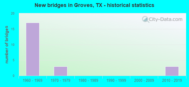
- New bridges - historical statistics
- 171960-1969
- 31970-1979
- 32010-2019
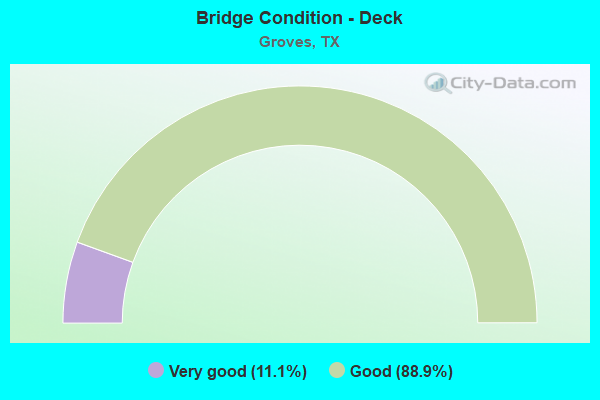
- Bridge Condition - Deck
- 11.1%Very good
- 88.9%Good
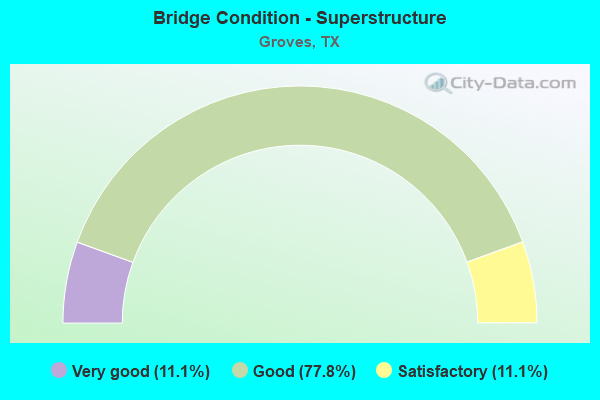
- Bridge Condition - Superstructure
- 11.1%Very good
- 77.8%Good
- 11.1%Satisfactory
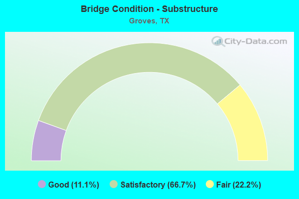
- Bridge Condition - Substructure
- 11.1%Good
- 66.7%Satisfactory
- 22.2%Fair
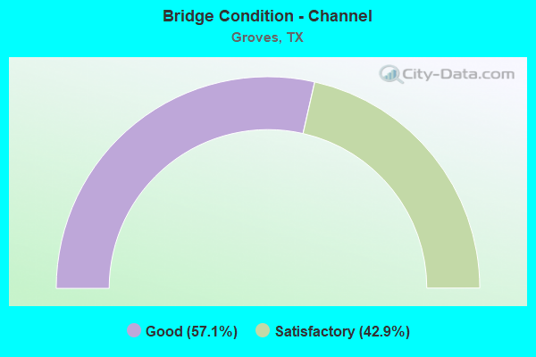
- Bridge Condition - Channel
- 57.1%Good
- 42.9%Satisfactory
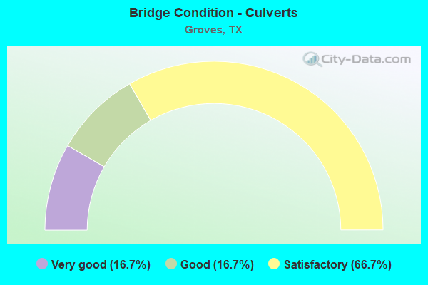
- Bridge Condition - Culverts
- 16.7%Very good
- 16.7%Good
- 66.7%Satisfactory
Find on map >> Show street view
Structure Number: 201240030603239, Location: 0.1 Mi S of SH 73 (Lat: 29.939319, Lng: -93.894964), Route carried "on" structure: ServiceState highway 87, Year Built: 2015, Status: Open, Structure Length: 1.13m (3.71ft), Average Daily Traffic: 24,250 (year 2011), Truck Traffic: 6%, Average Future Daily Traffic: 33,950 (year 2031), Design Load: HL 93, Features Intersected: CRANE BAYOU
Minimum Vertical Clearance: 30+ m (98+ ft), Kilometerpoint: 7.237, Lanes on structure: 2, Owner: State Highway Agency, Approaching Roadway Width: 7.3m (24.0ft), Skew: 1 degrees, Material/Design: Concrete, Design/Construction: Culvert, Number Of Spans In Main Unit: 3, Length of Maximum Span: 2.1m (6.9ft), Curb-To-Curb Width: 9.8m (32.2ft), Out-to-Out Width: 14.6m (47.9ft)
Condition: Channel: Good, Culverts: Good, Operating Rating: 54.4 metric tons, Method Used To Determine Operating Rating: Assigned ratings based on Load and Resistance Factor Design (LRFD) reported in metric tons, Inventory Rating: 32.7 metric tons, Method Used To Determine Inventory Rating: Assigned ratings based on Load and Resistance Factor Design (LRFD) reported in metric tons, Structural Evaluation: Better than present minimum criteria, Deck Geometry: Meets minimum limits, Waterway Adequacy: Equal to present desirable criteria, Approach Roadway Alignment: Somewhat better than minimum adequacy, Designated Inspection Frequency: Every 24 months, Inspection Date: July 2020, Deck Structure Type: Concrete Precast Panels, Wearing Surface/Protective System: Wearing Surface: Monolithic Concrete
Find on map >> Show street view
Structure Number: 20124003060324, Location: 0.1 Mi S of SH 73 (Lat: 29.939319, Lng: -93.894425), Route carried "on" structure: State highway 87, Year Built: 2015, Status: Open, Structure Length: 3.81m (12.50ft), Average Daily Traffic: 24,250 (year 2011), Truck Traffic: 6%, Average Future Daily Traffic: 33,950 (year 2031), Design Load: HL 93, Features Intersected: CRANE BAYOU
Minimum Vertical Clearance: 30+ m (98+ ft), Kilometerpoint: 7.237, Lanes on structure: 2, Owner: State Highway Agency, Approaching Roadway Width: 11.4m (37.4ft), Skew: 3 degrees, Material/Design: Prestressed concrete, Design/Construction: Stringer/Multi-beam, Number Of Spans In Main Unit: 3, Length of Maximum Span: 21.3m (69.9ft), Curb-To-Curb Width: 11.4m (37.4ft), Out-to-Out Width: 12.2m (40.0ft)
Condition: Deck: Very good, Superstructure: Very good, Substructure: Good, Channel: Good, Operating Rating: 54.4 metric tons, Method Used To Determine Operating Rating: Assigned ratings based on Load and Resistance Factor Design (LRFD) reported in metric tons, Inventory Rating: 32.7 metric tons, Method Used To Determine Inventory Rating: Assigned ratings based on Load and Resistance Factor Design (LRFD) reported in metric tons, Structural Evaluation: Better than present minimum criteria, Deck Geometry: Equal to present minimum criteria, Waterway Adequacy: Superior to present desirable criteria, Approach Roadway Alignment: Equal to present desirable criteria, Designated Inspection Frequency: Every 24 months, Inspection Date: July 2020, Deck Structure Type: Concrete Precast Panels, Wearing Surface/Protective System: Deck Protection: Epoxy Coated Reinforcing
Find on map >> Show street view
Structure Number: 201240050804165, Location: 0.2 MI W OF SH 87 (Lat: 29.940425, Lng: -93.896631), Route carried "on" structure: State highway 73, Year Built: 1961, Status: Open, Structure Length: 1.52m (4.99ft), Average Daily Traffic: 18,685 (year 2020), Truck Traffic: 9%, Average Future Daily Traffic: 28,580 (year 2033), Design Load: H 20, Features Intersected: Crane Bayou
Minimum Vertical Clearance: 30+ m (98+ ft), Kilometerpoint: 51.423, Lanes on structure: 9, Owner: State Highway Agency, Approaching Roadway Width: 40.5m (132.9ft), Skew: 25 degrees, Material/Design: Concrete, Design/Construction: Culvert, Number Of Spans In Main Unit: 3, Length of Maximum Span: 3.0m (9.8ft)
Condition: Channel: Good, Culverts: Satisfactory, Operating Rating: 32.7 metric tons, Method Used To Determine Operating Rating: Field evaluation and documented engineering judgment, Inventory Rating: 24.5 metric tons, Method Used To Determine Inventory Rating: Field evaluation and documented engineering judgment, Structural Evaluation: Equal to present minimum criteria, Waterway Adequacy: Equal to present minimum criteria, Approach Roadway Alignment: Equal to present desirable criteria, Length Of Structure Improvement: 2.26m (7.41ft), Designated Inspection Frequency: Every 24 months, Inspection Date: July 2020, Bridge Improvement Cost: $178,000, Roadway Improvement Cost: $45,000, Total Project Cost: $223,000
Find on map >> Show street view
Structure Number: 201240050804225, Location: 0.60 MI E OF SH 347 (Lat: 29.940667, Lng: -93.924292), Route carried "on" structure: State highway 73, Year Built: 1969, Status: Open, Structure Length: 12.22m (40.09ft), Average Daily Traffic: 16,145 (year 2018), Truck Traffic: 5%, Average Future Daily Traffic: 22,605 (year 2038), Design Load: HS 20, Features Intersected: 39TH ST
Minimum Vertical Clearance: 30+ m (98+ ft), Kilometerpoint: 48.744, Lanes on structure: 2, Lanes under structure: 6, Owner: State Highway Agency, Approaching Roadway Width: 11.6m (38.1ft), Skew: 5 degrees, Material/Design: Prestressed concrete, Design/Construction: Stringer/Multi-beam, Number Of Spans In Main Unit: 4, Number Of Approach Spans: 2, Length of Maximum Span: 24.4m (80.1ft), Curb-To-Curb Width: 12.4m (40.7ft), Out-to-Out Width: 12.9m (42.3ft)
Condition: Deck: Good, Superstructure: Good, Substructure: Satisfactory, Operating Rating: 55.3 metric tons, Method Used To Determine Operating Rating: Load Factor (LF), Inventory Rating: 32.7 metric tons, Method Used To Determine Inventory Rating: Load Factor (LF), Structural Evaluation: Equal to present minimum criteria, Deck Geometry: Better than present minimum criteria, Underclear: Meets minimum limits, Approach Roadway Alignment: Equal to present desirable criteria, Designated Inspection Frequency: Every 24 months, Inspection Date: July 2020, Deck Structure Type: Concrete Cast-file-Place, Wearing Surface/Protective System: Wearing Surface: Bituminous
Find on map >> Show street view
Structure Number: 201240050804226, Location: 0.60 MI E OF SH 347 (Lat: 29.940922, Lng: -93.924072), Route carried "on" structure: State highway 73, Year Built: 1969, Status: Open, Structure Length: 11.58m (37.99ft), Average Daily Traffic: 16,146 (year 2018), Truck Traffic: 5%, Average Future Daily Traffic: 22,605 (year 2038), Design Load: HS 20, Features Intersected: 39TH ST
Minimum Vertical Clearance: 30+ m (98+ ft), Kilometerpoint: 48.705, Lanes on structure: 2, Lanes under structure: 6, Owner: State Highway Agency, Approaching Roadway Width: 11.6m (38.1ft), Skew: 5 degrees, Material/Design: Prestressed concrete, Design/Construction: Stringer/Multi-beam, Number Of Spans In Main Unit: 4, Number Of Approach Spans: 2, Length of Maximum Span: 24.4m (80.1ft), Curb-To-Curb Width: 12.4m (40.7ft), Out-to-Out Width: 12.9m (42.3ft)
Condition: Deck: Good, Superstructure: Good, Substructure: Satisfactory, Operating Rating: 54.4 metric tons, Method Used To Determine Operating Rating: Load Factor (LF), Inventory Rating: 32.7 metric tons, Method Used To Determine Inventory Rating: Load Factor (LF), Structural Evaluation: Equal to present minimum criteria, Deck Geometry: Better than present minimum criteria, Underclear: Meets minimum limits, Approach Roadway Alignment: Equal to present desirable criteria, Designated Inspection Frequency: Every 24 months, Inspection Date: July 2020, Deck Structure Type: Concrete Cast-file-Place, Wearing Surface/Protective System: Wearing Surface: Bituminous
Find on map >> Show street view
Structure Number: 201240050804227, Location: 1.20 MI E OF SH 347 (Lat: 29.940675, Lng: -93.914836), Route carried "on" structure: State highway 73, Year Built: 1969, Status: Open, Structure Length: 5.79m (19.00ft), Average Daily Traffic: 9,258 (year 2020), Truck Traffic: 5%, Average Future Daily Traffic: 18,683 (year 2038), Design Load: HS 20, Features Intersected: WEST CROSS-OVER
Minimum Vertical Clearance: 30+ m (98+ ft), Kilometerpoint: 49.671, Lanes on structure: 3, Lanes under structure: 4, Owner: State Highway Agency, Approaching Roadway Width: 14.0m (45.9ft), Material/Design: Prestressed concrete, Design/Construction: Stringer/Multi-beam, Number Of Spans In Main Unit: 4, Length of Maximum Span: 16.8m (55.1ft), Curb-To-Curb Width: 14.8m (48.6ft), Out-to-Out Width: 15.3m (50.2ft)
Condition: Deck: Good, Superstructure: Good, Substructure: Satisfactory, Operating Rating: 47.2 metric tons, Method Used To Determine Operating Rating: Load Factor (LF), Inventory Rating: 28.1 metric tons, Method Used To Determine Inventory Rating: Load Factor (LF), Structural Evaluation: Equal to present minimum criteria, Deck Geometry: Meets minimum limits, Underclear: Meets minimum limits, Approach Roadway Alignment: Equal to present desirable criteria, Designated Inspection Frequency: Every 24 months, Inspection Date: July 2020, Deck Structure Type: Concrete Cast-file-Place, Wearing Surface/Protective System: Wearing Surface: Bituminous
Find on map >> Show street view
Structure Number: 201240050804228, Location: 1.20 MI E OF SH 347 (Lat: 29.940892, Lng: -93.914806), Route carried "on" structure: State highway 73, Year Built: 1969, Status: Open, Structure Length: 5.79m (19.00ft), Average Daily Traffic: 9,426 (year 2020), Truck Traffic: 5%, Average Future Daily Traffic: 18,683 (year 2038), Design Load: HS 20, Features Intersected: WEST CROSS-OVER
Minimum Vertical Clearance: 30+ m (98+ ft), Kilometerpoint: 49.672, Lanes on structure: 3, Lanes under structure: 4, Owner: State Highway Agency, Approaching Roadway Width: 14.0m (45.9ft), Material/Design: Prestressed concrete, Design/Construction: Stringer/Multi-beam, Number Of Spans In Main Unit: 4, Length of Maximum Span: 16.8m (55.1ft), Curb-To-Curb Width: 14.8m (48.6ft), Out-to-Out Width: 15.3m (50.2ft)
Condition: Deck: Good, Superstructure: Good, Substructure: Fair, Operating Rating: 47.2 metric tons, Method Used To Determine Operating Rating: Assigned ratings based on Allowable Stress Design (ASD) reported in metric tons, Inventory Rating: 28.1 metric tons, Method Used To Determine Inventory Rating: Assigned ratings based on Allowable Stress Design (ASD) reported in metric tons, Structural Evaluation: Somewhat better than minimum adequacy, Deck Geometry: Meets minimum limits, Underclear: Meets minimum limits, Approach Roadway Alignment: Equal to present desirable criteria, Designated Inspection Frequency: Every 24 months, Inspection Date: July 2020, Deck Structure Type: Concrete Cast-file-Place, Wearing Surface/Protective System: Wearing Surface: Bituminous
Find on map >> Show street view
Structure Number: 201240050804229, Location: 1.3 MI E OF SH 347 (Lat: 29.940600, Lng: -93.913231), Route carried "on" structure: State highway 73, Year Built: 1969, Status: Open, Structure Length: 5.79m (19.00ft), Average Daily Traffic: 9,258 (year 2020), Truck Traffic: 5%, Average Future Daily Traffic: 18,683 (year 2038), Design Load: HS 20, Features Intersected: EAST CROSS-OVER
Minimum Vertical Clearance: 30+ m (98+ ft), Kilometerpoint: 49.857, Lanes on structure: 3, Lanes under structure: 4, Owner: State Highway Agency, Approaching Roadway Width: 14.0m (45.9ft), Material/Design: Prestressed concrete, Design/Construction: Stringer/Multi-beam, Number Of Spans In Main Unit: 4, Length of Maximum Span: 16.8m (55.1ft), Curb-To-Curb Width: 14.8m (48.6ft), Out-to-Out Width: 15.3m (50.2ft)
Condition: Deck: Good, Superstructure: Satisfactory, Substructure: Fair, Operating Rating: 47.2 metric tons, Method Used To Determine Operating Rating: Load Factor (LF), Inventory Rating: 28.1 metric tons, Method Used To Determine Inventory Rating: Load Factor (LF), Structural Evaluation: Somewhat better than minimum adequacy, Deck Geometry: Meets minimum limits, Underclear: Meets minimum limits, Approach Roadway Alignment: Equal to present desirable criteria, Designated Inspection Frequency: Every 24 months, Inspection Date: July 2020, Deck Structure Type: Concrete Cast-file-Place, Wearing Surface/Protective System: Wearing Surface: Bituminous
Find on map >> Show street view
Structure Number: 20124005080423, Location: 1.3 MI E OF SH 347 (Lat: 29.940789, Lng: -93.912531), Route carried "on" structure: State highway 73, Year Built: 1969, Status: Open, Structure Length: 5.79m (19.00ft), Average Daily Traffic: 9,426 (year 2020), Truck Traffic: 5%, Average Future Daily Traffic: 14,683 (year 2038), Design Load: HS 20, Features Intersected: EAST CROSS-OVER
Minimum Vertical Clearance: 30+ m (98+ ft), Kilometerpoint: 49.859, Lanes on structure: 3, Lanes under structure: 4, Owner: State Highway Agency, Approaching Roadway Width: 14.0m (45.9ft), Material/Design: Prestressed concrete, Design/Construction: Stringer/Multi-beam, Number Of Spans In Main Unit: 4, Length of Maximum Span: 16.8m (55.1ft), Curb-To-Curb Width: 14.8m (48.6ft), Out-to-Out Width: 15.3m (50.2ft)
Condition: Deck: Good, Superstructure: Good, Substructure: Satisfactory, Operating Rating: 47.2 metric tons, Method Used To Determine Operating Rating: Load Factor (LF), Inventory Rating: 28.1 metric tons, Method Used To Determine Inventory Rating: Load Factor (LF), Structural Evaluation: Equal to present minimum criteria, Deck Geometry: Meets minimum limits, Underclear: Meets minimum limits, Approach Roadway Alignment: Equal to present desirable criteria, Designated Inspection Frequency: Every 24 months, Inspection Date: July 2020, Deck Structure Type: Concrete Cast-file-Place, Wearing Surface/Protective System: Wearing Surface: Bituminous
Find on map >> Show street view
Structure Number: 201240050804231, Location: 1.9 MI E OF SH 347 (Lat: 29.940492, Lng: -93.903461), Route carried "on" structure: State highway 73, Year Built: 1969, Status: Open, Structure Length: 9.75m (31.99ft), Average Daily Traffic: 9,258 (year 2020), Truck Traffic: 5%, Average Future Daily Traffic: 18,683 (year 2038), Design Load: HS 20, Features Intersected: 25TH ST
Minimum Vertical Clearance: 30+ m (98+ ft), Kilometerpoint: 50.810, Lanes on structure: 3, Lanes under structure: 6, Owner: State Highway Agency, Approaching Roadway Width: 14.0m (45.9ft), Skew: 3 degrees, Material/Design: Prestressed concrete, Design/Construction: Stringer/Multi-beam, Number Of Spans In Main Unit: 6, Length of Maximum Span: 16.8m (55.1ft), Curb-To-Curb Width: 14.8m (48.6ft), Out-to-Out Width: 15.3m (50.2ft)
Condition: Deck: Good, Superstructure: Good, Substructure: Satisfactory, Operating Rating: 54.4 metric tons, Method Used To Determine Operating Rating: Load Factor (LF), Inventory Rating: 32.7 metric tons, Method Used To Determine Inventory Rating: Load Factor (LF), Structural Evaluation: Equal to present minimum criteria, Deck Geometry: Meets minimum limits, Underclear: Meets minimum limits, Approach Roadway Alignment: Equal to present desirable criteria, Length Of Structure Improvement: 9.75m (31.99ft), Designated Inspection Frequency: Every 24 months, Inspection Date: July 2020, Deck Structure Type: Concrete Cast-file-Place, Wearing Surface/Protective System: Wearing Surface: Bituminous
Find on map >> Show street view
Structure Number: 201240050804232, Location: 1.9 MI E OF SH 347 (Lat: 29.940689, Lng: -93.902450), Route carried "on" structure: State highway 73, Year Built: 1969, Status: Open, Structure Length: 9.75m (31.99ft), Average Daily Traffic: 9,426 (year 2020), Truck Traffic: 9%, Average Future Daily Traffic: 14,290 (year 2033), Design Load: HS 20, Features Intersected: 25TH ST
Minimum Vertical Clearance: 30+ m (98+ ft), Kilometerpoint: 50.793, Lanes on structure: 2, Lanes under structure: 6, Owner: State Highway Agency, Approaching Roadway Width: 11.6m (38.1ft), Skew: 3 degrees, Material/Design: Prestressed concrete, Design/Construction: Stringer/Multi-beam, Number Of Spans In Main Unit: 6, Length of Maximum Span: 16.8m (55.1ft), Curb-To-Curb Width: 12.2m (40.0ft), Out-to-Out Width: 12.9m (42.3ft)
Condition: Deck: Good, Superstructure: Good, Substructure: Satisfactory, Operating Rating: 51.7 metric tons, Method Used To Determine Operating Rating: Load Factor (LF), Inventory Rating: 29.0 metric tons, Method Used To Determine Inventory Rating: Load Factor (LF), Structural Evaluation: Equal to present minimum criteria, Deck Geometry: Better than present minimum criteria, Underclear: High priority of corrective action, Approach Roadway Alignment: Equal to present desirable criteria, Designated Inspection Frequency: Every 24 months, Inspection Date: July 2020, Deck Structure Type: Concrete Cast-file-Place, Wearing Surface/Protective System: Wearing Surface: Bituminous
Find on map >> Show street view
Structure Number: 201240050804475, Location: 0.6 MI W OF SH 87 (Lat: 29.941225, Lng: -93.902394), Route carried "on" structure: ServiceState highway 73, Year Built: 2014, Status: Open, Structure Length: 1.07m (3.51ft), Average Daily Traffic: 1,870 (year 2011), Truck Traffic: 3%, Average Future Daily Traffic: 2,620 (year 2031), Design Load: HL 93, Features Intersected: CRANE BAYOU LATERAL, Facility Carried by Structure: 25TH STREET
Minimum Vertical Clearance: 30+ m (98+ ft), Kilometerpoint: 49.695, Lanes on structure: 4, Owner: State Highway Agency, Approaching Roadway Width: 14.0m (45.9ft), Skew: 23 degrees, Material/Design: Concrete, Design/Construction: Culvert, Number Of Spans In Main Unit: 3, Length of Maximum Span: 2.1m (6.9ft)
Condition: Channel: Good, Culverts: Very good, Operating Rating: 54.4 metric tons, Method Used To Determine Operating Rating: Assigned ratings based on Load and Resistance Factor Design (LRFD) reported in metric tons, Inventory Rating: 32.7 metric tons, Method Used To Determine Inventory Rating: Assigned ratings based on Load and Resistance Factor Design (LRFD) reported in metric tons, Structural Evaluation: Equal to present desirable criteria, Waterway Adequacy: Better than present minimum criteria, Approach Roadway Alignment: Equal to present desirable criteria, Designated Inspection Frequency: Every 48 months, Inspection Date: July 2020
Find on map >> Show street view
Structure Number: 201240C00311001, Location: .01MI. W. OF TAFT AVE. (Lat: 29.948508, Lng: -93.898244), Route carried "on" structure: City street , Year Built: 1970, Status: Open, Structure Length: 0.70m (2.30ft), Average Daily Traffic: 388 (year 2019), Truck Traffic: 3%, Average Future Daily Traffic: 388 (year 2039), Features Intersected: DRAINAGE DITCH, Facility Carried by Structure: DANE DR
Minimum Vertical Clearance: 30+ m (98+ ft), Kilometerpoint: 0.016, Lanes on structure: 2, Owner: City or Municipal Highway Agency, Approaching Roadway Width: 7.9m (25.9ft), Material/Design: Concrete, Design/Construction: Culvert, Number Of Spans In Main Unit: 3, Length of Maximum Span: 2.1m (6.9ft), Curb-To-Curb Width: 9.8m (32.2ft), Out-to-Out Width: 10.2m (33.5ft)
Condition: Channel: Satisfactory, Culverts: Satisfactory, Operating Rating: 32.7 metric tons, Method Used To Determine Operating Rating: Field evaluation and documented engineering judgment, Inventory Rating: 24.5 metric tons, Method Used To Determine Inventory Rating: Field evaluation and documented engineering judgment, Structural Evaluation: Equal to present minimum criteria, Deck Geometry: Better than present minimum criteria, Waterway Adequacy: Better than present minimum criteria, Approach Roadway Alignment: Equal to present desirable criteria, Designated Inspection Frequency: Every 24 months, Inspection Date: June 2021, Deck Structure Type: Concrete Cast-file-Place, Wearing Surface/Protective System: Wearing Surface: Bituminous
Find on map >> Show street view
Structure Number: 201240C01320002, Location: 0.4 MI NW OF SH 87 NB (Lat: 29.946622, Lng: -93.895647), Route carried "on" structure: City street , Year Built: 1970, Status: Open, Structure Length: 0.79m (2.59ft), Average Daily Traffic: 1,677 (year 2019), Average Future Daily Traffic: 2,350 (year 2039), Features Intersected: DRAINAGE DITCH, Facility Carried by Structure: TAFT ELEM-SE DRIVE
Minimum Vertical Clearance: 30+ m (98+ ft), Kilometerpoint: 0.644, Lanes on structure: 2, Owner: City or Municipal Highway Agency, Approaching Roadway Width: 10.4m (34.1ft), Material/Design: Concrete, Design/Construction: Culvert, Number Of Spans In Main Unit: 2, Length of Maximum Span: 3.7m (12.1ft), Curb-To-Curb Width: 10.4m (34.1ft), Out-to-Out Width: 10.6m (34.8ft)
Condition: Channel: Satisfactory, Culverts: Satisfactory, Operating Rating: 32.7 metric tons, Method Used To Determine Operating Rating: Field evaluation and documented engineering judgment, Inventory Rating: 24.5 metric tons, Method Used To Determine Inventory Rating: Field evaluation and documented engineering judgment, Structural Evaluation: Equal to present minimum criteria, Deck Geometry: Equal to present minimum criteria, Waterway Adequacy: Better than present minimum criteria, Approach Roadway Alignment: Equal to present desirable criteria, Designated Inspection Frequency: Every 24 months, Inspection Date: June 2021, Deck Structure Type: Concrete Cast-file-Place, Wearing Surface/Protective System: Wearing Surface: Bituminous
Find on map >> Show street view
Structure Number: 201240C01320003, Location: 0.5 MI NW OF SH 87 NB (Lat: 29.947275, Lng: -93.896567), Route carried "on" structure: City street , Year Built: 1970, Status: Open, Structure Length: 0.79m (2.59ft), Average Daily Traffic: 388 (year 2019), Truck Traffic: 3%, Average Future Daily Traffic: 388 (year 2039), Features Intersected: DRAINAGE DITCH, Facility Carried by Structure: TAFT ELEM-NW DRIVE
Minimum Vertical Clearance: 30+ m (98+ ft), Kilometerpoint: 0.805, Lanes on structure: 2, Owner: City or Municipal Highway Agency, Approaching Roadway Width: 7.3m (24.0ft), Material/Design: Concrete, Design/Construction: Culvert, Number Of Spans In Main Unit: 2, Length of Maximum Span: 3.7m (12.1ft), Curb or Sidewalk Widths: Left: 1.5m (4.9ft), Right: 1.5m (4.9ft), Curb-To-Curb Width: 7.3m (24.0ft), Out-to-Out Width: 10.6m (34.8ft)
Condition: Channel: Satisfactory, Culverts: Satisfactory, Operating Rating: 32.7 metric tons, Method Used To Determine Operating Rating: Field evaluation and documented engineering judgment, Inventory Rating: 24.5 metric tons, Method Used To Determine Inventory Rating: Field evaluation and documented engineering judgment, Structural Evaluation: Equal to present minimum criteria, Deck Geometry: High priority of replacement, Waterway Adequacy: Better than present minimum criteria, Approach Roadway Alignment: Equal to present desirable criteria, Length Of Structure Improvement: 0.79m (2.59ft), Designated Inspection Frequency: Every 24 months, Inspection Date: June 2021, Bridge Improvement Cost: $1,000, Total Project Cost: $1,000, Deck Structure Type: Concrete Cast-file-Place, Wearing Surface/Protective System: Wearing Surface: Bituminous
Find on map >> Show street view
Structure Number: 201240050804225, Location: 0.60 MI E OF SH 347 (Lat: 29.940667, Lng: -93.924292), Route carried "under" structure: State highway 73, Year Built: 1969, Structure Length: 0. m, Average Daily Traffic: 4,199 (year 2018), Truck Traffic: 3%, Features Intersected: 39TH ST
Minimum Vertical Clearance: 4.80m (15.75ft), Kilometerpoint: 48.638, Lanes on structure: 2, Lanes under structure: 6, Material/Design: Prestressed concrete, Design/Construction: Stringer/Multi-beam, Length of Maximum Span: 24.4m (80.1ft)
Find on map >> Show street view
Structure Number: 201240050804226, Location: 0.60 MI E OF SH 347 (Lat: 29.940922, Lng: -93.924072), Route carried "under" structure: State highway 73, Year Built: 1969, Structure Length: 0. m, Average Daily Traffic: 4,199 (year 2018), Truck Traffic: 3%, Features Intersected: 39TH ST
Minimum Vertical Clearance: 5.13m (16.83ft), Kilometerpoint: 48.618, Lanes on structure: 2, Lanes under structure: 6, Material/Design: Prestressed concrete, Design/Construction: Stringer/Multi-beam, Length of Maximum Span: 24.4m (80.1ft)
Find on map >> Show street view
Structure Number: 201240050804227, Location: 1.20 MI E OF SH 347 (Lat: 29.940675, Lng: -93.914836), Route carried "under" structure: State highway 73, Year Built: 1969, Structure Length: 0. m, Average Daily Traffic: 3,108 (year 2018), Truck Traffic: 2%, Features Intersected: WEST CROSS-OVER
Minimum Vertical Clearance: 4.47m (14.67ft), Kilometerpoint: 49.577, Lanes on structure: 3, Lanes under structure: 4, Material/Design: Prestressed concrete, Design/Construction: Stringer/Multi-beam, Length of Maximum Span: 16.8m (55.1ft)
Find on map >> Show street view
Structure Number: 201240050804228, Location: 1.20 MI E OF SH 347 (Lat: 29.940892, Lng: -93.914806), Route carried "under" structure: State highway 73, Year Built: 1969, Structure Length: 0. m, Average Daily Traffic: 3,108 (year 2018), Truck Traffic: 2%, Features Intersected: WEST CROSS-OVER
Minimum Vertical Clearance: 4.70m (15.42ft), Kilometerpoint: 49.577, Lanes on structure: 3, Lanes under structure: 4, Material/Design: Prestressed concrete, Design/Construction: Stringer/Multi-beam, Length of Maximum Span: 16.8m (55.1ft)
Find on map >> Show street view
Structure Number: 201240050804229, Location: 1.3 MI E OF SH 347 (Lat: 29.940758, Lng: -93.912958), Route carried "under" structure: State highway 73, Year Built: 1969, Structure Length: 0. m, Average Daily Traffic: 5,378 (year 2018), Truck Traffic: 2%, Features Intersected: EAST CROSS-OVER
Minimum Vertical Clearance: 4.70m (15.42ft), Kilometerpoint: 49.763, Lanes on structure: 3, Lanes under structure: 4, Material/Design: Prestressed concrete, Design/Construction: Stringer/Multi-beam, Length of Maximum Span: 16.8m (55.1ft)
Find on map >> Show street view
Structure Number: 20124005080423, Location: 1.3 MI E OF SH 347 (Lat: 29.940561, Lng: -93.912850), Route carried "under" structure: State highway 73, Year Built: 1969, Structure Length: 0. m, Average Daily Traffic: 5,378 (year 2018), Truck Traffic: 2%, Features Intersected: EAST CROSS-OVER
Minimum Vertical Clearance: 4.70m (15.42ft), Kilometerpoint: 49.763, Lanes on structure: 3, Lanes under structure: 4, Material/Design: Prestressed concrete, Design/Construction: Stringer/Multi-beam, Length of Maximum Span: 16.8m (55.1ft)
Find on map >> Show street view
Structure Number: 201240050804231, Location: 1.9 MI E OF SH 347 (Lat: 29.940492, Lng: -93.903461), Route carried "under" structure: State highway 73, Year Built: 1969, Structure Length: 0. m, Average Daily Traffic: 3,991 (year 2018), Truck Traffic: 3%, Features Intersected: 25TH ST
Minimum Vertical Clearance: 4.78m (15.68ft), Kilometerpoint: 50.712, Lanes on structure: 3, Lanes under structure: 6, Material/Design: Prestressed concrete, Design/Construction: Stringer/Multi-beam, Length of Maximum Span: 16.8m (55.1ft)
Find on map >> Show street view
Structure Number: 201240050804232, Location: 1.9 MI E OF SH 347 (Lat: 29.940689, Lng: -93.902450), Route carried "under" structure: State highway 73, Year Built: 1969, Structure Length: 0. m, Average Daily Traffic: 12,420 (year 2010), Truck Traffic: 9%, Features Intersected: 25TH ST
Minimum Vertical Clearance: 4.85m (15.91ft), Kilometerpoint: 50.710, Lanes on structure: 2, Lanes under structure: 6, Material/Design: Prestressed concrete, Design/Construction: Stringer/Multi-beam, Length of Maximum Span: 16.8m (55.1ft)