Bridge Statistics for Grovetown, Georgia (GA)
Condition, Traffic, Stress, Structural Evaluation, Project Costs
- National Bridge Inventory (NBI) Statistics
- 17Number of bridges
- 194ft / 59.3mTotal length
- $12,462,000Total costs
- 262,865Total average daily traffic
- 19,154Total average daily truck traffic
- National Bridge Inventory (NBI) Registered Bridges for Grovetown
- No street view available for this location
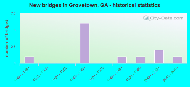
- New bridges - historical statistics
- 11930-1939
- 61960-1969
- 11980-1989
- 11990-1999
- 22000-2009
- 12010-2019
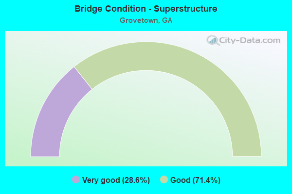
- Bridge Condition - Superstructure
- 28.6%Very good
- 71.4%Good
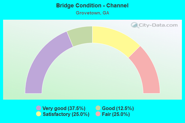
- Bridge Condition - Channel
- 37.5%Very good
- 12.5%Good
- 25.0%Satisfactory
- 25.0%Fair
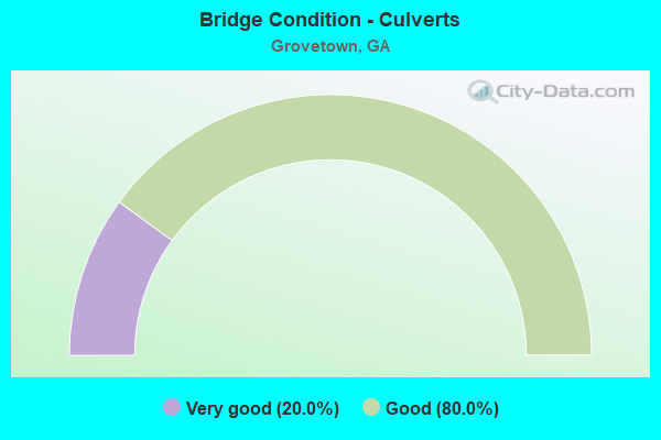
- Bridge Condition - Culverts
- 20.0%Very good
- 80.0%Good
Find on map >> Show street view
Structure Number: 730017, Location: 4.6 MI NE OF HARLEM (Lat: 33.476439, Lng: -82.280139), Route carried "on" structure: State highway 223, Year Built: 1934, Status: Open, Structure Length: 0.64m (2.10ft), Average Daily Traffic: 2,590 (year 2012), Truck Traffic: 1%, Average Future Daily Traffic: 3,885 (year 2032), Design Load: H 15, Features Intersected: LITTLE KIOKEE CREEK
Minimum Vertical Clearance: 30+ m (98+ ft), Kilometerpoint: 11.265, Lanes on structure: 2, Base Highway Network: Yes, Owner: State Highway Agency, Approaching Roadway Width: 8.8m (28.9ft), Material/Design: Concrete, Design/Construction: Culvert, Number Of Spans In Main Unit: 2, Length of Maximum Span: 3.0m (9.8ft)
Condition: Channel: Satisfactory, Culverts: Good, Operating Rating: 41.7 metric tons, Method Used To Determine Operating Rating: Field evaluation and documented engineering judgment, Inventory Rating: 24.4 metric tons, Method Used To Determine Inventory Rating: Field evaluation and documented engineering judgment, Structural Evaluation: Equal to present minimum criteria, Waterway Adequacy: Equal to present desirable criteria, Approach Roadway Alignment: Equal to present desirable criteria, Designated Inspection Frequency: Every 24 months, Inspection Date: June 2021, Bridge Improvement Cost: $82,000, Roadway Improvement Cost: $8,000, Total Project Cost: $123,000
Find on map >> Show street view
Structure Number: 730025, Location: 1.2 MI N OF SR-223 (Lat: 33.485008, Lng: -82.214228), Route carried "on" structure: County highway 238, Year Built: 1966, Status: Open, Structure Length: 8.26m (27.10ft), Average Daily Traffic: 490 (year 2012), Truck Traffic: 1%, Average Future Daily Traffic: 735 (year 2032), Design Load: H 15, Features Intersected: I-20, Facility Carried by Structure: CHAMBLIN ROAD
Minimum Vertical Clearance: 30+ m (98+ ft), Kilometerpoint: 3.219, Lanes on structure: 2, Lanes under structure: 4, Base Highway Network: Yes, Owner: State Highway Agency, Approaching Roadway Width: 6.4m (21.0ft), Skew: 2 degrees, Material/Design: Steel continuous, Design/Construction: Stringer/Multi-beam, Number Of Spans In Main Unit: 4, Length of Maximum Span: 23.8m (78.1ft), Curb or Sidewalk Widths: Left: 0.6m (2.0ft), Right: 0.6m (2.0ft), Curb-To-Curb Width: 7.3m (24.0ft), Out-to-Out Width: 9.1m (29.9ft)
Condition: Deck: Good, Superstructure: Good, Substructure: Good, Operating Rating: 36.2 metric tons, Method Used To Determine Operating Rating: Load Factor (LF), Inventory Rating: 21.7 metric tons, Method Used To Determine Inventory Rating: Load Factor (LF), Structural Evaluation: Equal to present minimum criteria, Deck Geometry: Meets minimum limits, Underclear: Meets minimum limits, Approach Roadway Alignment: Equal to present minimum criteria, Length Of Structure Improvement: 48.49m (159.09ft), Designated Inspection Frequency: Every 24 months, Inspection Date: June 2021, Bridge Improvement Cost: $1,059,000, Roadway Improvement Cost: $106,000, Total Project Cost: $1,588,000, Deck Structure Type: Concrete Cast-file-Place
Find on map >> Show street view
Structure Number: 730026, Location: 1.3 MI N OF SR-223 (Lat: 33.488569, Lng: -82.245197), Route carried "on" structure: County highway 253, Year Built: 1966, Status: Open, Structure Length: 7.59m (24.90ft), Average Daily Traffic: 490 (year 2012), Truck Traffic: 5%, Average Future Daily Traffic: 735 (year 2032), Design Load: H 15, Features Intersected: I-20 & OFF RAMP FOR WS, Facility Carried by Structure: BAKER PLACE ROAD
Minimum Vertical Clearance: 30+ m (98+ ft), Kilometerpoint: 1.609, Lanes on structure: 2, Lanes under structure: 5, Base Highway Network: Yes, Owner: State Highway Agency, Approaching Roadway Width: 6.1m (20.0ft), Material/Design: Steel continuous, Design/Construction: Stringer/Multi-beam, Number Of Spans In Main Unit: 4, Length of Maximum Span: 21.6m (70.9ft), Curb or Sidewalk Widths: Left: 0.6m (2.0ft), Right: 0.6m (2.0ft), Curb-To-Curb Width: 7.3m (24.0ft), Out-to-Out Width: 9.2m (30.2ft)
Condition: Deck: Good, Superstructure: Good, Substructure: Good, Operating Rating: 29.9 metric tons, Method Used To Determine Operating Rating: Load Factor (LF), Inventory Rating: 18.1 metric tons, Method Used To Determine Inventory Rating: Load Factor (LF), Structural Evaluation: Somewhat better than minimum adequacy, Deck Geometry: Meets minimum limits, Underclear: High priority of corrective action, Approach Roadway Alignment: Meets minimum limits, Designated Inspection Frequency: Every 24 months, Inspection Date: June 2021, Bridge Improvement Cost: $973,000, Roadway Improvement Cost: $97,000, Total Project Cost: $1,459,000, Deck Structure Type: Concrete Cast-file-Place
Find on map >> Show street view
Structure Number: 730032, Location: 2.7 MI NW OF GROVETOWN (Lat: 33.485769, Lng: -82.222319), Route carried "on" structure: Interstate 20, Year Built: 1966, Status: Open, Structure Length: 6.40m (21.00ft), Average Daily Traffic: 37,890 (year 2012), Truck Traffic: 1%, Average Future Daily Traffic: 56,835 (year 2032), Design Load: HS 20+Mod, Features Intersected: UCHEE CREEK
Minimum Vertical Clearance: 30+ m (98+ ft), Kilometerpoint: 302.557, Lanes on structure: 2, Base Highway Network: Yes, Owner: State Highway Agency, Approaching Roadway Width: 11.9m (39.0ft), Skew: 10 degrees, Material/Design: Concrete, Design/Construction: Tee Beam, Number Of Spans In Main Unit: 6, Length of Maximum Span: 10.7m (35.1ft), Curb-To-Curb Width: 11.6m (38.1ft), Out-to-Out Width: 12.2m (40.0ft)
Condition: Deck: Good, Superstructure: Good, Substructure: Good, Channel: Fair, Operating Rating: 38.1 metric tons, Method Used To Determine Operating Rating: Load Factor (LF), Inventory Rating: 22.6 metric tons, Method Used To Determine Inventory Rating: Load Factor (LF), Structural Evaluation: Somewhat better than minimum adequacy, Deck Geometry: Equal to present minimum criteria, Waterway Adequacy: Equal to present desirable criteria, Approach Roadway Alignment: Equal to present desirable criteria, Designated Inspection Frequency: Every 24 months, Inspection Date: June 2021, Bridge Improvement Cost: $821,000, Roadway Improvement Cost: $82,000, Total Project Cost: $1,231,000, Deck Structure Type: Concrete Cast-file-Place
Find on map >> Show street view
Structure Number: 730033, Location: 2.7 MI NW OF GROVETOWN (Lat: 33.486011, Lng: -82.222258), Route carried "on" structure: Interstate 20, Year Built: 1966, Status: Open, Structure Length: 6.40m (21.00ft), Average Daily Traffic: 37,890 (year 2012), Truck Traffic: 1%, Average Future Daily Traffic: 56,835 (year 2032), Design Load: HS 20+Mod, Features Intersected: UCHEE CREEK
Minimum Vertical Clearance: 30+ m (98+ ft), Kilometerpoint: 302.557, Lanes on structure: 2, Base Highway Network: Yes, Owner: State Highway Agency, Approaching Roadway Width: 11.9m (39.0ft), Skew: 10 degrees, Material/Design: Concrete, Design/Construction: Tee Beam, Number Of Spans In Main Unit: 6, Length of Maximum Span: 10.7m (35.1ft), Curb-To-Curb Width: 11.6m (38.1ft), Out-to-Out Width: 12.2m (40.0ft)
Condition: Deck: Good, Superstructure: Good, Substructure: Good, Channel: Fair, Operating Rating: 37.1 metric tons, Method Used To Determine Operating Rating: Load Factor (LF), Inventory Rating: 21.7 metric tons, Method Used To Determine Inventory Rating: Load Factor (LF), Structural Evaluation: Somewhat better than minimum adequacy, Deck Geometry: Equal to present minimum criteria, Waterway Adequacy: Equal to present desirable criteria, Approach Roadway Alignment: Equal to present desirable criteria, Designated Inspection Frequency: Every 24 months, Inspection Date: June 2021, Bridge Improvement Cost: $821,000, Roadway Improvement Cost: $82,000, Total Project Cost: $1,231,000, Deck Structure Type: Concrete Cast-file-Place
Find on map >> Show street view
Structure Number: 730039, Location: 4.8 MI NW OF GROVETOWN (Lat: 33.486728, Lng: -82.271928), Route carried "on" structure: County highway 2122, Year Built: 1963, Status: Open, Structure Length: 0.98m (3.22ft), Average Daily Traffic: 1,520 (year 2012), Truck Traffic: 1%, Average Future Daily Traffic: 2,280 (year 2032), Design Load: H 15, Features Intersected: LITTLE KIOKEE CREEK, Facility Carried by Structure: LOUISVILLE ROAD
Minimum Vertical Clearance: 30+ m (98+ ft), Kilometerpoint: 6.437, Lanes on structure: 2, Base Highway Network: Yes, Owner: County Highway Agency, Approaching Roadway Width: 6.7m (22.0ft), Material/Design: Concrete, Design/Construction: Culvert, Number Of Spans In Main Unit: 3, Length of Maximum Span: 3.0m (9.8ft)
Condition: Channel: Satisfactory, Culverts: Good, Operating Rating: 41.7 metric tons, Method Used To Determine Operating Rating: Field evaluation and documented engineering judgment, Inventory Rating: 24.4 metric tons, Method Used To Determine Inventory Rating: Field evaluation and documented engineering judgment, Structural Evaluation: Equal to present minimum criteria, Waterway Adequacy: Equal to present desirable criteria, Approach Roadway Alignment: Equal to present desirable criteria, Designated Inspection Frequency: Every 24 months, Inspection Date: June 2021, Bridge Improvement Cost: $125,000, Roadway Improvement Cost: $13,000, Total Project Cost: $188,000
Find on map >> Show street view
Structure Number: 73004, Location: 5.2 MI NW OF GROVETOWN (Lat: 33.492128, Lng: -82.275647), Route carried "on" structure: County highway 2122, Year Built: 1966, Status: Open, Structure Length: 9.60m (31.50ft), Average Daily Traffic: 1,520 (year 2012), Truck Traffic: 1%, Average Future Daily Traffic: 2,280 (year 2032), Design Load: H 15, Features Intersected: I-20, Facility Carried by Structure: LOUISVILLE ROAD
Minimum Vertical Clearance: 30+ m (98+ ft), Kilometerpoint: 8.047, Lanes on structure: 2, Lanes under structure: 4, Base Highway Network: Yes, Owner: State Highway Agency, Approaching Roadway Width: 6.4m (21.0ft), Skew: 3 degrees, Material/Design: Steel continuous, Design/Construction: Stringer/Multi-beam, Number Of Spans In Main Unit: 4, Length of Maximum Span: 27.1m (88.9ft), Curb or Sidewalk Widths: Left: 0.6m (2.0ft), Right: 0.6m (2.0ft), Curb-To-Curb Width: 7.3m (24.0ft), Out-to-Out Width: 9.2m (30.2ft)
Condition: Deck: Good, Superstructure: Good, Substructure: Good, Operating Rating: 30.8 metric tons, Method Used To Determine Operating Rating: Load Factor (LF), Inventory Rating: 18.1 metric tons, Method Used To Determine Inventory Rating: Load Factor (LF), Structural Evaluation: Somewhat better than minimum adequacy, Deck Geometry: Meets minimum limits, Underclear: High priority of corrective action, Approach Roadway Alignment: Better than present minimum criteria, Length Of Structure Improvement: 49.83m (163.48ft), Designated Inspection Frequency: Every 24 months, Inspection Date: June 2021, Bridge Improvement Cost: $1,231,000, Roadway Improvement Cost: $123,000, Total Project Cost: $1,846,000, Deck Structure Type: Concrete Cast-file-Place
Find on map >> Show street view
Structure Number: 735007, Location: 3 MI NW OF GROVETOWN (Lat: 33.490747, Lng: -82.221808), Route carried "on" structure: County highway 238, Year Built: 1984, Status: Open, Structure Length: 1.31m (4.30ft), Average Daily Traffic: 490 (year 2012), Truck Traffic: 1%, Average Future Daily Traffic: 735 (year 2032), Design Load: HS 20+Mod, Features Intersected: UCHEE CREEK, Facility Carried by Structure: CHAMBLIN ROAD
Minimum Vertical Clearance: 30+ m (98+ ft), Kilometerpoint: 3.219, Lanes on structure: 2, Base Highway Network: Yes, Owner: County Highway Agency, Approaching Roadway Width: 6.4m (21.0ft), Material/Design: Concrete, Design/Construction: Culvert, Number Of Spans In Main Unit: 4, Length of Maximum Span: 3.0m (9.8ft)
Condition: Channel: Good, Culverts: Good, Operating Rating: 55.3 metric tons, Method Used To Determine Operating Rating: Field evaluation and documented engineering judgment, Inventory Rating: 32.6 metric tons, Method Used To Determine Inventory Rating: Field evaluation and documented engineering judgment, Structural Evaluation: Better than present minimum criteria, Waterway Adequacy: Better than present minimum criteria, Approach Roadway Alignment: Equal to present desirable criteria, Designated Inspection Frequency: Every 24 months, Inspection Date: June 2021, Bridge Improvement Cost: $168,000, Roadway Improvement Cost: $17,000, Total Project Cost: $252,000
Find on map >> Show street view
Structure Number: 735016, Location: 2 MI W OF GROVETOWN (Lat: 33.456369, Lng: -82.232917), Route carried "on" structure: County highway 2121, Year Built: 1996, Status: Open, Structure Length: 1.31m (4.30ft), Average Daily Traffic: 5,000 (year 2012), Truck Traffic: 1%, Average Future Daily Traffic: 7,500 (year 2032), Design Load: HS 20+Mod, Features Intersected: UCHEE CREEK, Facility Carried by Structure: HARLEM-GROVETOWN R
Minimum Vertical Clearance: 30+ m (98+ ft), Kilometerpoint: 9.656, Lanes on structure: 2, Base Highway Network: Yes, Owner: County Highway Agency, Approaching Roadway Width: 7.6m (24.9ft), Material/Design: Concrete, Design/Construction: Culvert, Number Of Spans In Main Unit: 4, Length of Maximum Span: 3.0m (9.8ft)
Condition: Channel: Very good, Culverts: Good, Structural Evaluation: Better than present minimum criteria, Waterway Adequacy: Equal to present desirable criteria, Approach Roadway Alignment: Equal to present desirable criteria, Designated Inspection Frequency: Every 24 months, Inspection Date: June 2021, Bridge Improvement Cost: $168,000, Roadway Improvement Cost: $17,000, Total Project Cost: $252,000
Find on map >> Show street view
Structure Number: 735019, Location: 2.1 MI NW OF GROVETOWN (Lat: 33.480839, Lng: -82.210889), Route carried "on" structure: County highway 1776, Year Built: 2006, Status: Open, Structure Length: 0.82m (2.69ft), Average Daily Traffic: 830 (year 2012), Truck Traffic: 1%, Average Future Daily Traffic: 1,245 (year 2032), Design Load: HS 20+Mod, Features Intersected: MILL BRANCH, Facility Carried by Structure: SAWMILL TRAIL
Minimum Vertical Clearance: 30+ m (98+ ft), Kilometerpoint: 0.000, Lanes on structure: 2, Base Highway Network: Yes, Owner: County Highway Agency, Approaching Roadway Width: 9.1m (29.9ft), Skew: 3 degrees, Material/Design: Concrete, Design/Construction: Culvert, Number Of Spans In Main Unit: 2, Length of Maximum Span: 4.0m (13.1ft)
Condition: Channel: Very good, Culverts: Very good, Operating Rating: 55.3 metric tons, Method Used To Determine Operating Rating: Field evaluation and documented engineering judgment, Inventory Rating: 32.6 metric tons, Method Used To Determine Inventory Rating: Field evaluation and documented engineering judgment, Structural Evaluation: Equal to present desirable criteria, Waterway Adequacy: Equal to present desirable criteria, Approach Roadway Alignment: Equal to present desirable criteria, Designated Inspection Frequency: Every 24 months, Inspection Date: June 2021, Bridge Improvement Cost: $105,000, Roadway Improvement Cost: $11,000, Total Project Cost: $158,000
Find on map >> Show street view
Structure Number: 735023, Location: 2.1 MI NORTH OF GROVETOWN (Lat: 33.483808, Lng: -82.199278), Route carried "on" structure: State highway 388, Year Built: 2009, Status: Open, Structure Length: 6.80m (22.31ft), Average Daily Traffic: 14,500 (year 2012), Truck Traffic: 1%, Average Future Daily Traffic: 21,750 (year 2032), Design Load: HS 20+Mod, Features Intersected: I-20, Facility Carried by Structure: LEWISTON ROAD
Minimum Vertical Clearance: 30+ m (98+ ft), Kilometerpoint: 4.828, Lanes on structure: 5, Lanes under structure: 4, Base Highway Network: Yes, Owner: State Highway Agency, Approaching Roadway Width: 9.1m (29.9ft), Skew: 1 degrees, Material/Design: Prestressed concrete, Design/Construction: Stringer/Multi-beam, Number Of Spans In Main Unit: 2, Length of Maximum Span: 34.1m (111.9ft), Curb or Sidewalk Widths: Left: 0.0m, Right: 1.8m (5.9ft), Curb-To-Curb Width: 26.4m (86.6ft), Out-to-Out Width: 29.0m (95.1ft)
Condition: Deck: Good, Superstructure: Very good, Substructure: Good, Operating Rating: 44.4 metric tons, Method Used To Determine Operating Rating: Load Factor (LF), Inventory Rating: 26.3 metric tons, Method Used To Determine Inventory Rating: Load Factor (LF), Structural Evaluation: Equal to present minimum criteria, Deck Geometry: Superior to present desirable criteria, Underclear: Better than present minimum criteria, Approach Roadway Alignment: Equal to present desirable criteria, Designated Inspection Frequency: Every 24 months, Inspection Date: June 2021, Bridge Improvement Cost: $1,584,000, Roadway Improvement Cost: $158,000, Total Project Cost: $2,376,000, Deck Structure Type: Concrete Cast-file-Place
Find on map >> Show street view
Structure Number: 735024, Location: 2.2 MI NW OF GROVETOWN (Lat: 33.466919, Lng: -82.232581), Route carried "on" structure: State highway 223, Year Built: 2011, Status: Open, Structure Length: 9.14m (29.99ft), Average Daily Traffic: 4,780 (year 2012), Truck Traffic: 1%, Average Future Daily Traffic: 7,170 (year 2032), Design Load: HS 20+Mod, Features Intersected: UCHEE CREEK
Minimum Vertical Clearance: 30+ m (98+ ft), Kilometerpoint: 16.093, Lanes on structure: 2, Base Highway Network: Yes, Owner: State Highway Agency, Approaching Roadway Width: 15.8m (51.8ft), Material/Design: Prestressed concrete, Design/Construction: Stringer/Multi-beam, Number Of Spans In Main Unit: 4, Length of Maximum Span: 22.9m (75.1ft), Curb-To-Curb Width: 13.4m (44.0ft), Out-to-Out Width: 14.4m (47.2ft)
Condition: Deck: Good, Superstructure: Very good, Substructure: Good, Channel: Very good, Operating Rating: 76.2 metric tons, Method Used To Determine Operating Rating: Load Factor (LF), Inventory Rating: 34.4 metric tons, Method Used To Determine Inventory Rating: Load Factor (LF), Structural Evaluation: Better than present minimum criteria, Deck Geometry: Better than present minimum criteria, Waterway Adequacy: Equal to present desirable criteria, Approach Roadway Alignment: Equal to present desirable criteria, Designated Inspection Frequency: Every 24 months, Inspection Date: June 2021, Bridge Improvement Cost: $1,172,000, Roadway Improvement Cost: $117,000, Total Project Cost: $1,758,000, Deck Structure Type: Concrete Cast-file-Place
Find on map >> Show street view
Structure Number: 730025, Location: 1.2 MI N OF SR-223 (Lat: 33.485008, Lng: -82.214228), Route carried "under" structure: Interstate 20, Structure Length: 0. m, Average Daily Traffic: 33,900 (year 2010), Truck Traffic: 15%, Features Intersected: CR 238 CHAMBLIN ROAD, Facility Carried by Structure: CHAMBLIN ROAD
Minimum Vertical Clearance: 5.53m (18.14ft), Kilometerpoint: 304.166, Lanes on structure: 2, Length of Maximum Span: 0.0m
Find on map >> Show street view
Structure Number: 730026, Location: 1.3 MI N OF SR-223 (Lat: 33.488569, Lng: -82.245197), Route carried "under" structure: Interstate 20, Structure Length: 0. m, Average Daily Traffic: 33,900 (year 2010), Truck Traffic: 15%, Features Intersected: CR253 BAKER PLACE CIRCLE, Facility Carried by Structure: BAKER PLACE ROAD
Minimum Vertical Clearance: 5.23m (17.16ft), Kilometerpoint: 300.947, Lanes on structure: 2, Length of Maximum Span: 0.0m
Find on map >> Show street view
Structure Number: 730026, Location: 1.3 MI N OF SR-223 (Lat: 33.488569, Lng: -82.245197), Route carried "under" structure: Ramp Interstate 20, Structure Length: 0. m, Average Daily Traffic: 8,475 (year 2004), Truck Traffic: 10%, Features Intersected: CR253 BAKER PLACE CIRCLE, Facility Carried by Structure: BAKER PLACE ROAD
Minimum Vertical Clearance: 5.05m (16.57ft), Kilometerpoint: 300.947, Lanes on structure: 2, Length of Maximum Span: 0.0m
Find on map >> Show street view
Structure Number: 73004, Location: 5.2 MI NW OF GROVETOWN (Lat: 33.492128, Lng: -82.275647), Route carried "under" structure: Interstate 20, Structure Length: 0. m, Average Daily Traffic: 33,900 (year 2010), Truck Traffic: 1%, Features Intersected: S-2122 LOUISVILLE ROAD, Facility Carried by Structure: LOUISVILLE ROAD
Minimum Vertical Clearance: 5.51m (18.08ft), Kilometerpoint: 297.729, Lanes on structure: 2, Length of Maximum Span: 0.0m
Find on map >> Show street view
Structure Number: 735023, Location: 2.1 MI NORTH OF GROVETOWN (Lat: 33.483808, Lng: -82.199278), Route carried "under" structure: Interstate 20, Structure Length: 0. m, Average Daily Traffic: 44,700 (year 2010), Truck Traffic: 15%, Features Intersected: SR 388 LEWISTON, Facility Carried by Structure: LEWISTON ROAD
Minimum Vertical Clearance: 5.48m (17.98ft), Kilometerpoint: 305.776, Lanes on structure: 5, Length of Maximum Span: 0.0m