Bridge Statistics for Guernsey, Wyoming (WY)
Condition, Traffic, Stress, Structural Evaluation, Project Costs
- National Bridge Inventory (NBI) Statistics
- 10Number of bridges
- 161ft / 49.1mTotal length
- $458,000Total costs
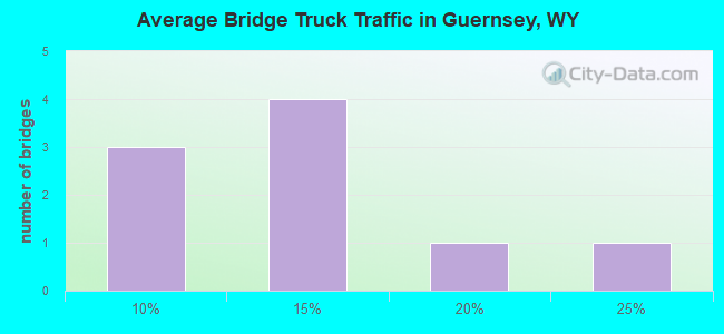
- 12,521Total average daily traffic
- 1,676Total average daily truck traffic
- National Bridge Inventory (NBI) Registered Bridges for Guernsey
- No street view available for this location
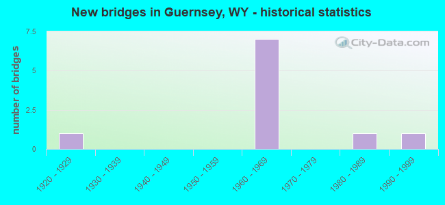
- New bridges - historical statistics
- 11920-1929
- 71960-1969
- 11980-1989
- 11990-1999
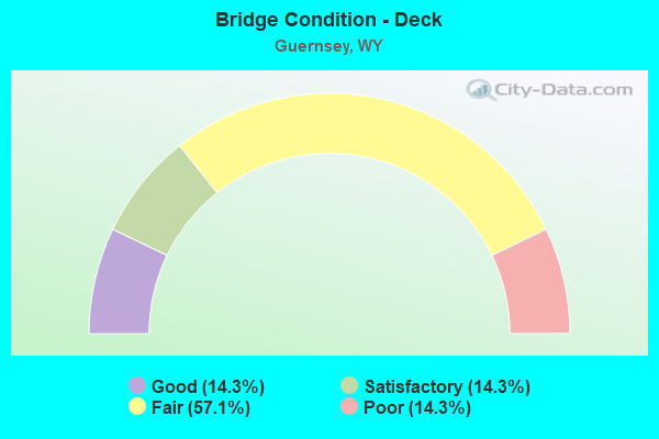
- Bridge Condition - Deck
- 14.3%Good
- 14.3%Satisfactory
- 57.1%Fair
- 14.3%Poor
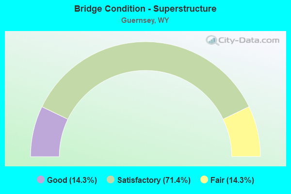
- Bridge Condition - Superstructure
- 14.3%Good
- 71.4%Satisfactory
- 14.3%Fair
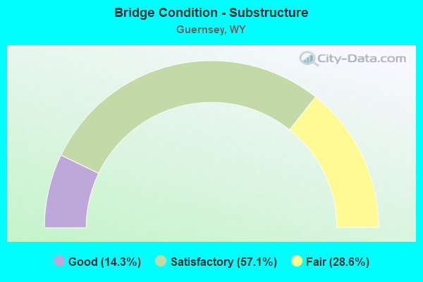
- Bridge Condition - Substructure
- 14.3%Good
- 57.1%Satisfactory
- 28.6%Fair
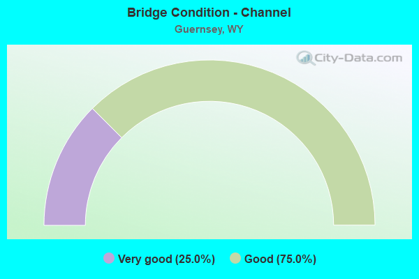
- Bridge Condition - Channel
- 25.0%Very good
- 75.0%Good
Find on map >> Show street view
Structure Number: WYA-NPP-001, Location: 1.8 miles NW of Guernsey (Lat: 42.290825, Lng: -104.764444), Route carried "on" structure: State highway 317, Year Built: 1927, Status: Posted for load, Structure Length: 2.40m (7.87ft), Average Daily Traffic: 100 (year 2011), Average Future Daily Traffic: 110 (year 2041), Features Intersected: Guernsey Dam Spillway, Facility Carried by Structure: Lake Side Drive
Minimum Vertical Clearance: 30+ m (98+ ft), Kilometerpoint: 0.000, Lanes on structure: 1, Owner: Bureau of Reclamation, Approaching Roadway Width: 7.0m (23.0ft), Material/Design: Concrete, Design/Construction: Tee Beam, Number Of Spans In Main Unit: 1, Number Of Approach Spans: 2, Length of Maximum Span: 15.8m (51.8ft), Curb-To-Curb Width: 4.7m (15.4ft), Out-to-Out Width: 6.2m (20.3ft)
Condition: Deck: Fair, Superstructure: Fair, Substructure: Fair, Channel: Good, Operating Rating: 9.0 metric tons, Method Used To Determine Operating Rating: Load Factor (LF), Inventory Rating: 5.4 metric tons, Method Used To Determine Inventory Rating: Load Factor (LF), Structural Evaluation: High priority of corrective action, Deck Geometry: Better than present minimum criteria, Waterway Adequacy: Superior to present desirable criteria, Approach Roadway Alignment: High priority of corrective action, Bridge Posting: Required (Relationship of Operating Rating to Maximum Legal Load: > 39.9% below), Designated Inspection Frequency: Every 24 months, Inspection Date: October 2021, Roadway Improvement Cost: $2,000, Total Project Cost: $2,000 ( Estimate for 2022), Deck Structure Type: Concrete Cast-file-Place
Find on map >> Show street view
Structure Number: BPG, Location: Dwyer Jct - Guernsey (Lat: 42.234597, Lng: -104.944150), Route carried "on" structure: US 26, Year Built: 1966, Status: Open, Structure Length: 9.48m (31.10ft), Average Daily Traffic: 1,893 (year 2021), Truck Traffic: 23%, Average Future Daily Traffic: 2,650 (year 2041), Design Load: HS 20, Features Intersected: BNSF Railway
Minimum Vertical Clearance: 30+ m (98+ ft), Kilometerpoint: 6.540, Lanes on structure: 2, Base Highway Network: Yes, Owner: State Highway Agency, Approaching Roadway Width: 11.6m (38.1ft), Skew: 4 degrees, Material/Design: Steel continuous, Design/Construction: Stringer/Multi-beam, Number Of Spans In Main Unit: 3, Length of Maximum Span: 36.0m (118.1ft), Curb-To-Curb Width: 9.1m (29.9ft), Out-to-Out Width: 10.1m (33.1ft)
Condition: Deck: Fair, Superstructure: Satisfactory, Substructure: Satisfactory, Operating Rating: 52.6 metric tons, Method Used To Determine Operating Rating: Load Factor (LF), Inventory Rating: 30.8 metric tons, Method Used To Determine Inventory Rating: Load Factor (LF), Structural Evaluation: Equal to present minimum criteria, Deck Geometry: Somewhat better than minimum adequacy, Underclear: Equal to present desirable criteria, Approach Roadway Alignment: Equal to present desirable criteria, Length Of Structure Improvement: 9.48m (31.10ft), Designated Inspection Frequency: Every 24 months, Inspection Date: April 2020, Bridge Improvement Cost: $177,000, Roadway Improvement Cost: $18,000, Total Project Cost: $266,000, Deck Structure Type: Concrete Cast-file-Place, Wearing Surface/Protective System: Wearing Surface: Bituminous
Find on map >> Show street view
Structure Number: BXM, Location: Guernsey - Lingle (Lat: 42.264211, Lng: -104.726392), Route carried "on" structure: US 26, Year Built: 1962, Status: Open, Structure Length: 8.78m (28.81ft), Average Daily Traffic: 2,614 (year 2021), Truck Traffic: 13%, Average Future Daily Traffic: 3,660 (year 2041), Design Load: H 20, Features Intersected: BNSF Railway
Minimum Vertical Clearance: 30+ m (98+ ft), Kilometerpoint: 26.030, Lanes on structure: 2, Base Highway Network: Yes, Owner: State Highway Agency, Approaching Roadway Width: 12.2m (40.0ft), Skew: 1 degrees, Material/Design: Steel continuous, Design/Construction: Stringer/Multi-beam, Number Of Spans In Main Unit: 3, Length of Maximum Span: 35.4m (116.1ft), Curb-To-Curb Width: 9.1m (29.9ft), Out-to-Out Width: 10.1m (33.1ft)
Condition: Deck: Poor, Superstructure: Good, Substructure: Good, Operating Rating: 59.0 metric tons, Method Used To Determine Operating Rating: Load Factor (LF), Inventory Rating: 34.5 metric tons, Method Used To Determine Inventory Rating: Load Factor (LF), Structural Evaluation: Better than present minimum criteria, Deck Geometry: Meets minimum limits, Underclear: High priority of corrective action, Approach Roadway Alignment: Equal to present minimum criteria, Designated Inspection Frequency: Every 24 months, Inspection Date: April 2020, Deck Structure Type: Concrete Cast-file-Place, Wearing Surface/Protective System: Wearing Surface: Latex Concrete
Find on map >> Show street view
Structure Number: BXN, Location: Guernsey - Lingle (Lat: 42.257731, Lng: -104.679708), Route carried "on" structure: US 26, Year Built: 1962, Status: Open, Structure Length: 3.44m (11.29ft), Average Daily Traffic: 1,793 (year 2021), Truck Traffic: 18%, Average Future Daily Traffic: 2,510 (year 2041), Design Load: H 20, Features Intersected: Whalen Draw
Minimum Vertical Clearance: 30+ m (98+ ft), Kilometerpoint: 30.048, Lanes on structure: 2, Base Highway Network: Yes, Owner: State Highway Agency, Approaching Roadway Width: 12.2m (40.0ft), Skew: 2 degrees, Material/Design: Steel continuous, Design/Construction: Stringer/Multi-beam, Number Of Spans In Main Unit: 3, Length of Maximum Span: 12.8m (42.0ft), Curb-To-Curb Width: 9.1m (29.9ft), Out-to-Out Width: 10.1m (33.1ft)
Condition: Deck: Fair, Superstructure: Satisfactory, Substructure: Satisfactory, Channel: Very good, Operating Rating: 60.8 metric tons, Method Used To Determine Operating Rating: Load Factor (LF), Inventory Rating: 36.3 metric tons, Method Used To Determine Inventory Rating: Load Factor (LF), Structural Evaluation: Equal to present minimum criteria, Deck Geometry: Somewhat better than minimum adequacy, Waterway Adequacy: Equal to present desirable criteria, Approach Roadway Alignment: Equal to present desirable criteria, Length Of Structure Improvement: 3.44m (11.29ft), Designated Inspection Frequency: Every 24 months, Inspection Date: April 2020, Bridge Improvement Cost: $64,000, Roadway Improvement Cost: $10,000, Total Project Cost: $97,000 ( Estimate for 2014), Deck Structure Type: Concrete Cast-file-Place
Find on map >> Show street view
Structure Number: DQS, Location: T26N R066W S02 (Lat: 42.260356, Lng: -104.741686), Route carried "on" structure: County highway 109S, Year Built: 1964, Status: Open, Structure Length: 6.74m (22.11ft), Average Daily Traffic: 74 (year 2021), Truck Traffic: 10%, Average Future Daily Traffic: 104 (year 2041), Design Load: HS 20, Features Intersected: North Platte River
Minimum Vertical Clearance: 30+ m (98+ ft), Kilometerpoint: 0.328, Lanes on structure: 2, Owner: County Highway Agency, Approaching Roadway Width: 7.9m (25.9ft), Skew: 1 degrees, Material/Design: Steel, Design/Construction: Stringer/Multi-beam, Number Of Spans In Main Unit: 4, Length of Maximum Span: 17.4m (57.1ft), Curb-To-Curb Width: 8.5m (27.9ft), Out-to-Out Width: 9.5m (31.2ft)
Condition: Deck: Fair, Superstructure: Satisfactory, Substructure: Fair, Channel: Good, Operating Rating: 62.6 metric tons, Method Used To Determine Operating Rating: Allowable Stress (AS), Inventory Rating: 37.2 metric tons, Method Used To Determine Inventory Rating: Allowable Stress (AS), Structural Evaluation: Somewhat better than minimum adequacy, Deck Geometry: Better than present minimum criteria, Waterway Adequacy: Equal to present desirable criteria, Approach Roadway Alignment: Equal to present desirable criteria, Length Of Structure Improvement: 11.31m (37.11ft), Designated Inspection Frequency: Every 24 months, Underwater Inspection Frequency: Every 60 months, Inspection Date: November 2021, Underwater Inspection Date: October 2019, Bridge Improvement Cost: $27,000, Roadway Improvement Cost: $30,000, Total Project Cost: $60,000, Deck Structure Type: Concrete Cast-file-Place
Find on map >> Show street view
Structure Number: EOE, Location: Dwyer Jct - Guernsey (Lat: 42.269761, Lng: -104.753072), Route carried "on" structure: US 26, Year Built: 1983, Status: Open, Structure Length: 12.70m (41.67ft), Average Daily Traffic: 2,284 (year 2021), Truck Traffic: 12%, Average Future Daily Traffic: 3,198 (year 2041), Design Load: HS 20, Features Intersected: North Platte River
Minimum Vertical Clearance: 30+ m (98+ ft), Kilometerpoint: 23.630, Lanes on structure: 2, Base Highway Network: Yes, Owner: State Highway Agency, Approaching Roadway Width: 11.6m (38.1ft), Material/Design: Prestressed concrete, Design/Construction: Tee Beam, Number Of Spans In Main Unit: 8, Length of Maximum Span: 15.8m (51.8ft), Curb or Sidewalk Widths: Left: 2.4m (7.9ft), Right: 0.0m, Curb-To-Curb Width: 12.2m (40.0ft), Out-to-Out Width: 15.0m (49.2ft)
Condition: Deck: Satisfactory, Superstructure: Satisfactory, Substructure: Satisfactory, Channel: Good, Operating Rating: 53.5 metric tons, Method Used To Determine Operating Rating: Load Factor (LF), Inventory Rating: 32.0 metric tons, Method Used To Determine Inventory Rating: Load Factor (LF), Structural Evaluation: Equal to present minimum criteria, Deck Geometry: Equal to present minimum criteria, Waterway Adequacy: Equal to present desirable criteria, Approach Roadway Alignment: Equal to present desirable criteria, Designated Inspection Frequency: Every 24 months, Underwater Inspection Frequency: Every 60 months, Inspection Date: April 2020, Underwater Inspection Date: October 2019, Deck Structure Type: Concrete Cast-file-Place, Wearing Surface/Protective System: Wearing Surface: Latex Concrete
Find on map >> Show street view
Structure Number: LAO, Location: Guernsey State Park (Lat: 42.300461, Lng: -104.789631), Route carried "on" structure: State lands road GSP-1, Year Built: 1998, Status: Open, Structure Length: 5.61m (18.41ft), Average Daily Traffic: 55 (year 2021), Truck Traffic: 10%, Average Future Daily Traffic: 77 (year 2041), Design Load: HS 25 or greater, Features Intersected: BNSF Railway, Facility Carried by Structure: Skyline Drive
Minimum Vertical Clearance: 30+ m (98+ ft), Kilometerpoint: 162.310, Lanes on structure: 2, Owner: Railroad, Approaching Roadway Width: 13.4m (44.0ft), Material/Design: Steel, Design/Construction: Stringer/Multi-beam, Number Of Spans In Main Unit: 1, Length of Maximum Span: 54.9m (180.1ft), Curb or Sidewalk Widths: Left: 0.0m, Right: 2.5m (8.2ft), Curb-To-Curb Width: 9.8m (32.2ft), Out-to-Out Width: 13.6m (44.6ft)
Condition: Deck: Good, Superstructure: Satisfactory, Substructure: Satisfactory, Inventory Rating: 91.6 metric tons, Method Used To Determine Inventory Rating: Load Factor (LF), Structural Evaluation: Equal to present minimum criteria, Deck Geometry: Equal to present desirable criteria, Underclear: Superior to present desirable criteria, Approach Roadway Alignment: Better than present minimum criteria, Length Of Structure Improvement: 4.57m (14.99ft), Designated Inspection Frequency: Every 24 months, Inspection Date: November 2020, Bridge Improvement Cost: $2,000, Roadway Improvement Cost: $30,000, Total Project Cost: $33,000, Deck Structure Type: Concrete Cast-file-Place
Find on map >> Show street view
Structure Number: EXM, Location: T27N R066W S35 (Lat: 42.270281, Lng: -104.737531), Route carried "under" structure: County highway 180, Year Built: 1960, Structure Length: 0. m, Average Daily Traffic: 1,236 (year 2021), Truck Traffic: 8%, Features Intersected: Pl County Road 180, Facility Carried by Structure: BNSF Railway
Minimum Vertical Clearance: 0.42m (1.38ft), Kilometerpoint: 0.061, Lanes under structure: 2, Material/Design: Steel continuous, Design/Construction: Stringer/Multi-beam, Length of Maximum Span: 7.3m (24.0ft)
Find on map >> Show street view
Structure Number: FGB, Location: T27N R066 Sec035 (Lat: 42.270436, Lng: -104.737364), Route carried "under" structure: County highway 180, Year Built: 1960, Structure Length: 0. m, Average Daily Traffic: 1,236 (year 2021), Truck Traffic: 8%, Features Intersected: Pleasant Valley Road, Facility Carried by Structure: BNSF Railway
Minimum Vertical Clearance: 0.42m (1.38ft), Kilometerpoint: 0.084, Lanes under structure: 2, Material/Design: Wood or Timber, Design/Construction: Stringer/Multi-beam, Length of Maximum Span: 8.2m (26.9ft)
Find on map >> Show street view
Structure Number: KUH, Location: Guernsey (Lat: 42.270361, Lng: -104.737444), Route carried "under" structure: County highway 180, Year Built: 1960, Structure Length: 0. m, Average Daily Traffic: 1,236 (year 2021), Truck Traffic: 8%, Features Intersected: Pleasant Valley Road, Facility Carried by Structure: BNSF Railway
Minimum Vertical Clearance: 4.32m (14.17ft), Kilometerpoint: 0.072, Lanes under structure: 2, Material/Design: Steel, Design/Construction: Stringer/Multi-beam, Length of Maximum Span: 9.8m (32.2ft)