Bridge Statistics for Guin, Alabama (AL)
Condition, Traffic, Stress, Structural Evaluation, Project Costs
- National Bridge Inventory (NBI) Statistics
- 37Number of bridges
- 331ft / 101mTotal length
- $47,359,000Total costs
- 118,613Total average daily traffic
- 34,836Total average daily truck traffic
- National Bridge Inventory (NBI) Registered Bridges for Guin
- No street view available for this location
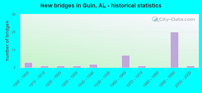
- New bridges - historical statistics
- 31900-1909
- 11910-1919
- 11920-1929
- 11930-1939
- 21940-1949
- 71960-1969
- 11970-1979
- 201990-1999
- 12000-2009

- Reconstructed bridges - Historical Statistics
- 11940-1949
- 11950-1959
- 21960-1969
- 01970-1979
- 01980-1989
- 11990-1999


- Bridge Condition - Deck
- 10.0%Very good
- 50.0%Good
- 20.0%Satisfactory
- 20.0%Fair

- Bridge Condition - Superstructure
- 60.0%Good
- 20.0%Satisfactory
- 20.0%Fair

- Bridge Condition - Substructure
- 40.0%Very good
- 30.0%Good
- 10.0%Satisfactory
- 20.0%Fair

- Bridge Condition - Channel
- 7.4%Very good
- 22.2%Good
- 63.0%Satisfactory
- 7.4%Fair

- Bridge Condition - Culverts
- 23.8%Good
- 61.9%Satisfactory
- 14.3%Fair
Find on map >> Show street view
Structure Number: 366, Location: 0.8 MI E JCT SR 118 (Lat: 33.962000, Lng: -87.930167), Route carried "on" structure: State highway 142, Year Built: 1926, Status: Open, Structure Length: 7.01m (23.00ft), Average Daily Traffic: 380 (year 2020), Truck Traffic: 7%, Average Future Daily Traffic: 450 (year 2041), Design Load: H 15, Features Intersected: BNSF Railroad
Minimum Vertical Clearance: 30+ m (98+ ft), Kilometerpoint: 1.286, Lanes on structure: 2, Owner: State Highway Agency, Approaching Roadway Width: 6.3m (20.7ft), Material/Design: Steel, Design/Construction: Stringer/Multi-beam, Number Of Spans In Main Unit: 1, Number Of Approach Spans: 6, Length of Maximum Span: 17.4m (57.1ft), Curb or Sidewalk Widths: Left: 0.2m (0.7ft), Right: 0.2m (0.7ft), Curb-To-Curb Width: 5.3m (17.4ft), Out-to-Out Width: 6.5m (21.3ft)
Condition: Deck: Fair, Superstructure: Fair, Substructure: Fair, Channel: Satisfactory, Operating Rating: 47.3 metric tons, Method Used To Determine Operating Rating: Load Factor (LF), Inventory Rating: 28.3 metric tons, Method Used To Determine Inventory Rating: Load Factor (LF), Structural Evaluation: Somewhat better than minimum adequacy, Deck Geometry: High priority of replacement, Underclear: Equal to present minimum criteria, Waterway Adequacy: Equal to present desirable criteria, Approach Roadway Alignment: Meets minimum limits, Length Of Structure Improvement: 8.04m (26.38ft), Designated Inspection Frequency: Every 24 months, Inspection Date: Febuary 2022, Bridge Improvement Cost: $1,158,000, Roadway Improvement Cost: $116,000, Total Project Cost: $1,274,000 ( Estimate for 2022), Deck Structure Type: Concrete Cast-file-Place
Find on map >> Show street view
Structure Number: 2051, Location: 0.8 MI W Marion Co Line (Lat: 33.954467, Lng: -87.965633), Route carried "on" structure: US 278, Year Built: 1939, Year Reconstructed: 1996, Status: Open, Structure Length: 0.79m (2.59ft), Average Daily Traffic: 2,320 (year 2020), Truck Traffic: 14%, Average Future Daily Traffic: 3,055 (year 2038), Design Load: H 15, Features Intersected: Branch, Facility Carried by Structure: AL-118
Minimum Vertical Clearance: 30+ m (98+ ft), Kilometerpoint: 26.258, Lanes on structure: 2, Base Highway Network: Yes, Owner: State Highway Agency, Approaching Roadway Width: 9.4m (30.8ft), Material/Design: Concrete, Design/Construction: Culvert, Number Of Spans In Main Unit: 3, Length of Maximum Span: 2.4m (7.9ft)
Condition: Channel: Satisfactory, Culverts: Good, Operating Rating: 82.5 metric tons, Method Used To Determine Operating Rating: Load Factor (LF), Inventory Rating: 49.4 metric tons, Method Used To Determine Inventory Rating: Load Factor (LF), Structural Evaluation: Better than present minimum criteria, Waterway Adequacy: Equal to present minimum criteria, Approach Roadway Alignment: Equal to present desirable criteria, Length Of Structure Improvement: 1.45m (4.76ft), Designated Inspection Frequency: Every 24 months, Inspection Date: November 2020, Bridge Improvement Cost: $368,000, Roadway Improvement Cost: $37,000, Total Project Cost: $405,000 ( Estimate for 2022)
Find on map >> Show street view
Structure Number: 3458, Location: 0.5 MI E JCT SR 253 (Lat: 34.010281, Lng: -87.843778), Route carried "on" structure: State highway 44, Year Built: 1949, Status: Open, Structure Length: 1.83m (6.00ft), Average Daily Traffic: 2,103 (year 2020), Truck Traffic: 10%, Average Future Daily Traffic: 1,974 (year 2033), Design Load: H 15, Features Intersected: Branch
Minimum Vertical Clearance: 7.56m (24.80ft), Kilometerpoint: 8.690, Lanes on structure: 2, Owner: State Highway Agency, Approaching Roadway Width: 6.3m (20.7ft), Skew: 4 degrees, Material/Design: Concrete, Design/Construction: Culvert, Number Of Spans In Main Unit: 4, Length of Maximum Span: 3.0m (9.8ft)
Condition: Channel: Satisfactory, Culverts: Fair, Operating Rating: 55.5 metric tons, Method Used To Determine Operating Rating: Load Factor (LF), Inventory Rating: 33.3 metric tons, Method Used To Determine Inventory Rating: Load Factor (LF), Structural Evaluation: Somewhat better than minimum adequacy, Waterway Adequacy: Better than present minimum criteria, Approach Roadway Alignment: Better than present minimum criteria, Length Of Structure Improvement: 2.54m (8.33ft), Designated Inspection Frequency: Every 24 months, Inspection Date: January 2021, Bridge Improvement Cost: $676,000, Roadway Improvement Cost: $68,000, Total Project Cost: $744,000 ( Estimate for 2022)
Find on map >> Show street view
Structure Number: 3494, Location: 0.2 MI N JCT SR 107 (Lat: 33.962625, Lng: -87.914639), Route carried "on" structure: US 118, Year Built: 1949, Status: Open, Structure Length: 1.31m (4.30ft), Average Daily Traffic: 3,720 (year 2017), Truck Traffic: 14%, Average Future Daily Traffic: 5,120 (year 2033), Design Load: H 15, Features Intersected: Hell Creek
Minimum Vertical Clearance: 30+ m (98+ ft), Kilometerpoint: 31.395, Lanes on structure: 2, Base Highway Network: Yes, Owner: State Highway Agency, Approaching Roadway Width: 7.4m (24.3ft), Material/Design: Concrete, Design/Construction: Culvert, Number Of Spans In Main Unit: 4, Length of Maximum Span: 3.0m (9.8ft)
Condition: Channel: Satisfactory, Culverts: Good, Operating Rating: 47.2 metric tons, Method Used To Determine Operating Rating: Load Factor (LF), Inventory Rating: 28.1 metric tons, Method Used To Determine Inventory Rating: Load Factor (LF), Structural Evaluation: Better than present minimum criteria, Waterway Adequacy: Better than present minimum criteria, Approach Roadway Alignment: Better than present minimum criteria, Length Of Structure Improvement: 1.98m (6.50ft), Designated Inspection Frequency: Every 24 months, Inspection Date: November 2020, Bridge Improvement Cost: $573,000, Roadway Improvement Cost: $57,000, Total Project Cost: $630,000 ( Estimate for 2022)
Find on map >> Show street view
Structure Number: 4494, Location: 5 MILES NORTH OF GUIN (Lat: 34.032500, Lng: -87.905694), Route carried "on" structure: County highway 45, Year Built: 1900, Year Reconstructed: 1953, Status: Open, Structure Length: 0.79m (2.59ft), Average Daily Traffic: 230 (year 2001), Truck Traffic: 15%, Average Future Daily Traffic: 450 (year 2035), Design Load: H 15, Features Intersected: Flurry Branch
Minimum Vertical Clearance: 30+ m (98+ ft), Kilometerpoint: 0.010, Lanes on structure: 2, Owner: County Highway Agency, Approaching Roadway Width: 7.3m (24.0ft), Material/Design: Concrete, Design/Construction: Culvert, Number Of Spans In Main Unit: 3, Length of Maximum Span: 2.4m (7.9ft)
Condition: Channel: Satisfactory, Culverts: Satisfactory, Operating Rating: 39.8 metric tons, Method Used To Determine Operating Rating: Load Factor (LF), Inventory Rating: 23.9 metric tons, Method Used To Determine Inventory Rating: Load Factor (LF), Structural Evaluation: Equal to present minimum criteria, Waterway Adequacy: Better than present minimum criteria, Approach Roadway Alignment: Better than present minimum criteria, Length Of Structure Improvement: 1.44m (4.72ft), Designated Inspection Frequency: Every 24 months, Inspection Date: Febuary 2021, Bridge Improvement Cost: $217,000, Roadway Improvement Cost: $22,000, Total Project Cost: $239,000 ( Estimate for 2022)
Find on map >> Show street view
Structure Number: 6429, Location: 2 MILES WEST OF GUIN (Lat: 33.967278, Lng: -87.937056), Route carried "on" structure: County highway 16, Year Built: 1900, Year Reconstructed: 1959, Status: Open, Structure Length: 2.41m (7.91ft), Average Daily Traffic: 340 (year 2001), Truck Traffic: 50%, Average Future Daily Traffic: 686 (year 2035), Design Load: H 20, Features Intersected: Beaver Creek Relief
Minimum Vertical Clearance: 30+ m (98+ ft), Kilometerpoint: 0.010, Lanes on structure: 2, Owner: County Highway Agency, Approaching Roadway Width: 7.3m (24.0ft), Material/Design: Concrete, Design/Construction: Culvert, Number Of Spans In Main Unit: 5, Length of Maximum Span: 4.6m (15.1ft)
Condition: Channel: Satisfactory, Culverts: Satisfactory, Operating Rating: 42.1 metric tons, Method Used To Determine Operating Rating: Load Factor (LF), Inventory Rating: 25.2 metric tons, Method Used To Determine Inventory Rating: Load Factor (LF), Structural Evaluation: Equal to present minimum criteria, Waterway Adequacy: Better than present minimum criteria, Approach Roadway Alignment: Equal to present desirable criteria, Length Of Structure Improvement: 3.27m (10.73ft), Designated Inspection Frequency: Every 24 months, Inspection Date: Febuary 2021, Bridge Improvement Cost: $529,000, Roadway Improvement Cost: $53,000, Total Project Cost: $582,000 ( Estimate for 2022)
Find on map >> Show street view
Structure Number: 7771, Location: 5 MILES NE OF GUIN (Lat: 34.002417, Lng: -87.852056), Route carried "on" structure: County highway 83, Year Built: 1962, Status: Open, Structure Length: 1.31m (4.30ft), Average Daily Traffic: 80 (year 2001), Average Future Daily Traffic: 157 (year 2035), Design Load: H 15, Features Intersected: Luxapallila Creek
Minimum Vertical Clearance: 30+ m (98+ ft), Kilometerpoint: 0.010, Lanes on structure: 2, Owner: County Highway Agency, Approaching Roadway Width: 7.3m (24.0ft), Material/Design: Concrete, Design/Construction: Culvert, Number Of Spans In Main Unit: 4, Length of Maximum Span: 3.0m (9.8ft)
Condition: Channel: Satisfactory, Culverts: Satisfactory, Operating Rating: 43.7 metric tons, Method Used To Determine Operating Rating: Load Factor (LF), Inventory Rating: 26.2 metric tons, Method Used To Determine Inventory Rating: Load Factor (LF), Structural Evaluation: Equal to present minimum criteria, Waterway Adequacy: Better than present minimum criteria, Approach Roadway Alignment: Better than present minimum criteria, Length Of Structure Improvement: 1.98m (6.50ft), Designated Inspection Frequency: Every 24 months, Inspection Date: Febuary 2021, Bridge Improvement Cost: $298,000, Roadway Improvement Cost: $30,000, Total Project Cost: $328,000 ( Estimate for 2022)
Find on map >> Show street view
Structure Number: 7886, Location: 2.7 MI. N. CO. RD. 36 (Lat: 33.883056, Lng: -87.955556), Route carried "on" structure: County highway 61, Year Built: 1963, Status: Open, Structure Length: 0.98m (3.22ft), Average Daily Traffic: 60 (year 2016), Truck Traffic: 4%, Average Future Daily Traffic: 89 (year 2036), Design Load: H 15, Features Intersected: YELLOW CREEK, Facility Carried by Structure: MT GAP RD
Minimum Vertical Clearance: 30+ m (98+ ft), Kilometerpoint: 0.010, Lanes on structure: 2, Owner: County Highway Agency, Approaching Roadway Width: 7.3m (24.0ft), Material/Design: Concrete, Design/Construction: Culvert, Number Of Spans In Main Unit: 3, Length of Maximum Span: 3.0m (9.8ft)
Condition: Channel: Satisfactory, Culverts: Satisfactory, Operating Rating: 88.9 metric tons, Method Used To Determine Operating Rating: Load Factor (LF), Inventory Rating: 53.3 metric tons, Method Used To Determine Inventory Rating: Load Factor (LF), Structural Evaluation: Equal to present minimum criteria, Waterway Adequacy: Better than present minimum criteria, Approach Roadway Alignment: Equal to present minimum criteria, Length Of Structure Improvement: 1.65m (5.41ft), Designated Inspection Frequency: Every 24 months, Inspection Date: November 2020, Bridge Improvement Cost: $325,000, Roadway Improvement Cost: $33,000, Total Project Cost: $358,000 ( Estimate for 2022), Wearing Surface/Protective System: Wearing Surface: Bituminous
Find on map >> Show street view
Structure Number: 7889, Location: 2.8 MI N CO RD 36 (Lat: 33.883100, Lng: -87.955600), Route carried "on" structure: County highway 61, Year Built: 1963, Status: Open, Structure Length: 0.98m (3.22ft), Average Daily Traffic: 60 (year 2016), Truck Traffic: 4%, Average Future Daily Traffic: 89 (year 2036), Design Load: HS 20, Features Intersected: YELLOW CREEK RELIEF, Facility Carried by Structure: MT GAP RD
Minimum Vertical Clearance: 30+ m (98+ ft), Kilometerpoint: 0.000, Lanes on structure: 2, Owner: County Highway Agency, Approaching Roadway Width: 7.3m (24.0ft), Material/Design: Concrete, Design/Construction: Culvert, Number Of Spans In Main Unit: 3, Length of Maximum Span: 3.4m (11.2ft)
Condition: Channel: Good, Culverts: Satisfactory, Operating Rating: 51.3 metric tons, Method Used To Determine Operating Rating: Load Factor (LF), Inventory Rating: 30.8 metric tons, Method Used To Determine Inventory Rating: Load Factor (LF), Structural Evaluation: Equal to present minimum criteria, Waterway Adequacy: Somewhat better than minimum adequacy, Approach Roadway Alignment: Equal to present minimum criteria, Length Of Structure Improvement: 1.65m (5.41ft), Designated Inspection Frequency: Every 24 months, Inspection Date: November 2020, Bridge Improvement Cost: $334,000, Roadway Improvement Cost: $33,000, Total Project Cost: $367,000 ( Estimate for 2022), Wearing Surface/Protective System: Wearing Surface: Bituminous
Find on map >> Show street view
Structure Number: 8068, Location: 0.3 MI W JCT SR 107 (Lat: 33.954750, Lng: -87.936083), Route carried "on" structure: US 118, Year Built: 1963, Status: Open, Structure Length: 1.65m (5.41ft), Average Daily Traffic: 2,250 (year 2017), Truck Traffic: 18%, Average Future Daily Traffic: 3,097 (year 2033), Design Load: HS 20, Features Intersected: Branch
Minimum Vertical Clearance: 30+ m (98+ ft), Kilometerpoint: 29.290, Lanes on structure: 2, Base Highway Network: Yes, Owner: State Highway Agency, Approaching Roadway Width: 7.4m (24.3ft), Skew: 4 degrees, Material/Design: Concrete, Design/Construction: Culvert, Number Of Spans In Main Unit: 3, Length of Maximum Span: 3.7m (12.1ft)
Condition: Channel: Fair, Culverts: Fair, Operating Rating: 70.8 metric tons, Method Used To Determine Operating Rating: Load Factor (LF), Inventory Rating: 42.6 metric tons, Method Used To Determine Inventory Rating: Load Factor (LF), Structural Evaluation: Somewhat better than minimum adequacy, Waterway Adequacy: Better than present minimum criteria, Approach Roadway Alignment: Better than present minimum criteria, Length Of Structure Improvement: 2.34m (7.68ft), Designated Inspection Frequency: Every 24 months, Inspection Date: November 2020, Bridge Improvement Cost: $946,000, Roadway Improvement Cost: $95,000, Total Project Cost: $1,041,000 ( Estimate for 2022)
Find on map >> Show street view
Structure Number: 8489, Location: 2 MILES NW OF GUIN (Lat: 33.991167, Lng: -87.930833), Route carried "on" structure: County highway 45, Year Built: 1900, Year Reconstructed: 1965, Status: Open, Structure Length: 1.95m (6.40ft), Average Daily Traffic: 305 (year 2001), Truck Traffic: 25%, Average Future Daily Traffic: 598 (year 2035), Design Load: H 15, Features Intersected: Beaver Creek, Facility Carried by Structure: Frye Road
Minimum Vertical Clearance: 30+ m (98+ ft), Kilometerpoint: 0.010, Lanes on structure: 2, Owner: County Highway Agency, Approaching Roadway Width: 7.3m (24.0ft), Material/Design: Concrete, Design/Construction: Culvert, Number Of Spans In Main Unit: 5, Length of Maximum Span: 3.7m (12.1ft)
Condition: Channel: Satisfactory, Culverts: Fair, Operating Rating: 33.0 metric tons, Method Used To Determine Operating Rating: Load Factor (LF), Inventory Rating: 19.8 metric tons, Method Used To Determine Inventory Rating: Load Factor (LF), Structural Evaluation: Somewhat better than minimum adequacy, Waterway Adequacy: Better than present minimum criteria, Approach Roadway Alignment: Better than present minimum criteria, Length Of Structure Improvement: 2.69m (8.83ft), Designated Inspection Frequency: Every 24 months, Inspection Date: Febuary 2021, Bridge Improvement Cost: $420,000, Roadway Improvement Cost: $42,000, Total Project Cost: $462,000 ( Estimate for 2022)
Find on map >> Show street view
Structure Number: 8494, Location: 2 MILES NW OF GUIN (Lat: 33.991583, Lng: -87.932194), Route carried "on" structure: County highway 45, Year Built: 1919, Year Reconstructed: 1965, Status: Open, Structure Length: 0.79m (2.59ft), Average Daily Traffic: 305 (year 2001), Truck Traffic: 25%, Average Future Daily Traffic: 686 (year 2035), Design Load: H 15, Features Intersected: Beaver Creek Relief, Facility Carried by Structure: Frye Road
Minimum Vertical Clearance: 30+ m (98+ ft), Kilometerpoint: 0.010, Lanes on structure: 2, Owner: County Highway Agency, Approaching Roadway Width: 7.3m (24.0ft), Material/Design: Concrete, Design/Construction: Culvert, Number Of Spans In Main Unit: 3, Length of Maximum Span: 2.4m (7.9ft)
Condition: Channel: Satisfactory, Culverts: Satisfactory, Operating Rating: 33.8 metric tons, Method Used To Determine Operating Rating: Load Factor (LF), Inventory Rating: 20.3 metric tons, Method Used To Determine Inventory Rating: Load Factor (LF), Structural Evaluation: Somewhat better than minimum adequacy, Waterway Adequacy: Better than present minimum criteria, Approach Roadway Alignment: Better than present minimum criteria, Length Of Structure Improvement: 1.44m (4.72ft), Designated Inspection Frequency: Every 24 months, Inspection Date: Febuary 2021, Bridge Improvement Cost: $183,000, Roadway Improvement Cost: $18,000, Total Project Cost: $201,000 ( Estimate for 2022)
Find on map >> Show street view
Structure Number: 8691, Location: 3.5 MI NW OF WAYSIDE (Lat: 33.904756, Lng: -87.944869), Route carried "on" structure: County highway 40000, Year Built: 1965, Status: Posted for load, Structure Length: 1.28m (4.20ft), Average Daily Traffic: 45 (year 1996), Average Future Daily Traffic: 60 (year 2034), Features Intersected: KIRK BRANCH, Facility Carried by Structure: REED RD.
Minimum Vertical Clearance: 30+ m (98+ ft), Kilometerpoint: 0.010, Lanes on structure: 1, Owner: County Highway Agency, Approaching Roadway Width: 5.5m (18.0ft), Material/Design: Steel, Design/Construction: Stringer/Multi-beam, Number Of Spans In Main Unit: 1, Length of Maximum Span: 12.8m (42.0ft), Curb-To-Curb Width: 4.3m (14.1ft), Out-to-Out Width: 4.3m (14.1ft)
Condition: Deck: Good, Superstructure: Satisfactory, Substructure: Satisfactory, Channel: Good, Operating Rating: 7.3 metric tons, Method Used To Determine Operating Rating: Allowable Stress (AS), Inventory Rating: 5.6 metric tons, Method Used To Determine Inventory Rating: Allowable Stress (AS), Structural Evaluation: High priority of replacement, Deck Geometry: Equal to present minimum criteria, Waterway Adequacy: Better than present minimum criteria, Approach Roadway Alignment: Equal to present minimum criteria, Bridge Posting: Required (Relationship of Operating Rating to Maximum Legal Load: > 39.9% below), Length Of Structure Improvement: 1.95m (6.40ft), Designated Inspection Frequency: Every 24 months, Other Special Inspection Frequency: Every 12 months, Inspection Date: May 2021, Other Special Inspection Date: May 2021, Bridge Improvement Cost: $174,000, Roadway Improvement Cost: $17,000, Total Project Cost: $191,000 ( Estimate for 2022), Deck Structure Type: Wood or Timber, Wearing Surface/Protective System: Wearing Surface: Wood or Timber
Find on map >> Show street view
Structure Number: 8871, Location: 1 MI E JCT AL-44 (Lat: 33.966611, Lng: -87.892778), Route carried "on" structure: US 118, Year Built: 1965, Status: Open, Structure Length: 1.31m (4.30ft), Average Daily Traffic: 5,686 (year 2020), Truck Traffic: 8%, Average Future Daily Traffic: 10,446 (year 2033), Design Load: H 20, Features Intersected: Purgatory Creek
Minimum Vertical Clearance: 30+ m (98+ ft), Kilometerpoint: 33.708, Lanes on structure: 4, Base Highway Network: Yes, Owner: State Highway Agency, Approaching Roadway Width: 20.0m (65.6ft), Material/Design: Concrete, Design/Construction: Culvert, Number Of Spans In Main Unit: 4, Length of Maximum Span: 3.0m (9.8ft)
Condition: Channel: Satisfactory, Culverts: Satisfactory, Operating Rating: 42.6 metric tons, Method Used To Determine Operating Rating: Load Factor (LF), Inventory Rating: 25.4 metric tons, Method Used To Determine Inventory Rating: Load Factor (LF), Structural Evaluation: Equal to present minimum criteria, Waterway Adequacy: Better than present minimum criteria, Approach Roadway Alignment: Equal to present desirable criteria, Length Of Structure Improvement: 1.98m (6.50ft), Designated Inspection Frequency: Every 24 months, Inspection Date: November 2020, Bridge Improvement Cost: $1,031,000, Roadway Improvement Cost: $103,000, Total Project Cost: $1,134,000 ( Estimate for 2022)
Find on map >> Show street view
Structure Number: 9299, Location: .5 MI N US 278 (Lat: 33.962250, Lng: -87.920278), Route carried "on" structure: County highway , Year Built: 1967, Status: Open, Structure Length: 1.34m (4.40ft), Average Daily Traffic: 200 (year 2001), Truck Traffic: 20%, Average Future Daily Traffic: 392 (year 2035), Design Load: H 15, Features Intersected: Purgatory Creek, Facility Carried by Structure: Sawmill Road
Minimum Vertical Clearance: 30+ m (98+ ft), Kilometerpoint: 0.010, Lanes on structure: 2, Owner: County Highway Agency, Approaching Roadway Width: 8.5m (27.9ft), Skew: 3 degrees, Material/Design: Concrete, Design/Construction: Culvert, Number Of Spans In Main Unit: 3, Length of Maximum Span: 3.7m (12.1ft)
Condition: Channel: Satisfactory, Culverts: Satisfactory, Operating Rating: 54.0 metric tons, Method Used To Determine Operating Rating: Load Factor (LF), Inventory Rating: 32.4 metric tons, Method Used To Determine Inventory Rating: Load Factor (LF), Structural Evaluation: Equal to present minimum criteria, Waterway Adequacy: Better than present minimum criteria, Approach Roadway Alignment: Equal to present desirable criteria, Length Of Structure Improvement: 2.02m (6.63ft), Designated Inspection Frequency: Every 24 months, Inspection Date: Febuary 2021, Bridge Improvement Cost: $512,000, Roadway Improvement Cost: $51,000, Total Project Cost: $563,000 ( Estimate for 2022)
Find on map >> Show street view
Structure Number: 10828, Location: 0.3 MILES SOUTH JCT 45 (Lat: 34.021933, Lng: -87.908042), Route carried "on" structure: County highway , Year Built: 1973, Status: Posted for load, Structure Length: 1.95m (6.40ft), Average Daily Traffic: 50 (year 2001), Average Future Daily Traffic: 79 (year 2035), Features Intersected: BEAVER CREEK, Facility Carried by Structure: PAVED ROAD
Minimum Vertical Clearance: 30+ m (98+ ft), Kilometerpoint: 0.010, Lanes on structure: 1, Owner: County Highway Agency, Approaching Roadway Width: 4.9m (16.1ft), Material/Design: Wood or Timber, Design/Construction: Stringer/Multi-beam, Number Of Spans In Main Unit: 1, Length of Maximum Span: 19.5m (64.0ft), Curb-To-Curb Width: 3.6m (11.8ft), Out-to-Out Width: 4.1m (13.5ft)
Condition: Deck: Fair, Superstructure: Fair, Substructure: Fair, Channel: Satisfactory, Operating Rating: 18.1 metric tons, Method Used To Determine Operating Rating: Allowable Stress (AS), Inventory Rating: 10.0 metric tons, Method Used To Determine Inventory Rating: Allowable Stress (AS), Structural Evaluation: High priority of replacement, Deck Geometry: High priority of corrective action, Waterway Adequacy: Better than present minimum criteria, Approach Roadway Alignment: Equal to present minimum criteria, Bridge Posting: Required (Relationship of Operating Rating to Maximum Legal Load: > 39.9% below), Length Of Structure Improvement: 2.69m (8.83ft), Designated Inspection Frequency: Every 24 months, Other Special Inspection Frequency: Every 12 months, Inspection Date: October 2020, Other Special Inspection Date: October 2021, Bridge Improvement Cost: $240,000, Roadway Improvement Cost: $24,000, Total Project Cost: $264,000 ( Estimate for 2022), Deck Structure Type: Concrete Cast-file-Place
Find on map >> Show street view
Structure Number: 15364, Location: 0.2 MILES SOUTH OF CO 45 (Lat: 34.032583, Lng: -87.899583), Route carried "on" structure: County highway , Year Built: 1991, Status: Open, Structure Length: 1.13m (3.71ft), Average Daily Traffic: 30 (year 2001), Average Future Daily Traffic: 59 (year 2035), Design Load: HS 20, Features Intersected: Beaver Creek, Facility Carried by Structure: County Road 463
Minimum Vertical Clearance: 30+ m (98+ ft), Kilometerpoint: 0.010, Lanes on structure: 2, Owner: County Highway Agency, Approaching Roadway Width: 7.3m (24.0ft), Skew: 2 degrees, Material/Design: Concrete, Design/Construction: Culvert, Number Of Spans In Main Unit: 3, Length of Maximum Span: 3.7m (12.1ft)
Condition: Channel: Satisfactory, Culverts: Satisfactory, Operating Rating: 53.1 metric tons, Method Used To Determine Operating Rating: Load Factor (LF), Inventory Rating: 31.8 metric tons, Method Used To Determine Inventory Rating: Load Factor (LF), Structural Evaluation: Equal to present minimum criteria, Waterway Adequacy: Better than present minimum criteria, Approach Roadway Alignment: Equal to present minimum criteria, Length Of Structure Improvement: 1.81m (5.94ft), Designated Inspection Frequency: Every 24 months, Inspection Date: Febuary 2021, Bridge Improvement Cost: $292,000, Roadway Improvement Cost: $29,000, Total Project Cost: $321,000 ( Estimate for 2022)
Find on map >> Show street view
Structure Number: 15718, Location: 3.9MI E US-43 (Lat: 34.046614, Lng: -87.916464), Route carried "on" structure: County highway 4, Year Built: 1991, Status: Open, Structure Length: 9.36m (30.71ft), Average Daily Traffic: 100 (year 2020), Truck Traffic: 8%, Average Future Daily Traffic: 200 (year 2040), Design Load: HS 20, Features Intersected: I-22, Facility Carried by Structure: CR- 37
Minimum Vertical Clearance: 30+ m (98+ ft), Kilometerpoint: 20.730, Lanes on structure: 2, Lanes under structure: 4, Owner: State Highway Agency, Approaching Roadway Width: 6.5m (21.3ft), Skew: 2 degrees, Material/Design: Prestressed concrete, Design/Construction: Stringer/Multi-beam, Number Of Spans In Main Unit: 4, Length of Maximum Span: 29.3m (96.1ft), Curb-To-Curb Width: 8.5m (27.9ft), Out-to-Out Width: 9.4m (30.8ft)
Condition: Deck: Good, Superstructure: Good, Substructure: Good, Operating Rating: 44.1 metric tons, Method Used To Determine Operating Rating: Load Factor (LF), Inventory Rating: 31.9 metric tons, Method Used To Determine Inventory Rating: Load Factor (LF), Structural Evaluation: Better than present minimum criteria, Deck Geometry: Better than present minimum criteria, Underclear: Superior to present desirable criteria, Approach Roadway Alignment: Better than present minimum criteria, Length Of Structure Improvement: 10.32m (33.86ft), Designated Inspection Frequency: Every 24 months, Inspection Date: July 2020, Bridge Improvement Cost: $2,122,000, Roadway Improvement Cost: $212,000, Total Project Cost: $2,334,000 ( Estimate for 2022), Deck Structure Type: Concrete Cast-file-Place
Find on map >> Show street view
Structure Number: 15725, Location: 4.9 MI E US-43 (Lat: 34.043986, Lng: -87.897181), Route carried "on" structure: County highway 4, Year Built: 1992, Status: Open, Structure Length: 9.20m (30.18ft), Average Daily Traffic: 100 (year 2020), Truck Traffic: 8%, Average Future Daily Traffic: 200 (year 2040), Design Load: HS 20, Features Intersected: I-22
Minimum Vertical Clearance: 30+ m (98+ ft), Kilometerpoint: 21.699, Lanes on structure: 2, Lanes under structure: 4, Owner: State Highway Agency, Approaching Roadway Width: 5.9m (19.4ft), Material/Design: Prestressed concrete, Design/Construction: Stringer/Multi-beam, Number Of Spans In Main Unit: 4, Length of Maximum Span: 26.8m (87.9ft), Curb-To-Curb Width: 8.7m (28.5ft), Out-to-Out Width: 9.4m (30.8ft)
Condition: Deck: Very good, Superstructure: Good, Substructure: Very good, Operating Rating: 47.0 metric tons, Method Used To Determine Operating Rating: Load Factor (LF), Inventory Rating: 33.6 metric tons, Method Used To Determine Inventory Rating: Load Factor (LF), Structural Evaluation: Better than present minimum criteria, Deck Geometry: Better than present minimum criteria, Underclear: Equal to present desirable criteria, Approach Roadway Alignment: Equal to present desirable criteria, Length Of Structure Improvement: 10.16m (33.33ft), Designated Inspection Frequency: Every 24 months, Inspection Date: July 2020, Bridge Improvement Cost: $2,090,000, Roadway Improvement Cost: $209,000, Total Project Cost: $2,299,000 ( Estimate for 2022), Deck Structure Type: Concrete Cast-file-Place
Find on map >> Show street view
Structure Number: 1606, Location: 1.1 MI W CO RD 45 (Lat: 34.045806, Lng: -87.907889), Route carried "on" structure: Interstate 22, Year Built: 1992, Status: Open, Structure Length: 0.67m (2.20ft), Average Daily Traffic: 10,830 (year 2016), Truck Traffic: 34%, Average Future Daily Traffic: 13,711 (year 2038), Design Load: HS 20, Features Intersected: Flurry Branch
Minimum Vertical Clearance: 30+ m (98+ ft), Kilometerpoint: 34.440, Lanes on structure: 4, Base Highway Network: Yes, Owner: State Highway Agency, Approaching Roadway Width: 24.0m (78.7ft), Skew: 21 degrees, Material/Design: Concrete, Design/Construction: Culvert, Number Of Spans In Main Unit: 2, Length of Maximum Span: 2.7m (8.9ft)
Condition: Channel: Fair, Culverts: Satisfactory, Operating Rating: 88.9 metric tons, Method Used To Determine Operating Rating: Load Factor (LF), Inventory Rating: 88.9 metric tons, Method Used To Determine Inventory Rating: Load Factor (LF), Structural Evaluation: Equal to present minimum criteria, Waterway Adequacy: Better than present minimum criteria, Approach Roadway Alignment: Equal to present desirable criteria, Length Of Structure Improvement: 1.30m (4.27ft), Designated Inspection Frequency: Every 24 months, Inspection Date: May 2020, Bridge Improvement Cost: $3,686,000, Roadway Improvement Cost: $369,000, Total Project Cost: $4,055,000 ( Estimate for 2022)
Find on map >> Show street view
Structure Number: 16069, Location: 5.6 MI East of US-43 (Lat: 34.041244, Lng: -87.888814), Route carried "on" structure: Interstate 22, Year Built: 1991, Status: Open, Structure Length: 13.66m (44.82ft), Average Daily Traffic: 5,060 (year 2018), Truck Traffic: 34%, Average Future Daily Traffic: 6,855 (year 2040), Design Load: HS 20, Features Intersected: CR-45
Minimum Vertical Clearance: 30+ m (98+ ft), Kilometerpoint: 36.210, Lanes on structure: 2, Lanes under structure: 2, Base Highway Network: Yes, Owner: State Highway Agency, Approaching Roadway Width: 11.3m (37.1ft), Skew: 14 degrees, Material/Design: Prestressed concrete, Design/Construction: Stringer/Multi-beam, Number Of Spans In Main Unit: 5, Length of Maximum Span: 35.1m (115.2ft), Curb-To-Curb Width: 12.3m (40.4ft), Out-to-Out Width: 12.9m (42.3ft)
Condition: Deck: Satisfactory, Superstructure: Satisfactory, Substructure: Good, Channel: Very good, Operating Rating: 59.2 metric tons, Method Used To Determine Operating Rating: Load Factor (LF), Inventory Rating: 33.2 metric tons, Method Used To Determine Inventory Rating: Load Factor (LF), Structural Evaluation: Equal to present minimum criteria, Deck Geometry: Better than present minimum criteria, Underclear: Superior to present desirable criteria, Waterway Adequacy: Equal to present desirable criteria, Approach Roadway Alignment: Equal to present desirable criteria, Length Of Structure Improvement: 14.46m (47.44ft), Designated Inspection Frequency: Every 24 months, Inspection Date: July 2020, Bridge Improvement Cost: $4,164,000, Roadway Improvement Cost: $416,000, Total Project Cost: $4,580,000 ( Estimate for 2022), Deck Structure Type: Concrete Cast-file-Place
Find on map >> Show street view
Structure Number: 1607, Location: 5.6 Miles E of US-43 (Lat: 34.041400, Lng: -87.888500), Route carried "on" structure: Ramp Interstate 4, Year Built: 1991, Status: Open, Structure Length: 1.10m (3.61ft), Average Daily Traffic: 1,012 (year 2016), Truck Traffic: 34%, Average Future Daily Traffic: 1,371 (year 2038), Design Load: HS 20, Features Intersected: Off-Ramp WB Lanes, Facility Carried by Structure: I-22
Minimum Vertical Clearance: 30+ m (98+ ft), Kilometerpoint: 36.210, Lanes on structure: 1, Base Highway Network: Yes, Owner: State Highway Agency, Approaching Roadway Width: 7.5m (24.6ft), Skew: 2 degrees, Material/Design: Concrete, Design/Construction: Culvert, Number Of Spans In Main Unit: 3, Length of Maximum Span: 3.7m (12.1ft)
Condition: Channel: Good, Culverts: Good, Operating Rating: 64.1 metric tons, Method Used To Determine Operating Rating: Load Factor (LF), Inventory Rating: 38.5 metric tons, Method Used To Determine Inventory Rating: Load Factor (LF), Structural Evaluation: Better than present minimum criteria, Waterway Adequacy: Equal to present desirable criteria, Approach Roadway Alignment: Equal to present desirable criteria, Length Of Structure Improvement: 1.77m (5.81ft), Designated Inspection Frequency: Every 24 months, Inspection Date: May 2020, Bridge Improvement Cost: $1,666,000, Roadway Improvement Cost: $167,000, Total Project Cost: $1,833,000 ( Estimate for 2022)
Find on map >> Show street view
Structure Number: 16071, Location: 5.6 Miles E of US-43 (Lat: 34.040250, Lng: -87.888917), Route carried "on" structure: Ramp Interstate 22, Year Built: 1991, Status: Open, Structure Length: 1.10m (3.61ft), Average Daily Traffic: 1,012 (year 2016), Truck Traffic: 34%, Average Future Daily Traffic: 1,371 (year 2040), Design Load: HS 20, Features Intersected: On-Ramp EB Lanes
Minimum Vertical Clearance: 30+ m (98+ ft), Kilometerpoint: 36.210, Lanes on structure: 1, Base Highway Network: Yes, Owner: State Highway Agency, Approaching Roadway Width: 7.5m (24.6ft), Skew: 3 degrees, Material/Design: Concrete, Design/Construction: Culvert, Number Of Spans In Main Unit: 3, Length of Maximum Span: 3.7m (12.1ft)
Condition: Channel: Good, Culverts: Satisfactory, Operating Rating: 88.9 metric tons, Method Used To Determine Operating Rating: Load Factor (LF), Inventory Rating: 59.8 metric tons, Method Used To Determine Inventory Rating: Load Factor (LF), Structural Evaluation: Equal to present minimum criteria, Waterway Adequacy: Equal to present desirable criteria, Approach Roadway Alignment: Equal to present desirable criteria, Length Of Structure Improvement: 1.77m (5.81ft), Designated Inspection Frequency: Every 24 months, Inspection Date: May 2020, Bridge Improvement Cost: $3,331,000, Roadway Improvement Cost: $333,000, Total Project Cost: $3,664,000 ( Estimate for 2022)
Find on map >> Show street view
Structure Number: 16074, Location: 2.3 MI W AL-44 (Lat: 34.030917, Lng: -87.868083), Route carried "on" structure: County highway 4, Year Built: 1994, Status: Open, Structure Length: 12.25m (40.19ft), Average Daily Traffic: 75 (year 2018), Truck Traffic: 2%, Average Future Daily Traffic: 175 (year 2040), Design Load: HS 20, Features Intersected: I-22, Facility Carried by Structure: CR-50
Minimum Vertical Clearance: 30+ m (98+ ft), Kilometerpoint: 23.699, Lanes on structure: 2, Lanes under structure: 4, Owner: State Highway Agency, Approaching Roadway Width: 6.1m (20.0ft), Skew: 2 degrees, Material/Design: Prestressed concrete, Design/Construction: Stringer/Multi-beam, Number Of Spans In Main Unit: 4, Length of Maximum Span: 36.0m (118.1ft), Curb-To-Curb Width: 8.6m (28.2ft), Out-to-Out Width: 9.4m (30.8ft)
Condition: Deck: Good, Superstructure: Good, Substructure: Very good, Operating Rating: 76.5 metric tons, Method Used To Determine Operating Rating: Load Factor (LF), Inventory Rating: 47.2 metric tons, Method Used To Determine Inventory Rating: Load Factor (LF), Structural Evaluation: Better than present minimum criteria, Deck Geometry: Better than present minimum criteria, Underclear: Superior to present desirable criteria, Approach Roadway Alignment: Somewhat better than minimum adequacy, Length Of Structure Improvement: 13.10m (42.98ft), Designated Inspection Frequency: Every 24 months, Inspection Date: July 2020, Bridge Improvement Cost: $2,694,000, Roadway Improvement Cost: $269,000, Total Project Cost: $2,963,000 ( Estimate for 2022), Deck Structure Type: Concrete Cast-file-Place
Find on map >> Show street view
Structure Number: 16075, Location: 7.4 Miles E of US-43 (Lat: 34.027361, Lng: -87.858361), Route carried "on" structure: Interstate 22, Year Built: 1991, Status: Open, Structure Length: 0.61m (2.00ft), Average Daily Traffic: 10,830 (year 2016), Truck Traffic: 32%, Average Future Daily Traffic: 14,117 (year 2040), Design Load: HS 20, Features Intersected: Cooper Creek
Minimum Vertical Clearance: 30+ m (98+ ft), Kilometerpoint: 39.107, Lanes on structure: 4, Base Highway Network: Yes, Owner: State Highway Agency, Approaching Roadway Width: 21.9m (71.9ft), Skew: 10 degrees, Material/Design: Concrete, Design/Construction: Culvert, Number Of Spans In Main Unit: 2, Length of Maximum Span: 3.0m (9.8ft)
Condition: Channel: Good, Culverts: Satisfactory, Operating Rating: 88.9 metric tons, Method Used To Determine Operating Rating: Load Factor (LF), Inventory Rating: 88.9 metric tons, Method Used To Determine Inventory Rating: Load Factor (LF), Structural Evaluation: Equal to present minimum criteria, Waterway Adequacy: Equal to present desirable criteria, Approach Roadway Alignment: Equal to present desirable criteria, Length Of Structure Improvement: 1.22m (4.00ft), Designated Inspection Frequency: Every 24 months, Inspection Date: May 2020, Bridge Improvement Cost: $1,985,000, Roadway Improvement Cost: $199,000, Total Project Cost: $2,184,000 ( Estimate for 2022)
Find on map >> Show street view
Structure Number: 16076, Location: 7.51 Miles E of US-43 (Lat: 34.026667, Lng: -87.857028), Route carried "on" structure: Interstate 22, Year Built: 1991, Status: Open, Structure Length: 0.91m (2.99ft), Average Daily Traffic: 10,830 (year 2016), Truck Traffic: 32%, Average Future Daily Traffic: 14,117 (year 2040), Design Load: HS 20, Features Intersected: Trib. of Cooper Creek
Minimum Vertical Clearance: 30+ m (98+ ft), Kilometerpoint: 39.429, Lanes on structure: 4, Base Highway Network: Yes, Owner: State Highway Agency, Approaching Roadway Width: 21.9m (71.9ft), Skew: 20 degrees, Material/Design: Concrete, Design/Construction: Culvert, Number Of Spans In Main Unit: 4, Length of Maximum Span: 3.0m (9.8ft)
Condition: Channel: Satisfactory, Culverts: Good, Operating Rating: 88.9 metric tons, Method Used To Determine Operating Rating: Load Factor (LF), Inventory Rating: 88.9 metric tons, Method Used To Determine Inventory Rating: Load Factor (LF), Structural Evaluation: Better than present minimum criteria, Waterway Adequacy: Equal to present minimum criteria, Approach Roadway Alignment: Equal to present desirable criteria, Length Of Structure Improvement: 1.59m (5.22ft), Designated Inspection Frequency: Every 24 months, Inspection Date: May 2020, Bridge Improvement Cost: $2,774,000, Roadway Improvement Cost: $277,000, Total Project Cost: $3,051,000 ( Estimate for 2022)
Find on map >> Show street view
Structure Number: 16078, Location: 8.87 Miles E of US-43 (Lat: 34.014867, Lng: -87.837900), Route carried "on" structure: Interstate 22, Year Built: 1992, Status: Open, Structure Length: 1.10m (3.61ft), Average Daily Traffic: 10,830 (year 2016), Truck Traffic: 32%, Average Future Daily Traffic: 14,117 (year 2040), Design Load: HS 20, Features Intersected: Luxapallilia Creek
Minimum Vertical Clearance: 30+ m (98+ ft), Kilometerpoint: 41.835, Lanes on structure: 4, Base Highway Network: Yes, Owner: State Highway Agency, Approaching Roadway Width: 24.0m (78.7ft), Skew: 10 degrees, Material/Design: Concrete, Design/Construction: Culvert, Number Of Spans In Main Unit: 3, Length of Maximum Span: 3.7m (12.1ft)
Condition: Channel: Satisfactory, Culverts: Satisfactory, Operating Rating: 88.9 metric tons, Method Used To Determine Operating Rating: Load Factor (LF), Inventory Rating: 56.2 metric tons, Method Used To Determine Inventory Rating: Load Factor (LF), Structural Evaluation: Equal to present minimum criteria, Waterway Adequacy: Equal to present minimum criteria, Approach Roadway Alignment: Equal to present desirable criteria, Length Of Structure Improvement: 1.77m (5.81ft), Designated Inspection Frequency: Every 24 months, Inspection Date: May 2020, Bridge Improvement Cost: $2,810,000, Roadway Improvement Cost: $281,000, Total Project Cost: $3,091,000 ( Estimate for 2022)
Find on map >> Show street view
Structure Number: 16082, Location: 5.6 Miles East of US-43 (Lat: 34.041278, Lng: -87.888889), Route carried "on" structure: Interstate 22, Year Built: 1991, Status: Open, Structure Length: 13.66m (44.82ft), Average Daily Traffic: 5,060 (year 2018), Truck Traffic: 34%, Average Future Daily Traffic: 6,855 (year 2040), Design Load: HS 20, Features Intersected: CR-45
Minimum Vertical Clearance: 30+ m (98+ ft), Kilometerpoint: 36.210, Lanes on structure: 2, Lanes under structure: 2, Base Highway Network: Yes, Owner: State Highway Agency, Approaching Roadway Width: 11.3m (37.1ft), Skew: 14 degrees, Material/Design: Prestressed concrete, Design/Construction: Stringer/Multi-beam, Number Of Spans In Main Unit: 5, Length of Maximum Span: 35.1m (115.2ft), Curb-To-Curb Width: 12.3m (40.4ft), Out-to-Out Width: 12.9m (42.3ft)
Condition: Deck: Good, Superstructure: Good, Substructure: Very good, Channel: Very good, Operating Rating: 59.2 metric tons, Method Used To Determine Operating Rating: Load Factor (LF), Inventory Rating: 33.2 metric tons, Method Used To Determine Inventory Rating: Load Factor (LF), Structural Evaluation: Better than present minimum criteria, Deck Geometry: Better than present minimum criteria, Underclear: Superior to present desirable criteria, Waterway Adequacy: Equal to present desirable criteria, Approach Roadway Alignment: Equal to present desirable criteria, Length Of Structure Improvement: 14.46m (47.44ft), Designated Inspection Frequency: Every 24 months, Inspection Date: July 2020, Bridge Improvement Cost: $4,164,000, Roadway Improvement Cost: $416,000, Total Project Cost: $4,580,000 ( Estimate for 2022), Deck Structure Type: Concrete Cast-file-Place
Find on map >> Show street view
Structure Number: 1693, Location: 0.1MI N JCT AL-118 (Lat: 33.966139, Lng: -87.921556), Route carried "on" structure: State highway 142, Year Built: 1997, Status: Open, Structure Length: 1.19m (3.90ft), Average Daily Traffic: 380 (year 2017), Truck Traffic: 7%, Average Future Daily Traffic: 450 (year 2041), Design Load: HS 20, Features Intersected: Wicket Creek
Minimum Vertical Clearance: 30+ m (98+ ft), Kilometerpoint: 0.220, Lanes on structure: 2, Owner: State Highway Agency, Approaching Roadway Width: 7.3m (24.0ft), Skew: 1 degrees, Material/Design: Concrete, Design/Construction: Culvert, Number Of Spans In Main Unit: 3, Length of Maximum Span: 3.6m (11.8ft)
Condition: Channel: Satisfactory, Culverts: Good, Operating Rating: 88.9 metric tons, Method Used To Determine Operating Rating: Load Factor (LF), Inventory Rating: 63.5 metric tons, Method Used To Determine Inventory Rating: Load Factor (LF), Structural Evaluation: Better than present minimum criteria, Waterway Adequacy: Better than present minimum criteria, Approach Roadway Alignment: Better than present minimum criteria, Length Of Structure Improvement: 1.86m (6.10ft), Designated Inspection Frequency: Every 24 months, Inspection Date: Febuary 2021, Bridge Improvement Cost: $763,000, Roadway Improvement Cost: $76,000, Total Project Cost: $839,000 ( Estimate for 2022)
Find on map >> Show street view
Structure Number: 18446, Location: 9.3 MI East of US-43 (Lat: 34.012167, Lng: -87.834333), Route carried "on" structure: Interstate 22, Year Built: 1994, Status: Open, Structure Length: 6.64m (21.78ft), Average Daily Traffic: 12,325 (year 2020), Truck Traffic: 32%, Average Future Daily Traffic: 15,000 (year 2040), Design Load: HS 20, Features Intersected: AL-44
Minimum Vertical Clearance: 30+ m (98+ ft), Kilometerpoint: 42.218, Lanes on structure: 2, Lanes under structure: 2, Base Highway Network: Yes, Owner: State Highway Agency, Approaching Roadway Width: 11.7m (38.4ft), Skew: 12 degrees, Material/Design: Prestressed concrete, Design/Construction: Stringer/Multi-beam, Number Of Spans In Main Unit: 3, Length of Maximum Span: 33.5m (109.9ft), Curb-To-Curb Width: 12.2m (40.0ft), Out-to-Out Width: 13.0m (42.7ft)
Condition: Deck: Satisfactory, Superstructure: Good, Substructure: Very good, Operating Rating: 68.5 metric tons, Method Used To Determine Operating Rating: Load Factor (LF), Inventory Rating: 41.0 metric tons, Method Used To Determine Inventory Rating: Load Factor (LF), Structural Evaluation: Better than present minimum criteria, Deck Geometry: Better than present minimum criteria, Underclear: Superior to present desirable criteria, Approach Roadway Alignment: Equal to present desirable criteria, Length Of Structure Improvement: 7.68m (25.20ft), Designated Inspection Frequency: Every 24 months, Inspection Date: August 2020, Bridge Improvement Cost: $2,213,000, Roadway Improvement Cost: $221,000, Total Project Cost: $2,434,000 ( Estimate for 2022), Deck Structure Type: Concrete Cast-file-Place
Find on map >> Show street view
Structure Number: 19071, Location: W Side AL-171 on ROW (Lat: 34.000750, Lng: -87.931864), Route carried "on" structure: County highway 45, Year Built: 2003, Status: Open, Structure Length: 1.04m (3.41ft), Average Daily Traffic: 500 (year 2017), Truck Traffic: 1%, Average Future Daily Traffic: 650 (year 2038), Design Load: HS 20, Features Intersected: McKay Branch
Minimum Vertical Clearance: 30+ m (98+ ft), Kilometerpoint: 2.189, Lanes on structure: 2, Owner: State Highway Agency, Approaching Roadway Width: 5.5m (18.0ft), Material/Design: Concrete, Design/Construction: Channel Beam, Number Of Spans In Main Unit: 1, Length of Maximum Span: 10.4m (34.1ft), Curb-To-Curb Width: 7.5m (24.6ft), Out-to-Out Width: 8.3m (27.2ft)
Condition: Deck: Good, Superstructure: Good, Substructure: Good, Channel: Good, Operating Rating: 83.0 metric tons, Method Used To Determine Operating Rating: Load Factor (LF), Inventory Rating: 49.8 metric tons, Method Used To Determine Inventory Rating: Load Factor (LF), Structural Evaluation: Better than present minimum criteria, Deck Geometry: Meets minimum limits, Waterway Adequacy: Better than present minimum criteria, Approach Roadway Alignment: Better than present minimum criteria, Length Of Structure Improvement: 1.71m (5.61ft), Designated Inspection Frequency: Every 24 months, Inspection Date: May 2020, Bridge Improvement Cost: $316,000, Roadway Improvement Cost: $32,000, Total Project Cost: $348,000 ( Estimate for 2022), Deck Structure Type: Concrete Precast Panels
Find on map >> Show street view
Structure Number: 15718, Location: 3.9MI E US-43 (Lat: 34.046614, Lng: -87.916464), Route carried "under" structure: Interstate 22, Year Built: 1991, Structure Length: 0. m, Average Daily Traffic: 10,120 (year 2018), Truck Traffic: 34%, Features Intersected: I-22, Facility Carried by Structure: CR- 37
Minimum Vertical Clearance: 6.86m (22.51ft), Kilometerpoint: 33.547, Lanes on structure: 2, Lanes under structure: 4, Material/Design: Prestressed concrete, Design/Construction: Stringer/Multi-beam, Length of Maximum Span: 29.3m (96.1ft)
Find on map >> Show street view
Structure Number: 15725, Location: 4.9 MI E US-43 (Lat: 34.043986, Lng: -87.897181), Route carried "under" structure: Interstate 22, Year Built: 1992, Structure Length: 0. m, Average Daily Traffic: 10,120 (year 2018), Truck Traffic: 34%, Features Intersected: I-22, Facility Carried by Structure: CR-74
Minimum Vertical Clearance: 7.16m (23.49ft), Kilometerpoint: 35.404, Lanes on structure: 2, Lanes under structure: 4, Material/Design: Prestressed concrete, Design/Construction: Stringer/Multi-beam, Length of Maximum Span: 26.8m (87.9ft)
Find on map >> Show street view
Structure Number: 16069, Location: 5.6 MI East of US-43 (Lat: 34.041244, Lng: -87.888814), Route carried "under" structure: County highway 45, Year Built: 1991, Structure Length: 0. m, Average Daily Traffic: 50 (year 2018), Features Intersected: CR-45, Facility Carried by Structure: I-22
Minimum Vertical Clearance: 5.64m (18.50ft), Kilometerpoint: 10.461, Lanes on structure: 2, Lanes under structure: 2, Material/Design: Prestressed concrete, Design/Construction: Stringer/Multi-beam, Length of Maximum Span: 35.1m (115.2ft)
Find on map >> Show street view
Structure Number: 16074, Location: 2.3 MI W AL-44 (Lat: 34.030917, Lng: -87.868083), Route carried "under" structure: Interstate 22, Year Built: 1994, Structure Length: 0. m, Average Daily Traffic: 10,420 (year 2018), Truck Traffic: 32%, Features Intersected: I-22, Facility Carried by Structure: CR-50
Minimum Vertical Clearance: 7.70m (25.26ft), Kilometerpoint: 38.449, Lanes on structure: 2, Lanes under structure: 4, Material/Design: Prestressed concrete, Design/Construction: Stringer/Multi-beam, Length of Maximum Span: 36.0m (118.1ft)
Find on map >> Show street view
Structure Number: 16082, Location: 5.6 Miles East of US-43 (Lat: 34.041278, Lng: -87.888889), Route carried "under" structure: County highway 45, Year Built: 1991, Structure Length: 0. m, Average Daily Traffic: 75 (year 2018), Features Intersected: CR-45, Facility Carried by Structure: I-22
Minimum Vertical Clearance: 5.79m (19.00ft), Kilometerpoint: 10.461, Lanes on structure: 2, Lanes under structure: 2, Material/Design: Prestressed concrete, Design/Construction: Stringer/Multi-beam, Length of Maximum Span: 35.1m (115.2ft)
Find on map >> Show street view
Structure Number: 18446, Location: 9.3 MI East of US-43 (Lat: 34.012167, Lng: -87.834333), Route carried "under" structure: State highway 44, Year Built: 1994, Structure Length: 0. m, Average Daily Traffic: 720 (year 2018), Truck Traffic: 12%, Features Intersected: AL-44, Facility Carried by Structure: I-22
Minimum Vertical Clearance: 5.43m (17.81ft), Kilometerpoint: 9.497, Lanes on structure: 2, Lanes under structure: 2, Material/Design: Prestressed concrete, Design/Construction: Stringer/Multi-beam, Length of Maximum Span: 33.5m (109.9ft)