Bridge Statistics for Gurnee, Illinois (IL)
Condition, Traffic, Stress, Structural Evaluation, Project Costs
- National Bridge Inventory (NBI) Statistics
- 41Number of bridges
- 466ft / 142mTotal length
- $5,825,000Total costs
- 1,230,400Total average daily traffic
- 84,124Total average daily truck traffic
- National Bridge Inventory (NBI) Registered Bridges for Gurnee
- No street view available for this location
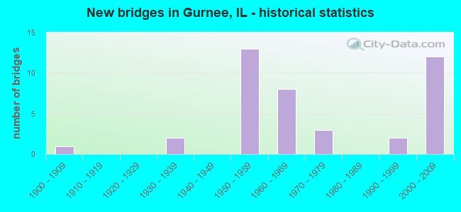
- New bridges - historical statistics
- 11900-1909
- 21930-1939
- 131950-1959
- 81960-1969
- 31970-1979
- 21990-1999
- 122000-2009

- Reconstructed bridges - Historical Statistics
- 11970-1979
- 01980-1989
- 31990-1999
- 42000-2009


- Bridge Condition - Deck
- 4.3%Very good
- 39.1%Good
- 34.8%Satisfactory
- 8.7%Fair
- 13.0%Poor

- Bridge Condition - Superstructure
- 13.0%Very good
- 30.4%Good
- 39.1%Satisfactory
- 17.4%Fair

- Bridge Condition - Substructure
- 34.8%Very good
- 13.0%Good
- 30.4%Satisfactory
- 21.7%Fair

- Bridge Condition - Channel
- 11.8%Very good
- 47.1%Good
- 35.3%Satisfactory
- 5.9%Fair

- Bridge Condition - Culverts
- 66.7%Good
- 33.3%Satisfactory
Find on map >> Show street view
Structure Number: 490016, Location: 1 M S OF IL 132 (Lat: 42.359589, Lng: -87.895972), Route carried "on" structure: Other road , Year Built: 1961, Year Reconstructed: 1996, Status: Open, Structure Length: 6.28m (20.60ft), Average Daily Traffic: 38,900 (year 2019), Truck Traffic: 3%, Average Future Daily Traffic: 30,051 (year 2032), Design Load: HS 20, Features Intersected: US 41, Facility Carried by Structure: WASHINGTON ST
Minimum Vertical Clearance: 30+ m (98+ ft), Kilometerpoint: 10.847, Lanes on structure: 4, Lanes under structure: 5, Base Highway Network: Yes, Owner: State Highway Agency, Approaching Roadway Width: 21.9m (71.9ft), Skew: 30 degrees, Material/Design: Steel continuous, Design/Construction: Stringer/Multi-beam, Number Of Spans In Main Unit: 4, Length of Maximum Span: 19.5m (64.0ft), Curb-To-Curb Width: 18.3m (60.0ft), Out-to-Out Width: 20.1m (65.9ft)
Condition: Deck: Satisfactory, Superstructure: Fair, Substructure: Fair, Operating Rating: 58.0 metric tons, Method Used To Determine Operating Rating: Load Factor (LF) rating reported by rating factor (RF) method using MS18 loading, Inventory Rating: 35.0 metric tons, Method Used To Determine Inventory Rating: Load Factor (LF) rating reported by rating factor (RF) method using MS18 loading, Structural Evaluation: Somewhat better than minimum adequacy, Deck Geometry: Somewhat better than minimum adequacy, Underclear: High priority of corrective action, Approach Roadway Alignment: Equal to present minimum criteria, Length Of Structure Improvement: 6.28m (20.60ft), Designated Inspection Frequency: Every 24 months, Inspection Date: June 2021, Bridge Improvement Cost: $897,000, Roadway Improvement Cost: $90,000, Total Project Cost: $1,346,000, Deck Structure Type: Concrete Cast-file-Place, Wearing Surface/Protective System: Deck Protection: Epoxy Coated Reinforcing
Find on map >> Show street view
Structure Number: 490029, Location: 0.7 M S OF IL 21 (Lat: 42.380081, Lng: -87.916489), Route carried "on" structure: US 41, Year Built: 1936, Year Reconstructed: 1981, Status: Open, Structure Length: 4.63m (15.19ft), Average Daily Traffic: 18,400 (year 2021), Truck Traffic: 12%, Average Future Daily Traffic: 27,269 (year 2032), Design Load: HS 20, Features Intersected: DES PLAINES RIVER
Minimum Vertical Clearance: 30+ m (98+ ft), Kilometerpoint: 89.236, Lanes on structure: 4, Base Highway Network: Yes, Owner: State Highway Agency, Approaching Roadway Width: 24.7m (81.0ft), Skew: 32 degrees, Material/Design: Steel continuous, Design/Construction: Stringer/Multi-beam, Number Of Spans In Main Unit: 3, Length of Maximum Span: 16.8m (55.1ft), Curb-To-Curb Width: 20.7m (67.9ft), Out-to-Out Width: 25.3m (83.0ft)
Condition: Deck: Satisfactory, Superstructure: Satisfactory, Substructure: Satisfactory, Channel: Good, Operating Rating: 78.7 metric tons, Method Used To Determine Operating Rating: Load Factor (LF) rating reported by rating factor (RF) method using MS18 loading, Inventory Rating: 42.4 metric tons, Method Used To Determine Inventory Rating: Load Factor (LF) rating reported by rating factor (RF) method using MS18 loading, Structural Evaluation: Equal to present minimum criteria, Deck Geometry: Superior to present desirable criteria, Waterway Adequacy: Meets minimum limits, Approach Roadway Alignment: Equal to present minimum criteria, Designated Inspection Frequency: Every 24 months, Inspection Date: September 2021, Deck Structure Type: Concrete Cast-file-Place, Wearing Surface/Protective System: Wearing Surface: Epoxy Overlay, Deck Protection: Epoxy Coated Reinforcing
Find on map >> Show street view
Structure Number: 490044, Location: 0.1 M W OF IL 21 (Lat: 42.343297, Lng: -87.947186), Route carried "on" structure: State highway 120, Year Built: 1960, Status: Open, Structure Length: 0.96m (3.15ft), Average Daily Traffic: 25,900 (year 2021), Truck Traffic: 6%, Average Future Daily Traffic: 18,587 (year 2032), Design Load: HS 20, Features Intersected: STREAM
Minimum Vertical Clearance: 30+ m (98+ ft), Kilometerpoint: 46.654, Lanes on structure: 2, Base Highway Network: Yes, Owner: State Highway Agency, Approaching Roadway Width: 8.5m (27.9ft), Skew: 2 degrees, Material/Design: Concrete, Design/Construction: Slab, Number Of Spans In Main Unit: 1, Length of Maximum Span: 9.1m (29.9ft), Curb-To-Curb Width: 11.6m (38.1ft), Out-to-Out Width: 12.9m (42.3ft)
Condition: Deck: Fair, Superstructure: Satisfactory, Substructure: Fair, Channel: Satisfactory, Operating Rating: 54.1 metric tons, Method Used To Determine Operating Rating: Load Factor (LF) rating reported by rating factor (RF) method using MS18 loading, Inventory Rating: 32.4 metric tons, Method Used To Determine Inventory Rating: Load Factor (LF) rating reported by rating factor (RF) method using MS18 loading, Structural Evaluation: Somewhat better than minimum adequacy, Deck Geometry: Better than present minimum criteria, Waterway Adequacy: Better than present minimum criteria, Approach Roadway Alignment: Equal to present desirable criteria, Length Of Structure Improvement: 0.98m (3.22ft), Designated Inspection Frequency: Every 24 months, Other Special Inspection Frequency: Every 12 months, Inspection Date: December 2021, Other Special Inspection Date: December 2021, Bridge Improvement Cost: $96,000, Roadway Improvement Cost: $10,000, Total Project Cost: $144,000, Deck Structure Type: Concrete Cast-file-Place, Wearing Surface/Protective System: Wearing Surface: Bituminous
Find on map >> Show street view
Structure Number: 490045, Location: 0.1 M W OF IL 21 (Lat: 42.343272, Lng: -87.947381), Route carried "on" structure: State highway 120, Year Built: 1960, Year Reconstructed: 2003, Status: Open, Structure Length: 0.93m (3.05ft), Average Daily Traffic: 25,900 (year 2021), Truck Traffic: 6%, Average Future Daily Traffic: 18,587 (year 2032), Design Load: HS 20, Features Intersected: STREAM
Minimum Vertical Clearance: 30+ m (98+ ft), Kilometerpoint: 46.670, Lanes on structure: 3, Base Highway Network: Yes, Owner: State Highway Agency, Approaching Roadway Width: 13.1m (43.0ft), Skew: 1 degrees, Material/Design: Concrete, Design/Construction: Slab, Number Of Spans In Main Unit: 1, Length of Maximum Span: 9.3m (30.5ft), Curb-To-Curb Width: 18.3m (60.0ft), Out-to-Out Width: 19.9m (65.3ft)
Condition: Deck: Satisfactory, Superstructure: Satisfactory, Substructure: Fair, Channel: Good, Operating Rating: 54.1 metric tons, Method Used To Determine Operating Rating: Load Factor (LF) rating reported by rating factor (RF) method using MS18 loading, Inventory Rating: 32.4 metric tons, Method Used To Determine Inventory Rating: Load Factor (LF) rating reported by rating factor (RF) method using MS18 loading, Structural Evaluation: Somewhat better than minimum adequacy, Deck Geometry: Superior to present desirable criteria, Waterway Adequacy: Better than present minimum criteria, Approach Roadway Alignment: Equal to present desirable criteria, Length Of Structure Improvement: 0.98m (3.22ft), Designated Inspection Frequency: Every 24 months, Other Special Inspection Frequency: Every 12 months, Inspection Date: December 2021, Other Special Inspection Date: December 2021, Bridge Improvement Cost: $96,000, Roadway Improvement Cost: $10,000, Total Project Cost: $144,000, Deck Structure Type: Concrete Cast-file-Place, Wearing Surface/Protective System: Wearing Surface: Other
Find on map >> Show street view
Structure Number: 490046, Location: 2.6 M W OF US 41 (Lat: 42.343897, Lng: -87.941283), Route carried "on" structure: State highway 120, Year Built: 1959, Status: Open, Structure Length: 5.33m (17.49ft), Average Daily Traffic: 29,800 (year 2021), Truck Traffic: 6%, Average Future Daily Traffic: 20,257 (year 2032), Design Load: HS 20, Features Intersected: DES PLAINES RIVER
Minimum Vertical Clearance: 30+ m (98+ ft), Kilometerpoint: 46.155, Lanes on structure: 2, Base Highway Network: Yes, Owner: State Highway Agency, Approaching Roadway Width: 10.4m (34.1ft), Skew: 2 degrees, Material/Design: Steel continuous, Design/Construction: Stringer/Multi-beam, Number Of Spans In Main Unit: 3, Length of Maximum Span: 21.0m (68.9ft), Curb-To-Curb Width: 11.9m (39.0ft), Out-to-Out Width: 13.7m (44.9ft)
Condition: Deck: Poor, Superstructure: Fair, Substructure: Satisfactory, Channel: Satisfactory, Operating Rating: 67.1 metric tons, Method Used To Determine Operating Rating: Load Factor (LF) rating reported by rating factor (RF) method using MS18 loading, Inventory Rating: 36.0 metric tons, Method Used To Determine Inventory Rating: Load Factor (LF) rating reported by rating factor (RF) method using MS18 loading, Structural Evaluation: Somewhat better than minimum adequacy, Deck Geometry: Better than present minimum criteria, Waterway Adequacy: Better than present minimum criteria, Approach Roadway Alignment: Equal to present desirable criteria, Designated Inspection Frequency: Every 24 months, Inspection Date: August 2020, Deck Structure Type: Concrete Cast-file-Place, Wearing Surface/Protective System: Wearing Surface: Bituminous, Membrane: Built-up
Find on map >> Show street view
Structure Number: 490047, Location: 2.5 M W OF US 41 (Lat: 42.343914, Lng: -87.941083), Route carried "on" structure: State highway 120, Year Built: 1959, Status: Open, Structure Length: 5.33m (17.49ft), Average Daily Traffic: 29,800 (year 2021), Truck Traffic: 6%, Average Future Daily Traffic: 20,257 (year 2032), Design Load: HS 20, Features Intersected: DES PLAINES RIVER
Minimum Vertical Clearance: 30+ m (98+ ft), Kilometerpoint: 46.139, Lanes on structure: 2, Base Highway Network: Yes, Owner: State Highway Agency, Approaching Roadway Width: 10.4m (34.1ft), Skew: 2 degrees, Material/Design: Steel continuous, Design/Construction: Stringer/Multi-beam, Number Of Spans In Main Unit: 3, Length of Maximum Span: 21.0m (68.9ft), Curb-To-Curb Width: 8.5m (27.9ft), Out-to-Out Width: 10.4m (34.1ft)
Condition: Deck: Poor, Superstructure: Fair, Substructure: Satisfactory, Channel: Good, Operating Rating: 64.8 metric tons, Method Used To Determine Operating Rating: Load Factor (LF) rating reported by rating factor (RF) method using MS18 loading, Inventory Rating: 34.7 metric tons, Method Used To Determine Inventory Rating: Load Factor (LF) rating reported by rating factor (RF) method using MS18 loading, Structural Evaluation: Somewhat better than minimum adequacy, Deck Geometry: High priority of corrective action, Waterway Adequacy: Better than present minimum criteria, Approach Roadway Alignment: Equal to present desirable criteria, Length Of Structure Improvement: 6.55m (21.49ft), Designated Inspection Frequency: Every 24 months, Inspection Date: August 2020, Bridge Improvement Cost: $803,000, Roadway Improvement Cost: $80,000, Total Project Cost: $1,205,000, Deck Structure Type: Concrete Cast-file-Place, Wearing Surface/Protective System: Wearing Surface: Bituminous, Membrane: Built-up
Find on map >> Show street view
Structure Number: 490053, Location: INTERS ILL 120 & 21 (Lat: 42.343544, Lng: -87.948281), Route carried "on" structure: Other road , Year Built: 1961, Status: Open, Structure Length: 0.91m (2.99ft), Average Daily Traffic: 1,800 (year 2019), Truck Traffic: 12%, Average Future Daily Traffic: 1,948 (year 2032), Design Load: HS 20, Features Intersected: STREAM, Facility Carried by Structure: IL 120 NW RMP @ IL
Minimum Vertical Clearance: 30+ m (98+ ft), Kilometerpoint: 0.322, Lanes on structure: 1, Base Highway Network: Yes, Owner: State Highway Agency, Approaching Roadway Width: 8.5m (27.9ft), Material/Design: Concrete, Design/Construction: Slab, Number Of Spans In Main Unit: 1, Length of Maximum Span: 8.8m (28.9ft), Curb-To-Curb Width: 9.4m (30.8ft), Out-to-Out Width: 10.5m (34.4ft)
Condition: Deck: Satisfactory, Superstructure: Satisfactory, Substructure: Satisfactory, Channel: Satisfactory, Operating Rating: 56.4 metric tons, Method Used To Determine Operating Rating: Load Factor (LF) rating reported by rating factor (RF) method using MS18 loading, Inventory Rating: 33.7 metric tons, Method Used To Determine Inventory Rating: Load Factor (LF) rating reported by rating factor (RF) method using MS18 loading, Structural Evaluation: Equal to present minimum criteria, Deck Geometry: Somewhat better than minimum adequacy, Waterway Adequacy: Equal to present desirable criteria, Approach Roadway Alignment: Equal to present desirable criteria, Designated Inspection Frequency: Every 24 months, Other Special Inspection Frequency: Every 12 months, Inspection Date: December 2021, Other Special Inspection Date: December 2021, Deck Structure Type: Concrete Cast-file-Place, Wearing Surface/Protective System: Wearing Surface: Bituminous, Membrane: Built-up
Find on map >> Show street view
Structure Number: 490062, Location: 0.2 M E OF IL 21 (Lat: 42.372169, Lng: -87.922083), Route carried "on" structure: State highway 132, Year Built: 1957, Year Reconstructed: 2014, Status: Open, Structure Length: 4.00m (13.12ft), Average Daily Traffic: 21,500 (year 2021), Truck Traffic: 3%, Average Future Daily Traffic: 31,943 (year 2032), Design Load: HS 20, Features Intersected: DES PLAINES RIVER
Minimum Vertical Clearance: 30+ m (98+ ft), Kilometerpoint: 18.443, Lanes on structure: 4, Base Highway Network: Yes, Owner: State Highway Agency, Approaching Roadway Width: 17.7m (58.1ft), Skew: 3 degrees, Material/Design: Prestressed concrete, Design/Construction: Box Beam or Girders - Multiple, Number Of Spans In Main Unit: 3, Length of Maximum Span: 13.4m (44.0ft), Curb or Sidewalk Widths: Left: 1.2m (3.9ft), Right: 1.2m (3.9ft), Curb-To-Curb Width: 17.7m (58.1ft), Out-to-Out Width: 23.2m (76.1ft)
Condition: Deck: Good, Superstructure: Satisfactory, Substructure: Satisfactory, Channel: Very good, Operating Rating: 89.1 metric tons, Method Used To Determine Operating Rating: Load Factor (LF) rating reported by rating factor (RF) method using MS18 loading, Inventory Rating: 70.6 metric tons, Method Used To Determine Inventory Rating: Load Factor (LF) rating reported by rating factor (RF) method using MS18 loading, Structural Evaluation: Equal to present minimum criteria, Deck Geometry: Somewhat better than minimum adequacy, Waterway Adequacy: Somewhat better than minimum adequacy, Approach Roadway Alignment: Equal to present desirable criteria, Length Of Structure Improvement: 4.85m (15.91ft), Designated Inspection Frequency: Every 24 months, Inspection Date: July 2021, Bridge Improvement Cost: $653,000, Roadway Improvement Cost: $65,000, Total Project Cost: $980,000, Deck Structure Type: Concrete Cast-file-Place, Wearing Surface/Protective System: Deck Protection: Epoxy Coated Reinforcing
Find on map >> Show street view
Structure Number: 490114, Location: .2M E OF ILL 21 (Lat: 42.362328, Lng: -87.926231), Route carried "on" structure: Other road , Year Built: 1972, Year Reconstructed: 2008, Status: Open, Structure Length: 5.19m (17.03ft), Average Daily Traffic: 15,600 (year 2019), Truck Traffic: 4%, Average Future Daily Traffic: 12,800 (year 2032), Design Load: HS 20, Features Intersected: DESPLAINES RIVER, Facility Carried by Structure: WASHINGTON STREET
Minimum Vertical Clearance: 30+ m (98+ ft), Kilometerpoint: 8.288, Lanes on structure: 2, Base Highway Network: Yes, Owner: County Highway Agency, Approaching Roadway Width: 11.6m (38.1ft), Material/Design: Prestressed concrete, Design/Construction: Box Beam or Girders - Multiple, Number Of Spans In Main Unit: 3, Length of Maximum Span: 30.5m (100.1ft), Curb-To-Curb Width: 10.5m (34.4ft), Out-to-Out Width: 11.4m (37.4ft)
Condition: Deck: Good, Superstructure: Very good, Substructure: Very good, Channel: Good, Operating Rating: 58.0 metric tons, Method Used To Determine Operating Rating: Load Factor (LF) rating reported by rating factor (RF) method using MS18 loading, Inventory Rating: 34.7 metric tons, Method Used To Determine Inventory Rating: Load Factor (LF) rating reported by rating factor (RF) method using MS18 loading, Structural Evaluation: Equal to present desirable criteria, Deck Geometry: Somewhat better than minimum adequacy, Waterway Adequacy: Equal to present desirable criteria, Approach Roadway Alignment: Equal to present desirable criteria, Designated Inspection Frequency: Every 48 months, Inspection Date: April 2020, Deck Structure Type: Concrete Cast-file-Place, Wearing Surface/Protective System: Wearing Surface: Other
Find on map >> Show street view
Structure Number: 490115, Location: .2M E OF ILL 21 (Lat: 42.362247, Lng: -87.926069), Route carried "on" structure: Other road , Year Built: 1972, Year Reconstructed: 2009, Status: Open, Structure Length: 5.19m (17.03ft), Average Daily Traffic: 15,600 (year 2019), Truck Traffic: 4%, Average Future Daily Traffic: 12,800 (year 2032), Design Load: HS 20, Features Intersected: DESPLAINES RIVER, Facility Carried by Structure: WASHINGTON STREET
Minimum Vertical Clearance: 30+ m (98+ ft), Kilometerpoint: 8.304, Lanes on structure: 2, Base Highway Network: Yes, Owner: County Highway Agency, Approaching Roadway Width: 9.8m (32.2ft), Material/Design: Prestressed concrete, Design/Construction: Box Beam or Girders - Multiple, Number Of Spans In Main Unit: 3, Length of Maximum Span: 30.5m (100.1ft), Curb-To-Curb Width: 9.8m (32.2ft), Out-to-Out Width: 14.0m (45.9ft)
Condition: Deck: Good, Superstructure: Good, Substructure: Good, Channel: Good, Operating Rating: 51.8 metric tons, Method Used To Determine Operating Rating: Load Factor (LF) rating reported by rating factor (RF) method using MS18 loading, Inventory Rating: 31.1 metric tons, Method Used To Determine Inventory Rating: Load Factor (LF) rating reported by rating factor (RF) method using MS18 loading, Structural Evaluation: Better than present minimum criteria, Deck Geometry: Meets minimum limits, Waterway Adequacy: Equal to present desirable criteria, Approach Roadway Alignment: Equal to present desirable criteria, Designated Inspection Frequency: Every 48 months, Inspection Date: April 2020, Deck Structure Type: Concrete Cast-file-Place, Wearing Surface/Protective System: Wearing Surface: Other
Find on map >> Show street view
Structure Number: 490179, Location: 1 M W OF I-94 (Lat: 42.343722, Lng: -87.945261), Route carried "on" structure: State highway 21, Year Built: 2003, Status: Open, Structure Length: 16.40m (53.81ft), Average Daily Traffic: 21,100 (year 2021), Truck Traffic: 5%, Average Future Daily Traffic: 23,707 (year 2032), Design Load: HS 20, Features Intersected: IL 120 & STREAM
Minimum Vertical Clearance: 30+ m (98+ ft), Kilometerpoint: 39.734, Lanes on structure: 4, Lanes under structure: 6, Base Highway Network: Yes, Owner: State Highway Agency, Approaching Roadway Width: 14.6m (47.9ft), Skew: 33 degrees, Material/Design: Steel continuous, Design/Construction: Stringer/Multi-beam, Number Of Spans In Main Unit: 2, Length of Maximum Span: 72.5m (237.9ft), Curb or Sidewalk Widths: Left: 2.1m (6.9ft), Right: 0.0m, Curb-To-Curb Width: 15.8m (51.8ft), Out-to-Out Width: 24.3m (79.7ft)
Condition: Deck: Good, Superstructure: Good, Substructure: Very good, Channel: Good, Operating Rating: 61.9 metric tons, Method Used To Determine Operating Rating: Load Factor (LF) rating reported by rating factor (RF) method using MS18 loading, Inventory Rating: 37.3 metric tons, Method Used To Determine Inventory Rating: Load Factor (LF) rating reported by rating factor (RF) method using MS18 loading, Structural Evaluation: Better than present minimum criteria, Deck Geometry: Meets minimum limits, Underclear: Meets minimum limits, Waterway Adequacy: Equal to present desirable criteria, Approach Roadway Alignment: Equal to present desirable criteria, Designated Inspection Frequency: Every 24 months, Other Special Inspection Frequency: Every 72 months, Inspection Date: April 2021, Other Special Inspection Date: January 2020, Deck Structure Type: Other, Wearing Surface/Protective System: Deck Protection: Epoxy Coated Reinforcing
Find on map >> Show street view
Structure Number: 490192, Location: 0.25 M S I-94 (Lat: 42.354244, Lng: -87.937417), Route carried "on" structure: State highway 21, Year Built: 2003, Status: Open, Structure Length: 1.18m (3.87ft), Average Daily Traffic: 21,100 (year 2021), Truck Traffic: 5%, Average Future Daily Traffic: 23,707 (year 2032), Design Load: HS 20, Features Intersected: STREAM
Minimum Vertical Clearance: 30+ m (98+ ft), Kilometerpoint: 41.021, Lanes on structure: 4, Base Highway Network: Yes, Owner: State Highway Agency, Approaching Roadway Width: 17.1m (56.1ft), Skew: 32 degrees, Material/Design: Concrete continuous, Design/Construction: Culvert, Number Of Spans In Main Unit: 3, Length of Maximum Span: 3.4m (11.2ft), Curb or Sidewalk Widths: Left: 0.0m, Right: 1.5m (4.9ft)
Condition: Channel: Fair, Culverts: Good, Operating Rating: 78.7 metric tons, Method Used To Determine Operating Rating: Load Factor (LF) rating reported by rating factor (RF) method using MS18 loading, Inventory Rating: 47.3 metric tons, Method Used To Determine Inventory Rating: Load Factor (LF) rating reported by rating factor (RF) method using MS18 loading, Structural Evaluation: Better than present minimum criteria, Waterway Adequacy: Equal to present desirable criteria, Approach Roadway Alignment: Equal to present desirable criteria, Designated Inspection Frequency: Every 48 months, Inspection Date: January 2020
Find on map >> Show street view
Structure Number: 490209, Location: US 41 & ILL 132 INT. (Lat: 42.370311, Lng: -87.896100), Route carried "on" structure: US 41, Year Built: 2009, Status: Open, Structure Length: 21.12m (69.29ft), Average Daily Traffic: 20,800 (year 2021), Truck Traffic: 12%, Average Future Daily Traffic: 43,964 (year 2032), Design Load: HS 20, Features Intersected: IL 132 (GRAND AVE)
Minimum Vertical Clearance: 30+ m (98+ ft), Kilometerpoint: 87.047, Lanes on structure: 4, Lanes under structure: 2, Base Highway Network: Yes, Owner: State Highway Agency, Approaching Roadway Width: 26.9m (88.3ft), Skew: 2 degrees, Material/Design: Steel continuous, Design/Construction: Stringer/Multi-beam, Number Of Spans In Main Unit: 3, Length of Maximum Span: 91.4m (299.9ft), Curb-To-Curb Width: 26.9m (88.3ft), Out-to-Out Width: 28.7m (94.2ft)
Condition: Deck: Good, Superstructure: Very good, Substructure: Very good, Operating Rating: 75.5 metric tons, Method Used To Determine Operating Rating: Load Factor (LF) rating reported by rating factor (RF) method using MS18 loading, Inventory Rating: 45.0 metric tons, Method Used To Determine Inventory Rating: Load Factor (LF) rating reported by rating factor (RF) method using MS18 loading, Structural Evaluation: Equal to present desirable criteria, Deck Geometry: Superior to present desirable criteria, Underclear: High priority of corrective action, Approach Roadway Alignment: Equal to present desirable criteria, Designated Inspection Frequency: Every 24 months, Inspection Date: July 2021, Deck Structure Type: Concrete Cast-file-Place, Wearing Surface/Protective System: Deck Protection: Epoxy Coated Reinforcing
Find on map >> Show street view
Structure Number: 490211, Location: IL 132 & O'PLAIN (Lat: 42.369614, Lng: -87.914639), Route carried "on" structure: State highway 132, Year Built: 1962, Status: Open, Structure Length: 1.22m (4.00ft), Average Daily Traffic: 21,500 (year 2021), Truck Traffic: 3%, Average Future Daily Traffic: 31,943 (year 2032), Features Intersected: CREEK
Minimum Vertical Clearance: 30+ m (98+ ft), Kilometerpoint: 19.086, Lanes on structure: 5, Base Highway Network: Yes, Owner: State Highway Agency, Approaching Roadway Width: 18.3m (60.0ft), Skew: 6 degrees, Material/Design: Steel, Design/Construction: Culvert, Number Of Spans In Main Unit: 1, Length of Maximum Span: 6.1m (20.0ft)
Condition: Channel: Satisfactory, Culverts: Good, Operating Rating: 97.2 metric tons, Method Used To Determine Operating Rating: Load Factor (LF) rating reported by rating factor (RF) method using MS18 loading, Inventory Rating: 97.2 metric tons, Method Used To Determine Inventory Rating: Load Factor (LF) rating reported by rating factor (RF) method using MS18 loading, Structural Evaluation: Better than present minimum criteria, Waterway Adequacy: Equal to present desirable criteria, Approach Roadway Alignment: Equal to present desirable criteria, Designated Inspection Frequency: Every 24 months, Inspection Date: October 2020
Find on map >> Show street view
Structure Number: 49022, Location: 3.0 M N IL 120 (Lat: 42.381161, Lng: -87.948011), Route carried "on" structure: State highway 132, Year Built: 2009, Status: Open, Structure Length: 9.85m (32.32ft), Average Daily Traffic: 42,600 (year 2021), Truck Traffic: 4%, Average Future Daily Traffic: 48,304 (year 2032), Design Load: HS 20, Features Intersected: I- 94 TRI STATE TOLL
Minimum Vertical Clearance: 30+ m (98+ ft), Kilometerpoint: 16.061, Lanes on structure: 6, Lanes under structure: 10, Base Highway Network: Yes, Owner: State Highway Agency, Approaching Roadway Width: 25.6m (84.0ft), Skew: 34 degrees, Material/Design: Steel continuous, Design/Construction: Stringer/Multi-beam, Number Of Spans In Main Unit: 2, Length of Maximum Span: 49.2m (161.4ft), Curb-To-Curb Width: 25.6m (84.0ft), Out-to-Out Width: 27.8m (91.2ft)
Condition: Deck: Satisfactory, Superstructure: Good, Substructure: Good, Operating Rating: 90.7 metric tons, Method Used To Determine Operating Rating: Load Factor (LF) rating reported by rating factor (RF) method using MS18 loading, Inventory Rating: 54.4 metric tons, Method Used To Determine Inventory Rating: Load Factor (LF) rating reported by rating factor (RF) method using MS18 loading, Structural Evaluation: Better than present minimum criteria, Deck Geometry: Somewhat better than minimum adequacy, Underclear: Meets minimum limits, Approach Roadway Alignment: Better than present minimum criteria, Designated Inspection Frequency: Every 24 months, Inspection Date: May 2019, Deck Structure Type: Concrete Cast-file-Place, Wearing Surface/Protective System: Deck Protection: Epoxy Coated Reinforcing
Find on map >> Show street view
Structure Number: 490221, Location: 1.6 M W OF US 41 (Lat: 42.345500, Lng: -87.922728), Route carried "on" structure: State highway 120, Year Built: 2008, Status: Open, Structure Length: 7.08m (23.23ft), Average Daily Traffic: 31,300 (year 2021), Truck Traffic: 8%, Average Future Daily Traffic: 19,255 (year 2032), Design Load: HS 20, Features Intersected: I- 94 TRI STATE TOLL
Minimum Vertical Clearance: 30+ m (98+ ft), Kilometerpoint: 44.658, Lanes on structure: 2, Lanes under structure: 8, Base Highway Network: Yes, Owner: State Highway Agency, Approaching Roadway Width: 12.2m (40.0ft), Skew: 2 degrees, Material/Design: Prestressed concrete continuous, Design/Construction: Stringer/Multi-beam, Number Of Spans In Main Unit: 2, Length of Maximum Span: 34.2m (112.2ft), Curb-To-Curb Width: 12.2m (40.0ft), Out-to-Out Width: 13.2m (43.3ft)
Condition: Deck: Very good, Superstructure: Good, Substructure: Very good, Operating Rating: 60.3 metric tons, Method Used To Determine Operating Rating: Load Factor (LF) rating reported by rating factor (RF) method using MS18 loading, Inventory Rating: 36.0 metric tons, Method Used To Determine Inventory Rating: Load Factor (LF) rating reported by rating factor (RF) method using MS18 loading, Structural Evaluation: Better than present minimum criteria, Deck Geometry: Better than present minimum criteria, Underclear: Equal to present minimum criteria, Approach Roadway Alignment: Equal to present desirable criteria, Designated Inspection Frequency: Every 24 months, Inspection Date: June 2019, Deck Structure Type: Concrete Cast-file-Place, Wearing Surface/Protective System: Deck Protection: Epoxy Coated Reinforcing
Find on map >> Show street view
Structure Number: 490222, Location: 1.6 M W OF US 41 (Lat: 42.345514, Lng: -87.922536), Route carried "on" structure: State highway 120, Year Built: 2008, Status: Open, Structure Length: 7.08m (23.23ft), Average Daily Traffic: 31,300 (year 2021), Truck Traffic: 8%, Average Future Daily Traffic: 19,255 (year 2032), Design Load: HS 20, Features Intersected: I- 94 TRI STATE TOLL
Minimum Vertical Clearance: 30+ m (98+ ft), Kilometerpoint: 44.642, Lanes on structure: 3, Lanes under structure: 8, Base Highway Network: Yes, Owner: State Highway Agency, Approaching Roadway Width: 15.8m (51.8ft), Skew: 2 degrees, Material/Design: Prestressed concrete continuous, Design/Construction: Stringer/Multi-beam, Number Of Spans In Main Unit: 2, Length of Maximum Span: 34.2m (112.2ft), Curb-To-Curb Width: 15.8m (51.8ft), Out-to-Out Width: 16.8m (55.1ft)
Condition: Deck: Good, Superstructure: Very good, Substructure: Very good, Operating Rating: 60.6 metric tons, Method Used To Determine Operating Rating: Load Factor (LF) rating reported by rating factor (RF) method using MS18 loading, Inventory Rating: 36.3 metric tons, Method Used To Determine Inventory Rating: Load Factor (LF) rating reported by rating factor (RF) method using MS18 loading, Structural Evaluation: Equal to present desirable criteria, Deck Geometry: Better than present minimum criteria, Underclear: Equal to present minimum criteria, Approach Roadway Alignment: Equal to present desirable criteria, Designated Inspection Frequency: Every 24 months, Inspection Date: June 2019, Deck Structure Type: Concrete Cast-file-Place, Wearing Surface/Protective System: Deck Protection: Epoxy Coated Reinforcing
Find on map >> Show street view
Structure Number: 496162, Location: 990 E HUNT CLUB DR (Lat: 42.348689, Lng: -87.960069), Route carried "on" structure: City street , Year Built: 2007, Status: Open, Structure Length: 1.22m (4.00ft), Average Daily Traffic: 200 (year 2019), Truck Traffic: 4%, Average Future Daily Traffic: 567 (year 2032), Design Load: HS 20, Features Intersected: SHERMAN COMER CREEK, Facility Carried by Structure: CUNNINGHAM COURT
Minimum Vertical Clearance: 30+ m (98+ ft), Kilometerpoint: 0.306, Lanes on structure: 2, Owner: City or Municipal Highway Agency, Approaching Roadway Width: 8.6m (28.2ft), Material/Design: Steel, Design/Construction: Stringer/Multi-beam, Number Of Spans In Main Unit: 1, Length of Maximum Span: 11.9m (39.0ft), Curb or Sidewalk Widths: Left: 3.7m (12.1ft), Right: 2.7m (8.9ft), Curb-To-Curb Width: 9.1m (29.9ft), Out-to-Out Width: 15.5m (50.9ft)
Condition: Deck: Poor, Superstructure: Satisfactory, Substructure: Very good, Channel: Very good, Operating Rating: 44.1 metric tons, Method Used To Determine Operating Rating: Assigned rating based on Load Factor Design (LFD) reported by rating factor (RF) using MS18 loading, Inventory Rating: 32.4 metric tons, Method Used To Determine Inventory Rating: Assigned rating based on Load Factor Design (LFD) reported by rating factor (RF) using MS18 loading, Structural Evaluation: Equal to present minimum criteria, Deck Geometry: Equal to present minimum criteria, Waterway Adequacy: Equal to present desirable criteria, Approach Roadway Alignment: Equal to present desirable criteria, Designated Inspection Frequency: Every 24 months, Inspection Date: July 2021, Deck Structure Type: Concrete Cast-file-Place
Find on map >> Show street view
Structure Number: 4964, Location: 700 FT N ILL RT 120 (Lat: 42.343289, Lng: -87.950414), Route carried "on" structure: City street , Year Built: 1977, Status: Posted for load, Structure Length: 2.13m (6.99ft), Average Daily Traffic: 900 (year 2019), Truck Traffic: 3%, Average Future Daily Traffic: 344 (year 2032), Design Load: H 15, Features Intersected: SPINNEY RUN CR, Facility Carried by Structure: LEONARD DR
Minimum Vertical Clearance: 5.03m (16.50ft), Kilometerpoint: 1.706, Lanes on structure: 2, Owner: City or Municipal Highway Agency, Approaching Roadway Width: 10.1m (33.1ft), Material/Design: Concrete, Design/Construction: Tee Beam, Number Of Spans In Main Unit: 3, Length of Maximum Span: 7.9m (25.9ft), Curb-To-Curb Width: 10.6m (34.8ft), Out-to-Out Width: 11.3m (37.1ft)
Condition: Deck: Satisfactory, Superstructure: Good, Substructure: Good, Channel: Good, Operating Rating: 20.4 metric tons, Method Used To Determine Operating Rating: Load Factor (LF) rating reported by rating factor (RF) method using MS18 loading, Inventory Rating: 12.3 metric tons, Method Used To Determine Inventory Rating: Load Factor (LF) rating reported by rating factor (RF) method using MS18 loading, Structural Evaluation: High priority of corrective action, Deck Geometry: Equal to present minimum criteria, Waterway Adequacy: Equal to present desirable criteria, Approach Roadway Alignment: Equal to present desirable criteria, Bridge Posting: Required (Relationship of Operating Rating to Maximum Legal Load: > 39.9% below), Designated Inspection Frequency: Every 24 months, Inspection Date: July 2021, Deck Structure Type: Other
Find on map >> Show street view
Structure Number: 496401, Location: 1800'S OF GAGE LK RD (Lat: 42.348167, Lng: -87.957308), Route carried "on" structure: City street , Year Built: 1992, Status: Open, Structure Length: 0.73m (2.40ft), Average Daily Traffic: 1,000 (year 2019), Truck Traffic: 3%, Average Future Daily Traffic: 1,113 (year 2032), Design Load: HS 20, Features Intersected: SHERMAN COMERS CREEK, Facility Carried by Structure: LEONARD DRIVE
Minimum Vertical Clearance: 30+ m (98+ ft), Kilometerpoint: 0.547, Lanes on structure: 2, Owner: City or Municipal Highway Agency, Approaching Roadway Width: 11.0m (36.1ft), Material/Design: Concrete, Design/Construction: Culvert, Number Of Spans In Main Unit: 2, Length of Maximum Span: 3.4m (11.2ft), Curb or Sidewalk Widths: Left: 0.0m, Right: 1.2m (3.9ft), Curb-To-Curb Width: 11.0m (36.1ft), Out-to-Out Width: 11.0m (36.1ft)
Condition: Channel: Satisfactory, Culverts: Satisfactory, Operating Rating: 44.1 metric tons, Method Used To Determine Operating Rating: Assigned rating based on Load Factor Design (LFD) reported by rating factor (RF) using MS18 loading, Inventory Rating: 32.4 metric tons, Method Used To Determine Inventory Rating: Assigned rating based on Load Factor Design (LFD) reported by rating factor (RF) using MS18 loading, Structural Evaluation: Equal to present minimum criteria, Deck Geometry: Better than present minimum criteria, Waterway Adequacy: Equal to present desirable criteria, Approach Roadway Alignment: Equal to present desirable criteria, Designated Inspection Frequency: Every 24 months, Inspection Date: July 2021
Find on map >> Show street view
Structure Number: 499901, Location: 1.2 M S OF IL 132 (Lat: 42.357983, Lng: -87.934775), Route carried "on" structure: State highway 21, Year Built: 1958, Year Reconstructed: 2003, Status: Open, Structure Length: 7.76m (25.46ft), Average Daily Traffic: 12,700 (year 2021), Truck Traffic: 5%, Average Future Daily Traffic: 18,810 (year 2032), Design Load: HS 20, Features Intersected: I- 94 TRI STATE TOLL
Minimum Vertical Clearance: 30+ m (98+ ft), Kilometerpoint: 41.520, Lanes on structure: 4, Lanes under structure: 6, Base Highway Network: Yes, Owner: State Highway Agency, Approaching Roadway Width: 22.1m (72.5ft), Skew: 32 degrees, Material/Design: Prestressed concrete continuous, Design/Construction: Stringer/Multi-beam, Number Of Spans In Main Unit: 4, Length of Maximum Span: 22.5m (73.8ft), Curb or Sidewalk Widths: Left: 2.1m (6.9ft), Right: 0.0m, Curb-To-Curb Width: 18.4m (60.4ft), Out-to-Out Width: 24.7m (81.0ft)
Condition: Deck: Good, Superstructure: Fair, Substructure: Fair, Operating Rating: 77.8 metric tons, Method Used To Determine Operating Rating: Load Factor (LF) rating reported by rating factor (RF) method using MS18 loading, Inventory Rating: 46.7 metric tons, Method Used To Determine Inventory Rating: Load Factor (LF) rating reported by rating factor (RF) method using MS18 loading, Structural Evaluation: Somewhat better than minimum adequacy, Deck Geometry: Somewhat better than minimum adequacy, Underclear: Meets minimum limits, Approach Roadway Alignment: Equal to present desirable criteria, Length Of Structure Improvement: 7.53m (24.70ft), Designated Inspection Frequency: Every 24 months, Inspection Date: May 2020, Bridge Improvement Cost: $317,000, Roadway Improvement Cost: $32,000, Total Project Cost: $380,000, Deck Structure Type: Concrete Cast-file-Place, Wearing Surface/Protective System: Deck Protection: Epoxy Coated Reinforcing
Find on map >> Show street view
Structure Number: 499912, Location: I94 .8M N ILL 132 (Lat: 42.393483, Lng: -87.949125), Route carried "on" structure: Other road , Year Built: 1958, Year Reconstructed: 2009, Status: Open, Structure Length: 7.10m (23.29ft), Average Daily Traffic: 15,900 (year 2019), Truck Traffic: 4%, Average Future Daily Traffic: 16,695 (year 2032), Design Load: HS 20, Features Intersected: INTERSTATE 94, Facility Carried by Structure: STEARNS SCHOOL RD
Minimum Vertical Clearance: 30+ m (98+ ft), Kilometerpoint: 3.251, Lanes on structure: 2, Lanes under structure: 6, Base Highway Network: Yes, Owner: City or Municipal Highway Agency, Approaching Roadway Width: 7.9m (25.9ft), Material/Design: Prestressed concrete, Design/Construction: Stringer/Multi-beam, Number Of Spans In Main Unit: 4, Length of Maximum Span: 20.1m (65.9ft), Curb or Sidewalk Widths: Left: 0.6m (2.0ft), Right: 0.6m (2.0ft), Curb-To-Curb Width: 7.3m (24.0ft), Out-to-Out Width: 9.3m (30.5ft)
Condition: Deck: Fair, Superstructure: Satisfactory, Substructure: Fair, Operating Rating: 58.3 metric tons, Method Used To Determine Operating Rating: Load Factor (LF) rating reported by rating factor (RF) method using MS18 loading, Inventory Rating: 35.0 metric tons, Method Used To Determine Inventory Rating: Load Factor (LF) rating reported by rating factor (RF) method using MS18 loading, Structural Evaluation: Somewhat better than minimum adequacy, Deck Geometry: High priority of replacement, Underclear: Equal to present minimum criteria, Approach Roadway Alignment: Superior to present desirable criteria, Length Of Structure Improvement: 7.80m (25.59ft), Designated Inspection Frequency: Every 24 months, Inspection Date: May 2020, Bridge Improvement Cost: $748,000, Roadway Improvement Cost: $75,000, Total Project Cost: $1,122,000, Deck Structure Type: Concrete Cast-file-Place, Wearing Surface/Protective System: Wearing Surface: Integral Concrete
Find on map >> Show street view
Structure Number: 499919, Location: I94 1.3M S ILL 132 (Lat: 42.363889, Lng: -87.939189), Route carried "on" structure: Interstate 94, Year Built: 1958, Status: Open, Structure Length: 4.11m (13.48ft), Average Daily Traffic: 41,150 (year 2020), Truck Traffic: 6%, Average Future Daily Traffic: 48,026 (year 2032), Design Load: HS 20, Features Intersected: WASHINGTON STREET
Minimum Vertical Clearance: 30+ m (98+ ft), Kilometerpoint: 15.642, Lanes on structure: 2, Lanes under structure: 2, Base Highway Network: Yes, Toll: On toll road, Owner: State Toll Authority, Approaching Roadway Width: 12.2m (40.0ft), Skew: 2 degrees, Material/Design: Prestressed concrete, Design/Construction: Stringer/Multi-beam, Number Of Spans In Main Unit: 3, Length of Maximum Span: 14.0m (45.9ft), Curb-To-Curb Width: 10.5m (34.4ft), Out-to-Out Width: 12.0m (39.4ft)
Condition: Deck: Satisfactory, Superstructure: Good, Substructure: Very good, Operating Rating: 71.0 metric tons, Method Used To Determine Operating Rating: Load Factor (LF) rating reported by rating factor (RF) method using MS18 loading, Inventory Rating: 42.4 metric tons, Method Used To Determine Inventory Rating: Load Factor (LF) rating reported by rating factor (RF) method using MS18 loading, Structural Evaluation: Better than present minimum criteria, Deck Geometry: Meets minimum limits, Underclear: High priority of corrective action, Approach Roadway Alignment: Better than present minimum criteria, Designated Inspection Frequency: Every 24 months, Inspection Date: June 2019, Deck Structure Type: Concrete Cast-file-Place
Find on map >> Show street view
Structure Number: 49992, Location: I94 1.3M S ILL 132 (Lat: 42.363661, Lng: -87.939081), Route carried "on" structure: Interstate 94, Year Built: 1958, Status: Open, Structure Length: 4.11m (13.48ft), Average Daily Traffic: 41,150 (year 2020), Truck Traffic: 6%, Average Future Daily Traffic: 48,026 (year 2032), Design Load: HS 20, Features Intersected: WASHINGTON STREET
Minimum Vertical Clearance: 30+ m (98+ ft), Kilometerpoint: 15.658, Lanes on structure: 2, Lanes under structure: 2, Base Highway Network: Yes, Toll: On toll road, Owner: State Toll Authority, Approaching Roadway Width: 12.2m (40.0ft), Skew: 2 degrees, Material/Design: Prestressed concrete, Design/Construction: Stringer/Multi-beam, Number Of Spans In Main Unit: 3, Length of Maximum Span: 14.0m (45.9ft), Curb-To-Curb Width: 10.5m (34.4ft), Out-to-Out Width: 12.0m (39.4ft)
Condition: Deck: Satisfactory, Superstructure: Good, Substructure: Very good, Operating Rating: 66.7 metric tons, Method Used To Determine Operating Rating: Load Factor (LF) rating reported by rating factor (RF) method using MS18 loading, Inventory Rating: 39.9 metric tons, Method Used To Determine Inventory Rating: Load Factor (LF) rating reported by rating factor (RF) method using MS18 loading, Structural Evaluation: Better than present minimum criteria, Deck Geometry: Meets minimum limits, Underclear: High priority of corrective action, Approach Roadway Alignment: Equal to present desirable criteria, Length Of Structure Improvement: 4.11m (13.48ft), Designated Inspection Frequency: Every 24 months, Inspection Date: June 2019, Bridge Improvement Cost: $336,000, Roadway Improvement Cost: $34,000, Total Project Cost: $504,000, Deck Structure Type: Concrete Cast-file-Place, Wearing Surface/Protective System: Wearing Surface: Bituminous, Membrane: Built-up
Find on map >> Show street view
Structure Number: 499921, Location: I94 .7M N ILL 120 (Lat: 42.353406, Lng: -87.930861), Route carried "on" structure: Interstate 94, Year Built: 1958, Status: Open, Structure Length: 6.16m (20.21ft), Average Daily Traffic: 37,300 (year 2021), Truck Traffic: 9%, Average Future Daily Traffic: 45,243 (year 2032), Design Load: HS 20, Features Intersected: DES PLAINES RIVER
Minimum Vertical Clearance: 30+ m (98+ ft), Kilometerpoint: 16.994, Lanes on structure: 2, Base Highway Network: Yes, Toll: On toll road, Owner: State Toll Authority, Approaching Roadway Width: 12.2m (40.0ft), Skew: 2 degrees, Material/Design: Prestressed concrete, Design/Construction: Stringer/Multi-beam, Number Of Spans In Main Unit: 3, Length of Maximum Span: 20.1m (65.9ft), Curb-To-Curb Width: 10.5m (34.4ft), Out-to-Out Width: 12.0m (39.4ft)
Condition: Deck: Good, Superstructure: Satisfactory, Substructure: Satisfactory, Channel: Satisfactory, Operating Rating: 64.5 metric tons, Method Used To Determine Operating Rating: Load Factor (LF) rating reported by rating factor (RF) method using MS18 loading, Inventory Rating: 38.6 metric tons, Method Used To Determine Inventory Rating: Load Factor (LF) rating reported by rating factor (RF) method using MS18 loading, Structural Evaluation: Equal to present minimum criteria, Deck Geometry: Meets minimum limits, Waterway Adequacy: Equal to present minimum criteria, Approach Roadway Alignment: Equal to present desirable criteria, Designated Inspection Frequency: Every 24 months, Underwater Inspection Frequency: Every 60 months, Inspection Date: June 2020, Underwater Inspection Date: April 2018, Deck Structure Type: Concrete Cast-file-Place, Wearing Surface/Protective System: Wearing Surface: Bituminous, Membrane: Built-up
Find on map >> Show street view
Structure Number: 499922, Location: I94 .7M N ILL 120 (Lat: 42.353283, Lng: -87.930747), Route carried "on" structure: Interstate 94, Year Built: 1958, Status: Open, Structure Length: 6.16m (20.21ft), Average Daily Traffic: 37,300 (year 2021), Truck Traffic: 9%, Average Future Daily Traffic: 45,243 (year 2032), Design Load: HS 20, Features Intersected: DES PLAINES RIVER
Minimum Vertical Clearance: 30+ m (98+ ft), Kilometerpoint: 17.010, Lanes on structure: 2, Base Highway Network: Yes, Toll: On toll road, Owner: State Toll Authority, Approaching Roadway Width: 12.2m (40.0ft), Skew: 2 degrees, Material/Design: Prestressed concrete, Design/Construction: Stringer/Multi-beam, Number Of Spans In Main Unit: 3, Length of Maximum Span: 20.1m (65.9ft), Curb-To-Curb Width: 10.5m (34.4ft), Out-to-Out Width: 12.0m (39.4ft)
Condition: Deck: Good, Superstructure: Satisfactory, Substructure: Satisfactory, Channel: Good, Operating Rating: 66.4 metric tons, Method Used To Determine Operating Rating: Load Factor (LF) rating reported by rating factor (RF) method using MS18 loading, Inventory Rating: 39.9 metric tons, Method Used To Determine Inventory Rating: Load Factor (LF) rating reported by rating factor (RF) method using MS18 loading, Structural Evaluation: Equal to present minimum criteria, Deck Geometry: Meets minimum limits, Waterway Adequacy: Equal to present desirable criteria, Approach Roadway Alignment: Equal to present desirable criteria, Designated Inspection Frequency: Every 24 months, Underwater Inspection Frequency: Every 60 months, Inspection Date: June 2020, Underwater Inspection Date: April 2018, Deck Structure Type: Concrete Cast-file-Place, Wearing Surface/Protective System: Wearing Surface: Bituminous, Membrane: Built-up
Find on map >> Show street view
Structure Number: 490016, Location: 1 M S OF IL 132 (Lat: 42.359575, Lng: -87.894908), Route carried "under" structure: US 41, Year Built: 1961, Structure Length: 0. m, Average Daily Traffic: 41,900 (year 2021), Truck Traffic: 10%, Features Intersected: US 41, Facility Carried by Structure: WASHINGTON ST
Minimum Vertical Clearance: 4.70m (15.42ft), Kilometerpoint: 85.856, Lanes on structure: 4, Lanes under structure: 5, Material/Design: Steel continuous, Design/Construction: Stringer/Multi-beam, Length of Maximum Span: 19.5m (64.0ft)
Find on map >> Show street view
Structure Number: 490099, Location: US 41 1 M SE ILL 21 (Lat: 42.378700, Lng: -87.912294), Route carried "under" structure: US 41, Year Built: 1936, Structure Length: 0. m, Average Daily Traffic: 20,800 (year 2021), Truck Traffic: 12%, Features Intersected: US 41 (SKOKIE HY), Facility Carried by Structure: SOO (WICT) AMTK. R
Minimum Vertical Clearance: 4.32m (14.17ft), Kilometerpoint: 88.849, Lanes under structure: 4, Material/Design: Steel, Design/Construction: Stringer/Multi-beam, Length of Maximum Span: 14.6m (47.9ft)
Find on map >> Show street view
Structure Number: 490105, Location: 0.6 M W OF US 41 (Lat: 42.369736, Lng: -87.910097), Route carried "under" structure: State highway 132, Year Built: 1961, Structure Length: 0. m, Average Daily Traffic: 15,000 (year 2021), Truck Traffic: 5%, Features Intersected: ILL 132 (GRAND AVE), Facility Carried by Structure: SOO (WICT) AMTK. R
Minimum Vertical Clearance: 4.32m (14.17ft), Kilometerpoint: 19.489, Lanes under structure: 4, Material/Design: Steel, Design/Construction: Stringer/Multi-beam, Length of Maximum Span: 17.7m (58.1ft)
Find on map >> Show street view
Structure Number: 490179, Location: 1 M W OF I-94 (Lat: 42.343525, Lng: -87.945400), Route carried "under" structure: State highway 120, Year Built: 2003, Structure Length: 0. m, Average Daily Traffic: 29,800 (year 2021), Truck Traffic: 6%, Features Intersected: IL 120 & STREAM, Facility Carried by Structure: IL 21
Minimum Vertical Clearance: 5.11m (16.77ft), Kilometerpoint: 46.493, Lanes on structure: 4, Lanes under structure: 6, Material/Design: Steel continuous, Design/Construction: Stringer/Multi-beam, Length of Maximum Span: 72.5m (237.9ft)
Find on map >> Show street view
Structure Number: 490209, Location: US 41 & ILL 132 INT. (Lat: 42.370733, Lng: -87.896231), Route carried "under" structure: State highway 132, Year Built: 2009, Structure Length: 0. m, Average Daily Traffic: 21,700 (year 2021), Truck Traffic: 2%, Features Intersected: IL 132 (GRAND AVE), Facility Carried by Structure: US 41
Minimum Vertical Clearance: 4.65m (15.26ft), Kilometerpoint: 20.696, Lanes on structure: 4, Lanes under structure: 2, Material/Design: Steel continuous, Design/Construction: Stringer/Multi-beam, Length of Maximum Span: 91.4m (299.9ft)
Find on map >> Show street view
Structure Number: 49022, Location: 3.0 M N IL 120 (Lat: 42.381025, Lng: -87.947650), Route carried "under" structure: Interstate 94, Year Built: 2009, Structure Length: 0. m, Average Daily Traffic: 82,300 (year 2020), Truck Traffic: 6%, Features Intersected: I- 94 TRI STATE TOLL, Facility Carried by Structure: IL 132 (GRAND AVE)
Minimum Vertical Clearance: 4.95m (16.24ft), Kilometerpoint: 13.647, Lanes on structure: 6, Lanes under structure: 10, Material/Design: Steel continuous, Design/Construction: Stringer/Multi-beam, Length of Maximum Span: 49.2m (161.4ft)
Find on map >> Show street view
Structure Number: 490221, Location: 1.6 M W OF US 41 (Lat: 42.345300, Lng: -87.923358), Route carried "under" structure: Interstate 94, Year Built: 2008, Structure Length: 0. m, Average Daily Traffic: 96,900 (year 2021), Truck Traffic: 8%, Features Intersected: I- 94 TRI STATE TOLL, Facility Carried by Structure: IL 120 EB
Minimum Vertical Clearance: 5.03m (16.50ft), Kilometerpoint: 18.089, Lanes on structure: 2, Lanes under structure: 8, Material/Design: Prestressed concrete continuous, Design/Construction: Stringer/Multi-beam, Length of Maximum Span: 34.2m (112.2ft)
Find on map >> Show street view
Structure Number: 490222, Location: 1.6 M W OF US 41 (Lat: 42.345514, Lng: -87.923567), Route carried "under" structure: Interstate 94, Year Built: 2008, Structure Length: 0. m, Average Daily Traffic: 74,600 (year 2021), Truck Traffic: 9%, Features Intersected: I- 94 TRI STATE TOLL, Facility Carried by Structure: IL 120 WB
Minimum Vertical Clearance: 5.03m (16.50ft), Kilometerpoint: 18.056, Lanes on structure: 3, Lanes under structure: 8, Material/Design: Prestressed concrete continuous, Design/Construction: Stringer/Multi-beam, Length of Maximum Span: 34.2m (112.2ft)
Find on map >> Show street view
Structure Number: 493002, Location: 0.75 W OF .US41 (Lat: 42.360250, Lng: -87.908022), Route carried "under" structure: Other road , Year Built: 1969, Structure Length: 0. m, Average Daily Traffic: 30,900 (year 2019), Truck Traffic: 3%, Features Intersected: WASHINGTON ST, Facility Carried by Structure: CAN PAC RR
Minimum Vertical Clearance: 4.72m (15.49ft), Kilometerpoint: 9.849, Lanes under structure: 4, Material/Design: Steel, Design/Construction: Stringer/Multi-beam, Length of Maximum Span: 14.3m (46.9ft)
Find on map >> Show street view
Structure Number: 499001, Location: 300FT E KILBOURN RD (Lat: 42.378739, Lng: -87.912481), Route carried "under" structure: US 41, Year Built: 1995, Structure Length: 0. m, Average Daily Traffic: 20,800 (year 2021), Truck Traffic: 12%, Features Intersected: US HIGHWAY 41, Facility Carried by Structure: DESPLAINES RIV TRA
Minimum Vertical Clearance: 30+ m (98+ ft), Kilometerpoint: 88.866, Lanes under structure: 4, Material/Design: Steel, Design/Construction: Truss - Thru, Length of Maximum Span: 0.0m
Find on map >> Show street view
Structure Number: 499901, Location: 1.2 M S OF IL 132 (Lat: 42.357794, Lng: -87.934889), Route carried "under" structure: Interstate 94, Year Built: 1958, Structure Length: 0. m, Average Daily Traffic: 74,600 (year 2021), Truck Traffic: 9%, Features Intersected: I- 94 TRI STATE TOLL, Facility Carried by Structure: IL 21
Minimum Vertical Clearance: 4.65m (15.26ft), Kilometerpoint: 16.431, Lanes on structure: 4, Lanes under structure: 6, Material/Design: Prestressed concrete continuous, Design/Construction: Stringer/Multi-beam, Length of Maximum Span: 22.5m (73.8ft)
Find on map >> Show street view
Structure Number: 499912, Location: I94 .8M N ILL 132 (Lat: 42.393483, Lng: -87.949125), Route carried "under" structure: Interstate 94, Year Built: 1958, Structure Length: 0. m, Average Daily Traffic: 63,100 (year 2020), Truck Traffic: 9%, Features Intersected: INTERSTATE 94, Facility Carried by Structure: STEARNS SCHOOL RD
Minimum Vertical Clearance: 4.65m (15.26ft), Kilometerpoint: 12.231, Lanes on structure: 2, Lanes under structure: 6, Material/Design: Prestressed concrete, Design/Construction: Stringer/Multi-beam, Length of Maximum Span: 20.1m (65.9ft)
Find on map >> Show street view
Structure Number: 499919, Location: I94 1.3M S ILL 132 (Lat: 42.363889, Lng: -87.939311), Route carried "under" structure: Other road , Year Built: 1958, Structure Length: 0. m, Average Daily Traffic: 27,300 (year 2019), Truck Traffic: 3%, Features Intersected: WASHINGTON STREET, Facility Carried by Structure: I-94 SB
Minimum Vertical Clearance: 4.42m (14.50ft), Kilometerpoint: 7.161, Lanes on structure: 2, Lanes under structure: 2, Toll: On toll road, Material/Design: Prestressed concrete, Design/Construction: Stringer/Multi-beam, Length of Maximum Span: 14.0m (45.9ft)
Find on map >> Show street view
Structure Number: 49992, Location: I94 1.3M S ILL 132 (Lat: 42.363889, Lng: -87.938925), Route carried "under" structure: Other road , Year Built: 1958, Structure Length: 0. m, Average Daily Traffic: 25,200 (year 2019), Truck Traffic: 4%, Features Intersected: WASHINGTON STREET, Facility Carried by Structure: I-94 NB
Minimum Vertical Clearance: 4.34m (14.24ft), Kilometerpoint: 7.194, Lanes on structure: 2, Lanes under structure: 2, Toll: On toll road, Material/Design: Prestressed concrete, Design/Construction: Stringer/Multi-beam, Length of Maximum Span: 14.0m (45.9ft)
Find on map >> Show street view
Structure Number: 499951, Location: 0.7 MI W OF US 41 (Lat: 42.370961, Lng: -87.910519), Route carried "under" structure: Other road , Year Built: 1900, Structure Length: 0. m, Average Daily Traffic: 5,000 (year 2019), Truck Traffic: 6%, Features Intersected: OLD GRAND AVE, Facility Carried by Structure: CMSTP&P RR
Minimum Vertical Clearance: 3.78m (12.40ft), Kilometerpoint: 0.708, Lanes under structure: 2, Material/Design: Concrete, Design/Construction: Slab, Length of Maximum Span: 7.3m (24.0ft)