Bridge Statistics for Gustine, California (CA)
Condition, Traffic, Stress, Structural Evaluation, Project Costs
- National Bridge Inventory (NBI) Statistics
- 20Number of bridges
- 197ft / 60.0mTotal length
- $1,139,000Total costs
- 32,880Total average daily traffic
- 4,538Total average daily truck traffic
- 42,785Total future (year 2038) average daily traffic
- National Bridge Inventory (NBI) Registered Bridges for Gustine
- No street view available for this location
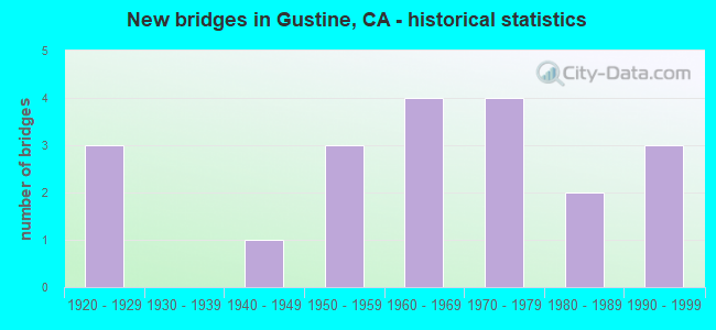
- New bridges - historical statistics
- 31920-1929
- 11940-1949
- 31950-1959
- 41960-1969
- 41970-1979
- 21980-1989
- 31990-1999

- Reconstructed bridges - Historical Statistics
- 11960-1969
- 01970-1979
- 11980-1989
- 11990-1999


- Bridge Condition - Deck
- 65.0%Good
- 5.0%Satisfactory
- 30.0%Fair

- Bridge Condition - Superstructure
- 60.0%Good
- 5.0%Satisfactory
- 30.0%Fair
- 5.0%Poor

- Bridge Condition - Substructure
- 70.0%Good
- 20.0%Satisfactory
- 10.0%Fair

- Bridge Condition - Channel
- 35.0%Very good
- 50.0%Good
- 10.0%Satisfactory
- 5.0%Fair
Find on map >> Show street view
Structure Number: 39 0046, Location: 10-MER-140-4.47 (Lat: 37.247492, Lng: -121.012714), Route carried "on" structure: State highway 140, Year Built: 1954, Status: Open, Structure Length: 3.47m (11.38ft), Average Daily Traffic: 5,650 (year 2009), Truck Traffic: 15%, Average Future Daily Traffic: 5,762 (year 2041), Design Load: HS 20, Features Intersected: CCID MAIN CANAL
Minimum Vertical Clearance: 30+ m (98+ ft), Kilometerpoint: 4.470, Lanes on structure: 2, Base Highway Network: Yes (Inventory Route: 1, Subroute: 1), Owner: State Highway Agency, Approaching Roadway Width: 14.0m (45.9ft), Skew: 5 degrees, Material/Design: Concrete continuous, Design/Construction: Slab, Number Of Spans In Main Unit: 5, Length of Maximum Span: 6.7m (22.0ft), Curb-To-Curb Width: 9.7m (31.8ft), Out-to-Out Width: 9.9m (32.5ft)
Condition: Deck: Good, Superstructure: Good, Substructure: Satisfactory, Channel: Very good, Operating Rating: 48.3 metric tons, Method Used To Determine Operating Rating: Load and Resistance Factor Rating (LRFR) rating reported by rating factor(RF) method using HL-93 loadings, Inventory Rating: 37.3 metric tons, Method Used To Determine Inventory Rating: Load and Resistance Factor Rating (LRFR) rating reported by rating factor(RF) method using HL-93 loadings, Structural Evaluation: Equal to present minimum criteria, Deck Geometry: High priority of corrective action, Waterway Adequacy: Equal to present desirable criteria, Approach Roadway Alignment: Equal to present desirable criteria, Designated Inspection Frequency: Every 24 months, Underwater Inspection Frequency: Every 60 months, Inspection Date: January 2021, Underwater Inspection Date: June 2020, Deck Structure Type: Concrete Cast-file-Place, Wearing Surface/Protective System: Wearing Surface: Bituminous
Find on map >> Show street view
Structure Number: 39 0047, Location: 10-MER-033-24.54 (Lat: 37.217831, Lng: -121.012439), Route carried "on" structure: State highway 33, Year Built: 1920, Year Reconstructed: 1973, Status: Open, Structure Length: 1.60m (5.25ft), Average Daily Traffic: 7,475 (year 2009), Truck Traffic: 23%, Average Future Daily Traffic: 11,552 (year 2039), Features Intersected: GARZAS CREEK BYPASS
Minimum Vertical Clearance: 30+ m (98+ ft), Kilometerpoint: 24.540, Lanes on structure: 2, Owner: State Highway Agency, Approaching Roadway Width: 12.2m (40.0ft), Material/Design: Concrete continuous, Design/Construction: Slab, Number Of Spans In Main Unit: 3, Length of Maximum Span: 5.1m (16.7ft), Curb-To-Curb Width: 12.2m (40.0ft), Out-to-Out Width: 12.4m (40.7ft)
Condition: Deck: Good, Superstructure: Good, Substructure: Satisfactory, Channel: Satisfactory, Operating Rating: 99.1 metric tons, Method Used To Determine Operating Rating: Load Factor (LF), Inventory Rating: 59.6 metric tons, Method Used To Determine Inventory Rating: Load Factor (LF), Structural Evaluation: Equal to present minimum criteria, Deck Geometry: Somewhat better than minimum adequacy, Waterway Adequacy: Better than present minimum criteria, Approach Roadway Alignment: Equal to present desirable criteria, Designated Inspection Frequency: Every 24 months, Inspection Date: December 2021, Deck Structure Type: Concrete Cast-file-Place, Wearing Surface/Protective System: Wearing Surface: Bituminous
Find on map >> Show street view
Structure Number: 39 0055, Location: 10-MER-140-2.30 (Lat: 37.245833, Lng: -121.047097), Route carried "on" structure: State highway 140, Year Built: 1968, Status: Open, Structure Length: 1.01m (3.31ft), Average Daily Traffic: 1,175 (year 2009), Truck Traffic: 12%, Average Future Daily Traffic: 1,362 (year 2041), Design Load: HS 20, Features Intersected: OUTSIDE CANAL
Minimum Vertical Clearance: 30+ m (98+ ft), Kilometerpoint: 2.300, Lanes on structure: 2, Base Highway Network: Yes (Inventory Route: 1, Subroute: 1), Owner: State Highway Agency, Approaching Roadway Width: 9.1m (29.9ft), Material/Design: Prestressed concrete, Design/Construction: Slab, Number Of Spans In Main Unit: 1, Length of Maximum Span: 9.8m (32.2ft), Curb-To-Curb Width: 9.8m (32.2ft), Out-to-Out Width: 10.4m (34.1ft)
Condition: Deck: Good, Superstructure: Good, Substructure: Satisfactory, Channel: Very good, Operating Rating: 46.0 metric tons, Method Used To Determine Operating Rating: Load and Resistance Factor Rating (LRFR) rating reported by rating factor(RF) method using HL-93 loadings, Inventory Rating: 26.6 metric tons, Method Used To Determine Inventory Rating: Load and Resistance Factor Rating (LRFR) rating reported by rating factor(RF) method using HL-93 loadings, Structural Evaluation: Equal to present minimum criteria, Deck Geometry: Somewhat better than minimum adequacy, Waterway Adequacy: Equal to present desirable criteria, Approach Roadway Alignment: Equal to present desirable criteria, Designated Inspection Frequency: Every 24 months, Inspection Date: January 2021, Deck Structure Type: Concrete Cast-file-Place, Wearing Surface/Protective System: Wearing Surface: Bituminous
Find on map >> Show street view
Structure Number: 39 009, Location: 10-MER-140-10.31 (Lat: 37.291267, Lng: -120.944206), Route carried "on" structure: State highway 140, Year Built: 1947, Status: Open, Structure Length: 5.55m (18.21ft), Average Daily Traffic: 3,650 (year 2009), Truck Traffic: 11%, Average Future Daily Traffic: 4,149 (year 2038), Design Load: H 20, Features Intersected: LOS BANOS CREEK
Minimum Vertical Clearance: 30+ m (98+ ft), Kilometerpoint: 10.310, Lanes on structure: 2, Base Highway Network: Yes (Inventory Route: 1, Subroute: 1), Owner: State Highway Agency, Approaching Roadway Width: 10.4m (34.1ft), Skew: 4 degrees, Material/Design: Concrete continuous, Design/Construction: Slab, Number Of Spans In Main Unit: 8, Length of Maximum Span: 6.7m (22.0ft), Curb or Sidewalk Widths: Left: 0.4m (1.3ft), Right: 0.4m (1.3ft), Curb-To-Curb Width: 7.9m (25.9ft), Out-to-Out Width: 9.3m (30.5ft)
Condition: Deck: Good, Superstructure: Good, Substructure: Good, Channel: Fair, Operating Rating: 52.5 metric tons, Method Used To Determine Operating Rating: Load Factor (LF), Inventory Rating: 31.4 metric tons, Method Used To Determine Inventory Rating: Load Factor (LF), Structural Evaluation: Better than present minimum criteria, Deck Geometry: High priority of corrective action, Waterway Adequacy: Equal to present desirable criteria, Approach Roadway Alignment: Equal to present desirable criteria, Designated Inspection Frequency: Every 24 months, Inspection Date: January 2021, Deck Structure Type: Concrete Cast-file-Place, Wearing Surface/Protective System: Wearing Surface: Bituminous
Find on map >> Show street view
Structure Number: 39 0091, Location: 10-MER-140-11.32 (Lat: 37.303825, Lng: -120.935003), Route carried "on" structure: State highway 140, Year Built: 1992, Status: Open, Structure Length: 3.44m (11.29ft), Average Daily Traffic: 3,650 (year 2009), Truck Traffic: 11%, Average Future Daily Traffic: 4,149 (year 2038), Design Load: HS 20+Mod, Features Intersected: NORTH BRANCH MUD SLOUGH
Minimum Vertical Clearance: 30+ m (98+ ft), Kilometerpoint: 11.320, Lanes on structure: 2, Base Highway Network: Yes (Inventory Route: 1, Subroute: 1), Owner: State Highway Agency, Approaching Roadway Width: 12.2m (40.0ft), Material/Design: Prestressed concrete, Design/Construction: Stringer/Multi-beam, Number Of Spans In Main Unit: 1, Length of Maximum Span: 34.4m (112.9ft), Curb-To-Curb Width: 12.2m (40.0ft), Out-to-Out Width: 13.3m (43.6ft)
Condition: Deck: Satisfactory, Superstructure: Good, Substructure: Fair, Channel: Good, Operating Rating: 54.1 metric tons, Method Used To Determine Operating Rating: Assigned rating based on Load Factor Design (LFD) reported in metric tons, Inventory Rating: 32.4 metric tons, Method Used To Determine Inventory Rating: Assigned rating based on Load Factor Design (LFD) reported in metric tons, Structural Evaluation: Somewhat better than minimum adequacy, Deck Geometry: Equal to present minimum criteria, Waterway Adequacy: Equal to present desirable criteria, Approach Roadway Alignment: Equal to present desirable criteria, Designated Inspection Frequency: Every 24 months, Inspection Date: January 2021, Deck Structure Type: Concrete Cast-file-Place
Find on map >> Show street view
Structure Number: 39 0092, Location: 10-MER-140-11.79 (Lat: 37.309650, Lng: -120.930781), Route carried "on" structure: State highway 140, Year Built: 1950, Year Reconstructed: 1993, Status: Open, Structure Length: 15.91m (52.20ft), Average Daily Traffic: 3,650 (year 2015), Truck Traffic: 11%, Average Future Daily Traffic: 4,149 (year 2040), Design Load: HS 20, Features Intersected: SAN JOAQUIN RIVER
Minimum Vertical Clearance: 30+ m (98+ ft), Kilometerpoint: 11.790, Lanes on structure: 2, Base Highway Network: Yes (Inventory Route: 1, Subroute: 1), Owner: State Highway Agency, Approaching Roadway Width: 11.9m (39.0ft), Material/Design: Concrete continuous, Design/Construction: Slab, Number Of Spans In Main Unit: 24, Length of Maximum Span: 6.7m (22.0ft), Curb-To-Curb Width: 12.2m (40.0ft), Out-to-Out Width: 13.3m (43.6ft)
Condition: Deck: Good, Superstructure: Good, Substructure: Good, Channel: Satisfactory, Operating Rating: 50.9 metric tons, Method Used To Determine Operating Rating: Load Factor (LF), Inventory Rating: 30.5 metric tons, Method Used To Determine Inventory Rating: Load Factor (LF), Structural Evaluation: Better than present minimum criteria, Deck Geometry: Equal to present minimum criteria, Waterway Adequacy: Superior to present desirable criteria, Approach Roadway Alignment: Equal to present desirable criteria, Designated Inspection Frequency: Every 24 months, Underwater Inspection Frequency: Every 60 months, Inspection Date: September 2021, Underwater Inspection Date: June 2020, Deck Structure Type: Concrete Cast-file-Place, Wearing Surface/Protective System: Wearing Surface: Bituminous
Find on map >> Show street view
Structure Number: 39 0107, Location: 10-MER-140-10.64 (Lat: 37.295356, Lng: -120.941164), Route carried "on" structure: State highway 140, Year Built: 1969, Status: Open, Structure Length: 5.30m (17.39ft), Average Daily Traffic: 3,650 (year 2009), Truck Traffic: 11%, Average Future Daily Traffic: 4,191 (year 2041), Design Load: HS 20, Features Intersected: MUD SLOUGH OVERFLOW
Minimum Vertical Clearance: 30+ m (98+ ft), Kilometerpoint: 10.640, Lanes on structure: 2, Base Highway Network: Yes (Inventory Route: 1, Subroute: 1), Owner: State Highway Agency, Approaching Roadway Width: 10.1m (33.1ft), Material/Design: Concrete continuous, Design/Construction: Slab, Number Of Spans In Main Unit: 6, Length of Maximum Span: 9.1m (29.9ft), Curb-To-Curb Width: 9.8m (32.2ft), Out-to-Out Width: 10.4m (34.1ft)
Condition: Deck: Good, Superstructure: Good, Substructure: Good, Channel: Very good, Operating Rating: 66.4 metric tons, Method Used To Determine Operating Rating: Load Factor (LF), Inventory Rating: 39.9 metric tons, Method Used To Determine Inventory Rating: Load Factor (LF), Structural Evaluation: Better than present minimum criteria, Deck Geometry: Meets minimum limits, Waterway Adequacy: Equal to present desirable criteria, Approach Roadway Alignment: Equal to present desirable criteria, Designated Inspection Frequency: Every 48 months, Underwater Inspection Frequency: Every 60 months, Inspection Date: Febuary 2019, Underwater Inspection Date: March 2021, Deck Structure Type: Concrete Cast-file-Place, Wearing Surface/Protective System: Wearing Surface: Bituminous
Find on map >> Show street view
Structure Number: 39C0084, Location: 0.1 MI S TAGLIO ROAD (Lat: 37.214600, Lng: -121.030825), Route carried "on" structure: County highway , Year Built: 1977, Status: Open, Structure Length: 0.90m (2.95ft), Average Daily Traffic: 160 (year 2015), Truck Traffic: 3%, Average Future Daily Traffic: 435 (year 2041), Design Load: HS 20+Mod, Features Intersected: GARZAS CREEK, Facility Carried by Structure: WHITWORTH ROAD
Minimum Vertical Clearance: 30+ m (98+ ft), Kilometerpoint: 0.000, Lanes on structure: 2, Owner: County Highway Agency, Approaching Roadway Width: 7.0m (23.0ft), Skew: 3 degrees, Material/Design: Concrete, Design/Construction: Slab, Number Of Spans In Main Unit: 1, Length of Maximum Span: 8.5m (27.9ft), Curb-To-Curb Width: 9.7m (31.8ft), Out-to-Out Width: 10.0m (32.8ft)
Condition: Deck: Good, Superstructure: Good, Substructure: Good, Channel: Good, Operating Rating: 99.8 metric tons, Method Used To Determine Operating Rating: Load Factor (LF), Inventory Rating: 62.9 metric tons, Method Used To Determine Inventory Rating: Load Factor (LF), Structural Evaluation: Better than present minimum criteria, Deck Geometry: Equal to present minimum criteria, Waterway Adequacy: Superior to present desirable criteria, Approach Roadway Alignment: Equal to present desirable criteria, Designated Inspection Frequency: Every 48 months, Inspection Date: Febuary 2019, Deck Structure Type: Concrete Cast-file-Place
Find on map >> Show street view
Structure Number: 39C0098, Location: 0.3 MI E OF SR 33 (Lat: 37.231178, Lng: -121.007017), Route carried "on" structure: County highway , Year Built: 1985, Status: Open, Structure Length: 2.23m (7.32ft), Average Daily Traffic: 950 (year 2015), Truck Traffic: 5%, Average Future Daily Traffic: 1,177 (year 2041), Design Load: HS 20+Mod, Features Intersected: CCID MAIN CANAL, Facility Carried by Structure: GUN CLUB RD
Minimum Vertical Clearance: 30+ m (98+ ft), Kilometerpoint: 0.000, Lanes on structure: 2, Owner: County Highway Agency, Approaching Roadway Width: 7.3m (24.0ft), Material/Design: Concrete continuous, Design/Construction: Slab, Number Of Spans In Main Unit: 3, Length of Maximum Span: 8.5m (27.9ft), Curb-To-Curb Width: 9.8m (32.2ft), Out-to-Out Width: 10.0m (32.8ft)
Condition: Deck: Good, Superstructure: Good, Substructure: Good, Channel: Very good, Operating Rating: 54.1 metric tons, Method Used To Determine Operating Rating: Assigned rating based on Load Factor Design (LFD) reported in metric tons, Inventory Rating: 32.4 metric tons, Method Used To Determine Inventory Rating: Assigned rating based on Load Factor Design (LFD) reported in metric tons, Structural Evaluation: Better than present minimum criteria, Deck Geometry: Equal to present minimum criteria, Waterway Adequacy: Superior to present desirable criteria, Approach Roadway Alignment: Equal to present desirable criteria, Length Of Structure Improvement: 2.23m (7.32ft), Designated Inspection Frequency: Every 48 months, Inspection Date: Febuary 2021, Bridge Improvement Cost: $225,000, Roadway Improvement Cost: $45,000, Total Project Cost: $378,000 ( Estimate for 2019), Deck Structure Type: Concrete Cast-file-Place
Find on map >> Show street view
Structure Number: 39C0105, Location: 0.2 MI E ORCHARD ROAD (Lat: 37.231433, Lng: -121.065503), Route carried "on" structure: County highway , Year Built: 1988, Status: Open, Structure Length: 2.23m (7.32ft), Average Daily Traffic: 20 (year 2014), Average Future Daily Traffic: 55 (year 2041), Design Load: HS 20+Mod, Features Intersected: GARZAS CREEK, Facility Carried by Structure: ROSE GARDEN ROAD
Minimum Vertical Clearance: 30+ m (98+ ft), Kilometerpoint: 0.000, Lanes on structure: 2, Owner: County Highway Agency, Approaching Roadway Width: 5.5m (18.0ft), Skew: 4 degrees, Material/Design: Concrete continuous, Design/Construction: Slab, Number Of Spans In Main Unit: 3, Length of Maximum Span: 8.5m (27.9ft), Curb-To-Curb Width: 9.8m (32.2ft), Out-to-Out Width: 9.9m (32.5ft)
Condition: Deck: Fair, Superstructure: Fair, Substructure: Good, Channel: Very good, Operating Rating: 61.6 metric tons, Method Used To Determine Operating Rating: Load Factor (LF), Inventory Rating: 37.3 metric tons, Method Used To Determine Inventory Rating: Load Factor (LF), Structural Evaluation: Somewhat better than minimum adequacy, Deck Geometry: Equal to present desirable criteria, Waterway Adequacy: Superior to present desirable criteria, Approach Roadway Alignment: Equal to present desirable criteria, Designated Inspection Frequency: Every 24 months, Inspection Date: Febuary 2021, Deck Structure Type: Concrete Cast-file-Place
Find on map >> Show street view
Structure Number: 39C0204, Location: 0.7 MI S OF S.H. 140 (Lat: 37.235453, Lng: -121.067433), Route carried "on" structure: County highway , Year Built: 1969, Status: Open, Structure Length: 1.34m (4.40ft), Average Daily Traffic: 745 (year 2014), Truck Traffic: 3%, Average Future Daily Traffic: 1,521 (year 2041), Design Load: HS 20, Features Intersected: GARZAS CREEK, Facility Carried by Structure: ORCHARD ROAD
Minimum Vertical Clearance: 30+ m (98+ ft), Kilometerpoint: 0.000, Lanes on structure: 2, Owner: County Highway Agency, Approaching Roadway Width: 7.0m (23.0ft), Skew: 4 degrees, Material/Design: Concrete continuous, Design/Construction: Slab, Number Of Spans In Main Unit: 2, Length of Maximum Span: 6.1m (20.0ft), Curb-To-Curb Width: 9.8m (32.2ft), Out-to-Out Width: 9.9m (32.5ft)
Condition: Deck: Fair, Superstructure: Fair, Substructure: Good, Channel: Good, Operating Rating: 50.9 metric tons, Method Used To Determine Operating Rating: Load Factor (LF), Inventory Rating: 30.8 metric tons, Method Used To Determine Inventory Rating: Load Factor (LF), Structural Evaluation: Somewhat better than minimum adequacy, Deck Geometry: Equal to present minimum criteria, Waterway Adequacy: Superior to present desirable criteria, Approach Roadway Alignment: Equal to present desirable criteria, Designated Inspection Frequency: Every 24 months, Inspection Date: Febuary 2021, Deck Structure Type: Concrete Cast-file-Place
Find on map >> Show street view
Structure Number: 39C0217, Location: 0.5 MI W WHITWORTH ROAD (Lat: 37.223842, Lng: -121.041344), Route carried "on" structure: County highway , Year Built: 1950, Status: Open, Structure Length: 1.28m (4.20ft), Average Daily Traffic: 103 (year 2014), Truck Traffic: 23%, Average Future Daily Traffic: 393 (year 2041), Features Intersected: OUTSIDE CANAL, Facility Carried by Structure: JORGENSEN ROAD
Minimum Vertical Clearance: 30+ m (98+ ft), Kilometerpoint: 0.000, Lanes on structure: 2, Owner: County Highway Agency, Approaching Roadway Width: 6.1m (20.0ft), Skew: 1 degrees, Material/Design: Steel, Design/Construction: Stringer/Multi-beam, Number Of Spans In Main Unit: 1, Length of Maximum Span: 11.9m (39.0ft), Curb-To-Curb Width: 7.2m (23.6ft), Out-to-Out Width: 7.4m (24.3ft)
Condition: Deck: Fair, Superstructure: Fair, Substructure: Fair, Channel: Good, Operating Rating: 63.5 metric tons, Method Used To Determine Operating Rating: Load Factor (LF), Inventory Rating: 37.9 metric tons, Method Used To Determine Inventory Rating: Load Factor (LF), Structural Evaluation: Somewhat better than minimum adequacy, Deck Geometry: Meets minimum limits, Waterway Adequacy: Superior to present desirable criteria, Approach Roadway Alignment: Equal to present desirable criteria, Designated Inspection Frequency: Every 24 months, Other Special Inspection Frequency: Every 48 months, Inspection Date: Febuary 2021, Other Special Inspection Date: Febuary 2019, Deck Structure Type: Concrete Cast-file-Place
Find on map >> Show street view
Structure Number: 39C0218, Location: 0.6 MI WEST OF WHITWORTH (Lat: 37.216764, Lng: -121.041383), Route carried "on" structure: County highway , Year Built: 1974, Status: Open, Structure Length: 2.71m (8.89ft), Average Daily Traffic: 200 (year 2014), Truck Traffic: 4%, Average Future Daily Traffic: 524 (year 2041), Design Load: HS 20, Features Intersected: OUTSIDE CNL & GARZAS CRK, Facility Carried by Structure: TAGLIO ROAD
Minimum Vertical Clearance: 30+ m (98+ ft), Kilometerpoint: 0.000, Lanes on structure: 2, Owner: County Highway Agency, Approaching Roadway Width: 5.5m (18.0ft), Skew: 5 degrees, Material/Design: Concrete continuous, Design/Construction: Slab, Number Of Spans In Main Unit: 3, Length of Maximum Span: 10.4m (34.1ft), Curb-To-Curb Width: 8.5m (27.9ft), Out-to-Out Width: 8.7m (28.5ft)
Condition: Deck: Good, Superstructure: Good, Substructure: Good, Channel: Good, Operating Rating: 79.7 metric tons, Method Used To Determine Operating Rating: Load Factor (LF), Inventory Rating: 48.0 metric tons, Method Used To Determine Inventory Rating: Load Factor (LF), Structural Evaluation: Better than present minimum criteria, Deck Geometry: Equal to present minimum criteria, Waterway Adequacy: Superior to present desirable criteria, Approach Roadway Alignment: Equal to present desirable criteria, Designated Inspection Frequency: Every 48 months, Inspection Date: Febuary 2019, Deck Structure Type: Concrete Cast-file-Place
Find on map >> Show street view
Structure Number: 39C0219, Location: 0.1 MI EAST OF SR 33 (Lat: 37.209408, Lng: -121.011728), Route carried "on" structure: County highway , Year Built: 1926, Status: Open, Structure Length: 1.74m (5.71ft), Average Daily Traffic: 102 (year 2014), Truck Traffic: 15%, Average Future Daily Traffic: 393 (year 2041), Features Intersected: CCID MAIN CANAL, Facility Carried by Structure: PFITZER ROAD
Minimum Vertical Clearance: 30+ m (98+ ft), Kilometerpoint: 0.000, Lanes on structure: 2, Owner: County Highway Agency, Approaching Roadway Width: 6.7m (22.0ft), Material/Design: Concrete continuous, Design/Construction: Slab, Number Of Spans In Main Unit: 3, Length of Maximum Span: 5.8m (19.0ft), Curb-To-Curb Width: 6.7m (22.0ft), Out-to-Out Width: 7.2m (23.6ft)
Condition: Deck: Fair, Superstructure: Fair, Substructure: Good, Channel: Good, Operating Rating: 33.7 metric tons, Method Used To Determine Operating Rating: Load Factor (LF), Inventory Rating: 20.1 metric tons, Method Used To Determine Inventory Rating: Load Factor (LF), Structural Evaluation: Somewhat better than minimum adequacy, Deck Geometry: Meets minimum limits, Waterway Adequacy: Better than present minimum criteria, Approach Roadway Alignment: Equal to present desirable criteria, Length Of Structure Improvement: 1.74m (5.71ft), Designated Inspection Frequency: Every 24 months, Inspection Date: Febuary 2021, Bridge Improvement Cost: $285,000, Roadway Improvement Cost: $57,000, Total Project Cost: $479,000 ( Estimate for 2017), Deck Structure Type: Concrete Cast-file-Place
Find on map >> Show street view
Structure Number: 39C0221, Location: 0.5 MI W SANTA FE GRADE (Lat: 37.231900, Lng: -120.942283), Route carried "on" structure: County highway , Year Built: 1965, Status: Open, Structure Length: 1.01m (3.31ft), Average Daily Traffic: 123 (year 2014), Truck Traffic: 29%, Average Future Daily Traffic: 326 (year 2041), Design Load: HS 20, Features Intersected: LOS BANOS CREEK, Facility Carried by Structure: GUN CLUB ROAD
Minimum Vertical Clearance: 30+ m (98+ ft), Kilometerpoint: 0.000, Lanes on structure: 2, Owner: County Highway Agency, Approaching Roadway Width: 7.3m (24.0ft), Material/Design: Steel, Design/Construction: Stringer/Multi-beam, Number Of Spans In Main Unit: 1, Length of Maximum Span: 9.1m (29.9ft), Curb-To-Curb Width: 9.8m (32.2ft), Out-to-Out Width: 9.9m (32.5ft)
Condition: Deck: Good, Superstructure: Fair, Substructure: Good, Channel: Good, Operating Rating: 36.0 metric tons, Method Used To Determine Operating Rating: Load Factor (LF), Inventory Rating: 21.4 metric tons, Method Used To Determine Inventory Rating: Load Factor (LF), Structural Evaluation: Somewhat better than minimum adequacy, Deck Geometry: Better than present minimum criteria, Waterway Adequacy: Equal to present minimum criteria, Approach Roadway Alignment: Equal to present desirable criteria, Designated Inspection Frequency: Every 24 months, Other Special Inspection Frequency: Every 48 months, Inspection Date: Febuary 2021, Other Special Inspection Date: April 2019, Deck Structure Type: Concrete Cast-file-Place, Wearing Surface/Protective System: Wearing Surface: Bituminous
Find on map >> Show street view
Structure Number: 39C0222, Location: 0.4 MI E WHITWORTH RD (Lat: 37.260075, Lng: -121.021097), Route carried "on" structure: County highway , Year Built: 1925, Status: Open, Structure Length: 2.26m (7.41ft), Average Daily Traffic: 120 (year 2014), Truck Traffic: 2%, Average Future Daily Traffic: 314 (year 2041), Features Intersected: CCID MAIN CANAL, Facility Carried by Structure: FENTEM ROAD
Minimum Vertical Clearance: 30+ m (98+ ft), Kilometerpoint: 0.000, Lanes on structure: 2, Owner: County Highway Agency, Approaching Roadway Width: 6.4m (21.0ft), Skew: 4 degrees, Material/Design: Concrete continuous, Design/Construction: Slab, Number Of Spans In Main Unit: 4, Length of Maximum Span: 5.8m (19.0ft), Curb-To-Curb Width: 6.4m (21.0ft), Out-to-Out Width: 7.3m (24.0ft)
Condition: Deck: Good, Superstructure: Good, Substructure: Good, Channel: Very good, Operating Rating: 38.2 metric tons, Method Used To Determine Operating Rating: Load Factor (LF), Inventory Rating: 23.0 metric tons, Method Used To Determine Inventory Rating: Load Factor (LF), Structural Evaluation: Equal to present minimum criteria, Deck Geometry: Meets minimum limits, Waterway Adequacy: Superior to present desirable criteria, Approach Roadway Alignment: Equal to present desirable criteria, Designated Inspection Frequency: Every 24 months, Underwater Inspection Frequency: Every 60 months, Inspection Date: Febuary 2021, Underwater Inspection Date: June 2020, Deck Structure Type: Concrete Cast-file-Place, Wearing Surface/Protective System: Wearing Surface: Bituminous
Find on map >> Show street view
Structure Number: 39C0223, Location: 0.1 MI N WORTHINGTON RD (Lat: 37.270428, Lng: -121.030928), Route carried "on" structure: County highway , Year Built: 1972, Status: Open, Structure Length: 2.07m (6.79ft), Average Daily Traffic: 160 (year 2014), Truck Traffic: 3%, Average Future Daily Traffic: 448 (year 2041), Design Load: HS 20, Features Intersected: CCID MAIN CANAL, Facility Carried by Structure: WHITWORTH ROAD
Minimum Vertical Clearance: 30+ m (98+ ft), Kilometerpoint: 0.000, Lanes on structure: 2, Owner: County Highway Agency, Approaching Roadway Width: 7.6m (24.9ft), Skew: 4 degrees, Material/Design: Concrete continuous, Design/Construction: Slab, Number Of Spans In Main Unit: 2, Length of Maximum Span: 9.8m (32.2ft), Curb-To-Curb Width: 9.8m (32.2ft), Out-to-Out Width: 9.9m (32.5ft)
Condition: Deck: Good, Superstructure: Good, Substructure: Good, Channel: Good, Operating Rating: 83.9 metric tons, Method Used To Determine Operating Rating: Load Factor (LF), Inventory Rating: 50.2 metric tons, Method Used To Determine Inventory Rating: Load Factor (LF), Structural Evaluation: Better than present minimum criteria, Deck Geometry: Better than present minimum criteria, Waterway Adequacy: Superior to present desirable criteria, Approach Roadway Alignment: Equal to present desirable criteria, Designated Inspection Frequency: Every 48 months, Inspection Date: Febuary 2019, Deck Structure Type: Concrete Cast-file-Place, Wearing Surface/Protective System: Wearing Surface: Bituminous
Find on map >> Show street view
Structure Number: 39C0358, Location: 1.2 MI N GUN CLUB ROAD (Lat: 37.245333, Lng: -120.943383), Route carried "on" structure: County highway , Year Built: 1974, Status: Open, Structure Length: 1.05m (3.44ft), Average Daily Traffic: 186 (year 2014), Truck Traffic: 1%, Average Future Daily Traffic: 326 (year 2041), Design Load: HS 20, Features Intersected: LOS BANOS CREEK, Facility Carried by Structure: SANTA FE GRADE
Minimum Vertical Clearance: 30+ m (98+ ft), Kilometerpoint: 0.000, Lanes on structure: 2, Owner: County Highway Agency, Approaching Roadway Width: 7.5m (24.6ft), Material/Design: Concrete continuous, Design/Construction: Slab, Number Of Spans In Main Unit: 2, Length of Maximum Span: 4.9m (16.1ft), Curb-To-Curb Width: 7.3m (24.0ft), Out-to-Out Width: 7.5m (24.6ft)
Condition: Deck: Fair, Superstructure: Poor, Substructure: Good, Channel: Good, Operating Rating: 62.9 metric tons, Method Used To Determine Operating Rating: Load Factor (LF), Inventory Rating: 37.6 metric tons, Method Used To Determine Inventory Rating: Load Factor (LF), Structural Evaluation: Meets minimum limits, Deck Geometry: Somewhat better than minimum adequacy, Waterway Adequacy: Equal to present desirable criteria, Approach Roadway Alignment: Equal to present desirable criteria, Length Of Structure Improvement: 1.07m (3.51ft), Designated Inspection Frequency: Every 24 months, Inspection Date: Febuary 2021, Bridge Improvement Cost: $167,000, Roadway Improvement Cost: $33,000, Total Project Cost: $282,000 ( Estimate for 2017), Deck Structure Type: Concrete Cast-file-Place
Find on map >> Show street view
Structure Number: 39C0361, Location: 50 FT E OF SR140 & SR33 (Lat: 37.245775, Lng: -121.012478), Route carried "on" structure: City street , Year Built: 1996, Status: Open, Structure Length: 2.29m (7.51ft), Average Daily Traffic: 1,101 (year 2011), Truck Traffic: 6%, Average Future Daily Traffic: 1,544 (year 2038), Design Load: HS 20+Mod, Features Intersected: CCID MAIN CANAL, Facility Carried by Structure: SULLIVAN ROAD
Minimum Vertical Clearance: 30+ m (98+ ft), Kilometerpoint: 0.000, Lanes on structure: 3, Owner: City or Municipal Highway Agency, Approaching Roadway Width: 14.9m (48.9ft), Material/Design: Concrete continuous, Design/Construction: Slab, Number Of Spans In Main Unit: 3, Length of Maximum Span: 8.8m (28.9ft), Curb or Sidewalk Widths: Left: 1.5m (4.9ft), Right: 0.0m, Curb-To-Curb Width: 13.4m (44.0ft), Out-to-Out Width: 15.8m (51.8ft)
Condition: Deck: Fair, Superstructure: Fair, Substructure: Good, Channel: Very good, Operating Rating: 54.1 metric tons, Method Used To Determine Operating Rating: Assigned rating based on Load Factor Design (LFD) reported in metric tons, Inventory Rating: 32.4 metric tons, Method Used To Determine Inventory Rating: Assigned rating based on Load Factor Design (LFD) reported in metric tons, Structural Evaluation: Somewhat better than minimum adequacy, Deck Geometry: Somewhat better than minimum adequacy, Waterway Adequacy: Superior to present desirable criteria, Approach Roadway Alignment: Equal to present desirable criteria, Designated Inspection Frequency: Every 24 months, Underwater Inspection Frequency: Every 60 months, Inspection Date: Febuary 2021, Underwater Inspection Date: June 2020, Deck Structure Type: Concrete Cast-file-Place
Find on map >> Show street view
Structure Number: 11651-00163, Location: REFUGE ACCESS RD/PRK.LOT3 (Lat: 37.263667, Lng: -120.906167), Route carried "on" structure: Federal lands road , Year Built: 1990, Year Reconstructed: 2001, Status: Open, Structure Length: 2.59m (8.50ft), Average Daily Traffic: 10 (year 2020), Average Future Daily Traffic: 15 (year 2040), Features Intersected: MUD SLOUGH, Facility Carried by Structure: CENTER ACCESS ROAD
Minimum Vertical Clearance: 30.48m (100.00ft), Kilometerpoint: 4.023, Lanes on structure: 2, Owner: Bureau of Fish and Wildlife, Approaching Roadway Width: 7.3m (24.0ft), Material/Design: Steel, Design/Construction: Girder and Floorbeam System, Number Of Spans In Main Unit: 1, Length of Maximum Span: 23.8m (78.1ft), Curb-To-Curb Width: 7.7m (25.3ft), Out-to-Out Width: 7.9m (25.9ft)
Condition: Deck: Good, Superstructure: Satisfactory, Substructure: Satisfactory, Channel: Good, Operating Rating: 27.2 metric tons, Method Used To Determine Operating Rating: Allowable Stress (AS), Inventory Rating: 16.3 metric tons, Method Used To Determine Inventory Rating: Allowable Stress (AS), Structural Evaluation: Somewhat better than minimum adequacy, Deck Geometry: Equal to present minimum criteria, Waterway Adequacy: Better than present minimum criteria, Approach Roadway Alignment: Somewhat better than minimum adequacy, Designated Inspection Frequency: Every 24 months, Inspection Date: October 2020, Deck Structure Type: Steel plate, Wearing Surface/Protective System: Wearing Surface: Bituminous