Bridge Statistics for Hackberry, Louisiana (LA)
Condition, Traffic, Stress, Structural Evaluation, Project Costs
- National Bridge Inventory (NBI) Statistics
- 14Number of bridges
- 138ft / 42.1mTotal length
- $1,152,000Total costs
- 17,037Total average daily traffic
- 2,886Total average daily truck traffic
- 14,014Total future (year 2036) average daily traffic
- National Bridge Inventory (NBI) Registered Bridges for Hackberry
- No street view available for this location
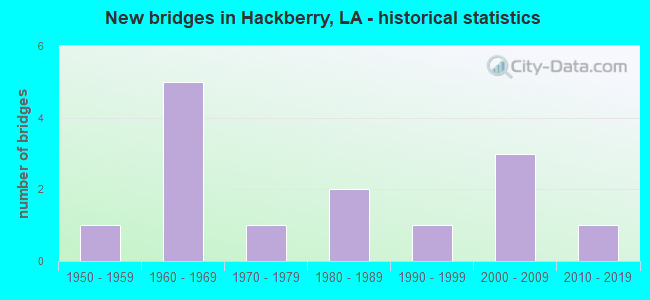
- New bridges - historical statistics
- 11950-1959
- 51960-1969
- 11970-1979
- 21980-1989
- 11990-1999
- 32000-2009
- 12010-2019


- Bridge Condition - Deck
- 7.7%Very good
- 15.4%Good
- 23.1%Satisfactory
- 38.5%Fair
- 15.4%Poor

- Bridge Condition - Superstructure
- 7.7%Very good
- 7.7%Good
- 23.1%Satisfactory
- 53.8%Fair
- 7.7%Poor

- Bridge Condition - Substructure
- 7.7%Very good
- 23.1%Good
- 23.1%Satisfactory
- 38.5%Fair
- 7.7%Poor

- Bridge Condition - Channel
- 14.3%Very good
- 64.3%Good
- 14.3%Satisfactory
- 7.1%Fair
Find on map >> Show street view
Structure Number: 43640-00109, Location: POOLS 1A/1B (Lat: 29.878833, Lng: -93.425500), Route carried "on" structure: Federal lands road , Year Built: 1985, Status: Open, Structure Length: 2.16m (7.09ft), Average Daily Traffic: 58 (year 2020), Average Future Daily Traffic: 80 (year 2041), Design Load: HS 20, Features Intersected: ROADSIDE CANAL, Facility Carried by Structure: OFF HIGHWAY 27
Minimum Vertical Clearance: 30.48m (100.00ft), Kilometerpoint: 0.032, Lanes on structure: 2, Owner: Bureau of Fish and Wildlife, Approaching Roadway Width: 7.3m (24.0ft), Material/Design: Concrete, Design/Construction: Slab, Number Of Spans In Main Unit: 3, Length of Maximum Span: 7.0m (23.0ft), Curb-To-Curb Width: 7.2m (23.6ft), Out-to-Out Width: 7.3m (24.0ft)
Condition: Deck: Satisfactory, Superstructure: Satisfactory, Substructure: Good, Channel: Good, Operating Rating: 37.2 metric tons, Method Used To Determine Operating Rating: Allowable Stress (AS), Inventory Rating: 20.9 metric tons, Method Used To Determine Inventory Rating: Allowable Stress (AS), Structural Evaluation: Equal to present minimum criteria, Deck Geometry: Somewhat better than minimum adequacy, Waterway Adequacy: Better than present minimum criteria, Approach Roadway Alignment: Equal to present minimum criteria, Designated Inspection Frequency: Every 24 months, Inspection Date: April 2021, Deck Structure Type: Concrete Cast-file-Place, Wearing Surface/Protective System: Wearing Surface: Monolithic Concrete
Find on map >> Show street view
Structure Number: 43640-00132, Location: CANAL ALONG LA HWY. 27 (Lat: 29.921000, Lng: -93.380333), Route carried "on" structure: Federal lands road , Year Built: 2012, Status: Open, Structure Length: 2.13m (6.99ft), Average Daily Traffic: 65 (year 2021), Average Future Daily Traffic: 80 (year 2041), Design Load: HL 93, Features Intersected: ROADSIDE CANAL, Facility Carried by Structure: UNNAMED
Minimum Vertical Clearance: 30.48m (100.00ft), Kilometerpoint: 0.032, Lanes on structure: 2, Owner: Bureau of Fish and Wildlife, Approaching Roadway Width: 7.3m (24.0ft), Material/Design: Concrete, Design/Construction: Slab, Number Of Spans In Main Unit: 3, Length of Maximum Span: 7.0m (23.0ft), Curb-To-Curb Width: 7.2m (23.6ft), Out-to-Out Width: 7.3m (24.0ft)
Condition: Deck: Very good, Superstructure: Very good, Substructure: Very good, Channel: Very good, Operating Rating: 70.8 metric tons, Method Used To Determine Operating Rating: Load Factor (LF), Inventory Rating: 42.6 metric tons, Method Used To Determine Inventory Rating: Load Factor (LF), Structural Evaluation: Equal to present desirable criteria, Deck Geometry: Somewhat better than minimum adequacy, Waterway Adequacy: Equal to present desirable criteria, Approach Roadway Alignment: Better than present minimum criteria, Designated Inspection Frequency: Every 24 months, Inspection Date: April 2021, Deck Structure Type: Other, Wearing Surface/Protective System: Wearing Surface: Monolithic Concrete
Find on map >> Show street view
Structure Number: 43640-00134, Location: VASTAR ROAD (Lat: 29.878000, Lng: -93.470667), Route carried "on" structure: Federal lands road , Year Built: 1983, Status: Posted for load, Structure Length: 2.07m (6.79ft), Average Daily Traffic: 10 (year 2021), Average Future Daily Traffic: 15 (year 2041), Features Intersected: CENTRAL CANAL, Facility Carried by Structure: VASTAR ROAD
Minimum Vertical Clearance: 30.48m (100.00ft), Kilometerpoint: 2.092, Lanes on structure: 2, Owner: Bureau of Fish and Wildlife, Approaching Roadway Width: 4.0m (13.1ft), Material/Design: Wood or Timber, Design/Construction: Stringer/Multi-beam, Number Of Spans In Main Unit: 6, Length of Maximum Span: 6.7m (22.0ft), Curb or Sidewalk Widths: Left: 0.6m (2.0ft), Right: 0.2m (0.7ft), Curb-To-Curb Width: 5.9m (19.4ft), Out-to-Out Width: 6.1m (20.0ft)
Condition: Deck: Good, Superstructure: Poor, Substructure: Good, Channel: Fair, Operating Rating: 13.6 metric tons, Method Used To Determine Operating Rating: Load Factor (LF), Inventory Rating: 9.1 metric tons, Method Used To Determine Inventory Rating: Load Factor (LF), Structural Evaluation: High priority of replacement, Deck Geometry: Meets minimum limits, Waterway Adequacy: Better than present minimum criteria, Approach Roadway Alignment: Somewhat better than minimum adequacy, Bridge Posting: Required (Relationship of Operating Rating to Maximum Legal Load: > 39.9% below), Length Of Structure Improvement: 2.80m (9.19ft), Designated Inspection Frequency: Every 24 months, Inspection Date: April 2021, Bridge Improvement Cost: $217,000, Roadway Improvement Cost: $22,000, Total Project Cost: $544,000 ( Estimate for 2020), Deck Structure Type: Wood or Timber, Wearing Surface/Protective System: Wearing Surface: Wood or Timber
Find on map >> Show street view
Structure Number: 71200310209821, Location: 9.8 MI. N OF INT LA82 (Lat: 29.883531, Lng: -93.416400), Route carried "on" structure: State highway 27, Year Built: 1999, Status: Open, Structure Length: 3.05m (10.01ft), Average Daily Traffic: 1,560 (year 2016), Truck Traffic: 17%, Average Future Daily Traffic: 978 (year 2036), Design Load: HS 20, Features Intersected: LITTLE CROSS CREEK
Minimum Vertical Clearance: 30+ m (98+ ft), Kilometerpoint: 15.501, Lanes on structure: 2, Owner: State Highway Agency, Approaching Roadway Width: 7.3m (24.0ft), Material/Design: Concrete, Design/Construction: Slab, Number Of Spans In Main Unit: 4, Length of Maximum Span: 7.6m (24.9ft), Curb-To-Curb Width: 12.2m (40.0ft), Out-to-Out Width: 13.0m (42.7ft)
Condition: Deck: Good, Superstructure: Good, Substructure: Satisfactory, Channel: Good, Operating Rating: 70.7 metric tons, Method Used To Determine Operating Rating: Load Factor (LF), Inventory Rating: 41.7 metric tons, Method Used To Determine Inventory Rating: Load Factor (LF), Structural Evaluation: Equal to present minimum criteria, Deck Geometry: Better than present minimum criteria, Waterway Adequacy: Equal to present desirable criteria, Approach Roadway Alignment: Equal to present desirable criteria, Designated Inspection Frequency: Every 24 months, Inspection Date: September 2021, Deck Structure Type: Concrete Cast-file-Place
Find on map >> Show street view
Structure Number: 71200310212781, Location: 12.78 MI. N OF INT LA82 (Lat: 29.909531, Lng: -93.383700), Route carried "on" structure: State highway 27, Year Built: 2000, Status: Open, Structure Length: 6.86m (22.51ft), Average Daily Traffic: 1,560 (year 2016), Truck Traffic: 17%, Average Future Daily Traffic: 978 (year 2036), Design Load: HS 20, Features Intersected: HOG ISLAND GULLY
Minimum Vertical Clearance: 30+ m (98+ ft), Kilometerpoint: 20.210, Lanes on structure: 2, Owner: State Highway Agency, Approaching Roadway Width: 7.3m (24.0ft), Material/Design: Concrete, Design/Construction: Slab, Number Of Spans In Main Unit: 9, Length of Maximum Span: 7.6m (24.9ft), Curb-To-Curb Width: 12.2m (40.0ft), Out-to-Out Width: 13.0m (42.7ft)
Condition: Deck: Fair, Superstructure: Fair, Substructure: Fair, Channel: Very good, Operating Rating: 70.7 metric tons, Method Used To Determine Operating Rating: Load Factor (LF), Inventory Rating: 41.7 metric tons, Method Used To Determine Inventory Rating: Load Factor (LF), Structural Evaluation: Somewhat better than minimum adequacy, Deck Geometry: Better than present minimum criteria, Waterway Adequacy: Equal to present desirable criteria, Approach Roadway Alignment: Equal to present desirable criteria, Designated Inspection Frequency: Every 24 months, Inspection Date: Febuary 2022, Deck Structure Type: Concrete Cast-file-Place
Find on map >> Show street view
Structure Number: 71200310214241, Location: 14.24 MI. N OF INT LA82 (Lat: 29.929900, Lng: -93.377331), Route carried "on" structure: State highway 27, Year Built: 2000, Status: Open, Structure Length: 3.05m (10.01ft), Average Daily Traffic: 2,800 (year 2016), Truck Traffic: 17%, Average Future Daily Traffic: 1,440 (year 2036), Design Load: HS 20, Features Intersected: LONG POINT BAYOU
Minimum Vertical Clearance: 30+ m (98+ ft), Kilometerpoint: 23.305, Lanes on structure: 2, Owner: State Highway Agency, Approaching Roadway Width: 7.3m (24.0ft), Material/Design: Concrete, Design/Construction: Slab, Number Of Spans In Main Unit: 4, Length of Maximum Span: 7.6m (24.9ft), Curb-To-Curb Width: 12.2m (40.0ft), Out-to-Out Width: 13.0m (42.7ft)
Condition: Deck: Fair, Superstructure: Fair, Substructure: Satisfactory, Channel: Good, Operating Rating: 70.7 metric tons, Method Used To Determine Operating Rating: Load Factor (LF), Inventory Rating: 41.7 metric tons, Method Used To Determine Inventory Rating: Load Factor (LF), Structural Evaluation: Somewhat better than minimum adequacy, Deck Geometry: Equal to present minimum criteria, Waterway Adequacy: Equal to present desirable criteria, Approach Roadway Alignment: Equal to present desirable criteria, Designated Inspection Frequency: Every 24 months, Inspection Date: Febuary 2022, Deck Structure Type: Concrete Cast-file-Place
Find on map >> Show street view
Structure Number: 71200310214721, Location: 14.72 MI. N OF INT LA82 (Lat: 29.936500, Lng: -93.375281), Route carried "on" structure: State highway 27, Year Built: 2000, Status: Open, Structure Length: 3.05m (10.01ft), Average Daily Traffic: 2,800 (year 2016), Truck Traffic: 17%, Average Future Daily Traffic: 1,440 (year 2036), Design Load: HS 20, Features Intersected: KAYOU BAYOU
Minimum Vertical Clearance: 30+ m (98+ ft), Kilometerpoint: 23.305, Lanes on structure: 2, Owner: State Highway Agency, Approaching Roadway Width: 7.3m (24.0ft), Material/Design: Concrete, Design/Construction: Slab, Number Of Spans In Main Unit: 4, Length of Maximum Span: 7.6m (24.9ft), Curb-To-Curb Width: 12.2m (40.0ft), Out-to-Out Width: 13.0m (42.7ft)
Condition: Deck: Satisfactory, Superstructure: Satisfactory, Substructure: Satisfactory, Channel: Good, Operating Rating: 69.8 metric tons, Method Used To Determine Operating Rating: Load Factor (LF), Inventory Rating: 41.7 metric tons, Method Used To Determine Inventory Rating: Load Factor (LF), Structural Evaluation: Equal to present minimum criteria, Deck Geometry: Equal to present minimum criteria, Waterway Adequacy: Equal to present desirable criteria, Approach Roadway Alignment: Equal to present desirable criteria, Designated Inspection Frequency: Every 24 months, Inspection Date: January 2022, Deck Structure Type: Other
Find on map >> Show street view
Structure Number: 71200310303551, Location: 10 MI S of LA 108 (Lat: 30.004119, Lng: -93.343500), Route carried "on" structure: State highway 27, Year Built: 1977, Status: Posted for load, Structure Length: 12.37m (40.58ft), Average Daily Traffic: 3,900 (year 2016), Truck Traffic: 18%, Average Future Daily Traffic: 4,290 (year 2036), Design Load: HS 20, Features Intersected: KELSO BAYOU/HACKBERRY
Minimum Vertical Clearance: 5.51m (18.08ft), Kilometerpoint: 5.597, Lanes on structure: 2, Base Highway Network: Yes (Inventory Route: 31-03-1, Subroute: 10), Owner: State Highway Agency, Approaching Roadway Width: 13.4m (44.0ft), Navigation Control: Yes ( Vertical Clearance: 1.8m (5.9ft), Horizontal Clearance: 15.2m (49.9ft)), Material/Design: Steel, Design/Construction: Movable - Swing, Number Of Spans In Main Unit: 14, Length of Maximum Span: 41.1m (134.8ft), Curb-To-Curb Width: 12.2m (40.0ft), Out-to-Out Width: 14.3m (46.9ft)
Condition: Deck: Poor, Superstructure: Fair, Substructure: Good, Channel: Good, Operating Rating: 28.5 metric tons, Method Used To Determine Operating Rating: Load and Resistance Factor Rating (LRFR) rating reported by rating factor(RF) method using HL-93 loadings, Inventory Rating: 22.0 metric tons, Method Used To Determine Inventory Rating: Load and Resistance Factor Rating (LRFR) rating reported by rating factor(RF) method using HL-93 loadings, Structural Evaluation: Somewhat better than minimum adequacy, Deck Geometry: Equal to present minimum criteria, Waterway Adequacy: Better than present minimum criteria, Approach Roadway Alignment: Equal to present desirable criteria, Bridge Posting: Required (Relationship of Operating Rating to Maximum Legal Load: 0.1 - 9.9% below), Designated Inspection Frequency: Every 24 months, Critical Feature Inspection Frequency: Every 24 months, Underwater Inspection Frequency: Every 60 months, Other Special Inspection Frequency: Every 12 months, Inspection Date: January 2021, Critical Feature Inspection Date: January 2021, Underwater Inspection Date: August 2021, Other Special Inspection Date: January 2022, Deck Structure Type: Concrete Cast-file-Place
Find on map >> Show street view
Structure Number: 71200310305701, Location: 07120310305701 (Lat: 30.034819, Lng: -93.339419), Route carried "on" structure: State highway 27, Year Built: 1957, Year Reconstructed: 2018, Status: Open, Structure Length: 1.55m (5.09ft), Average Daily Traffic: 3,900 (year 2016), Truck Traffic: 18%, Average Future Daily Traffic: 4,290 (year 2036), Design Load: HS 20, Features Intersected: CRAB GULLY
Minimum Vertical Clearance: 30+ m (98+ ft), Kilometerpoint: 9.173, Lanes on structure: 2, Base Highway Network: Yes (Inventory Route: 31-03-1, Subroute: 10), Owner: State Highway Agency, Approaching Roadway Width: 10.4m (34.1ft), Material/Design: Concrete, Design/Construction: Culvert, Number Of Spans In Main Unit: 9, Length of Maximum Span: 1.5m (4.9ft), Curb-To-Curb Width: 15.5m (50.9ft), Out-to-Out Width: 19.2m (63.0ft)
Condition: Channel: Good, Culverts: Poor, Operating Rating: 48.6 metric tons, Method Used To Determine Operating Rating: Load and Resistance Factor Rating (LRFR) rating reported by rating factor(RF) method using HL-93 loadings, Inventory Rating: 37.6 metric tons, Method Used To Determine Inventory Rating: Load and Resistance Factor Rating (LRFR) rating reported by rating factor(RF) method using HL-93 loadings, Structural Evaluation: Meets minimum limits, Deck Geometry: Superior to present desirable criteria, Waterway Adequacy: Equal to present desirable criteria, Approach Roadway Alignment: Equal to present desirable criteria, Length Of Structure Improvement: 2.26m (7.41ft), Designated Inspection Frequency: Every 24 months, Other Special Inspection Frequency: Every 12 months, Inspection Date: Febuary 2021, Other Special Inspection Date: Febuary 2022, Bridge Improvement Cost: $192,000, Total Project Cost: $288,000 ( Estimate for 2016), Deck Structure Type: Concrete Cast-file-Place
Find on map >> Show street view
Structure Number: 71229582932261, Location: NO. 664 0.65 MI. S (Lat: 29.969819, Lng: -93.375619), Route carried "on" structure: County highway , Year Built: 1964, Status: Posted for load, Structure Length: 1.16m (3.81ft), Average Daily Traffic: 27 (year 2020), Average Future Daily Traffic: 30 (year 2040), Design Load: HS 20, Features Intersected: LULU CANAL, Facility Carried by Structure: S. ALLADIN RD.
Minimum Vertical Clearance: 30+ m (98+ ft), Kilometerpoint: 0.000, Lanes on structure: 2, Owner: County Highway Agency, Approaching Roadway Width: 7.3m (24.0ft), Material/Design: Concrete, Design/Construction: Slab, Number Of Spans In Main Unit: 2, Length of Maximum Span: 5.8m (19.0ft), Curb-To-Curb Width: 7.4m (24.3ft), Out-to-Out Width: 8.4m (27.6ft)
Condition: Deck: Fair, Superstructure: Fair, Substructure: Fair, Channel: Good, Operating Rating: 17.2 metric tons, Method Used To Determine Operating Rating: Load and Resistance Factor Rating (LRFR) rating reported by rating factor(RF) method using HL-93 loadings, Inventory Rating: 13.3 metric tons, Method Used To Determine Inventory Rating: Load and Resistance Factor Rating (LRFR) rating reported by rating factor(RF) method using HL-93 loadings, Structural Evaluation: Meets minimum limits, Deck Geometry: Equal to present minimum criteria, Waterway Adequacy: Equal to present desirable criteria, Approach Roadway Alignment: Equal to present desirable criteria, Bridge Posting: Required (Relationship of Operating Rating to Maximum Legal Load: 30.0 - 39.9% below), Designated Inspection Frequency: Every 24 months, Other Special Inspection Frequency: Every 12 months, Inspection Date: March 2020, Other Special Inspection Date: March 2021, Deck Structure Type: Concrete Precast Panels, Wearing Surface/Protective System: Wearing Surface: Bituminous
Find on map >> Show street view
Structure Number: 71229583932221, Location: 0.05 MI. W. OF INT. (Lat: 29.972000, Lng: -93.368161), Route carried "on" structure: County highway , Year Built: 1964, Status: Posted for load, Structure Length: 1.16m (3.81ft), Average Daily Traffic: 27 (year 2020), Average Future Daily Traffic: 30 (year 2040), Design Load: HS 20, Features Intersected: LULU CANAL, Facility Carried by Structure: N. ALLADIN RD.
Minimum Vertical Clearance: 30+ m (98+ ft), Kilometerpoint: 0.000, Lanes on structure: 2, Owner: County Highway Agency, Approaching Roadway Width: 7.3m (24.0ft), Material/Design: Concrete, Design/Construction: Slab, Number Of Spans In Main Unit: 2, Length of Maximum Span: 5.8m (19.0ft), Curb-To-Curb Width: 7.4m (24.3ft), Out-to-Out Width: 8.6m (28.2ft)
Condition: Deck: Fair, Superstructure: Fair, Substructure: Fair, Channel: Satisfactory, Operating Rating: 42.6 metric tons, Method Used To Determine Operating Rating: Allowable Stress (AS), Inventory Rating: 25.4 metric tons, Method Used To Determine Inventory Rating: Allowable Stress (AS), Structural Evaluation: Somewhat better than minimum adequacy, Deck Geometry: Equal to present minimum criteria, Waterway Adequacy: Equal to present minimum criteria, Approach Roadway Alignment: Equal to present desirable criteria, Bridge Posting: Required (Relationship of Operating Rating to Maximum Legal Load: > 39.9% below), Designated Inspection Frequency: Every 24 months, Other Special Inspection Frequency: Every 12 months, Inspection Date: March 2020, Other Special Inspection Date: March 2021, Deck Structure Type: Concrete Precast Panels, Wearing Surface/Protective System: Wearing Surface: Bituminous
Find on map >> Show street view
Structure Number: 71229585932191, Location: 0.08 MI. E. OF INT. (Lat: 29.974539, Lng: -93.365869), Route carried "on" structure: County highway , Year Built: 1964, Status: Posted for load, Structure Length: 1.16m (3.81ft), Average Daily Traffic: 8 (year 2020), Average Future Daily Traffic: 9 (year 2040), Design Load: HS 20, Features Intersected: LULU CANAL, Facility Carried by Structure: LEONARD LITTLE RD.
Minimum Vertical Clearance: 30+ m (98+ ft), Kilometerpoint: 0.000, Lanes on structure: 2, Owner: County Highway Agency, Approaching Roadway Width: 7.3m (24.0ft), Material/Design: Concrete, Design/Construction: Slab, Number Of Spans In Main Unit: 2, Length of Maximum Span: 5.8m (19.0ft), Curb-To-Curb Width: 7.4m (24.3ft), Out-to-Out Width: 8.2m (26.9ft)
Condition: Deck: Poor, Superstructure: Fair, Substructure: Fair, Channel: Satisfactory, Operating Rating: 45.4 metric tons, Method Used To Determine Operating Rating: Allowable Stress (AS), Inventory Rating: 27.2 metric tons, Method Used To Determine Inventory Rating: Allowable Stress (AS), Structural Evaluation: Somewhat better than minimum adequacy, Deck Geometry: Equal to present minimum criteria, Waterway Adequacy: Better than present minimum criteria, Approach Roadway Alignment: Equal to present minimum criteria, Bridge Posting: Required (Relationship of Operating Rating to Maximum Legal Load: > 39.9% below), Length Of Structure Improvement: 1.80m (5.91ft), Designated Inspection Frequency: Every 24 months, Other Special Inspection Frequency: Every 12 months, Inspection Date: March 2020, Other Special Inspection Date: March 2021, Bridge Improvement Cost: $107,000, Total Project Cost: $160,000 ( Estimate for 2016), Deck Structure Type: Concrete Precast Panels, Wearing Surface/Protective System: Wearing Surface: Bituminous
Find on map >> Show street view
Structure Number: 71229587932191, Location: 0.14 MI. E. OF INT. (Lat: 29.977111, Lng: -93.365011), Route carried "on" structure: County highway , Year Built: 1964, Status: Posted for load, Structure Length: 1.16m (3.81ft), Average Daily Traffic: 213 (year 2020), Average Future Daily Traffic: 234 (year 2040), Design Load: HS 20, Features Intersected: LULU CANAL, Facility Carried by Structure: LAKE BREEZE RD.
Minimum Vertical Clearance: 30+ m (98+ ft), Kilometerpoint: 0.000, Lanes on structure: 2, Owner: County Highway Agency, Approaching Roadway Width: 7.9m (25.9ft), Material/Design: Concrete, Design/Construction: Slab, Number Of Spans In Main Unit: 2, Length of Maximum Span: 5.8m (19.0ft), Curb-To-Curb Width: 7.4m (24.3ft), Out-to-Out Width: 8.2m (26.9ft)
Condition: Deck: Fair, Superstructure: Fair, Substructure: Fair, Channel: Good, Operating Rating: 42.6 metric tons, Method Used To Determine Operating Rating: Allowable Stress (AS), Inventory Rating: 25.4 metric tons, Method Used To Determine Inventory Rating: Allowable Stress (AS), Structural Evaluation: Somewhat better than minimum adequacy, Deck Geometry: Somewhat better than minimum adequacy, Waterway Adequacy: Better than present minimum criteria, Approach Roadway Alignment: Better than present minimum criteria, Bridge Posting: Required (Relationship of Operating Rating to Maximum Legal Load: > 39.9% below), Designated Inspection Frequency: Every 24 months, Underwater Inspection Frequency: Every 60 months, Other Special Inspection Frequency: Every 12 months, Inspection Date: March 2020, Underwater Inspection Date: May 2020, Other Special Inspection Date: March 2021, Deck Structure Type: Concrete Precast Panels, Wearing Surface/Protective System: Wearing Surface: Bituminous
Find on map >> Show street view
Structure Number: 71229591932451, Location: 0.21 MI. N. OF INT. (Lat: 29.984031, Lng: -93.407350), Route carried "on" structure: County highway , Year Built: 1964, Status: Posted for load, Structure Length: 1.16m (3.81ft), Average Daily Traffic: 109 (year 2020), Average Future Daily Traffic: 120 (year 2040), Design Load: HS 20, Features Intersected: LULU CANAL, Facility Carried by Structure: FLOYD LITTLE RD.
Minimum Vertical Clearance: 30+ m (98+ ft), Kilometerpoint: 0.000, Lanes on structure: 2, Owner: County Highway Agency, Approaching Roadway Width: 8.5m (27.9ft), Material/Design: Concrete, Design/Construction: Slab, Number Of Spans In Main Unit: 2, Length of Maximum Span: 5.8m (19.0ft), Curb-To-Curb Width: 7.4m (24.3ft), Out-to-Out Width: 8.2m (26.9ft)
Condition: Deck: Satisfactory, Superstructure: Satisfactory, Substructure: Poor, Channel: Good, Operating Rating: 19.4 metric tons, Method Used To Determine Operating Rating: Load and Resistance Factor Rating (LRFR) rating reported by rating factor(RF) method using HL-93 loadings, Inventory Rating: 14.9 metric tons, Method Used To Determine Inventory Rating: Load and Resistance Factor Rating (LRFR) rating reported by rating factor(RF) method using HL-93 loadings, Structural Evaluation: Meets minimum limits, Deck Geometry: Somewhat better than minimum adequacy, Waterway Adequacy: Equal to present desirable criteria, Approach Roadway Alignment: Better than present minimum criteria, Bridge Posting: Required (Relationship of Operating Rating to Maximum Legal Load: 30.0 - 39.9% below), Length Of Structure Improvement: 1.80m (5.91ft), Designated Inspection Frequency: Every 24 months, Underwater Inspection Frequency: Every 60 months, Other Special Inspection Frequency: Every 12 months, Inspection Date: March 2020, Underwater Inspection Date: May 2020, Other Special Inspection Date: March 2021, Bridge Improvement Cost: $107,000, Total Project Cost: $160,000 ( Estimate for 2016), Deck Structure Type: Concrete Precast Panels