Bridge Statistics for Hadley, Massachusetts (MA)
Condition, Traffic, Stress, Structural Evaluation, Project Costs
- National Bridge Inventory (NBI) Statistics
- 10Number of bridges
- 230ft / 70.5mTotal length
- $69,726,000Total costs
- 112,665Total average daily traffic
- 6,861Total average daily truck traffic
- 135,959Total future (year 2031) average daily traffic
- National Bridge Inventory (NBI) Registered Bridges for Hadley
- No street view available for this location
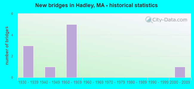
- New bridges - historical statistics
- 31930-1939
- 11940-1949
- 51950-1959
- 12000-2009


- Bridge Condition - Deck
- 33.3%Good
- 16.7%Satisfactory
- 33.3%Fair
- 16.7%Poor

- Bridge Condition - Superstructure
- 16.7%Good
- 33.3%Satisfactory
- 33.3%Fair
- 16.7%Poor

- Bridge Condition - Substructure
- 16.7%Good
- 66.7%Satisfactory
- 16.7%Fair

- Bridge Condition - Channel
- 25.0%Good
- 62.5%Satisfactory
- 12.5%Fair

- Bridge Condition - Culverts
- 50.0%Satisfactory
- 50.0%Fair
Find on map >> Show street view
Structure Number: H0100112KDOTNBI, Location: 3.2 M S SUNDERLAND T.L. (Lat: 42.383608, Lng: -72.583331), Route carried "on" structure: State highway 47, Year Built: 1937, Status: Open, Structure Length: 0.98m (3.22ft), Average Daily Traffic: 3,362 (year 2017), Truck Traffic: 9%, Average Future Daily Traffic: 6,317 (year 2032), Design Load: H 20, Features Intersected: WATER MILL RIVER
Minimum Vertical Clearance: 30+ m (98+ ft), Kilometerpoint: 17.284, Lanes on structure: 2, Owner: State Highway Agency, Approaching Roadway Width: 9.1m (29.9ft), Skew: 1 degrees, Material/Design: Concrete, Design/Construction: Culvert, Number Of Spans In Main Unit: 1, Length of Maximum Span: 9.8m (32.2ft), Curb or Sidewalk Widths: Left: 1.8m (5.9ft), Right: 0.0m
Condition: Channel: Good, Culverts: Fair, Inventory Rating: 37.5 metric tons, Method Used To Determine Inventory Rating: Allowable Stress (AS), Structural Evaluation: Somewhat better than minimum adequacy, Waterway Adequacy: Better than present minimum criteria, Approach Roadway Alignment: Meets minimum limits, Length Of Structure Improvement: 1.00m (3.28ft), Designated Inspection Frequency: Every 24 months, Inspection Date: December 2021, Bridge Improvement Cost: $371,000, Roadway Improvement Cost: $38,000, Total Project Cost: $557,000 ( Estimate for 2022)
Find on map >> Show street view
Structure Number: H01002AXWMUNNBI, Location: N.HADLEY @ LAKE WARNER (Lat: 42.385806, Lng: -72.581167), Route carried "on" structure: City street , Year Built: 2002, Status: Open, Structure Length: 2.58m (8.46ft), Average Daily Traffic: 660 (year 2017), Truck Traffic: 6%, Average Future Daily Traffic: 1,042 (year 2032), Design Load: HS 20, Features Intersected: WATER MILL RIVER, Facility Carried by Structure: HWY MT WARNER RD
Minimum Vertical Clearance: 30+ m (98+ ft), Kilometerpoint: 2.350, Lanes on structure: 2, Owner: Town or Township Highway Agency, Approaching Roadway Width: 7.0m (23.0ft), Material/Design: Steel, Design/Construction: Stringer/Multi-beam, Number Of Spans In Main Unit: 1, Length of Maximum Span: 24.8m (81.4ft), Curb or Sidewalk Widths: Left: 0.0m, Right: 1.6m (5.2ft), Curb-To-Curb Width: 7.0m (23.0ft), Out-to-Out Width: 9.5m (31.2ft)
Condition: Deck: Good, Superstructure: Good, Substructure: Good, Channel: Good, Operating Rating: 72.9 metric tons, Method Used To Determine Operating Rating: Load Factor (LF), Inventory Rating: 43.7 metric tons, Method Used To Determine Inventory Rating: Load Factor (LF), Structural Evaluation: Better than present minimum criteria, Deck Geometry: Meets minimum limits, Waterway Adequacy: Superior to present desirable criteria, Approach Roadway Alignment: Equal to present desirable criteria, Length Of Structure Improvement: 2.60m (8.53ft), Designated Inspection Frequency: Every 24 months, Inspection Date: December 2021, Bridge Improvement Cost: $1,275,000, Roadway Improvement Cost: $128,000, Total Project Cost: $1,913,000 ( Estimate for 2022), Deck Structure Type: Concrete Cast-file-Place, Wearing Surface/Protective System: Wearing Surface: Bituminous, Membrane: Preformed Fabric, Deck Protection: Epoxy Coated Reinforcing
Find on map >> Show street view
Structure Number: H0100512JDOTNBI, Location: .1 M S JCT MIDDLE ST. (Lat: 42.332675, Lng: -72.578686), Route carried "on" structure: State highway 47, Year Built: 1935, Status: Open, Structure Length: 3.84m (12.60ft), Average Daily Traffic: 9,357 (year 2019), Truck Traffic: 3%, Average Future Daily Traffic: 11,028 (year 2032), Design Load: H 20, Features Intersected: WATER FORT RIVER
Minimum Vertical Clearance: 30+ m (98+ ft), Kilometerpoint: 10.621, Lanes on structure: 2, Base Highway Network: Yes, Owner: State Highway Agency, Approaching Roadway Width: 6.1m (20.0ft), Material/Design: Concrete continuous, Design/Construction: Slab, Number Of Spans In Main Unit: 8, Length of Maximum Span: 4.7m (15.4ft), Curb or Sidewalk Widths: Left: 0.0m, Right: 1.4m (4.6ft), Curb-To-Curb Width: 9.1m (29.9ft), Out-to-Out Width: 11.5m (37.7ft)
Condition: Deck: Fair, Superstructure: Fair, Substructure: Fair, Channel: Satisfactory, Operating Rating: 42.5 metric tons, Method Used To Determine Operating Rating: Load Factor (LF), Inventory Rating: 25.4 metric tons, Method Used To Determine Inventory Rating: Load Factor (LF), Structural Evaluation: Somewhat better than minimum adequacy, Deck Geometry: High priority of corrective action, Waterway Adequacy: Better than present minimum criteria, Approach Roadway Alignment: Equal to present desirable criteria, Length Of Structure Improvement: 3.90m (12.80ft), Designated Inspection Frequency: Every 24 months, Inspection Date: October 2021, Bridge Improvement Cost: $1,762,000, Roadway Improvement Cost: $177,000, Total Project Cost: $2,644,000 ( Estimate for 2022), Deck Structure Type: Concrete Cast-file-Place, Wearing Surface/Protective System: Wearing Surface: Bituminous, Membrane: Built-up
Find on map >> Show street view
Structure Number: H010060QDMUNNBI, Location: 1.1 MI. SO. OF RTE. 9 (Lat: 42.341389, Lng: -72.550217), Route carried "on" structure: City street , Year Built: 1957, Status: Open, Structure Length: 1.32m (4.33ft), Average Daily Traffic: 6,538 (year 2015), Truck Traffic: 4%, Average Future Daily Traffic: 3,885 (year 2031), Features Intersected: WATER FORT RIVER, Facility Carried by Structure: HWY S MAPLE ST
Minimum Vertical Clearance: 30+ m (98+ ft), Kilometerpoint: 0.177, Lanes on structure: 2, Owner: Town or Township Highway Agency, Approaching Roadway Width: 6.1m (20.0ft), Material/Design: Steel, Design/Construction: Culvert, Number Of Spans In Main Unit: 2, Length of Maximum Span: 6.2m (20.3ft)
Condition: Channel: Satisfactory, Culverts: Satisfactory, Structural Evaluation: Equal to present minimum criteria, Waterway Adequacy: Superior to present desirable criteria, Approach Roadway Alignment: Better than present minimum criteria, Length Of Structure Improvement: 0.80m (2.62ft), Designated Inspection Frequency: Every 24 months, Underwater Inspection Frequency: Every 36 months, Inspection Date: June 2020, Underwater Inspection Date: September 2021, Bridge Improvement Cost: $996,000, Roadway Improvement Cost: $100,000, Total Project Cost: $1,495,000 ( Estimate for 2022), Wearing Surface/Protective System: Wearing Surface: Bituminous
Find on map >> Show street view
Structure Number: H010090LPMUNNBI, Location: .75 MI E OF RTE 47 (Lat: 42.330111, Lng: -72.563917), Route carried "on" structure: City street , Year Built: 1940, Status: Open, Structure Length: 0.80m (2.62ft), Average Daily Traffic: 8,793 (year 2015), Truck Traffic: 6%, Average Future Daily Traffic: 10,212 (year 2032), Features Intersected: WATER HARTS BROOK, Facility Carried by Structure: HWY BAY RD
Minimum Vertical Clearance: 30+ m (98+ ft), Kilometerpoint: 2.301, Lanes on structure: 2, Owner: Town or Township Highway Agency, Approaching Roadway Width: 9.1m (29.9ft), Material/Design: Steel, Design/Construction: Stringer/Multi-beam, Number Of Spans In Main Unit: 1, Length of Maximum Span: 7.1m (23.3ft), Curb-To-Curb Width: 9.1m (29.9ft), Out-to-Out Width: 15.7m (51.5ft)
Condition: Deck: Satisfactory, Superstructure: Satisfactory, Substructure: Satisfactory, Channel: Satisfactory, Operating Rating: 60.1 metric tons, Method Used To Determine Operating Rating: Load Factor (LF), Inventory Rating: 36.1 metric tons, Method Used To Determine Inventory Rating: Load Factor (LF), Structural Evaluation: Equal to present minimum criteria, Deck Geometry: High priority of corrective action, Waterway Adequacy: Meets minimum limits, Approach Roadway Alignment: Better than present minimum criteria, Length Of Structure Improvement: 0.90m (2.95ft), Designated Inspection Frequency: Every 24 months, Inspection Date: June 2021, Bridge Improvement Cost: $365,000, Roadway Improvement Cost: $37,000, Total Project Cost: $548,000 ( Estimate for 2022), Deck Structure Type: Concrete Cast-file-Place, Wearing Surface/Protective System: Wearing Surface: Bituminous
Find on map >> Show street view
Structure Number: H010120UUDOTNBI, Location: 250' E JCT DAMON RD. (Lat: 42.335953, Lng: -72.618233), Route carried "on" structure: State highway 9, Year Built: 1937, Year Reconstructed: 2003, Status: Open, Structure Length: 43.92m (144.09ft), Average Daily Traffic: 32,314 (year 2018), Truck Traffic: 10%, Average Future Daily Traffic: 53,064 (year 2031), Design Load: HS 20, Features Intersected: WATER CONNECTICUT RIVER
Minimum Vertical Clearance: 30+ m (98+ ft), Kilometerpoint: 75.315, Lanes on structure: 4, Base Highway Network: Yes, Owner: State Highway Agency, Approaching Roadway Width: 16.2m (53.1ft), Design/Construction: Mixed types, Number Of Spans In Main Unit: 5, Number Of Approach Spans: 8, Length of Maximum Span: 90.2m (295.9ft), Curb or Sidewalk Widths: Left: 1.5m (4.9ft), Right: 0.0m, Curb-To-Curb Width: 16.2m (53.1ft), Out-to-Out Width: 19.0m (62.3ft)
Condition: Deck: Good, Superstructure: Satisfactory, Substructure: Satisfactory, Channel: Satisfactory, Operating Rating: 42.7 metric tons, Method Used To Determine Operating Rating: Load Factor (LF), Inventory Rating: 25.6 metric tons, Method Used To Determine Inventory Rating: Load Factor (LF), Structural Evaluation: Equal to present minimum criteria, Deck Geometry: Meets minimum limits, Waterway Adequacy: Equal to present desirable criteria, Approach Roadway Alignment: Equal to present desirable criteria, Length Of Structure Improvement: 44.00m (144.36ft), Designated Inspection Frequency: Every 24 months, Critical Feature Inspection Frequency: Every 24 months, Underwater Inspection Frequency: Every 36 months, Inspection Date: October 2020, Critical Feature Inspection Date: October 2020, Underwater Inspection Date: August 2019, Bridge Improvement Cost: $32,839,000, Roadway Improvement Cost: $3,284,000, Total Project Cost: $49,259,000 ( Estimate for 2022), Deck Structure Type: Concrete Cast-file-Place, Wearing Surface/Protective System: Wearing Surface: Bituminous, Membrane: Built-up, Deck Protection: Epoxy Coated Reinforcing
Find on map >> Show street view
Structure Number: H0101513ADOTNBI, Location: .4 M W AMHERST T.L. (Lat: 42.373556, Lng: -72.542208), Route carried "on" structure: City street , Year Built: 1958, Status: Open, Structure Length: 6.52m (21.39ft), Average Daily Traffic: 12,931 (year 2018), Truck Traffic: 1%, Average Future Daily Traffic: 1,106 (year 2033), Design Load: H 20, Features Intersected: ST116, Facility Carried by Structure: HWY RCKY HILL RD
Minimum Vertical Clearance: 30+ m (98+ ft), Kilometerpoint: 0.805, Lanes on structure: 2, Lanes under structure: 4, Owner: State Highway Agency, Approaching Roadway Width: 9.8m (32.2ft), Skew: 1 degrees, Material/Design: Prestressed concrete, Design/Construction: Stringer/Multi-beam, Number Of Spans In Main Unit: 4, Length of Maximum Span: 19.3m (63.3ft), Curb or Sidewalk Widths: Left: 1.5m (4.9ft), Right: 0.5m (1.6ft), Curb-To-Curb Width: 9.8m (32.2ft), Out-to-Out Width: 12.4m (40.7ft)
Condition: Deck: Fair, Superstructure: Fair, Substructure: Satisfactory, Operating Rating: 66.1 metric tons, Method Used To Determine Operating Rating: Load Factor (LF), Inventory Rating: 39.6 metric tons, Method Used To Determine Inventory Rating: Load Factor (LF), Structural Evaluation: Somewhat better than minimum adequacy, Deck Geometry: Meets minimum limits, Underclear: Meets minimum limits, Approach Roadway Alignment: Better than present minimum criteria, Length Of Structure Improvement: 6.60m (21.65ft), Designated Inspection Frequency: Every 24 months, Inspection Date: Febuary 2022, Bridge Improvement Cost: $3,215,000, Roadway Improvement Cost: $322,000, Total Project Cost: $4,823,000 ( Estimate for 2022), Deck Structure Type: Concrete Cast-file-Place, Wearing Surface/Protective System: Wearing Surface: Integral Concrete
Find on map >> Show street view
Structure Number: H0101713BDOTNBI, Location: .4 M W AMHERST T.L. (Lat: 42.384292, Lng: -72.540861), Route carried "on" structure: City street , Year Built: 1958, Status: Open, Structure Length: 6.53m (21.42ft), Average Daily Traffic: 9,429 (year 2018), Truck Traffic: 1%, Average Future Daily Traffic: 17,972 (year 2033), Design Load: H 20, Features Intersected: ST116, Facility Carried by Structure: HWY N HADLEY RD
Minimum Vertical Clearance: 30+ m (98+ ft), Kilometerpoint: 0.000, Lanes on structure: 2, Lanes under structure: 6, Owner: State Highway Agency, Approaching Roadway Width: 12.2m (40.0ft), Material/Design: Prestressed concrete, Design/Construction: Stringer/Multi-beam, Number Of Spans In Main Unit: 4, Length of Maximum Span: 19.6m (64.3ft), Curb or Sidewalk Widths: Left: 0.5m (1.6ft), Right: 1.5m (4.9ft), Curb-To-Curb Width: 12.2m (40.0ft), Out-to-Out Width: 14.9m (48.9ft)
Condition: Deck: Poor, Superstructure: Poor, Substructure: Satisfactory, Operating Rating: 56.6 metric tons, Method Used To Determine Operating Rating: Load Factor (LF), Inventory Rating: 35.4 metric tons, Method Used To Determine Inventory Rating: Load Factor (LF), Structural Evaluation: Meets minimum limits, Deck Geometry: Somewhat better than minimum adequacy, Underclear: Meets minimum limits, Approach Roadway Alignment: Equal to present desirable criteria, Length Of Structure Improvement: 6.60m (21.65ft), Designated Inspection Frequency: Every 12 months, Other Special Inspection Frequency: Every 12 months, Inspection Date: Febuary 2022, Other Special Inspection Date: Febuary 2021, Bridge Improvement Cost: $3,863,000, Roadway Improvement Cost: $387,000, Total Project Cost: $5,795,000 ( Estimate for 2022), Deck Structure Type: Concrete Cast-file-Place, Wearing Surface/Protective System: Wearing Surface: Integral Concrete
Find on map >> Show street view
Structure Number: H010180VEDOTNBI, Location: 1 M S AMHERST-HADLY T.L. (Lat: 42.387508, Lng: -72.540464), Route carried "on" structure: State highway 116, Year Built: 1958, Status: Open, Structure Length: 1.98m (6.50ft), Average Daily Traffic: 24,181 (year 2015), Truck Traffic: 7%, Average Future Daily Traffic: 23,279 (year 2032), Design Load: H 20, Features Intersected: WATER MILL RIVER
Minimum Vertical Clearance: 30+ m (98+ ft), Kilometerpoint: 35.646, Lanes on structure: 4, Base Highway Network: Yes, Owner: State Highway Agency, Approaching Roadway Width: 11.6m (38.1ft), Skew: 21 degrees, Material/Design: Concrete continuous, Design/Construction: Culvert, Number Of Spans In Main Unit: 3, Length of Maximum Span: 6.4m (21.0ft)
Condition: Channel: Fair, Culverts: Fair, Inventory Rating: 74.5 metric tons, Method Used To Determine Inventory Rating: Load Factor (LF), Structural Evaluation: Somewhat better than minimum adequacy, Waterway Adequacy: Equal to present desirable criteria, Approach Roadway Alignment: Equal to present desirable criteria, Length Of Structure Improvement: 1.30m (4.27ft), Designated Inspection Frequency: Every 24 months, Inspection Date: July 2021, Bridge Improvement Cost: $967,000, Roadway Improvement Cost: $97,000, Total Project Cost: $1,451,000 ( Estimate for 2022), Wearing Surface/Protective System: Wearing Surface: Bituminous
Find on map >> Show street view
Structure Number: H010200QCMUNNBI, Location: 0.5MI W OFRT116 (Lat: 42.385667, Lng: -72.548056), Route carried "on" structure: City street , Year Built: 1958, Status: Open, Structure Length: 1.98m (6.50ft), Average Daily Traffic: 5,100 (year 2000), Truck Traffic: 6%, Average Future Daily Traffic: 8,054 (year 2031), Design Load: H 20, Features Intersected: WATER MILL RIVER, Facility Carried by Structure: HWY ROOSEVELT ST
Minimum Vertical Clearance: 30+ m (98+ ft), Kilometerpoint: 0.129, Lanes on structure: 2, Owner: Town or Township Highway Agency, Approaching Roadway Width: 9.8m (32.2ft), Skew: 1 degrees, Material/Design: Concrete, Design/Construction: Culvert, Number Of Spans In Main Unit: 3, Length of Maximum Span: 6.3m (20.7ft)
Condition: Channel: Satisfactory, Culverts: Satisfactory, Operating Rating: 43.7 metric tons, Method Used To Determine Operating Rating: Load Factor (LF), Inventory Rating: 26.2 metric tons, Method Used To Determine Inventory Rating: Load Factor (LF), Structural Evaluation: Equal to present minimum criteria, Waterway Adequacy: Equal to present minimum criteria, Approach Roadway Alignment: Equal to present desirable criteria, Length Of Structure Improvement: 1.10m (3.61ft), Designated Inspection Frequency: Every 24 months, Underwater Inspection Frequency: Every 36 months, Inspection Date: December 2020, Underwater Inspection Date: June 2019, Bridge Improvement Cost: $827,000, Roadway Improvement Cost: $83,000, Total Project Cost: $1,241,000 ( Estimate for 2022)