Bridge Statistics for Hale Center, Texas (TX)
Condition, Traffic, Stress, Structural Evaluation, Project Costs
- National Bridge Inventory (NBI) Statistics
- 12Number of bridges
- 141ft / 43.5mTotal length
- $16,000Total costs
- 70,408Total average daily traffic
- 11,805Total average daily truck traffic
- National Bridge Inventory (NBI) Registered Bridges for Hale Center
- No street view available for this location
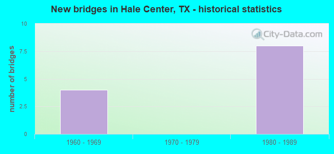
- New bridges - historical statistics
- 41960-1969
- 81980-1989


- Bridge Condition - Deck
- 16.7%Very good
- 16.7%Good
- 66.7%Satisfactory

- Bridge Condition - Superstructure
- 50.0%Good
- 50.0%Satisfactory

- Bridge Condition - Substructure
- 33.3%Good
- 66.7%Satisfactory
Find on map >> Show street view
Structure Number: 50960006705046, Location: 0.30 MI N OF FM 1914 (Lat: 34.069853, Lng: -101.842736), Route carried "on" structure: Interstate 27, Year Built: 1962, Year Reconstructed: 1982, Status: Open, Structure Length: 4.85m (15.91ft), Average Daily Traffic: 15,140 (year 2020), Truck Traffic: 17%, Average Future Daily Traffic: 16,990 (year 2033), Features Intersected: 12TH ST
Minimum Vertical Clearance: 30+ m (98+ ft), Kilometerpoint: 27.589, Lanes on structure: 4, Lanes under structure: 4, Owner: State Highway Agency, Approaching Roadway Width: 24.4m (80.1ft), Skew: 30 degrees, Material/Design: Concrete continuous, Design/Construction: Slab, Number Of Spans In Main Unit: 4, Length of Maximum Span: 13.7m (44.9ft), Curb-To-Curb Width: 24.1m (79.1ft), Out-to-Out Width: 25.6m (84.0ft)
Condition: Deck: Satisfactory, Superstructure: Satisfactory, Substructure: Satisfactory, Operating Rating: 68.0 metric tons, Method Used To Determine Operating Rating: Load Factor (LF), Inventory Rating: 40.8 metric tons, Method Used To Determine Inventory Rating: Load Factor (LF), Structural Evaluation: Equal to present minimum criteria, Deck Geometry: Superior to present desirable criteria, Underclear: Equal to present minimum criteria, Approach Roadway Alignment: Equal to present desirable criteria, Length Of Structure Improvement: 4.88m (16.01ft), Designated Inspection Frequency: Every 24 months, Inspection Date: August 2021, Bridge Improvement Cost: $13,000, Roadway Improvement Cost: $3,000, Total Project Cost: $16,000, Deck Structure Type: Concrete Cast-file-Place, Wearing Surface/Protective System: Wearing Surface: Monolithic Concrete
Find on map >> Show street view
Structure Number: 50960006705103, Location: FM 1914 @ IH 27 (Lat: 34.064408, Lng: -101.843653), Route carried "on" structure: State highway 1914, Year Built: 1982, Status: Open, Structure Length: 4.24m (13.91ft), Average Daily Traffic: 1,930 (year 2013), Truck Traffic: 9%, Average Future Daily Traffic: 2,700 (year 2033), Design Load: HS 20, Features Intersected: IH 27
Minimum Vertical Clearance: 30+ m (98+ ft), Kilometerpoint: 15.607, Lanes on structure: 2, Lanes under structure: 4, Owner: State Highway Agency, Approaching Roadway Width: 17.1m (56.1ft), Material/Design: Prestressed concrete, Design/Construction: Box Beam or Girders - Multiple, Number Of Spans In Main Unit: 2, Length of Maximum Span: 21.0m (68.9ft), Curb or Sidewalk Widths: Left: 1.4m (4.6ft), Right: 1.4m (4.6ft), Curb-To-Curb Width: 17.2m (56.4ft), Out-to-Out Width: 20.6m (67.6ft)
Condition: Deck: Very good, Superstructure: Good, Substructure: Satisfactory, Operating Rating: 54.4 metric tons, Method Used To Determine Operating Rating: Assigned rating based on Load Factor Design (LFD) reported in metric tons, Inventory Rating: 32.7 metric tons, Method Used To Determine Inventory Rating: Assigned rating based on Load Factor Design (LFD) reported in metric tons, Structural Evaluation: Equal to present minimum criteria, Deck Geometry: Superior to present desirable criteria, Underclear: Meets minimum limits, Approach Roadway Alignment: Equal to present desirable criteria, Designated Inspection Frequency: Every 24 months, Inspection Date: August 2021, Deck Structure Type: Concrete Precast Panels, Wearing Surface/Protective System: Wearing Surface: Bituminous
Find on map >> Show street view
Structure Number: 50960006705109, Location: 3.3 MI N OF FM 1914 (Lat: 34.093789, Lng: -101.800733), Route carried "on" structure: County highway , Year Built: 1982, Status: Open, Structure Length: 17.83m (58.50ft), Average Daily Traffic: 100 (year 2010), Average Future Daily Traffic: 150 (year 2030), Design Load: HS 20, Features Intersected: IH 27 & BNSF RR, Facility Carried by Structure: CR 155 & CR R
Minimum Vertical Clearance: 30+ m (98+ ft), Kilometerpoint: 0.805, Lanes on structure: 2, Lanes under structure: 10, Owner: State Highway Agency, Approaching Roadway Width: 10.4m (34.1ft), Material/Design: Prestressed concrete, Design/Construction: Stringer/Multi-beam, Number Of Spans In Main Unit: 6, Number Of Approach Spans: 2, Length of Maximum Span: 27.4m (89.9ft), Curb-To-Curb Width: 10.2m (33.5ft), Out-to-Out Width: 11.0m (36.1ft)
Condition: Deck: Good, Superstructure: Good, Substructure: Good, Operating Rating: 54.4 metric tons, Method Used To Determine Operating Rating: Assigned rating based on Load Factor Design (LFD) reported in metric tons, Inventory Rating: 32.7 metric tons, Method Used To Determine Inventory Rating: Assigned rating based on Load Factor Design (LFD) reported in metric tons, Structural Evaluation: Better than present minimum criteria, Deck Geometry: Superior to present desirable criteria, Underclear: Better than present minimum criteria, Approach Roadway Alignment: Equal to present desirable criteria, Designated Inspection Frequency: Every 24 months, Inspection Date: August 2021, Deck Structure Type: Concrete Cast-file-Place, Wearing Surface/Protective System: Wearing Surface: Bituminous
Find on map >> Show street view
Structure Number: 509600067061, Location: 1.40 MI S OF FM 1914 (Lat: 34.047669, Lng: -101.853331), Route carried "on" structure: Interstate 27, Year Built: 1982, Status: Open, Structure Length: 5.85m (19.19ft), Average Daily Traffic: 7,686 (year 2019), Truck Traffic: 17%, Average Future Daily Traffic: 7,690 (year 2033), Design Load: HS 20, Features Intersected: FM 1424
Minimum Vertical Clearance: 30+ m (98+ ft), Kilometerpoint: 24.683, Lanes on structure: 2, Lanes under structure: 4, Owner: State Highway Agency, Approaching Roadway Width: 11.6m (38.1ft), Material/Design: Prestressed concrete continuous, Design/Construction: Stringer/Multi-beam, Number Of Spans In Main Unit: 2, Length of Maximum Span: 29.3m (96.1ft), Curb-To-Curb Width: 12.6m (41.3ft), Out-to-Out Width: 13.5m (44.3ft)
Condition: Deck: Satisfactory, Superstructure: Good, Substructure: Good, Operating Rating: 54.4 metric tons, Method Used To Determine Operating Rating: Assigned rating based on Load Factor Design (LFD) reported in metric tons, Inventory Rating: 32.7 metric tons, Method Used To Determine Inventory Rating: Assigned rating based on Load Factor Design (LFD) reported in metric tons, Structural Evaluation: Better than present minimum criteria, Deck Geometry: Better than present minimum criteria, Underclear: Superior to present desirable criteria, Approach Roadway Alignment: Equal to present desirable criteria, Designated Inspection Frequency: Every 24 months, Inspection Date: August 2021, Deck Structure Type: Concrete Cast-file-Place
Find on map >> Show street view
Structure Number: 50960006706101, Location: 1.40 MI S OF FM 1914 (Lat: 34.047700, Lng: -101.853542), Route carried "on" structure: Interstate 27, Year Built: 1982, Status: Open, Structure Length: 5.85m (19.19ft), Average Daily Traffic: 7,492 (year 2019), Truck Traffic: 17%, Average Future Daily Traffic: 7,690 (year 2033), Design Load: HS 20, Features Intersected: FM 1424
Minimum Vertical Clearance: 30+ m (98+ ft), Kilometerpoint: 24.683, Lanes on structure: 2, Lanes under structure: 4, Owner: State Highway Agency, Approaching Roadway Width: 11.6m (38.1ft), Material/Design: Prestressed concrete continuous, Design/Construction: Stringer/Multi-beam, Number Of Spans In Main Unit: 2, Length of Maximum Span: 29.3m (96.1ft), Curb-To-Curb Width: 12.6m (41.3ft), Out-to-Out Width: 13.5m (44.3ft)
Condition: Deck: Satisfactory, Superstructure: Satisfactory, Substructure: Satisfactory, Operating Rating: 54.4 metric tons, Method Used To Determine Operating Rating: Assigned rating based on Load Factor Design (LFD) reported in metric tons, Inventory Rating: 32.7 metric tons, Method Used To Determine Inventory Rating: Assigned rating based on Load Factor Design (LFD) reported in metric tons, Structural Evaluation: Equal to present minimum criteria, Deck Geometry: Better than present minimum criteria, Underclear: Superior to present desirable criteria, Approach Roadway Alignment: Equal to present desirable criteria, Designated Inspection Frequency: Every 24 months, Inspection Date: August 2021, Deck Structure Type: Concrete Cast-file-Place
Find on map >> Show street view
Structure Number: 50960006706102, Location: 0.66 MI S OF FM 1914 (Lat: 34.055569, Lng: -101.845858), Route carried "on" structure: Interstate 27, Year Built: 1962, Year Reconstructed: 1982, Status: Open, Structure Length: 4.85m (15.91ft), Average Daily Traffic: 13,660 (year 2020), Truck Traffic: 17%, Average Future Daily Traffic: 14,860 (year 2033), Features Intersected: FRTG RD TURNAROUND
Minimum Vertical Clearance: 30+ m (98+ ft), Kilometerpoint: 25.896, Lanes on structure: 4, Lanes under structure: 4, Owner: State Highway Agency, Approaching Roadway Width: 24.4m (80.1ft), Skew: 30 degrees, Material/Design: Concrete continuous, Design/Construction: Slab, Number Of Spans In Main Unit: 4, Length of Maximum Span: 13.7m (44.9ft), Curb-To-Curb Width: 24.1m (79.1ft), Out-to-Out Width: 25.6m (84.0ft)
Condition: Deck: Satisfactory, Superstructure: Satisfactory, Substructure: Satisfactory, Operating Rating: 68.0 metric tons, Method Used To Determine Operating Rating: Load Factor (LF), Inventory Rating: 40.8 metric tons, Method Used To Determine Inventory Rating: Load Factor (LF), Structural Evaluation: Equal to present minimum criteria, Deck Geometry: Superior to present desirable criteria, Underclear: High priority of corrective action, Approach Roadway Alignment: Equal to present desirable criteria, Length Of Structure Improvement: 4.88m (16.01ft), Designated Inspection Frequency: Every 24 months, Inspection Date: August 2021, Deck Structure Type: Concrete Cast-file-Place, Wearing Surface/Protective System: Wearing Surface: Monolithic Concrete
Find on map >> Show street view
Structure Number: 50960006705046, Location: 0.30 MI N OF FM 1914 (Lat: 34.069800, Lng: -101.842700), Route carried "under" structure: City street 12, Year Built: 1962, Structure Length: 0. m, Average Daily Traffic: 100 (year 2009), Features Intersected: 12TH ST, Facility Carried by Structure: IH 27
Minimum Vertical Clearance: 4.52m (14.83ft), Lanes on structure: 4, Material/Design: Concrete continuous, Design/Construction: Slab, Length of Maximum Span: 13.7m (44.9ft)
Find on map >> Show street view
Structure Number: 50960006705103, Location: FM 1914 @ IH 27 (Lat: 34.064408, Lng: -101.843653), Route carried "under" structure: Interstate 27, Year Built: 1982, Structure Length: 0. m, Average Daily Traffic: 10,610 (year 2013), Truck Traffic: 17%, Features Intersected: IH 27, Facility Carried by Structure: FM 1914
Minimum Vertical Clearance: 5.21m (17.09ft), Kilometerpoint: 26.995, Lanes on structure: 4, Material/Design: Prestressed concrete, Design/Construction: Box Beam or Girders - Multiple, Length of Maximum Span: 21.0m (68.9ft)
Find on map >> Show street view
Structure Number: 50960006705109, Location: 3.3 MI N OF FM 1914 (Lat: 34.093789, Lng: -101.800733), Route carried "under" structure: Interstate 27, Year Built: 1982, Structure Length: 0. m, Average Daily Traffic: 12,130 (year 2013), Truck Traffic: 17%, Features Intersected: IH 27 & BNSF RR, Facility Carried by Structure: CR 155 & CR R
Minimum Vertical Clearance: 7.24m (23.75ft), Kilometerpoint: 32.356, Lanes on structure: 10, Material/Design: Prestressed concrete, Design/Construction: Stringer/Multi-beam, Length of Maximum Span: 27.4m (89.9ft)
Find on map >> Show street view
Structure Number: 509600067061, Location: 1.40 MI S OF FM 1914 (Lat: 34.047500, Lng: -101.853300), Route carried "under" structure: State highway 1424, Year Built: 1982, Structure Length: 0. m, Average Daily Traffic: 730 (year 2013), Truck Traffic: 20%, Features Intersected: FM 1424, Facility Carried by Structure: IH 27 NB
Minimum Vertical Clearance: 5.23m (17.16ft), Kilometerpoint: 18.026, Lanes on structure: 2, Material/Design: Prestressed concrete continuous, Design/Construction: Stringer/Multi-beam, Length of Maximum Span: 29.3m (96.1ft)
Find on map >> Show street view
Structure Number: 50960006706101, Location: 1.40 MI S OF FM 1914 (Lat: 34.047700, Lng: -101.853500), Route carried "under" structure: State highway 1424, Year Built: 1982, Structure Length: 0. m, Average Daily Traffic: 730 (year 2013), Truck Traffic: 20%, Features Intersected: FM 1424, Facility Carried by Structure: IH 27 SB
Minimum Vertical Clearance: 5.41m (17.75ft), Kilometerpoint: 18.046, Lanes on structure: 4, Material/Design: Prestressed concrete continuous, Design/Construction: Stringer/Multi-beam, Length of Maximum Span: 29.3m (96.1ft)
Find on map >> Show street view
Structure Number: 50960006706102, Location: 0.66 MI S OF FM 1914 (Lat: 34.055500, Lng: -101.845800), Route carried "under" structure: City street , Year Built: 1962, Structure Length: 0. m, Average Daily Traffic: 100 (year 2009), Truck Traffic: 1%, Features Intersected: FRTG RD TURNAROUND, Facility Carried by Structure: IH 27
Minimum Vertical Clearance: 4.40m (14.44ft), Lanes on structure: 4, Material/Design: Concrete continuous, Design/Construction: Slab, Length of Maximum Span: 13.7m (44.9ft)