Bridge Statistics for Hamilton, Virginia (VA)
Condition, Traffic, Stress, Structural Evaluation, Project Costs
- National Bridge Inventory (NBI) Statistics
- 18Number of bridges
- 187ft / 57.1mTotal length
- $1,613,000Total costs
- 206,510Total average daily traffic
- 6,302Total average daily truck traffic
- National Bridge Inventory (NBI) Registered Bridges for Hamilton
- No street view available for this location
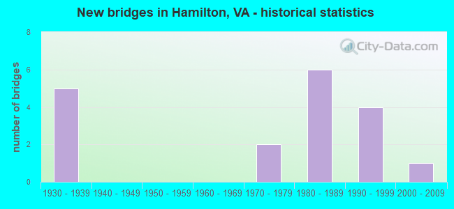
- New bridges - historical statistics
- 51930-1939
- 21970-1979
- 61980-1989
- 41990-1999
- 12000-2009


- Bridge Condition - Deck
- 9.1%Very good
- 54.5%Good
- 18.2%Satisfactory
- 18.2%Fair

- Bridge Condition - Superstructure
- 8.3%Very good
- 41.7%Good
- 25.0%Satisfactory
- 16.7%Fair
- 8.3%Poor

- Bridge Condition - Substructure
- 41.7%Good
- 58.3%Satisfactory

- Bridge Condition - Channel
- 20.0%Very good
- 20.0%Good
- 30.0%Satisfactory
- 30.0%Fair

- Bridge Condition - Culverts
- 50.0%Good
- 50.0%Satisfactory
Find on map >> Show street view
Structure Number: 3057, Location: 1.1M to 98 & .70 M to END (Lat: 37.093053, Lng: -81.098536), Route carried "on" structure: County highway 605, Year Built: 1974, Status: Posted for load, Structure Length: 2.04m (6.69ft), Average Daily Traffic: 130 (year 2015), Average Future Daily Traffic: 146 (year 2040), Design Load: HS 20, Features Intersected: BIG WALKER CREEK #2
Minimum Vertical Clearance: 30+ m (98+ ft), Kilometerpoint: 0.785, Lanes on structure: 2, Owner: State Highway Agency, Approaching Roadway Width: 4.9m (16.1ft), Skew: 3 degrees, Material/Design: Steel, Design/Construction: Stringer/Multi-beam, Number Of Spans In Main Unit: 2, Length of Maximum Span: 10.1m (33.1ft), Curb or Sidewalk Widths: Left: 0.2m (0.7ft), Right: 0.2m (0.7ft), Curb-To-Curb Width: 7.9m (25.9ft), Out-to-Out Width: 8.3m (27.2ft)
Condition: Deck: Good, Superstructure: Fair, Substructure: Satisfactory, Channel: Fair, Operating Rating: 37.2 metric tons, Method Used To Determine Operating Rating: Load Factor (LF), Inventory Rating: 21.8 metric tons, Method Used To Determine Inventory Rating: Load Factor (LF), Structural Evaluation: Somewhat better than minimum adequacy, Deck Geometry: Somewhat better than minimum adequacy, Waterway Adequacy: Better than present minimum criteria, Approach Roadway Alignment: Better than present minimum criteria, Designated Inspection Frequency: Every 24 months, Inspection Date: November 2021, Deck Structure Type: Wood or Timber, Wearing Surface/Protective System: Wearing Surface: Bituminous
Find on map >> Show street view
Structure Number: 4676, Location: 0.25-Rte674; 0.70-Rte683 (Lat: 36.713183, Lng: -80.644497), Route carried "on" structure: County highway 670, Year Built: 1974, Status: Open, Structure Length: 0.73m (2.40ft), Average Daily Traffic: 576 (year 2020), Truck Traffic: 5%, Average Future Daily Traffic: 592 (year 2040), Design Load: HS 20, Features Intersected: Snake Creek
Minimum Vertical Clearance: 30+ m (98+ ft), Kilometerpoint: 9.358, Lanes on structure: 2, Owner: State Highway Agency, Approaching Roadway Width: 6.1m (20.0ft), Skew: 2 degrees, Material/Design: Steel, Design/Construction: Culvert, Number Of Spans In Main Unit: 2, Length of Maximum Span: 3.7m (12.1ft)
Condition: Channel: Satisfactory, Culverts: Satisfactory, Operating Rating: 44.5 metric tons, Method Used To Determine Operating Rating: Field evaluation and documented engineering judgment, Inventory Rating: 32.7 metric tons, Method Used To Determine Inventory Rating: Field evaluation and documented engineering judgment, Structural Evaluation: Equal to present minimum criteria, Waterway Adequacy: Better than present minimum criteria, Approach Roadway Alignment: Equal to present desirable criteria, Designated Inspection Frequency: Every 24 months, Inspection Date: Febuary 2021
Find on map >> Show street view
Structure Number: 5381, Location: 0.30 TO 638 - 0.25 TO 622 (Lat: 39.042292, Lng: -78.000481), Route carried "on" structure: US 17, Year Built: 1980, Status: Open, Structure Length: 33.38m (109.51ft), Average Daily Traffic: 6,539 (year 2020), Truck Traffic: 6%, Average Future Daily Traffic: 8,455 (year 2040), Design Load: HS 20+Mod, Features Intersected: SHENANDOAH RIVER & RT622, Facility Carried by Structure: JOHN MOSBY HWY-SBL
Minimum Vertical Clearance: 30+ m (98+ ft), Kilometerpoint: 48.967, Lanes on structure: 2, Lanes under structure: 2, Base Highway Network: Yes, Owner: State Highway Agency, Approaching Roadway Width: 7.3m (24.0ft), Material/Design: Steel continuous, Design/Construction: Stringer/Multi-beam, Number Of Spans In Main Unit: 4, Number Of Approach Spans: 9, Length of Maximum Span: 52.4m (171.9ft), Curb-To-Curb Width: 11.2m (36.7ft), Out-to-Out Width: 12.2m (40.0ft)
Condition: Deck: Satisfactory, Superstructure: Satisfactory, Substructure: Satisfactory, Channel: Very good, Operating Rating: 71.7 metric tons, Method Used To Determine Operating Rating: Load and Resistance Factor (LRFR), Inventory Rating: 55.3 metric tons, Method Used To Determine Inventory Rating: Load and Resistance Factor (LRFR), Structural Evaluation: Equal to present minimum criteria, Deck Geometry: Equal to present minimum criteria, Underclear: Meets minimum limits, Waterway Adequacy: Equal to present desirable criteria, Approach Roadway Alignment: Better than present minimum criteria, Designated Inspection Frequency: Every 24 months, Underwater Inspection Frequency: Every 60 months, Inspection Date: August 2021, Underwater Inspection Date: July 2019, Deck Structure Type: Concrete Cast-file-Place, Wearing Surface/Protective System: Wearing Surface: Epoxy Overlay, Deck Protection: Epoxy Coated Reinforcing
Find on map >> Show street view
Structure Number: 11052, Location: 02.07FR9/00.21TO704 (Lat: 39.141564, Lng: -77.648183), Route carried "on" structure: State highway 7, Year Built: 1980, Year Reconstructed: 1994, Status: Open, Structure Length: 0.73m (2.40ft), Average Daily Traffic: 47,205 (year 2020), Truck Traffic: 3%, Average Future Daily Traffic: 66,087 (year 2040), Design Load: HS 20, Features Intersected: TRIB.S.FORK CATOCTIN CK.
Minimum Vertical Clearance: 30+ m (98+ ft), Kilometerpoint: 48.930, Lanes on structure: 5, Base Highway Network: Yes, Owner: State Highway Agency, Approaching Roadway Width: 17.7m (58.1ft), Skew: 4 degrees, Material/Design: Concrete, Design/Construction: Culvert, Number Of Spans In Main Unit: 2, Length of Maximum Span: 3.7m (12.1ft)
Condition: Channel: Fair, Culverts: Good, Operating Rating: 89.8 metric tons, Method Used To Determine Operating Rating: Load Factor (LF), Inventory Rating: 60.8 metric tons, Method Used To Determine Inventory Rating: Load Factor (LF), Structural Evaluation: Better than present minimum criteria, Waterway Adequacy: Somewhat better than minimum adequacy, Approach Roadway Alignment: Better than present minimum criteria, Length Of Structure Improvement: 0.30m (0.98ft), Designated Inspection Frequency: Every 24 months, Inspection Date: January 2021, Bridge Improvement Cost: $1,000, Roadway Improvement Cost: $1,000, Total Project Cost: $3,000 ( Estimate for 2015)
Find on map >> Show street view
Structure Number: 11054, Location: 02.33FR9/00.98TO709 (Lat: 39.143094, Lng: -77.652425), Route carried "on" structure: Bypass State highway 7, Year Built: 1980, Status: Open, Structure Length: 3.41m (11.19ft), Average Daily Traffic: 47,205 (year 2020), Truck Traffic: 3%, Average Future Daily Traffic: 66,087 (year 2040), Design Load: HS 20, Features Intersected: HAMILTON STATION ROAD
Minimum Vertical Clearance: 30+ m (98+ ft), Kilometerpoint: 48.511, Lanes on structure: 3, Lanes under structure: 2, Base Highway Network: Yes, Owner: State Highway Agency, Approaching Roadway Width: 15.8m (51.8ft), Material/Design: Steel, Design/Construction: Stringer/Multi-beam, Number Of Spans In Main Unit: 1, Length of Maximum Span: 34.1m (111.9ft), Curb-To-Curb Width: 15.4m (50.5ft), Out-to-Out Width: 16.4m (53.8ft)
Condition: Deck: Good, Superstructure: Satisfactory, Substructure: Good, Operating Rating: 90.6 metric tons, Method Used To Determine Operating Rating: Load and Resistance Factor (LRFR), Inventory Rating: 88.9 metric tons, Method Used To Determine Inventory Rating: Load and Resistance Factor (LRFR), Structural Evaluation: Equal to present minimum criteria, Deck Geometry: Equal to present minimum criteria, Underclear: Superior to present desirable criteria, Approach Roadway Alignment: Equal to present desirable criteria, Length Of Structure Improvement: 3.41m (11.19ft), Designated Inspection Frequency: Every 24 months, Inspection Date: January 2021, Bridge Improvement Cost: $79,000, Roadway Improvement Cost: $150,000, Total Project Cost: $300,000 ( Estimate for 2015), Deck Structure Type: Concrete Cast-file-Place, Wearing Surface/Protective System: Deck Protection: Epoxy Coated Reinforcing
Find on map >> Show street view
Structure Number: 11056, Location: 01.01 704 / 01.16 287 (Lat: 39.145497, Lng: -77.670200), Route carried "on" structure: State highway 7, Year Built: 1980, Status: Open, Structure Length: 3.26m (10.70ft), Average Daily Traffic: 47,587 (year 2020), Truck Traffic: 3%, Average Future Daily Traffic: 66,622 (year 2040), Design Load: HS 20, Features Intersected: IVANDALE ROAD
Minimum Vertical Clearance: 30+ m (98+ ft), Kilometerpoint: 46.902, Lanes on structure: 2, Lanes under structure: 2, Base Highway Network: Yes, Owner: State Highway Agency, Approaching Roadway Width: 12.2m (40.0ft), Material/Design: Steel, Design/Construction: Stringer/Multi-beam, Number Of Spans In Main Unit: 3, Length of Maximum Span: 13.7m (44.9ft), Curb or Sidewalk Widths: Left: 0.2m (0.7ft), Right: 0.2m (0.7ft), Curb-To-Curb Width: 12.2m (40.0ft), Out-to-Out Width: 13.1m (43.0ft)
Condition: Deck: Good, Superstructure: Good, Substructure: Satisfactory, Operating Rating: 89.8 metric tons, Method Used To Determine Operating Rating: Load and Resistance Factor (LRFR), Inventory Rating: 70.8 metric tons, Method Used To Determine Inventory Rating: Load and Resistance Factor (LRFR), Structural Evaluation: Equal to present minimum criteria, Deck Geometry: Somewhat better than minimum adequacy, Underclear: Somewhat better than minimum adequacy, Approach Roadway Alignment: Better than present minimum criteria, Length Of Structure Improvement: 3.26m (10.70ft), Designated Inspection Frequency: Every 24 months, Inspection Date: January 2021, Bridge Improvement Cost: $55,000, Roadway Improvement Cost: $99,000, Total Project Cost: $300,000 ( Estimate for 2015), Deck Structure Type: Concrete Cast-file-Place, Wearing Surface/Protective System: Deck Protection: Epoxy Coated Reinforcing
Find on map >> Show street view
Structure Number: 11294, Location: 00.90FR711/00.10TO9 (Lat: 39.159044, Lng: -77.638867), Route carried "on" structure: County highway 704, Year Built: 1930, Status: Posted for load, Structure Length: 0.70m (2.30ft), Average Daily Traffic: 2,238 (year 2020), Truck Traffic: 4%, Average Future Daily Traffic: 3,133 (year 2040), Design Load: HS 20, Features Intersected: BR S FORK CATOCTIN CREEK, Facility Carried by Structure: HAMILTON STA. ROAD
Minimum Vertical Clearance: 30+ m (98+ ft), Kilometerpoint: 12.148, Lanes on structure: 2, Owner: State Highway Agency, Approaching Roadway Width: 6.7m (22.0ft), Material/Design: Concrete, Design/Construction: Slab, Number Of Spans In Main Unit: 1, Length of Maximum Span: 6.7m (22.0ft), Curb-To-Curb Width: 7.0m (23.0ft), Out-to-Out Width: 7.9m (25.9ft)
Condition: Deck: Satisfactory, Superstructure: Satisfactory, Substructure: Satisfactory, Channel: Satisfactory, Operating Rating: 41.5 metric tons, Method Used To Determine Operating Rating: Load Factor (LF), Inventory Rating: 24.9 metric tons, Method Used To Determine Inventory Rating: Load Factor (LF), Structural Evaluation: Equal to present minimum criteria, Deck Geometry: High priority of replacement, Waterway Adequacy: Somewhat better than minimum adequacy, Approach Roadway Alignment: Equal to present minimum criteria, Length Of Structure Improvement: 0.70m (2.30ft), Designated Inspection Frequency: Every 24 months, Inspection Date: June 2020, Bridge Improvement Cost: $140,000, Roadway Improvement Cost: $14,000, Total Project Cost: $198,000, Deck Structure Type: Concrete Cast-file-Place, Wearing Surface/Protective System: Wearing Surface: Bituminous
Find on map >> Show street view
Structure Number: 11305, Location: 00.57 709 / 01.13 704 (Lat: 39.157972, Lng: -77.656000), Route carried "on" structure: County highway 711, Year Built: 1932, Status: Posted for load, Structure Length: 0.98m (3.22ft), Average Daily Traffic: 144 (year 2014), Average Future Daily Traffic: 163 (year 2040), Design Load: HS 20, Features Intersected: BRANCH OF CATOCTIN CREEK, Facility Carried by Structure: PIGGOTT BOTTOM RD.
Minimum Vertical Clearance: 30+ m (98+ ft), Kilometerpoint: 18.111, Lanes on structure: 2, Owner: State Highway Agency, Approaching Roadway Width: 3.7m (12.1ft), Skew: 1 degrees, Material/Design: Steel, Design/Construction: Stringer/Multi-beam, Number Of Spans In Main Unit: 1, Length of Maximum Span: 8.2m (26.9ft), Curb or Sidewalk Widths: Left: 0.2m (0.7ft), Right: 0.2m (0.7ft), Curb-To-Curb Width: 6.9m (22.6ft), Out-to-Out Width: 7.2m (23.6ft)
Condition: Deck: Fair, Superstructure: Poor, Substructure: Satisfactory, Channel: Fair, Operating Rating: 19.4 metric tons, Method Used To Determine Operating Rating: Load and Resistance Factor (LRFR), Inventory Rating: 15.0 metric tons, Method Used To Determine Inventory Rating: Load and Resistance Factor (LRFR), Structural Evaluation: Meets minimum limits, Deck Geometry: Meets minimum limits, Waterway Adequacy: High priority of corrective action, Approach Roadway Alignment: Equal to present minimum criteria, Bridge Posting: Required (Relationship of Operating Rating to Maximum Legal Load: 20.0 - 29.9% below), Length Of Structure Improvement: 3.05m (10.01ft), Designated Inspection Frequency: Every 12 months, Inspection Date: December 2021, Bridge Improvement Cost: $100,000, Roadway Improvement Cost: $50,000, Total Project Cost: $151,000 ( Estimate for 2015), Deck Structure Type: Wood or Timber
Find on map >> Show street view
Structure Number: 11336, Location: 00.30FR784/00.20TO723 (Lat: 39.100603, Lng: -77.675772), Route carried "on" structure: County highway 725, Year Built: 1932, Status: Posted for load, Structure Length: 1.62m (5.31ft), Average Daily Traffic: 215 (year 2014), Average Future Daily Traffic: 299 (year 2040), Design Load: HS 20, Features Intersected: CROOKED RUN, Facility Carried by Structure: HUGHESVILLE RD.
Minimum Vertical Clearance: 30+ m (98+ ft), Kilometerpoint: 11.231, Lanes on structure: 1, Owner: State Highway Agency, Approaching Roadway Width: 5.5m (18.0ft), Material/Design: Concrete, Design/Construction: Arch - Deck, Number Of Spans In Main Unit: 1, Length of Maximum Span: 15.5m (50.9ft), Curb or Sidewalk Widths: Left: 0.2m (0.7ft), Right: 0.2m (0.7ft), Curb-To-Curb Width: 3.4m (11.2ft), Out-to-Out Width: 4.3m (14.1ft)
Condition: Deck: Fair, Superstructure: Fair, Substructure: Satisfactory, Channel: Satisfactory, Operating Rating: 16.4 metric tons, Method Used To Determine Operating Rating: Load Factor (LF), Inventory Rating: 12.0 metric tons, Method Used To Determine Inventory Rating: Load Factor (LF), Structural Evaluation: Meets minimum limits, Deck Geometry: High priority of replacement, Waterway Adequacy: Equal to present minimum criteria, Approach Roadway Alignment: Equal to present minimum criteria, Bridge Posting: Required (Relationship of Operating Rating to Maximum Legal Load: > 39.9% below), Length Of Structure Improvement: 1.62m (5.31ft), Designated Inspection Frequency: Every 24 months, Inspection Date: September 2021, Bridge Improvement Cost: $147,000, Roadway Improvement Cost: $15,000, Total Project Cost: $180,000 ( Estimate for 2014), Deck Structure Type: Concrete Cast-file-Place, Wearing Surface/Protective System: Wearing Surface: Gravel
Find on map >> Show street view
Structure Number: 17198, Location: 6.25 WARREN - 0.44 TO 772 (Lat: 38.896797, Lng: -78.365058), Route carried "on" structure: County highway 678, Year Built: 1934, Status: Open, Structure Length: 0.77m (2.53ft), Average Daily Traffic: 889 (year 2020), Truck Traffic: 2%, Average Future Daily Traffic: 978 (year 2040), Design Load: HS 20+Mod, Features Intersected: LITTLE PASSAGE CREEK, Facility Carried by Structure: FORT VALLEY RD
Minimum Vertical Clearance: 30+ m (98+ ft), Kilometerpoint: 22.655, Lanes on structure: 2, Owner: State Highway Agency, Approaching Roadway Width: 4.9m (16.1ft), Skew: 3 degrees, Material/Design: Concrete, Design/Construction: Slab, Number Of Spans In Main Unit: 1, Length of Maximum Span: 6.1m (20.0ft), Curb-To-Curb Width: 9.1m (29.9ft), Out-to-Out Width: 9.3m (30.5ft)
Condition: Deck: Good, Superstructure: Good, Substructure: Good, Channel: Good, Operating Rating: 38.1 metric tons, Method Used To Determine Operating Rating: Load and Resistance Factor (LRFR), Inventory Rating: 29.0 metric tons, Method Used To Determine Inventory Rating: Load and Resistance Factor (LRFR), Structural Evaluation: Better than present minimum criteria, Deck Geometry: Equal to present minimum criteria, Waterway Adequacy: Equal to present minimum criteria, Approach Roadway Alignment: Somewhat better than minimum adequacy, Length Of Structure Improvement: 0.76m (2.49ft), Designated Inspection Frequency: Every 24 months, Inspection Date: August 2021, Bridge Improvement Cost: $70,000, Roadway Improvement Cost: $10,000, Total Project Cost: $81,000, Deck Structure Type: Concrete Cast-file-Place, Wearing Surface/Protective System: Wearing Surface: Bituminous
Find on map >> Show street view
Structure Number: 17264, Location: 0.30 TO 691 - 0.60 TO 687 (Lat: 38.836975, Lng: -78.600872), Route carried "on" structure: County highway 710, Year Built: 1932, Year Reconstructed: 1989, Status: Open, Structure Length: 2.16m (7.09ft), Average Daily Traffic: 112 (year 2017), Average Future Daily Traffic: 118 (year 2040), Design Load: HS 20+Mod, Features Intersected: TRIBUTARY STONY CREEK, Facility Carried by Structure: HAMBURG RD
Minimum Vertical Clearance: 30+ m (98+ ft), Kilometerpoint: 14.042, Lanes on structure: 2, Owner: State Highway Agency, Approaching Roadway Width: 3.7m (12.1ft), Skew: 4 degrees, Material/Design: Prestressed concrete, Design/Construction: Slab, Number Of Spans In Main Unit: 2, Length of Maximum Span: 12.5m (41.0ft), Curb-To-Curb Width: 7.6m (24.9ft), Out-to-Out Width: 8.6m (28.2ft)
Condition: Deck: Very good, Superstructure: Very good, Substructure: Satisfactory, Channel: Very good, Operating Rating: 49.9 metric tons, Method Used To Determine Operating Rating: Allowable Stress (AS), Inventory Rating: 41.7 metric tons, Method Used To Determine Inventory Rating: Allowable Stress (AS), Structural Evaluation: Equal to present minimum criteria, Deck Geometry: Somewhat better than minimum adequacy, Waterway Adequacy: Better than present minimum criteria, Approach Roadway Alignment: Equal to present minimum criteria, Designated Inspection Frequency: Every 24 months, Inspection Date: July 2021, Deck Structure Type: Other, Wearing Surface/Protective System: Wearing Surface: Bituminous, Membrane: Epoxy
Find on map >> Show street view
Structure Number: 24064, Location: 00.98FR709/02.33TO9 (Lat: 39.142944, Lng: -77.652444), Route carried "on" structure: Bypass State highway 7, Year Built: 1994, Status: Open, Structure Length: 3.44m (11.29ft), Average Daily Traffic: 23,602 (year 2020), Truck Traffic: 3%, Average Future Daily Traffic: 33,044 (year 2040), Design Load: HS 20, Features Intersected: HAMILTON STATION ROAD
Minimum Vertical Clearance: 5.03m (16.50ft), Kilometerpoint: 48.511, Lanes on structure: 2, Lanes under structure: 2, Base Highway Network: Yes, Owner: State Highway Agency, Approaching Roadway Width: 7.3m (24.0ft), Material/Design: Steel, Design/Construction: Stringer/Multi-beam, Number Of Spans In Main Unit: 1, Length of Maximum Span: 33.5m (109.9ft), Curb-To-Curb Width: 12.2m (40.0ft), Out-to-Out Width: 13.2m (43.3ft)
Condition: Deck: Good, Superstructure: Good, Substructure: Good, Operating Rating: 59.0 metric tons, Method Used To Determine Operating Rating: Load and Resistance Factor (LRFR), Inventory Rating: 45.4 metric tons, Method Used To Determine Inventory Rating: Load and Resistance Factor (LRFR), Structural Evaluation: Better than present minimum criteria, Deck Geometry: Better than present minimum criteria, Underclear: Superior to present desirable criteria, Approach Roadway Alignment: Equal to present desirable criteria, Length Of Structure Improvement: 0.61m (2.00ft), Designated Inspection Frequency: Every 24 months, Inspection Date: January 2021, Bridge Improvement Cost: $100,000, Roadway Improvement Cost: $100,000, Total Project Cost: $220,000, Deck Structure Type: Concrete Cast-file-Place, Wearing Surface/Protective System: Deck Protection: Epoxy Coated Reinforcing
Find on map >> Show street view
Structure Number: 24191, Location: 01.01FR704 & 01.16TO287 (Lat: 39.145267, Lng: -77.670167), Route carried "on" structure: Bypass State highway 7, Year Built: 1995, Status: Open, Structure Length: 3.26m (10.70ft), Average Daily Traffic: 23,793 (year 2020), Truck Traffic: 3%, Average Future Daily Traffic: 33,312 (year 2040), Design Load: HS 20, Features Intersected: IVANDALE ROAD & RTE 709
Minimum Vertical Clearance: 30+ m (98+ ft), Kilometerpoint: 46.902, Lanes on structure: 2, Lanes under structure: 2, Base Highway Network: Yes, Owner: State Highway Agency, Approaching Roadway Width: 7.3m (24.0ft), Material/Design: Steel, Design/Construction: Stringer/Multi-beam, Number Of Spans In Main Unit: 3, Length of Maximum Span: 13.7m (44.9ft), Curb-To-Curb Width: 11.7m (38.4ft), Out-to-Out Width: 12.7m (41.7ft)
Condition: Deck: Good, Superstructure: Good, Substructure: Good, Operating Rating: 68.9 metric tons, Method Used To Determine Operating Rating: Load and Resistance Factor (LRFR), Inventory Rating: 52.6 metric tons, Method Used To Determine Inventory Rating: Load and Resistance Factor (LRFR), Structural Evaluation: Better than present minimum criteria, Deck Geometry: Better than present minimum criteria, Underclear: Somewhat better than minimum adequacy, Approach Roadway Alignment: Equal to present desirable criteria, Length Of Structure Improvement: 3.26m (10.70ft), Designated Inspection Frequency: Every 24 months, Inspection Date: January 2021, Bridge Improvement Cost: $55,000, Roadway Improvement Cost: $99,000, Total Project Cost: $175,000 ( Estimate for 2034), Deck Structure Type: Concrete Cast-file-Place, Wearing Surface/Protective System: Deck Protection: Epoxy Coated Reinforcing
Find on map >> Show street view
Structure Number: 28696, Location: 00.40FR0709/00.20TODEWPOI (Lat: 39.141806, Lng: -77.661431), Route carried "on" structure: County highway 1083, Year Built: 2007, Status: Open, Structure Length: 0.66m (2.17ft), Average Daily Traffic: 279 (year 2009), Average Future Daily Traffic: 322 (year 2040), Design Load: HS 20, Features Intersected: BR. OF CATOCTIN CREEK, Facility Carried by Structure: BETTIS DRIVE
Minimum Vertical Clearance: 30+ m (98+ ft), Kilometerpoint: 0.000, Lanes on structure: 2, Owner: State Highway Agency, Approaching Roadway Width: 6.1m (20.0ft), Skew: 3 degrees, Material/Design: Concrete, Design/Construction: Arch - Deck, Number Of Spans In Main Unit: 1, Length of Maximum Span: 6.1m (20.0ft), Curb-To-Curb Width: 6.1m (20.0ft), Out-to-Out Width: 29.9m (98.1ft)
Condition: Superstructure: Good, Substructure: Good, Channel: Good, Operating Rating: 69.4 metric tons, Method Used To Determine Operating Rating: Load and Resistance Factor (LRFR), Inventory Rating: 54.2 metric tons, Method Used To Determine Inventory Rating: Load and Resistance Factor (LRFR), Structural Evaluation: Better than present minimum criteria, Deck Geometry: Meets minimum limits, Waterway Adequacy: Equal to present desirable criteria, Approach Roadway Alignment: Better than present minimum criteria, Designated Inspection Frequency: Every 24 months, Inspection Date: Febuary 2022, Roadway Improvement Cost: $5,000, Total Project Cost: $5,000
Find on map >> Show street view
Structure Number: 11054, Location: 02.33FR9/00.98TO709 (Lat: 39.143094, Lng: -77.652425), Route carried "under" structure: County highway 704, Year Built: 1980, Structure Length: 0. m, Average Daily Traffic: 2,426 (year 2008), Truck Traffic: 2%, Features Intersected: HAMILTON STATION ROAD, Facility Carried by Structure: RTE. 7 BYPASS WBL
Minimum Vertical Clearance: 5.11m (16.77ft), Kilometerpoint: 10.056, Lanes on structure: 3, Lanes under structure: 2, Material/Design: Steel, Design/Construction: Stringer/Multi-beam, Length of Maximum Span: 34.1m (111.9ft)
Find on map >> Show street view
Structure Number: 11056, Location: 01.01 704 / 01.16 287 (Lat: 39.145497, Lng: -77.670200), Route carried "under" structure: County highway 709, Year Built: 1980, Structure Length: 0. m, Average Daily Traffic: 572 (year 1999), Features Intersected: IVANDALE ROAD, Facility Carried by Structure: ROUTE 7 BYPASS WB
Minimum Vertical Clearance: 5.11m (16.77ft), Kilometerpoint: 6.854, Lanes on structure: 2, Lanes under structure: 2, Material/Design: Steel, Design/Construction: Stringer/Multi-beam, Length of Maximum Span: 13.7m (44.9ft)
Find on map >> Show street view
Structure Number: 24064, Location: 00.98FR709/02.33TO9 (Lat: 39.142944, Lng: -77.652444), Route carried "under" structure: State highway 704, Year Built: 1994, Structure Length: 0. m, Average Daily Traffic: 2,426 (year 2008), Truck Traffic: 2%, Features Intersected: HAMILTON STATION ROAD, Facility Carried by Structure: RTE. 7 BYPASS EB
Minimum Vertical Clearance: 5.03m (16.50ft), Kilometerpoint: 10.024, Lanes on structure: 2, Lanes under structure: 2, Material/Design: Steel, Design/Construction: Stringer/Multi-beam, Length of Maximum Span: 33.5m (109.9ft)
Find on map >> Show street view
Structure Number: 24191, Location: 01.01FR704 & 01.16TO287 (Lat: 39.145267, Lng: -77.670167), Route carried "under" structure: State highway 709, Year Built: 1995, Structure Length: 0. m, Average Daily Traffic: 572 (year 1999), Features Intersected: IVANDALE ROAD & RTE 709, Facility Carried by Structure: ROUTE 7 BP;EBL
Minimum Vertical Clearance: 4.95m (16.24ft), Kilometerpoint: 6.838, Lanes on structure: 2, Lanes under structure: 2, Material/Design: Steel, Design/Construction: Stringer/Multi-beam, Length of Maximum Span: 13.7m (44.9ft)