Bridge Statistics for Hampton, New Jersey (NJ)
Condition, Traffic, Stress, Structural Evaluation, Project Costs
- National Bridge Inventory (NBI) Statistics
- 10Number of bridges
- 92ft / 28.4mTotal length
- $2,261,000Total costs
- 87,949Total average daily traffic
- 3,431Total average daily truck traffic
- 105,809Total future (year 2039) average daily traffic
- National Bridge Inventory (NBI) Registered Bridges for Hampton
- No street view available for this location
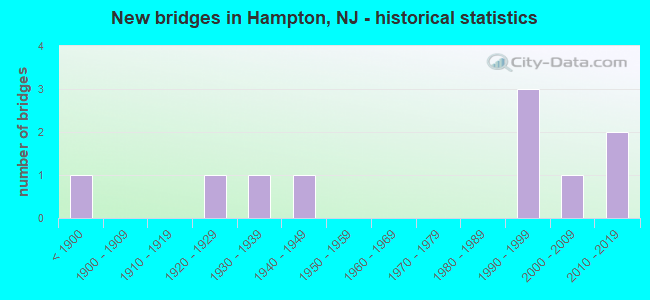
- New bridges - historical statistics
- 1Before 1900
- 11920-1929
- 11930-1939
- 11940-1949
- 31990-1999
- 12000-2009
- 22010-2019

- Reconstructed bridges - Historical Statistics
- 11970-1979
- 21980-1989
- 01990-1999
- 02000-2009
- 12010-2019


- Bridge Condition - Deck
- 12.5%Very good
- 25.0%Good
- 50.0%Satisfactory
- 12.5%Fair

- Bridge Condition - Superstructure
- 37.5%Very good
- 12.5%Good
- 25.0%Satisfactory
- 12.5%Fair
- 12.5%Imminent failure

- Bridge Condition - Substructure
- 12.5%Very good
- 37.5%Good
- 12.5%Satisfactory
- 37.5%Fair

- Bridge Condition - Channel
- 22.2%Very good
- 22.2%Good
- 44.4%Satisfactory
- 11.1%Fair

- Bridge Condition - Culverts
- 50.0%Good
- 50.0%Satisfactory
Find on map >> Show street view
Structure Number: 1013151, Location: 1.23 MI N OF I-78 JCT (Lat: 40.644081, Lng: -74.908639), Route carried "on" structure: State highway 31, Year Built: 1996, Status: Open, Structure Length: 7.77m (25.49ft), Average Daily Traffic: 30,564 (year 2020), Truck Traffic: 4%, Average Future Daily Traffic: 36,677 (year 2040), Design Load: HS 25 or greater, Features Intersected: S BRANCH RARITAN RIVER
Minimum Vertical Clearance: 30+ m (98+ ft), Kilometerpoint: 53.318, Lanes on structure: 4, Base Highway Network: Yes, Owner: State Highway Agency, Approaching Roadway Width: 27.6m (90.6ft), Skew: 31 degrees, Material/Design: Prestressed concrete, Design/Construction: Stringer/Multi-beam, Number Of Spans In Main Unit: 2, Length of Maximum Span: 38.1m (125.0ft), Curb or Sidewalk Widths: Left: 0.0m, Right: 1.8m (5.9ft), Curb-To-Curb Width: 27.6m (90.6ft), Out-to-Out Width: 31.0m (101.7ft)
Condition: Deck: Good, Superstructure: Very good, Substructure: Good, Channel: Very good, Inventory Rating: 44.5 metric tons, Method Used To Determine Inventory Rating: Load Factor (LF), Structural Evaluation: Better than present minimum criteria, Deck Geometry: Superior to present desirable criteria, Waterway Adequacy: Superior to present desirable criteria, Approach Roadway Alignment: Equal to present minimum criteria, Designated Inspection Frequency: Every 24 months, Inspection Date: July 2020, Deck Structure Type: Concrete Cast-file-Place, Wearing Surface/Protective System: Wearing Surface: Latex Concrete, Deck Protection: Epoxy Coated Reinforcing
Find on map >> Show street view
Structure Number: 1013158, Location: 0.3 MI N OF MAIN Street (Lat: 40.709619, Lng: -74.950250), Route carried "on" structure: State highway 31, Year Built: 2013, Status: Open, Structure Length: 2.80m (9.19ft), Average Daily Traffic: 21,437 (year 2020), Truck Traffic: 4%, Average Future Daily Traffic: 25,725 (year 2040), Design Load: HL 93, Features Intersected: RARITAN VALLEY LINE
Minimum Vertical Clearance: 30+ m (98+ ft), Kilometerpoint: 61.815, Lanes on structure: 3, Base Highway Network: Yes, Owner: State Highway Agency, Approaching Roadway Width: 20.7m (67.9ft), Skew: 4 degrees, Material/Design: Steel, Design/Construction: Stringer/Multi-beam, Number Of Spans In Main Unit: 1, Length of Maximum Span: 26.8m (87.9ft), Curb or Sidewalk Widths: Left: 1.8m (5.9ft), Right: 0.0m, Curb-To-Curb Width: 20.7m (67.9ft), Out-to-Out Width: 23.5m (77.1ft)
Condition: Deck: Good, Superstructure: Very good, Substructure: Very good, Operating Rating: 41.5 metric tons, Method Used To Determine Operating Rating: Load and Resistance Factor Rating (LRFR) rating reported by rating factor(RF) method using HL-93 loadings, Inventory Rating: 33.0 metric tons, Method Used To Determine Inventory Rating: Load and Resistance Factor Rating (LRFR) rating reported by rating factor(RF) method using HL-93 loadings, Structural Evaluation: Equal to present desirable criteria, Deck Geometry: Superior to present desirable criteria, Underclear: Equal to present desirable criteria, Approach Roadway Alignment: Equal to present desirable criteria, Designated Inspection Frequency: Every 24 months, Inspection Date: September 2020, Deck Structure Type: Concrete Cast-file-Place, Wearing Surface/Protective System: Deck Protection: Epoxy Coated Reinforcing
Find on map >> Show street view
Structure Number: 1013159, Location: 0.75 MI SO OF CR 632 (Lat: 40.711481, Lng: -74.967769), Route carried "on" structure: State highway 31, Year Built: 1931, Year Reconstructed: 1978, Status: Open, Structure Length: 5.12m (16.80ft), Average Daily Traffic: 22,555 (year 2021), Truck Traffic: 4%, Average Future Daily Traffic: 27,066 (year 2041), Design Load: HS 20, Features Intersected: MUSCONETCONG RIVER
Minimum Vertical Clearance: 30+ m (98+ ft), Kilometerpoint: 63.456, Lanes on structure: 3, Base Highway Network: Yes, Owner: State Highway Agency, Approaching Roadway Width: 12.5m (41.0ft), Skew: 3 degrees, Material/Design: Steel, Design/Construction: Stringer/Multi-beam, Number Of Spans In Main Unit: 3, Length of Maximum Span: 16.2m (53.1ft), Curb or Sidewalk Widths: Left: 0.0m, Right: 1.8m (5.9ft), Curb-To-Curb Width: 12.6m (41.3ft), Out-to-Out Width: 15.2m (49.9ft)
Condition: Deck: Satisfactory, Superstructure: Satisfactory, Substructure: Fair, Channel: Satisfactory, Operating Rating: 68.0 metric tons, Method Used To Determine Operating Rating: Load Factor (LF), Inventory Rating: 40.8 metric tons, Method Used To Determine Inventory Rating: Load Factor (LF), Structural Evaluation: Somewhat better than minimum adequacy, Deck Geometry: Meets minimum limits, Waterway Adequacy: Equal to present desirable criteria, Approach Roadway Alignment: Equal to present desirable criteria, Designated Inspection Frequency: Every 24 months, Inspection Date: June 2021, Deck Structure Type: Concrete Cast-file-Place, Wearing Surface/Protective System: Wearing Surface: Monolithic Concrete
Find on map >> Show street view
Structure Number: 10XXB26, Location: 1.4 MI WEST OF NJ 31 (Lat: 40.704239, Lng: -74.987319), Route carried "on" structure: City street , Year Built: 2010, Status: Open, Structure Length: 3.20m (10.50ft), Average Daily Traffic: 673 (year 2021), Truck Traffic: 3%, Average Future Daily Traffic: 822 (year 2041), Design Load: HS 25 or greater, Features Intersected: MUSCONETCONG RIVER, Facility Carried by Structure: VALLEY ROAD
Minimum Vertical Clearance: 30+ m (98+ ft), Kilometerpoint: 0.000, Lanes on structure: 2, Owner: County Highway Agency, Approaching Roadway Width: 7.9m (25.9ft), Skew: 1 degrees, Material/Design: Steel, Design/Construction: Stringer/Multi-beam, Number Of Spans In Main Unit: 2, Length of Maximum Span: 15.2m (49.9ft), Curb-To-Curb Width: 7.9m (25.9ft), Out-to-Out Width: 8.7m (28.5ft)
Condition: Deck: Very good, Superstructure: Very good, Substructure: Good, Channel: Good, Inventory Rating: 84.4 metric tons, Method Used To Determine Inventory Rating: Load Factor (LF), Structural Evaluation: Better than present minimum criteria, Deck Geometry: Somewhat better than minimum adequacy, Waterway Adequacy: Better than present minimum criteria, Approach Roadway Alignment: Better than present minimum criteria, Designated Inspection Frequency: Every 24 months, Inspection Date: May 2021, Deck Structure Type: Concrete Cast-file-Place, Wearing Surface/Protective System: Wearing Surface: Monolithic Concrete, Deck Protection: Epoxy Coated Reinforcing
Find on map >> Show street view
Structure Number: 210058, Location: MapleAve & ShurtsRd JCT (Lat: 40.705261, Lng: -74.989089), Route carried "on" structure: City street , Year Built: 1923, Year Reconstructed: 1993, Status: Open, Structure Length: 0.79m (2.59ft), Average Daily Traffic: 1,235 (year 2021), Truck Traffic: 3%, Average Future Daily Traffic: 1,480 (year 2041), Design Load: HS 20, Features Intersected: TRIB MUSCONETCONG RIVER, Facility Carried by Structure: MAPLE AVE
Minimum Vertical Clearance: 30+ m (98+ ft), Kilometerpoint: 0.000, Lanes on structure: 2, Owner: County Highway Agency, Approaching Roadway Width: 8.2m (26.9ft), Material/Design: Wood or Timber, Design/Construction: Slab, Number Of Spans In Main Unit: 1, Length of Maximum Span: 6.4m (21.0ft), Curb-To-Curb Width: 8.4m (27.6ft), Out-to-Out Width: 8.7m (28.5ft)
Condition: Deck: Satisfactory, Superstructure: Satisfactory, Substructure: Satisfactory, Channel: Satisfactory, Operating Rating: 62.6 metric tons, Method Used To Determine Operating Rating: Allowable Stress (AS), Inventory Rating: 42.6 metric tons, Method Used To Determine Inventory Rating: Allowable Stress (AS), Structural Evaluation: Equal to present minimum criteria, Deck Geometry: Meets minimum limits, Waterway Adequacy: Better than present minimum criteria, Approach Roadway Alignment: Equal to present minimum criteria, Designated Inspection Frequency: Every 24 months, Inspection Date: March 2021, Deck Structure Type: Wood or Timber, Wearing Surface/Protective System: Wearing Surface: Bituminous
Find on map >> Show street view
Structure Number: 2100581, Location: 0.4 MI SO OF CR 632 JCT (Lat: 40.710289, Lng: -74.990011), Route carried "on" structure: City street , Year Built: 1991, Status: Open, Structure Length: 1.25m (4.10ft), Average Daily Traffic: 1,230 (year 2021), Truck Traffic: 5%, Average Future Daily Traffic: 1,480 (year 2041), Design Load: HS 20+Mod, Features Intersected: TRIB MUSCONETCONG RIVER, Facility Carried by Structure: SHURTS RD
Minimum Vertical Clearance: 30+ m (98+ ft), Kilometerpoint: 0.000, Lanes on structure: 2, Owner: County Highway Agency, Approaching Roadway Width: 7.3m (24.0ft), Skew: 5 degrees, Material/Design: Aluminum, Iron, Design/Construction: Culvert, Number Of Spans In Main Unit: 1, Length of Maximum Span: 12.5m (41.0ft)
Condition: Channel: Fair, Culverts: Good, Operating Rating: 68.0 metric tons, Method Used To Determine Operating Rating: Load Factor (LF), Inventory Rating: 40.8 metric tons, Method Used To Determine Inventory Rating: Load Factor (LF), Structural Evaluation: Better than present minimum criteria, Waterway Adequacy: Better than present minimum criteria, Approach Roadway Alignment: Equal to present minimum criteria, Designated Inspection Frequency: Every 24 months, Inspection Date: April 2021
Find on map >> Show street view
Structure Number: 2102223, Location: 1.09 MI E OF RT NJ 31 JCT (Lat: 40.734869, Lng: -74.960581), Route carried "on" structure: County highway 632, Year Built: 1942, Year Reconstructed: 2010, Status: Open, Structure Length: 1.28m (4.20ft), Average Daily Traffic: 4,588 (year 2021), Truck Traffic: 4%, Average Future Daily Traffic: 5,598 (year 2041), Features Intersected: TRIB TO MUSCONETCONG RIV
Minimum Vertical Clearance: 30+ m (98+ ft), Kilometerpoint: 13.728, Lanes on structure: 2, Owner: County Highway Agency, Approaching Roadway Width: 10.1m (33.1ft), Skew: 2 degrees, Material/Design: Concrete continuous, Design/Construction: Slab, Number Of Spans In Main Unit: 2, Length of Maximum Span: 5.8m (19.0ft), Curb-To-Curb Width: 10.2m (33.5ft), Out-to-Out Width: 11.0m (36.1ft)
Condition: Deck: Fair, Superstructure: Fair, Substructure: Fair, Channel: Good, Operating Rating: 31.8 metric tons, Method Used To Determine Operating Rating: Load Factor (LF), Inventory Rating: 19.1 metric tons, Method Used To Determine Inventory Rating: Load Factor (LF), Structural Evaluation: Somewhat better than minimum adequacy, Deck Geometry: Meets minimum limits, Waterway Adequacy: Equal to present minimum criteria, Approach Roadway Alignment: Meets minimum limits, Designated Inspection Frequency: Every 24 months, Inspection Date: March 2021, Deck Structure Type: Concrete Cast-file-Place, Wearing Surface/Protective System: Wearing Surface: Bituminous, Membrane: Preformed Fabric
Find on map >> Show street view
Structure Number: 2102224, Location: 120 FT WEST OF CO RT 645 (Lat: 40.723169, Lng: -74.960100), Route carried "on" structure: City street , Year Built: 2007, Status: Open, Structure Length: 2.83m (9.28ft), Average Daily Traffic: 380 (year 2021), Truck Traffic: 1%, Average Future Daily Traffic: 460 (year 2041), Design Load: HS 25 or greater, Features Intersected: MUSCONETCONG RIVER, Facility Carried by Structure: NEW HAMPTON ROAD
Minimum Vertical Clearance: 30+ m (98+ ft), Kilometerpoint: 0.000, Lanes on structure: 2, Owner: County Highway Agency, Approaching Roadway Width: 6.1m (20.0ft), Material/Design: Steel, Design/Construction: Truss - Thru, Number Of Spans In Main Unit: 1, Length of Maximum Span: 26.8m (87.9ft), Curb-To-Curb Width: 7.3m (24.0ft), Out-to-Out Width: 7.6m (24.9ft)
Condition: Deck: Satisfactory, Superstructure: Good, Substructure: Good, Channel: Satisfactory, Operating Rating: 56.2 metric tons, Method Used To Determine Operating Rating: Load Factor (LF), Inventory Rating: 33.6 metric tons, Method Used To Determine Inventory Rating: Load Factor (LF), Structural Evaluation: Better than present minimum criteria, Deck Geometry: Somewhat better than minimum adequacy, Waterway Adequacy: Better than present minimum criteria, Approach Roadway Alignment: Meets minimum limits, Designated Inspection Frequency: Every 24 months, Critical Feature Inspection Frequency: Every 24 months, Inspection Date: March 2021, Critical Feature Inspection Date: March 2021, Deck Structure Type: Corrugated Steel, Wearing Surface/Protective System: Wearing Surface: Bituminous, Membrane: Preformed Fabric
Find on map >> Show street view
Structure Number: 2102225, Location: 0.1 MILE NO OF CR 645 JCT (Lat: 40.720550, Lng: -74.963669), Route carried "on" structure: City street , Year Built: 1868, Year Reconstructed: 1991, Status: Closed, Structure Length: 2.59m (8.50ft), Average Daily Traffic: 410 (year 2019), Average Future Daily Traffic: 550 (year 2039), Features Intersected: MUSCONETCONG RIVER, Facility Carried by Structure: RYMON ROAD
Minimum Vertical Clearance: 30+ m (98+ ft), Kilometerpoint: 0.000, Lanes on structure: 1, Owner: County Highway Agency, Approaching Roadway Width: 5.8m (19.0ft), Material/Design: Aluminum, Iron, Design/Construction: Truss - Thru, Number Of Spans In Main Unit: 1, Length of Maximum Span: 24.4m (80.1ft), Curb-To-Curb Width: 4.9m (16.1ft), Out-to-Out Width: 5.2m (17.1ft)
Condition: Deck: Satisfactory, Superstructure: Imminent failure, Substructure: Fair, Channel: Satisfactory, Waterway Adequacy: Equal to present minimum criteria, Approach Roadway Alignment: High priority of corrective action, Bridge Posting: Required (Relationship of Operating Rating to Maximum Legal Load: > 39.9% below), Length Of Structure Improvement: 3.66m (12.01ft), Designated Inspection Frequency: Every 24 months, Critical Feature Inspection Frequency: Every 24 months, Other Special Inspection Frequency: Every 12 months, Inspection Date: April 2019, Critical Feature Inspection Date: April 2019, Other Special Inspection Date: April 2019, Bridge Improvement Cost: $1,530,000, Roadway Improvement Cost: $50,000, Total Project Cost: $2,261,000 ( Estimate for 2019), Deck Structure Type: Wood or Timber, Wearing Surface/Protective System: Wearing Surface: Bituminous
Find on map >> Show street view
Structure Number: 2102237, Location: 1.14 MI W OF RT 31 (Lat: 40.715061, Lng: -74.990761), Route carried "on" structure: County highway 632, Year Built: 1997, Status: Open, Structure Length: 0.79m (2.59ft), Average Daily Traffic: 4,877 (year 2021), Truck Traffic: 3%, Average Future Daily Traffic: 5,951 (year 2041), Design Load: HS 20+Mod, Features Intersected: TRIB MUSCONETCONG RIVER
Minimum Vertical Clearance: 30+ m (98+ ft), Kilometerpoint: 10.171, Lanes on structure: 2, Owner: County Highway Agency, Approaching Roadway Width: 12.2m (40.0ft), Skew: 1 degrees, Material/Design: Concrete, Design/Construction: Culvert, Number Of Spans In Main Unit: 2, Length of Maximum Span: 3.7m (12.1ft)
Condition: Channel: Very good, Culverts: Satisfactory, Operating Rating: 86.2 metric tons, Method Used To Determine Operating Rating: Load Factor (LF), Inventory Rating: 51.7 metric tons, Method Used To Determine Inventory Rating: Load Factor (LF), Structural Evaluation: Equal to present minimum criteria, Waterway Adequacy: Equal to present desirable criteria, Approach Roadway Alignment: Equal to present desirable criteria, Designated Inspection Frequency: Every 24 months, Inspection Date: March 2021