Bridge Statistics for Hanover, Kansas (KS)
Condition, Traffic, Stress, Structural Evaluation, Project Costs
- National Bridge Inventory (NBI) Statistics
- 19Number of bridges
- 167ft / 50.8mTotal length
- $940,000Total costs
- 13,825Total average daily traffic
- 2,366Total average daily truck traffic
- 17,199Total future (year 2038) average daily traffic
- National Bridge Inventory (NBI) Registered Bridges for Hanover
- No street view available for this location
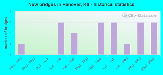
- New bridges - historical statistics
- 11900-1909
- 31930-1939
- 21940-1949
- 31960-1969
- 31970-1979
- 11980-1989
- 31990-1999
- 32000-2009

- Reconstructed bridges - Historical Statistics
- 21960-1969
- 01970-1979
- 01980-1989
- 21990-1999

- Bridge Condition - Deck
- 8.3%Very good
- 58.3%Good
- 16.7%Satisfactory
- 8.3%Fair
- 8.3%Poor

- Bridge Condition - Superstructure
- 25.0%Very good
- 33.3%Good
- 33.3%Satisfactory
- 8.3%Poor

- Bridge Condition - Substructure
- 16.7%Very good
- 25.0%Good
- 41.7%Satisfactory
- 8.3%Fair
- 8.3%Poor

- Bridge Condition - Channel
- 11.1%Very good
- 33.3%Good
- 55.6%Satisfactory

- Bridge Condition - Culverts
- 71.4%Good
- 28.6%Satisfactory
Find on map >> Show street view
Structure Number: 101023, Location: 4.5N 0.4E OF HANOVER (Lat: 39.958453, Lng: -96.865456), Route carried "on" structure: County highway 622, Year Built: 2000, Status: Open, Structure Length: 3.00m (9.84ft), Average Daily Traffic: 75 (year 2014), Average Future Daily Traffic: 90 (year 2039), Design Load: HS 20, Features Intersected: HORSESHOE CREEK
Minimum Vertical Clearance: 30.47m (99.97ft), Kilometerpoint: 0.000, Lanes on structure: 2, Owner: County Highway Agency, Approaching Roadway Width: 8.0m (26.2ft), Material/Design: Concrete continuous, Design/Construction: Slab, Number Of Spans In Main Unit: 3, Length of Maximum Span: 12.0m (39.4ft), Curb-To-Curb Width: 8.6m (28.2ft), Out-to-Out Width: 9.2m (30.2ft)
Condition: Deck: Very good, Superstructure: Very good, Substructure: Very good, Channel: Good, Operating Rating: 81.7 metric tons, Method Used To Determine Operating Rating: Load Factor (LF), Inventory Rating: 49.0 metric tons, Method Used To Determine Inventory Rating: Load Factor (LF), Structural Evaluation: Equal to present desirable criteria, Deck Geometry: Better than present minimum criteria, Waterway Adequacy: Better than present minimum criteria, Approach Roadway Alignment: Equal to present desirable criteria, Designated Inspection Frequency: Every 24 months, Inspection Date: Febuary 2021, Deck Structure Type: Concrete Cast-file-Place
Find on map >> Show street view
Structure Number: 101051, Location: NORTH STREET IN HANOVER (Lat: 39.892831, Lng: -96.879692), Route carried "on" structure: County highway 1100, Year Built: 2001, Status: Open, Structure Length: 0.66m (2.17ft), Average Daily Traffic: 240 (year 2014), Average Future Daily Traffic: 288 (year 2039), Design Load: HS 20, Features Intersected: TRIB. TO LITTLE BLUE RV.
Minimum Vertical Clearance: 30.47m (99.97ft), Kilometerpoint: 0.000, Lanes on structure: 2, Owner: County Highway Agency, Approaching Roadway Width: 18.5m (60.7ft), Skew: 3 degrees, Material/Design: Concrete, Design/Construction: Culvert, Number Of Spans In Main Unit: 2, Length of Maximum Span: 3.1m (10.2ft), Curb-To-Curb Width: 39.0m (128.0ft), Out-to-Out Width: 39.0m (128.0ft)
Condition: Channel: Very good, Culverts: Good, Operating Rating: 70.9 metric tons, Method Used To Determine Operating Rating: Load Factor (LF), Inventory Rating: 42.5 metric tons, Method Used To Determine Inventory Rating: Load Factor (LF), Structural Evaluation: Better than present minimum criteria, Deck Geometry: Superior to present desirable criteria, Waterway Adequacy: Equal to present minimum criteria, Approach Roadway Alignment: Equal to present desirable criteria, Designated Inspection Frequency: Every 24 months, Inspection Date: Febuary 2021, Deck Structure Type: Concrete Cast-file-Place
Find on map >> Show street view
Structure Number: 101067, Location: 0.5N 1.7E OF HANOVER (Lat: 39.900039, Lng: -96.840611), Route carried "on" structure: County highway 1107, Year Built: 1971, Status: Posted for load, Structure Length: 0.79m (2.59ft), Average Daily Traffic: 215 (year 2014), Average Future Daily Traffic: 258 (year 2039), Design Load: H 20, Features Intersected: COTTONWOOD CREEK
Minimum Vertical Clearance: 30.47m (99.97ft), Kilometerpoint: 0.000, Lanes on structure: 2, Owner: County Highway Agency, Approaching Roadway Width: 9.1m (29.9ft), Material/Design: Concrete, Design/Construction: Culvert, Number Of Spans In Main Unit: 2, Length of Maximum Span: 3.7m (12.1ft), Curb-To-Curb Width: 9.4m (30.8ft), Out-to-Out Width: 12.2m (40.0ft)
Condition: Channel: Satisfactory, Culverts: Good, Operating Rating: 60.4 metric tons, Method Used To Determine Operating Rating: Load Factor (LF), Inventory Rating: 36.1 metric tons, Method Used To Determine Inventory Rating: Load Factor (LF), Structural Evaluation: Better than present minimum criteria, Deck Geometry: Equal to present minimum criteria, Waterway Adequacy: Better than present minimum criteria, Approach Roadway Alignment: Equal to present desirable criteria, Designated Inspection Frequency: Every 24 months, Inspection Date: Febuary 2021
Find on map >> Show street view
Structure Number: 101076, Location: 1.9N 3.5W OF HANOVER (Lat: 39.921022, Lng: -96.937206), Route carried "on" structure: County highway 1493, Year Built: 1967, Status: Posted for load, Structure Length: 5.49m (18.01ft), Average Daily Traffic: 95 (year 2014), Truck Traffic: 10%, Average Future Daily Traffic: 114 (year 2039), Design Load: H 15, Features Intersected: MILL CREEK
Minimum Vertical Clearance: 30.47m (99.97ft), Kilometerpoint: 0.000, Lanes on structure: 2, Owner: County Highway Agency, Approaching Roadway Width: 9.1m (29.9ft), Material/Design: Steel continuous, Design/Construction: Stringer/Multi-beam, Number Of Spans In Main Unit: 5, Length of Maximum Span: 14.9m (48.9ft), Curb-To-Curb Width: 7.3m (24.0ft), Out-to-Out Width: 8.5m (27.9ft)
Condition: Deck: Good, Superstructure: Good, Substructure: Satisfactory, Channel: Satisfactory, Operating Rating: 26.4 metric tons, Method Used To Determine Operating Rating: Load Factor (LF), Inventory Rating: 16.1 metric tons, Method Used To Determine Inventory Rating: Load Factor (LF), Structural Evaluation: Meets minimum limits, Deck Geometry: Equal to present minimum criteria, Waterway Adequacy: Equal to present desirable criteria, Approach Roadway Alignment: Equal to present desirable criteria, Designated Inspection Frequency: Every 24 months, Inspection Date: Febuary 2021, Deck Structure Type: Concrete Cast-file-Place
Find on map >> Show street view
Structure Number: 1010865503184, Location: 1.8W 2.0S OF HANOVER (Lat: 39.864989, Lng: -96.909269), Route carried "on" structure: County highway 10133, Year Built: 1965, Status: Posted for load, Structure Length: 0.73m (2.40ft), Average Daily Traffic: 50 (year 2014), Average Future Daily Traffic: 60 (year 2039), Features Intersected: ZEKA CREEK, Facility Carried by Structure: Y.5-10.4 130
Minimum Vertical Clearance: 30.47m (99.97ft), Kilometerpoint: 0.000, Lanes on structure: 2, Owner: County Highway Agency, Approaching Roadway Width: 7.3m (24.0ft), Material/Design: Steel, Design/Construction: Stringer/Multi-beam, Number Of Spans In Main Unit: 1, Length of Maximum Span: 7.0m (23.0ft), Curb-To-Curb Width: 6.1m (20.0ft), Out-to-Out Width: 6.1m (20.0ft)
Condition: Deck: Satisfactory, Superstructure: Satisfactory, Substructure: Satisfactory, Channel: Satisfactory, Operating Rating: 20.6 metric tons, Method Used To Determine Operating Rating: Load Factor (LF), Inventory Rating: 12.3 metric tons, Method Used To Determine Inventory Rating: Load Factor (LF), Structural Evaluation: Meets minimum limits, Deck Geometry: Somewhat better than minimum adequacy, Waterway Adequacy: Equal to present minimum criteria, Approach Roadway Alignment: Equal to present desirable criteria, Bridge Posting: Required (Relationship of Operating Rating to Maximum Legal Load: > 39.9% below), Designated Inspection Frequency: Every 24 months, Inspection Date: March 2021, Deck Structure Type: Corrugated Steel, Wearing Surface/Protective System: Wearing Surface: Gravel
Find on map >> Show street view
Structure Number: 101086780308, Location: 0.5W 3.5N OF HANOVER (Lat: 39.943889, Lng: -96.884933), Route carried "on" structure: County highway , Year Built: 1976, Status: Posted for load, Structure Length: 3.08m (10.10ft), Average Daily Traffic: 15 (year 2014), Average Future Daily Traffic: 20 (year 2038), Features Intersected: ABANDON BN RAILROAD, Facility Carried by Structure: 5-Z.8 186
Minimum Vertical Clearance: 30.47m (99.97ft), Kilometerpoint: 0.000, Lanes on structure: 2, Owner: County Highway Agency, Approaching Roadway Width: 8.5m (27.9ft), Material/Design: Wood or Timber, Design/Construction: Stringer/Multi-beam, Number Of Spans In Main Unit: 5, Length of Maximum Span: 7.6m (24.9ft), Curb-To-Curb Width: 7.9m (25.9ft), Out-to-Out Width: 8.5m (27.9ft)
Condition: Deck: Satisfactory, Superstructure: Satisfactory, Substructure: Satisfactory, Operating Rating: 25.3 metric tons, Method Used To Determine Operating Rating: Allowable Stress (AS), Inventory Rating: 18.1 metric tons, Method Used To Determine Inventory Rating: Allowable Stress (AS), Structural Evaluation: Somewhat better than minimum adequacy, Deck Geometry: Equal to present minimum criteria, Underclear: High priority of replacement, Approach Roadway Alignment: Somewhat better than minimum adequacy, Bridge Posting: Required (Relationship of Operating Rating to Maximum Legal Load: 0.1 - 9.9% below), Length Of Structure Improvement: 3.35m (10.99ft), Designated Inspection Frequency: Every 24 months, Inspection Date: Febuary 2021, Bridge Improvement Cost: $290,000, Roadway Improvement Cost: $11,000, Total Project Cost: $400,000 ( Estimate for 2015), Deck Structure Type: Wood or Timber, Wearing Surface/Protective System: Wearing Surface: Wood or Timber
Find on map >> Show street view
Structure Number: 101086790318, Location: 0.4W 1.6S OF HANOVER (Lat: 39.870925, Lng: -96.882572), Route carried "on" structure: County highway , Year Built: 1965, Status: Posted for load, Structure Length: 0.91m (2.99ft), Average Daily Traffic: 35 (year 2014), Average Future Daily Traffic: 42 (year 2039), Features Intersected: COTTONWOOD CREEK, Facility Carried by Structure: 10-Z.8 131
Minimum Vertical Clearance: 30.47m (99.97ft), Kilometerpoint: 0.000, Lanes on structure: 2, Owner: County Highway Agency, Approaching Roadway Width: 7.3m (24.0ft), Material/Design: Steel, Design/Construction: Stringer/Multi-beam, Number Of Spans In Main Unit: 1, Length of Maximum Span: 8.8m (28.9ft), Curb-To-Curb Width: 6.4m (21.0ft), Out-to-Out Width: 6.7m (22.0ft)
Condition: Deck: Fair, Superstructure: Satisfactory, Substructure: Satisfactory, Channel: Satisfactory, Operating Rating: 16.1 metric tons, Method Used To Determine Operating Rating: Load Factor (LF), Inventory Rating: 9.6 metric tons, Method Used To Determine Inventory Rating: Load Factor (LF), Structural Evaluation: High priority of replacement, Deck Geometry: Somewhat better than minimum adequacy, Waterway Adequacy: Equal to present minimum criteria, Approach Roadway Alignment: Equal to present desirable criteria, Bridge Posting: Required (Relationship of Operating Rating to Maximum Legal Load: > 39.9% below), Length Of Structure Improvement: 2.15m (7.05ft), Designated Inspection Frequency: Every 24 months, Inspection Date: March 2021, Bridge Improvement Cost: $190,000, Roadway Improvement Cost: $110,000, Total Project Cost: $300,000 ( Estimate for 2015), Deck Structure Type: Corrugated Steel, Wearing Surface/Protective System: Wearing Surface: Gravel
Find on map >> Show street view
Structure Number: 1010869003164, Location: 0.9S 0.2W OF HANOVER (Lat: 39.879578, Lng: -96.880764), Route carried "on" structure: County highway , Year Built: 1930, Year Reconstructed: 2002, Status: Open, Structure Length: 1.22m (4.00ft), Average Daily Traffic: 50 (year 2014), Average Future Daily Traffic: 60 (year 2039), Design Load: HS 20, Features Intersected: COTTONWOOD CREEK, Facility Carried by Structure: AA-9.4 132
Minimum Vertical Clearance: 30.47m (99.97ft), Kilometerpoint: 0.000, Lanes on structure: 2, Owner: County Highway Agency, Approaching Roadway Width: 7.4m (24.3ft), Material/Design: Steel, Design/Construction: Stringer/Multi-beam, Number Of Spans In Main Unit: 1, Length of Maximum Span: 12.2m (40.0ft), Curb-To-Curb Width: 7.9m (25.9ft), Out-to-Out Width: 8.1m (26.6ft)
Condition: Deck: Good, Superstructure: Good, Substructure: Satisfactory, Channel: Satisfactory, Operating Rating: 72.1 metric tons, Method Used To Determine Operating Rating: Allowable Stress (AS), Inventory Rating: 50.2 metric tons, Method Used To Determine Inventory Rating: Allowable Stress (AS), Structural Evaluation: Equal to present minimum criteria, Deck Geometry: Equal to present minimum criteria, Waterway Adequacy: Equal to present minimum criteria, Approach Roadway Alignment: Equal to present desirable criteria, Designated Inspection Frequency: Every 24 months, Inspection Date: Febuary 2021, Deck Structure Type: Corrugated Steel, Wearing Surface/Protective System: Wearing Surface: Monolithic Concrete
Find on map >> Show street view
Structure Number: 1010869103146, Location: HANOVER (Lat: 39.891550, Lng: -96.879747), Route carried "on" structure: County highway , Year Built: 1940, Status: Posted for load, Structure Length: 1.01m (3.31ft), Average Daily Traffic: 40 (year 2014), Average Future Daily Traffic: 48 (year 2039), Features Intersected: TRIB TO LITTLE BLUE RV, Facility Carried by Structure: 8.6-AA.1 335
Minimum Vertical Clearance: 30.47m (99.97ft), Kilometerpoint: 0.000, Lanes on structure: 2, Owner: County Highway Agency, Approaching Roadway Width: 11.9m (39.0ft), Skew: 4 degrees, Material/Design: Wood or Timber, Design/Construction: Stringer/Multi-beam, Number Of Spans In Main Unit: 2, Length of Maximum Span: 5.2m (17.1ft), Curb-To-Curb Width: 12.0m (39.4ft), Out-to-Out Width: 12.1m (39.7ft)
Condition: Deck: Poor, Superstructure: Poor, Substructure: Poor, Channel: Satisfactory, Operating Rating: 19.9 metric tons, Method Used To Determine Operating Rating: Allowable Stress (AS), Inventory Rating: 15.0 metric tons, Method Used To Determine Inventory Rating: Allowable Stress (AS), Structural Evaluation: Meets minimum limits, Deck Geometry: Superior to present desirable criteria, Waterway Adequacy: Somewhat better than minimum adequacy, Approach Roadway Alignment: Equal to present desirable criteria, Bridge Posting: Required (Relationship of Operating Rating to Maximum Legal Load: 10.0 - 19.9% below), Length Of Structure Improvement: 1.52m (4.99ft), Designated Inspection Frequency: Every 24 months, Inspection Date: Febuary 2021, Bridge Improvement Cost: $130,000, Roadway Improvement Cost: $110,000, Total Project Cost: $240,000 ( Estimate for 2015), Deck Structure Type: Wood or Timber, Wearing Surface/Protective System: Wearing Surface: Wood or Timber
Find on map >> Show street view
Structure Number: 1010869503163, Location: 0.2E 1.0S OF HANOVER (Lat: 39.879567, Lng: -96.871772), Route carried "on" structure: County highway , Year Built: 1979, Status: Posted for load, Structure Length: 1.04m (3.41ft), Average Daily Traffic: 45 (year 2014), Average Future Daily Traffic: 54 (year 2039), Design Load: H 20, Features Intersected: COTTONWOOD CREEK, Facility Carried by Structure: AA.5-9.3 134
Minimum Vertical Clearance: 30.47m (99.97ft), Kilometerpoint: 0.000, Lanes on structure: 2, Owner: County Highway Agency, Approaching Roadway Width: 8.5m (27.9ft), Material/Design: Concrete, Design/Construction: Culvert, Number Of Spans In Main Unit: 1, Length of Maximum Span: 10.4m (34.1ft), Curb-To-Curb Width: 7.9m (25.9ft), Out-to-Out Width: 12.2m (40.0ft)
Condition: Channel: Good, Culverts: Good, Operating Rating: 41.4 metric tons, Method Used To Determine Operating Rating: Load Factor (LF), Inventory Rating: 25.2 metric tons, Method Used To Determine Inventory Rating: Load Factor (LF), Structural Evaluation: Equal to present minimum criteria, Deck Geometry: Equal to present minimum criteria, Waterway Adequacy: Better than present minimum criteria, Approach Roadway Alignment: Equal to present desirable criteria, Designated Inspection Frequency: Every 24 months, Inspection Date: Febuary 2021
Find on map >> Show street view
Structure Number: 1010869503187, Location: 2.2S OF HANOVER (Lat: 39.861331, Lng: -96.873072), Route carried "on" structure: County highway , Year Built: 1900, Year Reconstructed: 1960, Status: Open, Structure Length: 1.16m (3.81ft), Average Daily Traffic: 45 (year 2014), Average Future Daily Traffic: 54 (year 2039), Features Intersected: CEDAR CREEK, Facility Carried by Structure: AA.5-10.7 133
Minimum Vertical Clearance: 30.47m (99.97ft), Kilometerpoint: 0.000, Lanes on structure: 2, Owner: County Highway Agency, Approaching Roadway Width: 6.7m (22.0ft), Material/Design: Steel, Design/Construction: Stringer/Multi-beam, Number Of Spans In Main Unit: 1, Length of Maximum Span: 11.0m (36.1ft), Curb-To-Curb Width: 6.4m (21.0ft), Out-to-Out Width: 6.6m (21.7ft)
Condition: Deck: Good, Superstructure: Satisfactory, Substructure: Fair, Channel: Satisfactory, Operating Rating: 40.5 metric tons, Method Used To Determine Operating Rating: Allowable Stress (AS), Inventory Rating: 24.3 metric tons, Method Used To Determine Inventory Rating: Allowable Stress (AS), Structural Evaluation: Somewhat better than minimum adequacy, Deck Geometry: Somewhat better than minimum adequacy, Waterway Adequacy: Equal to present minimum criteria, Approach Roadway Alignment: Equal to present desirable criteria, Designated Inspection Frequency: Every 24 months, Inspection Date: Febuary 2021, Deck Structure Type: Corrugated Steel, Wearing Surface/Protective System: Wearing Surface: Bituminous
Find on map >> Show street view
Structure Number: 1010873003069, Location: 3.7N 1.8E OF HANOVER (Lat: 39.944911, Lng: -96.843053), Route carried "on" structure: County highway , Year Built: 1991, Status: Posted for load, Structure Length: 1.71m (5.61ft), Average Daily Traffic: 40 (year 2014), Average Future Daily Traffic: 48 (year 2039), Features Intersected: HORSESHOE CREEK, Facility Carried by Structure: CC-4.9 49
Minimum Vertical Clearance: 30.47m (99.97ft), Kilometerpoint: 0.000, Lanes on structure: 2, Owner: County Highway Agency, Approaching Roadway Width: 7.3m (24.0ft), Material/Design: Steel, Design/Construction: Stringer/Multi-beam, Number Of Spans In Main Unit: 1, Length of Maximum Span: 16.5m (54.1ft), Curb-To-Curb Width: 7.3m (24.0ft), Out-to-Out Width: 7.5m (24.6ft)
Condition: Deck: Good, Superstructure: Good, Substructure: Good, Channel: Satisfactory, Operating Rating: 43.4 metric tons, Method Used To Determine Operating Rating: Load Factor (LF), Inventory Rating: 25.9 metric tons, Method Used To Determine Inventory Rating: Load Factor (LF), Structural Evaluation: Equal to present minimum criteria, Deck Geometry: Equal to present minimum criteria, Waterway Adequacy: Better than present minimum criteria, Approach Roadway Alignment: Equal to present minimum criteria, Designated Inspection Frequency: Every 24 months, Inspection Date: Febuary 2021, Deck Structure Type: Concrete Cast-file-Place
Find on map >> Show street view
Structure Number: 999903601010091, Location: 8.61MI EEJCTK15 15W (Lat: 39.834444, Lng: -96.895556), Route carried "on" structure: US 36, Year Built: 1938, Year Reconstructed: 1999, Status: Open, Structure Length: 1.15m (3.77ft), Average Daily Traffic: 2,500 (year 2020), Truck Traffic: 22%, Average Future Daily Traffic: 2,874 (year 2041), Design Load: H 15, Features Intersected: LITTLE BLUE RIVER DRG.
Minimum Vertical Clearance: 30.47m (99.97ft), Kilometerpoint: 41.230, Lanes on structure: 2, Base Highway Network: Yes, Owner: State Highway Agency, Approaching Roadway Width: 13.4m (44.0ft), Material/Design: Concrete, Design/Construction: Culvert, Number Of Spans In Main Unit: 3, Length of Maximum Span: 3.7m (12.1ft), Curb-To-Curb Width: 13.4m (44.0ft), Out-to-Out Width: 18.1m (59.4ft)
Condition: Channel: Satisfactory, Culverts: Good, Operating Rating: 48.0 metric tons, Method Used To Determine Operating Rating: Load Factor (LF), Inventory Rating: 28.8 metric tons, Method Used To Determine Inventory Rating: Load Factor (LF), Structural Evaluation: Better than present minimum criteria, Deck Geometry: Better than present minimum criteria, Waterway Adequacy: Better than present minimum criteria, Approach Roadway Alignment: Better than present minimum criteria, Length Of Structure Improvement: 3.78m (12.40ft), Designated Inspection Frequency: Every 24 months, Inspection Date: November 2021, Deck Structure Type: Concrete Cast-file-Place, Wearing Surface/Protective System: Wearing Surface: Bituminous
Find on map >> Show street view
Structure Number: 999903601010121, Location: 9.63MI EEJCTK15 15W (Lat: 39.841944, Lng: -96.879167), Route carried "on" structure: US 36, Year Built: 1936, Year Reconstructed: 1969, Status: Open, Structure Length: 0.64m (2.10ft), Average Daily Traffic: 1,250 (year 2020), Truck Traffic: 22%, Average Future Daily Traffic: 1,437 (year 2041), Design Load: H 15, Features Intersected: HUNTRESSCREEK R DRG.
Minimum Vertical Clearance: 30.47m (99.97ft), Kilometerpoint: 42.889, Lanes on structure: 4, Base Highway Network: Yes, Owner: State Highway Agency, Approaching Roadway Width: 22.6m (74.1ft), Skew: 23 degrees, Material/Design: Concrete, Design/Construction: Culvert, Number Of Spans In Main Unit: 2, Length of Maximum Span: 2.4m (7.9ft), Curb-To-Curb Width: 24.4m (80.1ft), Out-to-Out Width: 77.7m (254.9ft)
Condition: Channel: Good, Culverts: Satisfactory, Operating Rating: 89.8 metric tons, Method Used To Determine Operating Rating: Load Factor (LF), Inventory Rating: 89.8 metric tons, Method Used To Determine Inventory Rating: Load Factor (LF), Structural Evaluation: Equal to present minimum criteria, Deck Geometry: Superior to present desirable criteria, Waterway Adequacy: Equal to present minimum criteria, Approach Roadway Alignment: Better than present minimum criteria, Length Of Structure Improvement: 2.09m (6.86ft), Designated Inspection Frequency: Every 24 months, Inspection Date: November 2021, Deck Structure Type: Concrete Cast-file-Place, Wearing Surface/Protective System: Wearing Surface: Bituminous
Find on map >> Show street view
Structure Number: 999903601010501, Location: 1.4 MI W U36/K148 JCT (Lat: 39.838889, Lng: -96.886944), Route carried "on" structure: US 36, Year Built: 1999, Status: Open, Structure Length: 19.01m (62.37ft), Average Daily Traffic: 2,500 (year 2020), Truck Traffic: 22%, Average Future Daily Traffic: 2,874 (year 2041), Design Load: HS 20, Features Intersected: LITTLE BLUE RIVER
Minimum Vertical Clearance: 30.47m (99.97ft), Kilometerpoint: 42.134, Lanes on structure: 2, Base Highway Network: Yes, Owner: State Highway Agency, Approaching Roadway Width: 13.4m (44.0ft), Material/Design: Steel continuous, Design/Construction: Stringer/Multi-beam, Number Of Spans In Main Unit: 6, Length of Maximum Span: 50.0m (164.0ft), Curb-To-Curb Width: 13.4m (44.0ft), Out-to-Out Width: 14.0m (45.9ft)
Condition: Deck: Good, Superstructure: Very good, Substructure: Good, Channel: Satisfactory, Operating Rating: 57.2 metric tons, Method Used To Determine Operating Rating: Load Factor (LF), Inventory Rating: 34.5 metric tons, Method Used To Determine Inventory Rating: Load Factor (LF), Structural Evaluation: Better than present minimum criteria, Deck Geometry: Better than present minimum criteria, Waterway Adequacy: Better than present minimum criteria, Approach Roadway Alignment: Meets minimum limits, Length Of Structure Improvement: 62.38m (204.66ft), Designated Inspection Frequency: Every 24 months, Inspection Date: November 2021, Wearing Surface/Protective System: Wearing Surface: Monolithic Concrete, Deck Protection: Epoxy Coated Reinforcing
Find on map >> Show street view
Structure Number: 999914801010201, Location: 1.68 MI N US36 (Lat: 39.866111, Lng: -96.862222), Route carried "on" structure: State highway 148, Year Built: 1941, Status: Open, Structure Length: 1.06m (3.48ft), Average Daily Traffic: 1,865 (year 2020), Truck Traffic: 17%, Average Future Daily Traffic: 2,367 (year 2041), Design Load: H 15, Features Intersected: CEDAR CREEK
Minimum Vertical Clearance: 30.47m (99.97ft), Kilometerpoint: 61.281, Lanes on structure: 2, Owner: State Highway Agency, Approaching Roadway Width: 8.5m (27.9ft), Skew: 3 degrees, Material/Design: Concrete, Design/Construction: Culvert, Number Of Spans In Main Unit: 1, Length of Maximum Span: 9.1m (29.9ft), Curb-To-Curb Width: 9.8m (32.2ft), Out-to-Out Width: 15.9m (52.2ft)
Condition: Channel: Very good, Culverts: Satisfactory, Operating Rating: 47.2 metric tons, Method Used To Determine Operating Rating: Load Factor (LF), Inventory Rating: 28.1 metric tons, Method Used To Determine Inventory Rating: Load Factor (LF), Structural Evaluation: Equal to present minimum criteria, Deck Geometry: Somewhat better than minimum adequacy, Waterway Adequacy: Equal to present desirable criteria, Approach Roadway Alignment: Somewhat better than minimum adequacy, Length Of Structure Improvement: 3.81m (12.50ft), Designated Inspection Frequency: Every 24 months, Inspection Date: November 2021, Deck Structure Type: Concrete Cast-file-Place, Wearing Surface/Protective System: Wearing Surface: Bituminous
Find on map >> Show street view
Structure Number: 999914801010381, Location: 7.65 MI N US-36 (Lat: 39.955000, Lng: -96.862222), Route carried "on" structure: State highway 148, Year Built: 1991, Status: Open, Structure Length: 4.34m (14.24ft), Average Daily Traffic: 1,450 (year 2020), Truck Traffic: 12%, Average Future Daily Traffic: 2,072 (year 2041), Design Load: HS 20, Features Intersected: HORSESHOE CREEK
Minimum Vertical Clearance: 30.47m (99.97ft), Kilometerpoint: 71.172, Lanes on structure: 2, Owner: State Highway Agency, Approaching Roadway Width: 11.0m (36.1ft), Material/Design: Concrete continuous, Design/Construction: Slab, Number Of Spans In Main Unit: 3, Length of Maximum Span: 17.1m (56.1ft), Curb-To-Curb Width: 11.0m (36.1ft), Out-to-Out Width: 11.6m (38.1ft)
Condition: Deck: Good, Superstructure: Good, Substructure: Good, Channel: Good, Operating Rating: 78.9 metric tons, Method Used To Determine Operating Rating: Load Factor (LF), Inventory Rating: 47.2 metric tons, Method Used To Determine Inventory Rating: Load Factor (LF), Structural Evaluation: Better than present minimum criteria, Deck Geometry: Equal to present minimum criteria, Waterway Adequacy: Equal to present desirable criteria, Approach Roadway Alignment: Somewhat better than minimum adequacy, Length Of Structure Improvement: 14.25m (46.75ft), Designated Inspection Frequency: Every 24 months, Inspection Date: November 2021, Wearing Surface/Protective System: Wearing Surface: Monolithic Concrete, Deck Protection: Epoxy Coated Reinforcing
Find on map >> Show street view
Structure Number: 999914801010401, Location: 3.5 MI N OF K 243 (Lat: 39.949167, Lng: -96.862222), Route carried "on" structure: State highway 148, Year Built: 1988, Status: Open, Structure Length: 0.67m (2.20ft), Average Daily Traffic: 1,450 (year 2020), Truck Traffic: 12%, Average Future Daily Traffic: 2,072 (year 2041), Design Load: H 20, Features Intersected: HORSESHOE CREEK
Minimum Vertical Clearance: 30.47m (99.97ft), Kilometerpoint: 70.520, Lanes on structure: 2, Owner: State Highway Agency, Approaching Roadway Width: 8.5m (27.9ft), Material/Design: Concrete, Design/Construction: Culvert, Number Of Spans In Main Unit: 3, Length of Maximum Span: 2.1m (6.9ft), Curb-To-Curb Width: 11.0m (36.1ft), Out-to-Out Width: 23.0m (75.5ft)
Condition: Channel: Good, Culverts: Good, Operating Rating: 60.0 metric tons, Method Used To Determine Operating Rating: Load Factor (LF), Inventory Rating: 35.9 metric tons, Method Used To Determine Inventory Rating: Load Factor (LF), Structural Evaluation: Better than present minimum criteria, Deck Geometry: Equal to present minimum criteria, Waterway Adequacy: Somewhat better than minimum adequacy, Approach Roadway Alignment: Meets minimum limits, Length Of Structure Improvement: 2.20m (7.22ft), Designated Inspection Frequency: Every 24 months, Inspection Date: November 2021, Deck Structure Type: Concrete Cast-file-Place, Wearing Surface/Protective System: Wearing Surface: Bituminous
Find on map >> Show street view
Structure Number: 999914801010511, Location: 2.97 MI N US-36 HWY (Lat: 39.884722, Lng: -96.862222), Route carried "on" structure: State highway 148, Year Built: 2001, Status: Open, Structure Length: 3.09m (10.14ft), Average Daily Traffic: 1,865 (year 2020), Truck Traffic: 17%, Average Future Daily Traffic: 2,367 (year 2041), Design Load: HL 93, Features Intersected: COTTONWOOD CREEK
Minimum Vertical Clearance: 30.47m (99.97ft), Kilometerpoint: 63.366, Lanes on structure: 2, Owner: State Highway Agency, Approaching Roadway Width: 8.5m (27.9ft), Material/Design: Prestressed concrete, Design/Construction: Stringer/Multi-beam, Number Of Spans In Main Unit: 1, Length of Maximum Span: 30.0m (98.4ft), Curb-To-Curb Width: 11.0m (36.1ft), Out-to-Out Width: 11.6m (38.1ft)
Condition: Deck: Good, Superstructure: Very good, Substructure: Very good, Channel: Good, Operating Rating: 54.4 metric tons, Method Used To Determine Operating Rating: Load and Resistance Factor Rating (LRFR) rating reported by rating factor(RF) method using HL-93 loadings, Inventory Rating: 35.3 metric tons, Method Used To Determine Inventory Rating: Load and Resistance Factor Rating (LRFR) rating reported by rating factor(RF) method using HL-93 loadings, Structural Evaluation: Equal to present desirable criteria, Deck Geometry: Equal to present minimum criteria, Waterway Adequacy: Equal to present desirable criteria, Approach Roadway Alignment: Better than present minimum criteria, Length Of Structure Improvement: 10.14m (33.27ft), Designated Inspection Frequency: Every 24 months, Inspection Date: November 2021, Deck Structure Type: Concrete Precast Panels, Wearing Surface/Protective System: Wearing Surface: Low Slump Concrete, Deck Protection: Epoxy Coated Reinforcing