Bridge Statistics for Harmony, Pennsylvania (PA)
Condition, Traffic, Stress, Structural Evaluation, Project Costs
- National Bridge Inventory (NBI) Statistics
- 28Number of bridges
- 322ft / 98.1mTotal length
- $2,352,000Total costs
- 143,117Total average daily traffic
- 18,023Total average daily truck traffic
- National Bridge Inventory (NBI) Registered Bridges for Harmony
- No street view available for this location
- New bridges - historical statistics
- 11910-1919
- 11920-1929
- 31950-1959
- 121960-1969
- 22000-2009
- 92010-2019
- Reconstructed bridges - Historical Statistics
- 11970-1979
- 11980-1989
- 11990-1999
- 22000-2009
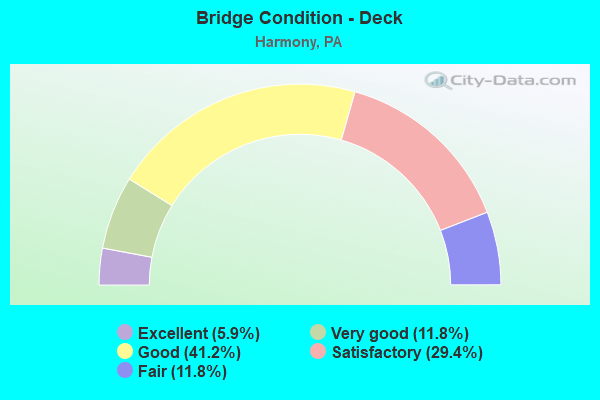
- Bridge Condition - Deck
- 5.9%Excellent
- 11.8%Very good
- 41.2%Good
- 29.4%Satisfactory
- 11.8%Fair
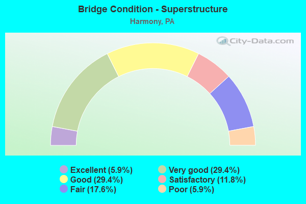
- Bridge Condition - Superstructure
- 5.9%Excellent
- 29.4%Very good
- 29.4%Good
- 11.8%Satisfactory
- 17.6%Fair
- 5.9%Poor
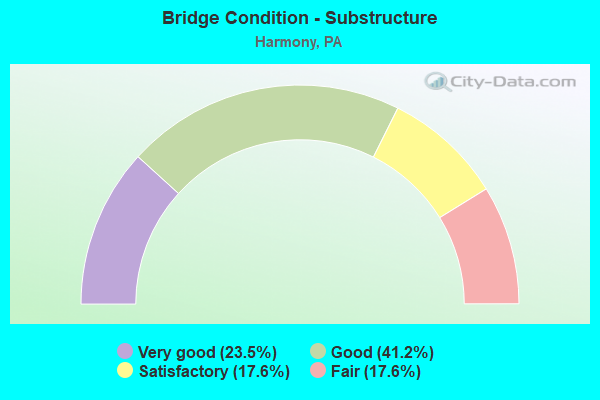
- Bridge Condition - Substructure
- 23.5%Very good
- 41.2%Good
- 17.6%Satisfactory
- 17.6%Fair
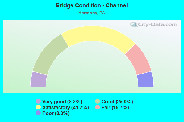
- Bridge Condition - Channel
- 8.3%Very good
- 25.0%Good
- 41.7%Satisfactory
- 16.7%Fair
- 8.3%Poor
Find on map >> Show street view
Structure Number: 7835, Location: HARMONY BORO (Lat: 40.801267, Lng: -80.125483), Route carried "on" structure: State highway 68, Year Built: 1958, Status: Open, Structure Length: 1.34m (4.40ft), Average Daily Traffic: 7,448 (year 2020), Truck Traffic: 10%, Average Future Daily Traffic: 12,770 (year 2032), Design Load: HS 20, Features Intersected: SPRING STREET
Minimum Vertical Clearance: 30+ m (98+ ft), Kilometerpoint: 3.143, Lanes on structure: 2, Lanes under structure: 2, Owner: State Highway Agency, Approaching Roadway Width: 11.6m (38.1ft), Material/Design: Concrete, Design/Construction: Tee Beam, Number Of Spans In Main Unit: 1, Length of Maximum Span: 12.2m (40.0ft), Curb or Sidewalk Widths: Left: 0.2m (0.7ft), Right: 0.2m (0.7ft), Curb-To-Curb Width: 12.2m (40.0ft), Out-to-Out Width: 13.1m (43.0ft)
Condition: Deck: Satisfactory, Superstructure: Satisfactory, Substructure: Fair, Operating Rating: 86.2 metric tons, Method Used To Determine Operating Rating: Load Factor (LF), Inventory Rating: 51.7 metric tons, Method Used To Determine Inventory Rating: Load Factor (LF), Structural Evaluation: Somewhat better than minimum adequacy, Deck Geometry: Somewhat better than minimum adequacy, Underclear: High priority of corrective action, Approach Roadway Alignment: Equal to present desirable criteria, Length Of Structure Improvement: 2.00m (6.56ft), Designated Inspection Frequency: Every 24 months, Inspection Date: October 2021, Bridge Improvement Cost: $16,000, Roadway Improvement Cost: $85,000, Total Project Cost: $216,000, Deck Structure Type: Concrete Cast-file-Place, Wearing Surface/Protective System: Wearing Surface: Bituminous, Membrane: Preformed Fabric
Find on map >> Show street view
Structure Number: 7866, Location: HARMONY NB (Lat: 40.801697, Lng: -80.117908), Route carried "on" structure: Interstate 79, Year Built: 1962, Year Reconstructed: 2005, Status: Open, Structure Length: 20.82m (68.31ft), Average Daily Traffic: 16,330 (year 2021), Truck Traffic: 12%, Average Future Daily Traffic: 21,073 (year 2032), Design Load: HS 20+Mod, Features Intersected: PA 68,T-323,B&P RR & CRK
Minimum Vertical Clearance: 30+ m (98+ ft), Kilometerpoint: 14.870, Lanes on structure: 2, Lanes under structure: 6, Base Highway Network: Yes, Owner: State Highway Agency, Approaching Roadway Width: 10.7m (35.1ft), Skew: 10 degrees, Material/Design: Steel continuous, Design/Construction: Girder and Floorbeam System, Number Of Spans In Main Unit: 3, Number Of Approach Spans: 2, Length of Maximum Span: 58.5m (191.9ft), Curb-To-Curb Width: 10.7m (35.1ft), Out-to-Out Width: 11.4m (37.4ft)
Condition: Deck: Good, Superstructure: Fair, Substructure: Satisfactory, Channel: Satisfactory, Operating Rating: 50.8 metric tons, Method Used To Determine Operating Rating: Load Factor (LF), Inventory Rating: 29.9 metric tons, Method Used To Determine Inventory Rating: Load Factor (LF), Structural Evaluation: Somewhat better than minimum adequacy, Deck Geometry: Meets minimum limits, Underclear: Meets minimum limits, Waterway Adequacy: Superior to present desirable criteria, Approach Roadway Alignment: Equal to present desirable criteria, Length Of Structure Improvement: 21.40m (70.21ft), Designated Inspection Frequency: Every 24 months, Critical Feature Inspection Frequency: Every 24 months, Inspection Date: September 2021, Critical Feature Inspection Date: September 2021, Bridge Improvement Cost: $45,000, Roadway Improvement Cost: $149,000, Total Project Cost: $612,000, Deck Structure Type: Concrete Cast-file-Place, Wearing Surface/Protective System: Wearing Surface: Epoxy Overlay, Membrane: Epoxy, Deck Protection: Epoxy Coated Reinforcing
Find on map >> Show street view
Structure Number: 7867, Location: HARMONY SB (Lat: 40.801531, Lng: -80.118231), Route carried "on" structure: Interstate 79, Year Built: 1962, Year Reconstructed: 1989, Status: Open, Structure Length: 19.14m (62.80ft), Average Daily Traffic: 17,415 (year 2021), Truck Traffic: 11%, Average Future Daily Traffic: 22,461 (year 2032), Design Load: HS 20+Mod, Features Intersected: PA 68,T-323,B&P RR & CRK
Minimum Vertical Clearance: 30+ m (98+ ft), Kilometerpoint: 14.828, Lanes on structure: 2, Lanes under structure: 6, Base Highway Network: Yes, Owner: State Highway Agency, Approaching Roadway Width: 10.7m (35.1ft), Skew: 10 degrees, Material/Design: Steel continuous, Design/Construction: Girder and Floorbeam System, Number Of Spans In Main Unit: 3, Number Of Approach Spans: 1, Length of Maximum Span: 58.5m (191.9ft), Curb-To-Curb Width: 10.7m (35.1ft), Out-to-Out Width: 11.6m (38.1ft)
Condition: Deck: Satisfactory, Superstructure: Fair, Substructure: Satisfactory, Channel: Satisfactory, Operating Rating: 50.8 metric tons, Method Used To Determine Operating Rating: Load Factor (LF), Inventory Rating: 29.9 metric tons, Method Used To Determine Inventory Rating: Load Factor (LF), Structural Evaluation: Somewhat better than minimum adequacy, Deck Geometry: Meets minimum limits, Underclear: Meets minimum limits, Waterway Adequacy: Superior to present desirable criteria, Approach Roadway Alignment: Equal to present desirable criteria, Length Of Structure Improvement: 19.80m (64.96ft), Designated Inspection Frequency: Every 24 months, Critical Feature Inspection Frequency: Every 24 months, Inspection Date: September 2021, Critical Feature Inspection Date: September 2021, Bridge Improvement Cost: $96,000, Roadway Improvement Cost: $282,000, Total Project Cost: $1,293,000, Deck Structure Type: Concrete Cast-file-Place, Wearing Surface/Protective System: Wearing Surface: Epoxy Overlay, Membrane: Epoxy, Deck Protection: Epoxy Coated Reinforcing
Find on map >> Show street view
Structure Number: 787, Location: NORTH OF HARMONY (Lat: 40.855722, Lng: -80.106333), Route carried "on" structure: Interstate 79, Year Built: 1962, Status: Open, Structure Length: 0.98m (3.22ft), Average Daily Traffic: 15,515 (year 2021), Truck Traffic: 16%, Average Future Daily Traffic: 14,990 (year 2032), Design Load: HS 20+Mod, Features Intersected: TWP RD 347
Minimum Vertical Clearance: 30+ m (98+ ft), Kilometerpoint: 21.660, Lanes on structure: 2, Lanes under structure: 2, Base Highway Network: Yes, Owner: State Highway Agency, Approaching Roadway Width: 11.6m (38.1ft), Skew: 10 degrees, Material/Design: Prestressed concrete, Design/Construction: Box Beam or Girders - Single/Spread, Number Of Spans In Main Unit: 1, Length of Maximum Span: 9.1m (29.9ft), Curb-To-Curb Width: 13.4m (44.0ft), Out-to-Out Width: 14.1m (46.3ft)
Condition: Deck: Very good, Superstructure: Good, Substructure: Good, Operating Rating: 62.6 metric tons, Method Used To Determine Operating Rating: Load Factor (LF), Inventory Rating: 37.2 metric tons, Method Used To Determine Inventory Rating: Load Factor (LF), Structural Evaluation: Better than present minimum criteria, Deck Geometry: Superior to present desirable criteria, Underclear: Somewhat better than minimum adequacy, Approach Roadway Alignment: Equal to present desirable criteria, Length Of Structure Improvement: 1.60m (5.25ft), Designated Inspection Frequency: Every 24 months, Inspection Date: July 2020, Deck Structure Type: Concrete Cast-file-Place, Wearing Surface/Protective System: Wearing Surface: Epoxy Overlay, Membrane: Epoxy, Deck Protection: Epoxy Coated Reinforcing
Find on map >> Show street view
Structure Number: 7871, Location: NORTH OF HARMONY (Lat: 40.855747, Lng: -80.106689), Route carried "on" structure: Interstate 79, Year Built: 1962, Status: Open, Structure Length: 0.98m (3.22ft), Average Daily Traffic: 16,252 (year 2021), Truck Traffic: 16%, Average Future Daily Traffic: 13,968 (year 2032), Design Load: HS 20+Mod, Features Intersected: TWP RD 347
Minimum Vertical Clearance: 30+ m (98+ ft), Kilometerpoint: 21.610, Lanes on structure: 2, Lanes under structure: 2, Base Highway Network: Yes, Owner: State Highway Agency, Approaching Roadway Width: 11.6m (38.1ft), Skew: 10 degrees, Material/Design: Prestressed concrete, Design/Construction: Box Beam or Girders - Single/Spread, Number Of Spans In Main Unit: 1, Length of Maximum Span: 9.1m (29.9ft), Curb-To-Curb Width: 13.1m (43.0ft), Out-to-Out Width: 14.2m (46.6ft)
Condition: Deck: Good, Superstructure: Good, Substructure: Good, Operating Rating: 62.6 metric tons, Method Used To Determine Operating Rating: Load Factor (LF), Inventory Rating: 37.2 metric tons, Method Used To Determine Inventory Rating: Load Factor (LF), Structural Evaluation: Better than present minimum criteria, Deck Geometry: Superior to present desirable criteria, Underclear: Meets minimum limits, Approach Roadway Alignment: Equal to present desirable criteria, Length Of Structure Improvement: 1.60m (5.25ft), Designated Inspection Frequency: Every 24 months, Inspection Date: July 2020, Deck Structure Type: Concrete Cast-file-Place, Wearing Surface/Protective System: Wearing Surface: Epoxy Overlay, Deck Protection: Epoxy Coated Reinforcing
Find on map >> Show street view
Structure Number: 8251, Location: 0.3 MI N of T-399 (Lat: 40.833044, Lng: -80.074594), Route carried "on" structure: City street , Year Built: 1920, Year Reconstructed: 1990, Status: Open, Structure Length: 1.31m (4.30ft), Average Daily Traffic: 350 (year 2017), Truck Traffic: 9%, Average Future Daily Traffic: 375 (year 2037), Features Intersected: CRAB RUN, Facility Carried by Structure: T-341 CRAB RUN RD
Minimum Vertical Clearance: 30+ m (98+ ft), Kilometerpoint: 0.000, Lanes on structure: 2, Owner: County Highway Agency, Approaching Roadway Width: 4.9m (16.1ft), Skew: 2 degrees, Material/Design: Steel, Design/Construction: Stringer/Multi-beam, Number Of Spans In Main Unit: 1, Length of Maximum Span: 12.5m (41.0ft), Curb or Sidewalk Widths: Left: 0.2m (0.7ft), Right: 0.2m (0.7ft), Curb-To-Curb Width: 5.0m (16.4ft), Out-to-Out Width: 5.4m (17.7ft)
Condition: Deck: Fair, Superstructure: Fair, Substructure: Fair, Channel: Satisfactory, Operating Rating: 89.8 metric tons, Method Used To Determine Operating Rating: Load Factor (LF), Inventory Rating: 54.4 metric tons, Method Used To Determine Inventory Rating: Load Factor (LF), Structural Evaluation: Somewhat better than minimum adequacy, Deck Geometry: High priority of replacement, Waterway Adequacy: Better than present minimum criteria, Approach Roadway Alignment: Somewhat better than minimum adequacy, Length Of Structure Improvement: 2.00m (6.56ft), Designated Inspection Frequency: Every 24 months, Inspection Date: July 2021, Bridge Improvement Cost: $6,000, Roadway Improvement Cost: $16,000, Total Project Cost: $75,000, Deck Structure Type: Concrete Cast-file-Place, Wearing Surface/Protective System: Wearing Surface: Monolithic Concrete, Deck Protection: Epoxy Coated Reinforcing
Find on map >> Show street view
Structure Number: 8321, Location: HARMONY MAIN STREET (Lat: 40.802100, Lng: -80.127600), Route carried "on" structure: City street 7409, Year Built: 1916, Year Reconstructed: 1978, Status: Open, Structure Length: 1.01m (3.31ft), Average Daily Traffic: 50 (year 2005), Average Future Daily Traffic: 70 (year 2022), Features Intersected: B&P RAILROAD, Facility Carried by Structure: MAIN STREET
Minimum Vertical Clearance: 30+ m (98+ ft), Kilometerpoint: 0.000, Lanes on structure: 2, Owner: Railroad, Approaching Roadway Width: 8.2m (26.9ft), Material/Design: Prestressed concrete, Design/Construction: Box Beam or Girders - Multiple, Number Of Spans In Main Unit: 1, Length of Maximum Span: 8.8m (28.9ft), Curb or Sidewalk Widths: Left: 1.5m (4.9ft), Right: 1.5m (4.9ft), Curb-To-Curb Width: 8.2m (26.9ft), Out-to-Out Width: 12.0m (39.4ft)
Condition: Deck: Fair, Superstructure: Poor, Substructure: Fair, Operating Rating: 49.0 metric tons, Method Used To Determine Operating Rating: Field evaluation and documented engineering judgment, Inventory Rating: 32.7 metric tons, Method Used To Determine Inventory Rating: Field evaluation and documented engineering judgment, Structural Evaluation: Meets minimum limits, Deck Geometry: Equal to present minimum criteria, Underclear: High priority of corrective action, Approach Roadway Alignment: Equal to present desirable criteria, Length Of Structure Improvement: 1.60m (5.25ft), Designated Inspection Frequency: Every 24 months, Inspection Date: May 2020, Deck Structure Type: Other, Wearing Surface/Protective System: Wearing Surface: Bituminous
Find on map >> Show street view
Structure Number: 33136, Location: 0.75 MI SE OF WESTFIELD (Lat: 41.917825, Lng: -77.522203), Route carried "on" structure: State highway , Year Built: 1952, Year Reconstructed: 2007, Status: Open, Structure Length: 0.91m (2.99ft), Average Daily Traffic: 94 (year 2020), Truck Traffic: 7%, Average Future Daily Traffic: 222 (year 2032), Features Intersected: BROUGHTON BROOK, Facility Carried by Structure: SR 4003
Minimum Vertical Clearance: 30+ m (98+ ft), Kilometerpoint: 0.000, Lanes on structure: 2, Owner: State Highway Agency, Approaching Roadway Width: 5.5m (18.0ft), Skew: 4 degrees, Material/Design: Concrete, Design/Construction: Channel Beam, Number Of Spans In Main Unit: 1, Length of Maximum Span: 8.8m (28.9ft), Curb-To-Curb Width: 6.5m (21.3ft), Out-to-Out Width: 7.4m (24.3ft)
Condition: Deck: Good, Superstructure: Satisfactory, Substructure: Satisfactory, Channel: Poor, Inventory Rating: 99.8 metric tons, Method Used To Determine Inventory Rating: Load Factor (LF), Structural Evaluation: Equal to present minimum criteria, Deck Geometry: Somewhat better than minimum adequacy, Waterway Adequacy: Better than present minimum criteria, Approach Roadway Alignment: Equal to present desirable criteria, Length Of Structure Improvement: 0.90m (2.95ft), Designated Inspection Frequency: Every 48 months, Inspection Date: August 2018, Bridge Improvement Cost: $12,000, Roadway Improvement Cost: $50,000, Total Project Cost: $156,000, Wearing Surface/Protective System: Wearing Surface: Bituminous, Membrane: Preformed Fabric
Find on map >> Show street view
Structure Number: 40965, Location: 100 FT S EVERGREEN MILL (Lat: 40.804353, Lng: -80.123889), Route carried "on" structure: City street , Year Built: 2000, Status: Open, Structure Length: 3.78m (12.40ft), Average Daily Traffic: 1,200 (year 2015), Truck Traffic: 9%, Average Future Daily Traffic: 920 (year 2035), Features Intersected: CONNOQUENESSING CR, Facility Carried by Structure: MERCER STREET
Minimum Vertical Clearance: 30+ m (98+ ft), Kilometerpoint: 0.000, Lanes on structure: 2, Owner: County Highway Agency, Approaching Roadway Width: 9.1m (29.9ft), Material/Design: Steel, Design/Construction: Stringer/Multi-beam, Number Of Spans In Main Unit: 1, Length of Maximum Span: 36.0m (118.1ft), Curb or Sidewalk Widths: Left: 2.3m (7.5ft), Right: 0.6m (2.0ft), Curb-To-Curb Width: 9.1m (29.9ft), Out-to-Out Width: 12.1m (39.7ft)
Condition: Deck: Satisfactory, Superstructure: Good, Substructure: Good, Channel: Good, Operating Rating: 79.8 metric tons, Method Used To Determine Operating Rating: Load Factor (LF), Inventory Rating: 47.2 metric tons, Method Used To Determine Inventory Rating: Load Factor (LF), Structural Evaluation: Better than present minimum criteria, Deck Geometry: Somewhat better than minimum adequacy, Waterway Adequacy: Superior to present desirable criteria, Approach Roadway Alignment: Meets minimum limits, Length Of Structure Improvement: 3.70m (12.14ft), Designated Inspection Frequency: Every 24 months, Inspection Date: July 2021, Deck Structure Type: Concrete Cast-file-Place, Wearing Surface/Protective System: Wearing Surface: Monolithic Concrete, Deck Protection: Epoxy Coated Reinforcing
Find on map >> Show street view
Structure Number: 42618, Location: AT INTERSECTION W/SR 3027 (Lat: 40.803069, Lng: -80.094644), Route carried "on" structure: City street , Year Built: 2004, Status: Open, Structure Length: 4.36m (14.30ft), Average Daily Traffic: 150 (year 2015), Truck Traffic: 9%, Average Future Daily Traffic: 175 (year 2035), Features Intersected: CONNOQUENESSING CR, Facility Carried by Structure: T-332 TEXTOR HILL
Minimum Vertical Clearance: 30+ m (98+ ft), Kilometerpoint: 0.000, Lanes on structure: 2, Owner: County Highway Agency, Approaching Roadway Width: 7.3m (24.0ft), Skew: 1 degrees, Material/Design: Prestressed concrete, Design/Construction: Box Beam or Girders - Single/Spread, Number Of Spans In Main Unit: 2, Length of Maximum Span: 21.3m (69.9ft), Curb or Sidewalk Widths: Left: 0.2m (0.7ft), Right: 0.2m (0.7ft), Curb-To-Curb Width: 8.4m (27.6ft), Out-to-Out Width: 9.3m (30.5ft)
Condition: Deck: Satisfactory, Superstructure: Good, Substructure: Good, Channel: Fair, Operating Rating: 49.0 metric tons, Method Used To Determine Operating Rating: Load and Resistance Factor (LRFR), Inventory Rating: 38.1 metric tons, Method Used To Determine Inventory Rating: Load and Resistance Factor (LRFR), Structural Evaluation: Better than present minimum criteria, Deck Geometry: Somewhat better than minimum adequacy, Waterway Adequacy: Superior to present desirable criteria, Approach Roadway Alignment: Equal to present minimum criteria, Length Of Structure Improvement: 5.90m (19.36ft), Designated Inspection Frequency: Every 24 months, Inspection Date: December 2019, Deck Structure Type: Concrete Cast-file-Place, Wearing Surface/Protective System: Wearing Surface: Monolithic Concrete, Deck Protection: Epoxy Coated Reinforcing
Find on map >> Show street view
Structure Number: 45969, Location: 0.1 MI. N. SR 68 INTER. (Lat: 40.796767, Lng: -80.102803), Route carried "on" structure: State highway , Year Built: 2010, Status: Open, Structure Length: 20.94m (68.70ft), Average Daily Traffic: 1,553 (year 2022), Truck Traffic: 1%, Average Future Daily Traffic: 2,394 (year 2032), Design Load: HL 93, Features Intersected: CONNOQUEN. CR & B&P RR, Facility Carried by Structure: SR3027
Minimum Vertical Clearance: 30+ m (98+ ft), Kilometerpoint: 0.000, Lanes on structure: 2, Owner: State Highway Agency, Approaching Roadway Width: 6.7m (22.0ft), Material/Design: Steel continuous, Design/Construction: Stringer/Multi-beam, Number Of Spans In Main Unit: 6, Length of Maximum Span: 47.2m (154.9ft), Curb or Sidewalk Widths: Left: 0.2m (0.7ft), Right: 0.2m (0.7ft), Curb-To-Curb Width: 9.1m (29.9ft), Out-to-Out Width: 10.2m (33.5ft)
Condition: Deck: Good, Superstructure: Very good, Substructure: Very good, Channel: Satisfactory, Operating Rating: 72.6 metric tons, Method Used To Determine Operating Rating: Load and Resistance Factor (LRFR), Inventory Rating: 55.3 metric tons, Method Used To Determine Inventory Rating: Load and Resistance Factor (LRFR), Structural Evaluation: Equal to present desirable criteria, Deck Geometry: Somewhat better than minimum adequacy, Underclear: High priority of corrective action, Waterway Adequacy: Equal to present desirable criteria, Approach Roadway Alignment: Better than present minimum criteria, Designated Inspection Frequency: Every 48 months, Inspection Date: December 2019, Deck Structure Type: Concrete Cast-file-Place, Wearing Surface/Protective System: Wearing Surface: Monolithic Concrete, Deck Protection: Epoxy Coated Reinforcing
Find on map >> Show street view
Structure Number: 46853, Location: 0.25 MI NW SR 3027 (Lat: 40.801500, Lng: -80.104697), Route carried "on" structure: City street , Year Built: 2011, Status: Open, Structure Length: 2.83m (9.28ft), Average Daily Traffic: 750 (year 2015), Average Future Daily Traffic: 775 (year 2035), Design Load: HL 93, Features Intersected: LITTL CONNOQUENESSING CR, Facility Carried by Structure: T-323 EVERGRN MILL
Minimum Vertical Clearance: 30+ m (98+ ft), Kilometerpoint: 0.000, Lanes on structure: 2, Owner: County Highway Agency, Approaching Roadway Width: 9.1m (29.9ft), Material/Design: Prestressed concrete, Design/Construction: Box Beam or Girders - Single/Spread, Number Of Spans In Main Unit: 1, Length of Maximum Span: 28.0m (91.9ft), Curb or Sidewalk Widths: Left: 0.2m (0.7ft), Right: 0.2m (0.7ft), Curb-To-Curb Width: 9.1m (29.9ft), Out-to-Out Width: 10.2m (33.5ft)
Condition: Deck: Good, Superstructure: Good, Substructure: Good, Channel: Satisfactory, Operating Rating: 72.6 metric tons, Method Used To Determine Operating Rating: Assigned ratings based on Load and Resistance Factor Design (LRFD) reported by rating factor (RF) using HL93 loadings, Inventory Rating: 38.6 metric tons, Method Used To Determine Inventory Rating: Assigned ratings based on Load and Resistance Factor Design (LRFD) reported by rating factor (RF) using HL93 loadings, Structural Evaluation: Better than present minimum criteria, Deck Geometry: Equal to present minimum criteria, Waterway Adequacy: Better than present minimum criteria, Approach Roadway Alignment: Better than present minimum criteria, Designated Inspection Frequency: Every 24 months, Inspection Date: November 2019, Deck Structure Type: Concrete Cast-file-Place, Wearing Surface/Protective System: Wearing Surface: Monolithic Concrete, Deck Protection: Epoxy Coated Reinforcing
Find on map >> Show street view
Structure Number: 46947, Location: 0.5 Mi W SR 19 Intersect. (Lat: 40.810972, Lng: -80.116917), Route carried "on" structure: State highway , Year Built: 2011, Status: Open, Structure Length: 6.92m (22.70ft), Average Daily Traffic: 4,986 (year 2022), Truck Traffic: 7%, Average Future Daily Traffic: 9,178 (year 2032), Design Load: HL 93, Features Intersected: SR 0079 NB & SB, Facility Carried by Structure: SR 3025
Minimum Vertical Clearance: 30+ m (98+ ft), Kilometerpoint: 0.855, Lanes on structure: 2, Lanes under structure: 4, Owner: State Highway Agency, Approaching Roadway Width: 7.6m (24.9ft), Skew: 22 degrees, Material/Design: Prestressed concrete, Design/Construction: Stringer/Multi-beam, Number Of Spans In Main Unit: 2, Length of Maximum Span: 36.6m (120.1ft), Curb or Sidewalk Widths: Left: 0.2m (0.7ft), Right: 0.2m (0.7ft), Curb-To-Curb Width: 17.1m (56.1ft), Out-to-Out Width: 18.1m (59.4ft)
Condition: Deck: Good, Superstructure: Very good, Substructure: Good, Operating Rating: 66.4 metric tons, Method Used To Determine Operating Rating: Assigned ratings based on Load and Resistance Factor Design (LRFD) reported by rating factor (RF) using HL93 loadings, Inventory Rating: 38.6 metric tons, Method Used To Determine Inventory Rating: Assigned ratings based on Load and Resistance Factor Design (LRFD) reported by rating factor (RF) using HL93 loadings, Structural Evaluation: Better than present minimum criteria, Deck Geometry: Superior to present desirable criteria, Underclear: Equal to present minimum criteria, Approach Roadway Alignment: Equal to present desirable criteria, Designated Inspection Frequency: Every 48 months, Inspection Date: Febuary 2021, Deck Structure Type: Concrete Cast-file-Place, Wearing Surface/Protective System: Wearing Surface: Monolithic Concrete, Deck Protection: Epoxy Coated Reinforcing
Find on map >> Show street view
Structure Number: 47899, Location: 0.1 mile NE of SR 68 In (Lat: 40.792814, Lng: -80.093578), Route carried "on" structure: City street , Year Built: 2013, Status: Open, Structure Length: 2.23m (7.32ft), Average Daily Traffic: 200 (year 2017), Truck Traffic: 9%, Average Future Daily Traffic: 225 (year 2037), Design Load: HL 93, Features Intersected: BREAKNECK CREEK, Facility Carried by Structure: T-325 TEXTOR SCH'L
Minimum Vertical Clearance: 30+ m (98+ ft), Kilometerpoint: 0.000, Lanes on structure: 2, Owner: County Highway Agency, Approaching Roadway Width: 8.8m (28.9ft), Skew: 1 degrees, Material/Design: Prestressed concrete, Design/Construction: Stringer/Multi-beam, Number Of Spans In Main Unit: 1, Length of Maximum Span: 21.3m (69.9ft), Curb or Sidewalk Widths: Left: 0.2m (0.7ft), Right: 0.2m (0.7ft), Curb-To-Curb Width: 8.7m (28.5ft), Out-to-Out Width: 9.8m (32.2ft)
Condition: Deck: Satisfactory, Superstructure: Very good, Substructure: Good, Channel: Fair, Operating Rating: 68.7 metric tons, Method Used To Determine Operating Rating: Assigned ratings based on Load and Resistance Factor Design (LRFD) reported by rating factor (RF) using HL93 loadings, Inventory Rating: 43.1 metric tons, Method Used To Determine Inventory Rating: Assigned ratings based on Load and Resistance Factor Design (LRFD) reported by rating factor (RF) using HL93 loadings, Structural Evaluation: Better than present minimum criteria, Deck Geometry: Equal to present minimum criteria, Waterway Adequacy: Superior to present desirable criteria, Approach Roadway Alignment: Somewhat better than minimum adequacy, Designated Inspection Frequency: Every 24 months, Inspection Date: June 2021, Deck Structure Type: Concrete Cast-file-Place, Wearing Surface/Protective System: Wearing Surface: Monolithic Concrete, Deck Protection: Epoxy Coated Reinforcing
Find on map >> Show street view
Structure Number: 47939, Location: 1 Mi N SR 3027 Inter. (Lat: 40.824053, Lng: -80.097575), Route carried "on" structure: State highway , Year Built: 2013, Status: Open, Structure Length: 4.36m (14.30ft), Average Daily Traffic: 288 (year 2022), Truck Traffic: 3%, Average Future Daily Traffic: 300 (year 2032), Design Load: HL 93, Features Intersected: LT CONNOQUEN CR, Facility Carried by Structure: SR 3025
Minimum Vertical Clearance: 30+ m (98+ ft), Kilometerpoint: 3.317, Lanes on structure: 2, Owner: State Highway Agency, Approaching Roadway Width: 6.7m (22.0ft), Skew: 1 degrees, Material/Design: Steel continuous, Design/Construction: Stringer/Multi-beam, Number Of Spans In Main Unit: 2, Length of Maximum Span: 21.3m (69.9ft), Curb or Sidewalk Widths: Left: 0.2m (0.7ft), Right: 0.2m (0.7ft), Curb-To-Curb Width: 9.1m (29.9ft), Out-to-Out Width: 10.2m (33.5ft)
Condition: Deck: Very good, Superstructure: Very good, Substructure: Very good, Channel: Good, Operating Rating: 52.8 metric tons, Method Used To Determine Operating Rating: Assigned ratings based on Load and Resistance Factor Design (LRFD) reported by rating factor (RF) using HL93 loadings, Inventory Rating: 37.9 metric tons, Method Used To Determine Inventory Rating: Assigned ratings based on Load and Resistance Factor Design (LRFD) reported by rating factor (RF) using HL93 loadings, Structural Evaluation: Equal to present desirable criteria, Deck Geometry: Equal to present minimum criteria, Waterway Adequacy: Equal to present minimum criteria, Approach Roadway Alignment: Better than present minimum criteria, Designated Inspection Frequency: Every 48 months, Inspection Date: August 2020, Deck Structure Type: Concrete Cast-file-Place, Wearing Surface/Protective System: Wearing Surface: Monolithic Concrete, Deck Protection: Epoxy Coated Reinforcing
Find on map >> Show street view
Structure Number: 52691, Location: 0.5 Mi. S SR 3025 Inter. (Lat: 40.806808, Lng: -80.133028), Route carried "on" structure: US 19, Year Built: 2015, Status: Open, Structure Length: 2.29m (7.51ft), Average Daily Traffic: 8,824 (year 2022), Truck Traffic: 13%, Average Future Daily Traffic: 13,795 (year 2032), Design Load: HL 93, Features Intersected: SCHOLARS RUN
Minimum Vertical Clearance: 30+ m (98+ ft), Kilometerpoint: 15.603, Lanes on structure: 2, Owner: State Highway Agency, Approaching Roadway Width: 7.9m (25.9ft), Skew: 4 degrees, Material/Design: Prestressed concrete, Design/Construction: Stringer/Multi-beam, Number Of Spans In Main Unit: 1, Length of Maximum Span: 21.6m (70.9ft), Curb or Sidewalk Widths: Left: 0.2m (0.7ft), Right: 0.2m (0.7ft), Curb-To-Curb Width: 13.1m (43.0ft), Out-to-Out Width: 14.1m (46.3ft)
Condition: Deck: Good, Superstructure: Very good, Substructure: Very good, Channel: Good, Operating Rating: 51.8 metric tons, Method Used To Determine Operating Rating: Assigned ratings based on Load and Resistance Factor Design (LRFD) reported by rating factor (RF) using HL93 loadings, Inventory Rating: 39.9 metric tons, Method Used To Determine Inventory Rating: Assigned ratings based on Load and Resistance Factor Design (LRFD) reported by rating factor (RF) using HL93 loadings, Structural Evaluation: Equal to present desirable criteria, Deck Geometry: Somewhat better than minimum adequacy, Waterway Adequacy: Equal to present minimum criteria, Approach Roadway Alignment: Equal to present desirable criteria, Designated Inspection Frequency: Every 48 months, Inspection Date: May 2021, Deck Structure Type: Concrete Cast-file-Place, Wearing Surface/Protective System: Wearing Surface: Monolithic Concrete, Deck Protection: Epoxy Coated Reinforcing
Find on map >> Show street view
Structure Number: 54113, Location: SENECA SCHOOL (Lat: 40.810950, Lng: -80.108456), Route carried "on" structure: State highway , Year Built: 2017, Status: Open, Structure Length: 3.90m (12.80ft), Average Daily Traffic: 2,657 (year 2020), Truck Traffic: 31%, Average Future Daily Traffic: 3,446 (year 2037), Design Load: HL 93, Features Intersected: LIT CONNOQUENESSING CR, Facility Carried by Structure: SENECA SCHOOL RD
Minimum Vertical Clearance: 30+ m (98+ ft), Kilometerpoint: 2.795, Lanes on structure: 2, Owner: State Highway Agency, Maintenance Responsibility: Private, Approaching Roadway Width: 9.8m (32.2ft), Skew: 2 degrees, Material/Design: Prestressed concrete, Design/Construction: Stringer/Multi-beam, Number Of Spans In Main Unit: 1, Length of Maximum Span: 38.1m (125.0ft), Curb-To-Curb Width: 14.5m (47.6ft), Out-to-Out Width: 15.1m (49.5ft)
Condition: Deck: Excellent, Superstructure: Excellent, Substructure: Very good, Channel: Very good, Operating Rating: 57.7 metric tons, Method Used To Determine Operating Rating: Assigned ratings based on Load and Resistance Factor Design (LRFD) reported by rating factor (RF) using HL93 loadings, Inventory Rating: 38.9 metric tons, Method Used To Determine Inventory Rating: Assigned ratings based on Load and Resistance Factor Design (LRFD) reported by rating factor (RF) using HL93 loadings, Structural Evaluation: Equal to present desirable criteria, Deck Geometry: Superior to present desirable criteria, Waterway Adequacy: Superior to present desirable criteria, Approach Roadway Alignment: Equal to present desirable criteria, Designated Inspection Frequency: Every 24 months, Inspection Date: May 2021, Deck Structure Type: Concrete Cast-file-Place, Wearing Surface/Protective System: Wearing Surface: Integral Concrete, Deck Protection: Epoxy Coated Reinforcing
Find on map >> Show street view
Structure Number: 7835, Location: HARMONY BORO (Lat: 40.801267, Lng: -80.125483), Route carried "under" structure: City street , Year Built: 1958, Structure Length: 0. m, Average Daily Traffic: 300 (year 2018), Truck Traffic: 5%, Features Intersected: SPRING STREET, Facility Carried by Structure: SR0068
Minimum Vertical Clearance: 5.10m (16.73ft), Kilometerpoint: 0.000, Lanes on structure: 2, Lanes under structure: 2, Material/Design: Concrete, Design/Construction: Tee Beam, Length of Maximum Span: 12.2m (40.0ft)
Find on map >> Show street view
Structure Number: 7866, Location: HARMONY NB (Lat: 40.801697, Lng: -80.117908), Route carried "under" structure: State highway 68, Year Built: 1962, Structure Length: 0. m, Average Daily Traffic: 3,645 (year 2022), Truck Traffic: 13%, Features Intersected: PA 68,T-323,B&P RR & CRK, Facility Carried by Structure: SR0079 NB
Minimum Vertical Clearance: 4.66m (15.29ft), Kilometerpoint: 3.677, Lanes on structure: 2, Lanes under structure: 2, Material/Design: Steel continuous, Design/Construction: Girder and Floorbeam System, Length of Maximum Span: 58.5m (191.9ft)
Find on map >> Show street view
Structure Number: 7866, Location: HARMONY NB (Lat: 40.801697, Lng: -80.117908), Route carried "under" structure: City street , Year Built: 1962, Structure Length: 0. m, Average Daily Traffic: 100 (year 2006), Truck Traffic: 10%, Features Intersected: PA 68,T-323,B&P RR & CRK, Facility Carried by Structure: SR0079 NB
Minimum Vertical Clearance: 9.96m (32.68ft), Kilometerpoint: 0.000, Lanes on structure: 2, Lanes under structure: 2, Material/Design: Steel continuous, Design/Construction: Girder and Floorbeam System, Length of Maximum Span: 58.5m (191.9ft)
Find on map >> Show street view
Structure Number: 7866, Location: HARMONY NB (Lat: 40.801697, Lng: -80.117908), Route carried "under" structure: State highway 68, Year Built: 1962, Structure Length: 0. m, Average Daily Traffic: 3,660 (year 2022), Truck Traffic: 13%, Features Intersected: PA 68,T-323,B&P RR & CRK, Facility Carried by Structure: SR0079 NB
Minimum Vertical Clearance: 4.55m (14.93ft), Kilometerpoint: 3.677, Lanes on structure: 2, Lanes under structure: 2, Material/Design: Steel continuous, Design/Construction: Girder and Floorbeam System, Length of Maximum Span: 58.5m (191.9ft)
Find on map >> Show street view
Structure Number: 7867, Location: HARMONY SB (Lat: 40.801531, Lng: -80.118231), Route carried "under" structure: City street , Year Built: 1962, Structure Length: 0. m, Average Daily Traffic: 100 (year 2006), Truck Traffic: 10%, Features Intersected: PA 68,T-323,B&P RR & CRK, Facility Carried by Structure: SR0079 SB
Minimum Vertical Clearance: 9.34m (30.64ft), Kilometerpoint: 0.000, Lanes on structure: 2, Lanes under structure: 2, Material/Design: Steel continuous, Design/Construction: Girder and Floorbeam System, Length of Maximum Span: 58.5m (191.9ft)
Find on map >> Show street view
Structure Number: 7867, Location: HARMONY SB (Lat: 40.801531, Lng: -80.118231), Route carried "under" structure: State highway 68, Year Built: 1962, Structure Length: 0. m, Average Daily Traffic: 3,660 (year 2022), Truck Traffic: 13%, Features Intersected: PA 68,T-323,B&P RR & CRK, Facility Carried by Structure: SR0079 SB
Minimum Vertical Clearance: 4.67m (15.32ft), Kilometerpoint: 3.677, Lanes on structure: 2, Lanes under structure: 2, Material/Design: Steel continuous, Design/Construction: Girder and Floorbeam System, Length of Maximum Span: 58.5m (191.9ft)
Find on map >> Show street view
Structure Number: 7867, Location: HARMONY SB (Lat: 40.801531, Lng: -80.118231), Route carried "under" structure: State highway 68, Year Built: 1962, Structure Length: 0. m, Average Daily Traffic: 3,645 (year 2022), Truck Traffic: 13%, Features Intersected: PA 68,T-323,B&P RR & CRK, Facility Carried by Structure: SR0079 SB
Minimum Vertical Clearance: 4.90m (16.08ft), Kilometerpoint: 3.677, Lanes on structure: 2, Lanes under structure: 2, Material/Design: Steel continuous, Design/Construction: Girder and Floorbeam System, Length of Maximum Span: 58.5m (191.9ft)
Find on map >> Show street view
Structure Number: 787, Location: NORTH OF HARMONY (Lat: 40.855722, Lng: -80.106333), Route carried "under" structure: City street 347, Year Built: 1962, Structure Length: 0. m, Average Daily Traffic: 100 (year 2002), Features Intersected: TWP RD 347, Facility Carried by Structure: SR0079 NB
Minimum Vertical Clearance: 4.35m (14.27ft), Kilometerpoint: 0.000, Lanes on structure: 2, Lanes under structure: 2, Material/Design: Prestressed concrete, Design/Construction: Box Beam or Girders - Single/Spread, Length of Maximum Span: 9.1m (29.9ft)
Find on map >> Show street view
Structure Number: 7871, Location: NORTH OF HARMONY (Lat: 40.855747, Lng: -80.106689), Route carried "under" structure: City street 347, Year Built: 1962, Structure Length: 0. m, Average Daily Traffic: 100 (year 2002), Features Intersected: TWP RD 347, Facility Carried by Structure: SR 0079 SB
Minimum Vertical Clearance: 4.41m (14.47ft), Kilometerpoint: 0.000, Lanes on structure: 2, Lanes under structure: 2, Material/Design: Prestressed concrete, Design/Construction: Box Beam or Girders - Single/Spread, Length of Maximum Span: 9.1m (29.9ft)
Find on map >> Show street view
Structure Number: 46947, Location: 0.5 Mi W SR 19 Intersect. (Lat: 40.810972, Lng: -80.116917), Route carried "under" structure: Interstate 79, Year Built: 2011, Structure Length: 0. m, Average Daily Traffic: 16,330 (year 2021), Truck Traffic: 12%, Features Intersected: SR 0079 NB & SB, Facility Carried by Structure: SR 3025
Minimum Vertical Clearance: 5.18m (16.99ft), Kilometerpoint: 16.270, Lanes on structure: 2, Lanes under structure: 2, Material/Design: Prestressed concrete, Design/Construction: Stringer/Multi-beam, Length of Maximum Span: 36.6m (120.1ft)
Find on map >> Show street view
Structure Number: 46947, Location: 0.5 Mi W SR 19 Intersect. (Lat: 40.810972, Lng: -80.116917), Route carried "under" structure: Interstate 79, Year Built: 2011, Structure Length: 0. m, Average Daily Traffic: 17,415 (year 2021), Truck Traffic: 11%, Features Intersected: SR 0079 NB & SB, Facility Carried by Structure: SR 3025
Minimum Vertical Clearance: 5.28m (17.32ft), Kilometerpoint: 16.238, Lanes on structure: 2, Lanes under structure: 2, Material/Design: Prestressed concrete, Design/Construction: Stringer/Multi-beam, Length of Maximum Span: 36.6m (120.1ft)