Bridge Statistics for Harper Woods, Michigan (MI)
Condition, Traffic, Stress, Structural Evaluation, Project Costs
- National Bridge Inventory (NBI) Statistics
- 20Number of bridges
- 121ft / 37.2mTotal length
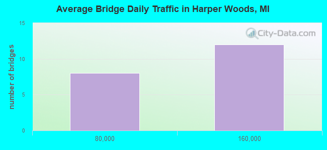
- 1,623,716Total average daily traffic
- 96,744Total average daily truck traffic
- National Bridge Inventory (NBI) Registered Bridges for Harper Woods
- No street view available for this location

- New bridges - historical statistics
- 161950-1959
- 41960-1969
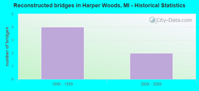
- Reconstructed bridges - Historical Statistics
- 41990-1999
- 22000-2009
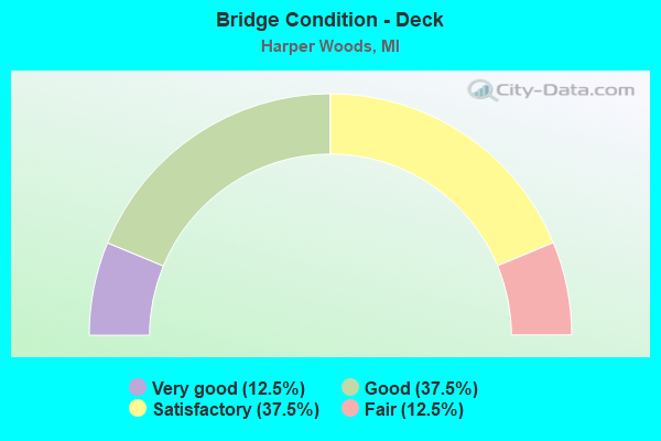
- Bridge Condition - Deck
- 12.5%Very good
- 37.5%Good
- 37.5%Satisfactory
- 12.5%Fair
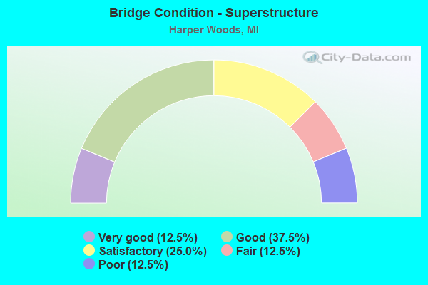
- Bridge Condition - Superstructure
- 12.5%Very good
- 37.5%Good
- 25.0%Satisfactory
- 12.5%Fair
- 12.5%Poor
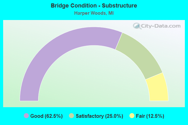
- Bridge Condition - Substructure
- 62.5%Good
- 25.0%Satisfactory
- 12.5%Fair
Find on map >> Show street view
Structure Number: 1124, Location: SHERWOOD TWP SEC 15-16 (Lat: 42.033800, Lng: -85.234800), Route carried "on" structure: County highway 1209, Year Built: 1953, Status: Open, Structure Length: 1.22m (4.00ft), Average Daily Traffic: 700 (year 2004), Truck Traffic: 4%, Average Future Daily Traffic: 1,000 (year 2024), Features Intersected: UNNAMED CREEK, Facility Carried by Structure: OLD M-78 HWY
Minimum Vertical Clearance: 30.48m (100.00ft), Kilometerpoint: 1.363, Lanes on structure: 2, Owner: County Highway Agency, Approaching Roadway Width: 10.4m (34.1ft), Material/Design: Concrete, Design/Construction: Tee Beam, Number Of Spans In Main Unit: 1, Length of Maximum Span: 11.8m (38.7ft), Curb-To-Curb Width: 8.5m (27.9ft), Out-to-Out Width: 10.2m (33.5ft)
Condition: Deck: Fair, Superstructure: Fair, Substructure: Satisfactory, Channel: Poor, Operating Rating: 61.3 metric tons, Method Used To Determine Operating Rating: Load Factor (LF), Inventory Rating: 23.4 metric tons, Method Used To Determine Inventory Rating: Load Factor (LF), Structural Evaluation: Somewhat better than minimum adequacy, Deck Geometry: Somewhat better than minimum adequacy, Waterway Adequacy: Equal to present desirable criteria, Approach Roadway Alignment: Equal to present desirable criteria, Designated Inspection Frequency: Every 24 months, Inspection Date: October 2020, Deck Structure Type: Concrete Cast-file-Place, Wearing Surface/Protective System: Wearing Surface: Bituminous
Find on map >> Show street view
Structure Number: 11263, Location: IN HARPER WOODS (Lat: 42.429267, Lng: -82.925092), Route carried "on" structure: City street , Year Built: 1959, Year Reconstructed: 2000, Status: Open, Structure Length: 4.78m (15.68ft), Average Daily Traffic: 990 (year 2007), Average Future Daily Traffic: 1,089 (year 2022), Design Load: HS 20+Mod, Features Intersected: I-94, Facility Carried by Structure: WOODSIDE AVE
Minimum Vertical Clearance: 30.48m (100.00ft), Kilometerpoint: 0.050, Lanes on structure: 2, Lanes under structure: 6, Owner: State Highway Agency, Approaching Roadway Width: 12.2m (40.0ft), Skew: 20 degrees, Material/Design: Steel continuous, Design/Construction: Stringer/Multi-beam, Number Of Spans In Main Unit: 4, Length of Maximum Span: 16.7m (54.8ft), Curb or Sidewalk Widths: Left: 1.0m (3.3ft), Right: 1.0m (3.3ft), Curb-To-Curb Width: 14.6m (47.9ft), Out-to-Out Width: 17.4m (57.1ft)
Condition: Deck: Satisfactory, Superstructure: Poor, Substructure: Satisfactory, Operating Rating: 58.6 metric tons, Method Used To Determine Operating Rating: Load Factor (LF) rating reported by rating factor (RF) method using MS18 loading, Inventory Rating: 35.0 metric tons, Method Used To Determine Inventory Rating: Load Factor (LF) rating reported by rating factor (RF) method using MS18 loading, Structural Evaluation: Meets minimum limits, Deck Geometry: Superior to present desirable criteria, Underclear: High priority of corrective action, Approach Roadway Alignment: Equal to present desirable criteria, Designated Inspection Frequency: Every 24 months, Inspection Date: June 2020, Deck Structure Type: Concrete Cast-file-Place, Wearing Surface/Protective System: Wearing Surface: Epoxy Overlay
Find on map >> Show street view
Structure Number: 11264, Location: IN HARPER WOODS (Lat: 42.433094, Lng: -82.922733), Route carried "on" structure: City street , Year Built: 1959, Year Reconstructed: 2001, Status: Open, Structure Length: 4.90m (16.08ft), Average Daily Traffic: 1,320 (year 1988), Average Future Daily Traffic: 1,518 (year 2008), Design Load: HS 20+Mod, Features Intersected: I-94, Facility Carried by Structure: ALLARD AVE
Minimum Vertical Clearance: 30.48m (100.00ft), Kilometerpoint: 1.234, Lanes on structure: 2, Lanes under structure: 6, Owner: State Highway Agency, Approaching Roadway Width: 9.1m (29.9ft), Material/Design: Prestressed concrete, Design/Construction: Box Beam or Girders - Multiple, Number Of Spans In Main Unit: 4, Length of Maximum Span: 16.7m (54.8ft), Curb or Sidewalk Widths: Left: 1.8m (5.9ft), Right: 1.8m (5.9ft), Curb-To-Curb Width: 13.4m (44.0ft), Out-to-Out Width: 17.7m (58.1ft)
Condition: Deck: Good, Superstructure: Very good, Substructure: Good, Operating Rating: 77.1 metric tons, Method Used To Determine Operating Rating: Load Factor (LF) rating reported by rating factor (RF) method using MS18 loading, Inventory Rating: 46.0 metric tons, Method Used To Determine Inventory Rating: Load Factor (LF) rating reported by rating factor (RF) method using MS18 loading, Structural Evaluation: Better than present minimum criteria, Deck Geometry: Equal to present desirable criteria, Underclear: High priority of corrective action, Approach Roadway Alignment: Equal to present desirable criteria, Designated Inspection Frequency: Every 24 months, Inspection Date: June 2020, Deck Structure Type: Concrete Cast-file-Place, Wearing Surface/Protective System: Wearing Surface: Epoxy Overlay
Find on map >> Show street view
Structure Number: 11265, Location: IN HARPER WOODS (Lat: 42.440433, Lng: -82.919328), Route carried "on" structure: City street , Year Built: 1959, Year Reconstructed: 2001, Status: Open, Structure Length: 3.23m (10.60ft), Average Daily Traffic: 800 (year 2007), Average Future Daily Traffic: 880 (year 2022), Design Load: HS 20+Mod, Features Intersected: I-94, Facility Carried by Structure: LOCHMORE AVE
Minimum Vertical Clearance: 30.48m (100.00ft), Kilometerpoint: 0.050, Lanes on structure: 2, Lanes under structure: 6, Owner: State Highway Agency, Approaching Roadway Width: 12.2m (40.0ft), Skew: 20 degrees, Material/Design: Steel continuous, Design/Construction: Stringer/Multi-beam, Number Of Spans In Main Unit: 2, Length of Maximum Span: 16.1m (52.8ft), Curb or Sidewalk Widths: Left: 1.0m (3.3ft), Right: 1.0m (3.3ft), Curb-To-Curb Width: 13.4m (44.0ft), Out-to-Out Width: 17.4m (57.1ft)
Condition: Deck: Very good, Superstructure: Satisfactory, Substructure: Good, Operating Rating: 59.2 metric tons, Method Used To Determine Operating Rating: Load Factor (LF), Inventory Rating: 34.0 metric tons, Method Used To Determine Inventory Rating: Load Factor (LF), Structural Evaluation: Equal to present minimum criteria, Deck Geometry: Superior to present desirable criteria, Underclear: High priority of corrective action, Approach Roadway Alignment: Equal to present desirable criteria, Designated Inspection Frequency: Every 24 months, Inspection Date: June 2020, Deck Structure Type: Concrete Cast-file-Place, Wearing Surface/Protective System: Wearing Surface: Epoxy Overlay, Deck Protection: Epoxy Coated Reinforcing
Find on map >> Show street view
Structure Number: 11266, Location: IN HARPER WOODS (Lat: 42.445803, Lng: -82.917208), Route carried "on" structure: State highway 102, Year Built: 1959, Year Reconstructed: 2000, Status: Open, Structure Length: 5.15m (16.90ft), Average Daily Traffic: 15,461 (year 2007), Truck Traffic: 5%, Average Future Daily Traffic: 16,661 (year 2018), Design Load: HS 20+Mod, Features Intersected: I-94
Minimum Vertical Clearance: 30.48m (100.00ft), Kilometerpoint: 1.572, Lanes on structure: 5, Lanes under structure: 6, Base Highway Network: Yes (Inventory Route: 470, Subroute: 2), Owner: State Highway Agency, Approaching Roadway Width: 14.6m (47.9ft), Skew: 10 degrees, Material/Design: Prestressed concrete, Design/Construction: Box Beam or Girders - Multiple, Number Of Spans In Main Unit: 4, Length of Maximum Span: 18.9m (62.0ft), Curb or Sidewalk Widths: Left: 1.1m (3.6ft), Right: 1.1m (3.6ft), Curb-To-Curb Width: 20.1m (65.9ft), Out-to-Out Width: 25.1m (82.3ft)
Condition: Deck: Satisfactory, Superstructure: Good, Substructure: Good, Operating Rating: 70.6 metric tons, Method Used To Determine Operating Rating: Load Factor (LF) rating reported by rating factor (RF) method using MS18 loading, Inventory Rating: 36.6 metric tons, Method Used To Determine Inventory Rating: Load Factor (LF) rating reported by rating factor (RF) method using MS18 loading, Structural Evaluation: Better than present minimum criteria, Deck Geometry: Somewhat better than minimum adequacy, Underclear: High priority of corrective action, Approach Roadway Alignment: Equal to present desirable criteria, Designated Inspection Frequency: Every 24 months, Inspection Date: June 2020, Deck Structure Type: Concrete Cast-file-Place, Wearing Surface/Protective System: Wearing Surface: Integral Concrete, Membrane: Other
Find on map >> Show street view
Structure Number: 11267, Location: IN HARPER WOODS (Lat: 42.446139, Lng: -82.917086), Route carried "on" structure: State highway 102, Year Built: 1959, Year Reconstructed: 2002, Status: Open, Structure Length: 5.30m (17.39ft), Average Daily Traffic: 15,461 (year 2007), Truck Traffic: 5%, Average Future Daily Traffic: 16,661 (year 2018), Design Load: HS 20+Mod, Features Intersected: I-94
Minimum Vertical Clearance: 30.48m (100.00ft), Kilometerpoint: 1.537, Lanes on structure: 4, Lanes under structure: 6, Base Highway Network: Yes (Inventory Route: 470, Subroute: 3), Owner: State Highway Agency, Approaching Roadway Width: 14.6m (47.9ft), Material/Design: Prestressed concrete, Design/Construction: Box Beam or Girders - Multiple, Number Of Spans In Main Unit: 4, Length of Maximum Span: 20.1m (65.9ft), Curb or Sidewalk Widths: Left: 2.4m (7.9ft), Right: 1.0m (3.3ft), Curb-To-Curb Width: 13.4m (44.0ft), Out-to-Out Width: 18.7m (61.4ft)
Condition: Deck: Good, Superstructure: Good, Substructure: Good, Operating Rating: 82.6 metric tons, Method Used To Determine Operating Rating: Load Factor (LF) rating reported by rating factor (RF) method using MS18 loading, Inventory Rating: 43.7 metric tons, Method Used To Determine Inventory Rating: Load Factor (LF) rating reported by rating factor (RF) method using MS18 loading, Structural Evaluation: Better than present minimum criteria, Deck Geometry: High priority of replacement, Underclear: High priority of corrective action, Approach Roadway Alignment: Equal to present desirable criteria, Designated Inspection Frequency: Every 24 months, Inspection Date: June 2020, Deck Structure Type: Concrete Cast-file-Place, Wearing Surface/Protective System: Wearing Surface: Integral Concrete
Find on map >> Show street view
Structure Number: 11268, Location: IN HARPER WOODS (Lat: 42.448369, Lng: -82.916517), Route carried "on" structure: City street , Year Built: 1960, Year Reconstructed: 1996, Status: Open, Structure Length: 6.76m (22.18ft), Average Daily Traffic: 870 (year 2007), Average Future Daily Traffic: 957 (year 2022), Design Load: HS 20, Features Intersected: I-94, Facility Carried by Structure: HARPER AVE
Minimum Vertical Clearance: 30.48m (100.00ft), Kilometerpoint: 0.140, Lanes on structure: 2, Lanes under structure: 6, Owner: State Highway Agency, Approaching Roadway Width: 9.1m (29.9ft), Skew: 3 degrees, Material/Design: Steel continuous, Design/Construction: Stringer/Multi-beam, Number Of Spans In Main Unit: 4, Length of Maximum Span: 21.9m (71.9ft), Curb or Sidewalk Widths: Left: 2.4m (7.9ft), Right: 0.0m, Curb-To-Curb Width: 10.8m (35.4ft), Out-to-Out Width: 14.0m (45.9ft)
Condition: Deck: Good, Superstructure: Good, Substructure: Good, Operating Rating: 58.6 metric tons, Method Used To Determine Operating Rating: Load Factor (LF) rating reported by rating factor (RF) method using MS18 loading, Inventory Rating: 35.3 metric tons, Method Used To Determine Inventory Rating: Load Factor (LF) rating reported by rating factor (RF) method using MS18 loading, Structural Evaluation: Better than present minimum criteria, Deck Geometry: Equal to present minimum criteria, Underclear: High priority of corrective action, Approach Roadway Alignment: Better than present minimum criteria, Designated Inspection Frequency: Every 24 months, Inspection Date: June 2020, Deck Structure Type: Concrete Cast-file-Place, Wearing Surface/Protective System: Wearing Surface: Monolithic Concrete
Find on map >> Show street view
Structure Number: 11269, Location: AT MACOMB CO LINE (Lat: 42.450719, Lng: -82.917183), Route carried "on" structure: City street , Year Built: 1963, Status: Open, Structure Length: 5.88m (19.29ft), Average Daily Traffic: 1,900 (year 2007), Average Future Daily Traffic: 2,090 (year 2022), Design Load: HS 20, Features Intersected: I-94, Facility Carried by Structure: 8 MI RD
Minimum Vertical Clearance: 30.48m (100.00ft), Kilometerpoint: 13.685, Lanes on structure: 2, Lanes under structure: 6, Owner: State Highway Agency, Approaching Roadway Width: 13.4m (44.0ft), Skew: 1 degrees, Material/Design: Steel continuous, Design/Construction: Stringer/Multi-beam, Number Of Spans In Main Unit: 4, Length of Maximum Span: 18.6m (61.0ft), Curb or Sidewalk Widths: Left: 2.3m (7.5ft), Right: 2.3m (7.5ft), Curb-To-Curb Width: 13.4m (44.0ft), Out-to-Out Width: 20.1m (65.9ft)
Condition: Deck: Satisfactory, Superstructure: Satisfactory, Substructure: Fair, Operating Rating: 72.3 metric tons, Method Used To Determine Operating Rating: Load Factor (LF) rating reported by rating factor (RF) method using MS18 loading, Inventory Rating: 36.6 metric tons, Method Used To Determine Inventory Rating: Load Factor (LF) rating reported by rating factor (RF) method using MS18 loading, Structural Evaluation: Somewhat better than minimum adequacy, Deck Geometry: Equal to present desirable criteria, Underclear: High priority of corrective action, Approach Roadway Alignment: Better than present minimum criteria, Designated Inspection Frequency: Every 24 months, Inspection Date: June 2020, Deck Structure Type: Concrete Cast-file-Place, Wearing Surface/Protective System: Wearing Surface: Latex Concrete
Find on map >> Show street view
Structure Number: 1124, Location: IN HARPER WOODS (Lat: 42.427336, Lng: -82.926433), Route carried "under" structure: Interstate 94, Year Built: 1959, Structure Length: 0. m, Average Daily Traffic: 130,650 (year 2011), Truck Traffic: 6%, Features Intersected: I-94, Facility Carried by Structure: KENOSHA AVE WALKOV
Minimum Vertical Clearance: 4.80m (15.75ft), Kilometerpoint: 59.141, Lanes under structure: 6, Material/Design: Steel, Design/Construction: Girder and Floorbeam System, Length of Maximum Span: 26.5m (86.9ft)
Find on map >> Show street view
Structure Number: 11241, Location: IN HARPER WOODS (Lat: 42.431303, Lng: -82.923661), Route carried "under" structure: Interstate 94, Year Built: 1959, Structure Length: 0. m, Average Daily Traffic: 130,650 (year 2011), Truck Traffic: 6%, Features Intersected: I-94, Facility Carried by Structure: WOODLAND AV WALKOV
Minimum Vertical Clearance: 5.56m (18.24ft), Kilometerpoint: 59.636, Lanes under structure: 7, Material/Design: Steel, Design/Construction: Girder and Floorbeam System, Length of Maximum Span: 23.1m (75.8ft)
Find on map >> Show street view
Structure Number: 11242, Location: IN HARPER WOODS (Lat: 42.436053, Lng: -82.921264), Route carried "under" structure: Interstate 94, Year Built: 1959, Structure Length: 0. m, Average Daily Traffic: 130,650 (year 2011), Truck Traffic: 6%, Features Intersected: I-94, Facility Carried by Structure: WOODMONT WALKOVER
Minimum Vertical Clearance: 4.82m (15.81ft), Kilometerpoint: 60.200, Lanes under structure: 6, Material/Design: Steel, Design/Construction: Girder and Floorbeam System, Length of Maximum Span: 23.4m (76.8ft)
Find on map >> Show street view
Structure Number: 11243, Location: IN HARPER WOODS (Lat: 42.438214, Lng: -82.920308), Route carried "under" structure: Interstate 94, Year Built: 1959, Structure Length: 0. m, Average Daily Traffic: 130,650 (year 2011), Truck Traffic: 6%, Features Intersected: I-94, Facility Carried by Structure: KENMORE AVE WALKOV
Minimum Vertical Clearance: 4.78m (15.68ft), Kilometerpoint: 60.452, Lanes under structure: 6, Material/Design: Steel, Design/Construction: Girder and Floorbeam System, Length of Maximum Span: 20.7m (67.9ft)
Find on map >> Show street view
Structure Number: 11244, Location: IN HARPER WOODS (Lat: 42.443114, Lng: -82.918158), Route carried "under" structure: Interstate 94, Year Built: 1959, Structure Length: 0. m, Average Daily Traffic: 137,828 (year 2007), Truck Traffic: 6%, Features Intersected: I-94, Facility Carried by Structure: BEAUFAIT AV WALKOV
Minimum Vertical Clearance: 5.00m (16.40ft), Kilometerpoint: 61.024, Lanes under structure: 8, Material/Design: Steel, Design/Construction: Girder and Floorbeam System, Length of Maximum Span: 24.7m (81.0ft)
Find on map >> Show street view
Structure Number: 11263, Location: IN HARPER WOODS (Lat: 42.429267, Lng: -82.925092), Route carried "under" structure: Interstate 94, Year Built: 1959, Structure Length: 0. m, Average Daily Traffic: 130,650 (year 2011), Truck Traffic: 6%, Features Intersected: I-94, Facility Carried by Structure: WOODSIDE AVE
Minimum Vertical Clearance: 4.47m (14.67ft), Kilometerpoint: 59.382, Lanes on structure: 2, Lanes under structure: 6, Material/Design: Steel continuous, Design/Construction: Stringer/Multi-beam, Length of Maximum Span: 16.7m (54.8ft)
Find on map >> Show street view
Structure Number: 11264, Location: IN HARPER WOODS (Lat: 42.433094, Lng: -82.922733), Route carried "under" structure: Interstate 94, Year Built: 1959, Structure Length: 0. m, Average Daily Traffic: 130,650 (year 2011), Truck Traffic: 6%, Features Intersected: I-94, Facility Carried by Structure: ALLARD AVE
Minimum Vertical Clearance: 4.44m (14.57ft), Kilometerpoint: 59.849, Lanes on structure: 2, Lanes under structure: 6, Material/Design: Prestressed concrete, Design/Construction: Box Beam or Girders - Multiple, Length of Maximum Span: 16.7m (54.8ft)
Find on map >> Show street view
Structure Number: 11265, Location: IN HARPER WOODS (Lat: 42.440433, Lng: -82.919328), Route carried "under" structure: Interstate 94, Year Built: 1959, Structure Length: 0. m, Average Daily Traffic: 130,650 (year 2011), Truck Traffic: 6%, Features Intersected: I-94, Facility Carried by Structure: LOCHMORE AVE
Minimum Vertical Clearance: 4.52m (14.83ft), Kilometerpoint: 60.711, Lanes on structure: 2, Lanes under structure: 6, Material/Design: Steel continuous, Design/Construction: Stringer/Multi-beam, Length of Maximum Span: 16.1m (52.8ft)
Find on map >> Show street view
Structure Number: 11266, Location: IN HARPER WOODS (Lat: 42.445803, Lng: -82.917208), Route carried "under" structure: Interstate 94, Year Built: 1959, Structure Length: 0. m, Average Daily Traffic: 137,828 (year 2007), Truck Traffic: 6%, Features Intersected: I-94, Facility Carried by Structure: M-102 EB
Minimum Vertical Clearance: 4.50m (14.76ft), Kilometerpoint: 61.333, Lanes on structure: 5, Lanes under structure: 6, Material/Design: Prestressed concrete, Design/Construction: Box Beam or Girders - Multiple, Length of Maximum Span: 18.9m (62.0ft)
Find on map >> Show street view
Structure Number: 11267, Location: IN HARPER WOODS (Lat: 42.446139, Lng: -82.917086), Route carried "under" structure: Interstate 94, Year Built: 1959, Structure Length: 0. m, Average Daily Traffic: 137,828 (year 2007), Truck Traffic: 6%, Features Intersected: I-94, Facility Carried by Structure: M-102 WB
Minimum Vertical Clearance: 4.50m (14.76ft), Kilometerpoint: 61.371, Lanes on structure: 4, Lanes under structure: 6, Material/Design: Prestressed concrete, Design/Construction: Box Beam or Girders - Multiple, Length of Maximum Span: 20.1m (65.9ft)
Find on map >> Show street view
Structure Number: 11268, Location: IN HARPER WOODS (Lat: 42.448369, Lng: -82.916517), Route carried "under" structure: Interstate 94, Year Built: 1960, Structure Length: 0. m, Average Daily Traffic: 129,090 (year 2007), Truck Traffic: 6%, Features Intersected: I-94, Facility Carried by Structure: HARPER AVE
Minimum Vertical Clearance: 4.85m (15.91ft), Kilometerpoint: 61.626, Lanes on structure: 2, Lanes under structure: 6, Material/Design: Steel continuous, Design/Construction: Stringer/Multi-beam, Length of Maximum Span: 21.9m (71.9ft)
Find on map >> Show street view
Structure Number: 11269, Location: AT MACOMB CO LINE (Lat: 42.450719, Lng: -82.917183), Route carried "under" structure: Interstate 94, Year Built: 1963, Structure Length: 0. m, Average Daily Traffic: 129,090 (year 2007), Truck Traffic: 6%, Features Intersected: I-94, Facility Carried by Structure: 8 MI RD
Minimum Vertical Clearance: 5.11m (16.77ft), Kilometerpoint: 61.894, Lanes on structure: 2, Lanes under structure: 6, Material/Design: Steel continuous, Design/Construction: Stringer/Multi-beam, Length of Maximum Span: 18.6m (61.0ft)