Bridge Statistics for Harrison, New Jersey (NJ)
Condition, Traffic, Stress, Structural Evaluation, Project Costs
- National Bridge Inventory (NBI) Statistics
- 21Number of bridges
- 203ft / 62.0mTotal length
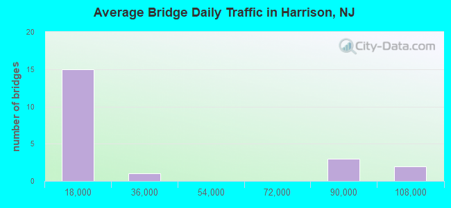
- 508,780Total average daily traffic
- 41,215Total average daily truck traffic
- National Bridge Inventory (NBI) Registered Bridges for Harrison
- No street view available for this location
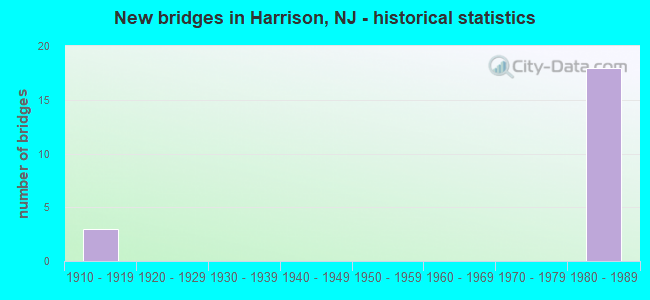
- New bridges - historical statistics
- 31910-1919
- 181980-1989
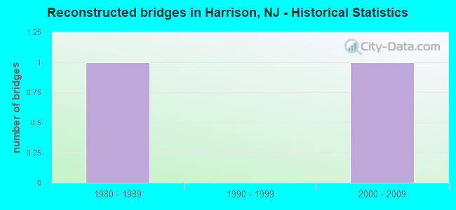
- Reconstructed bridges - Historical Statistics
- 11980-1989
- 01990-1999
- 12000-2009
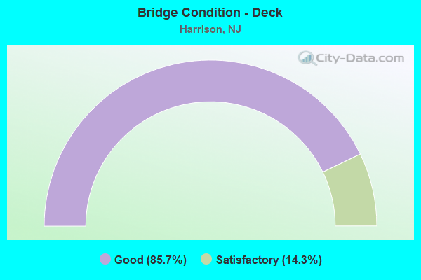
- Bridge Condition - Deck
- 85.7%Good
- 14.3%Satisfactory
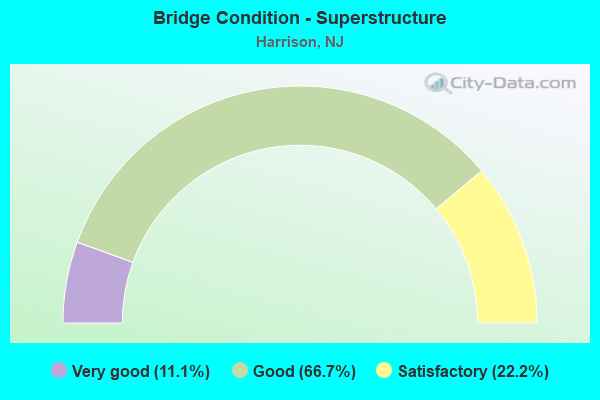
- Bridge Condition - Superstructure
- 11.1%Very good
- 66.7%Good
- 22.2%Satisfactory
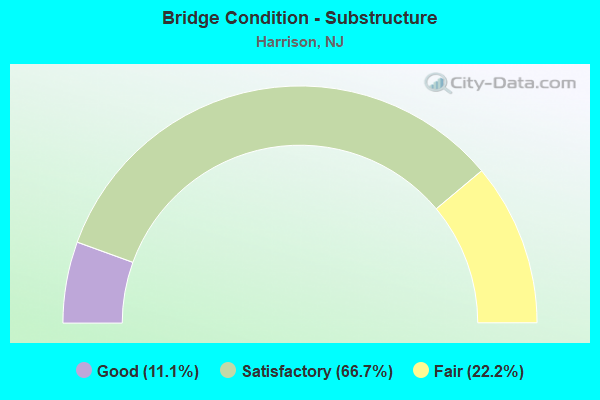
- Bridge Condition - Substructure
- 11.1%Good
- 66.7%Satisfactory
- 22.2%Fair
Find on map >> Show street view
Structure Number: 900019, Location: WEST HUDSON PARK HARRISON (Lat: 40.751811, Lng: -74.148119), Route carried "on" structure: City street , Year Built: 1911, Year Reconstructed: 1991, Status: Open, Structure Length: 2.80m (9.19ft), Average Daily Traffic: 3,058 (year 2021), Truck Traffic: 1%, Average Future Daily Traffic: 3,669 (year 2041), Features Intersected: FAIRY LAKE AND FOOTPATH, Facility Carried by Structure: WOODLAND DRIVE
Minimum Vertical Clearance: 30+ m (98+ ft), Kilometerpoint: 0.000, Lanes on structure: 2, Owner: County Highway Agency, Approaching Roadway Width: 8.5m (27.9ft), Material/Design: Concrete, Design/Construction: Arch - Deck, Number Of Spans In Main Unit: 3, Length of Maximum Span: 18.3m (60.0ft), Curb or Sidewalk Widths: Left: 1.5m (4.9ft), Right: 1.5m (4.9ft), Curb-To-Curb Width: 8.5m (27.9ft), Out-to-Out Width: 12.3m (40.4ft)
Condition: Superstructure: Good, Substructure: Good, Channel: Good, Operating Rating: 39.0 metric tons, Method Used To Determine Operating Rating: Field evaluation and documented engineering judgment, Inventory Rating: 22.7 metric tons, Method Used To Determine Inventory Rating: Field evaluation and documented engineering judgment, Structural Evaluation: Equal to present minimum criteria, Deck Geometry: Meets minimum limits, Waterway Adequacy: Superior to present desirable criteria, Approach Roadway Alignment: Equal to present minimum criteria, Designated Inspection Frequency: Every 24 months, Inspection Date: Febuary 2021
Find on map >> Show street view
Structure Number: 90002, Location: WEST HUDSON PARK HARRISON (Lat: 40.751800, Lng: -74.151781), Route carried "on" structure: City street , Year Built: 1911, Year Reconstructed: 2014, Status: Open, Structure Length: 1.83m (6.00ft), Average Daily Traffic: 3,057 (year 2021), Truck Traffic: 1%, Average Future Daily Traffic: 3,668 (year 2041), Features Intersected: DAVIS AVENUE, Facility Carried by Structure: WOODLAND DRIVE
Minimum Vertical Clearance: 30+ m (98+ ft), Kilometerpoint: 0.000, Lanes on structure: 2, Lanes under structure: 2, Owner: County Highway Agency, Approaching Roadway Width: 8.5m (27.9ft), Material/Design: Concrete, Design/Construction: Arch - Deck, Number Of Spans In Main Unit: 1, Length of Maximum Span: 18.3m (60.0ft), Curb or Sidewalk Widths: Left: 1.8m (5.9ft), Right: 1.9m (6.2ft), Curb-To-Curb Width: 8.5m (27.9ft), Out-to-Out Width: 13.3m (43.6ft)
Condition: Superstructure: Satisfactory, Substructure: Satisfactory, Operating Rating: 36.3 metric tons, Method Used To Determine Operating Rating: Field evaluation and documented engineering judgment, Inventory Rating: 21.8 metric tons, Method Used To Determine Inventory Rating: Field evaluation and documented engineering judgment, Structural Evaluation: Somewhat better than minimum adequacy, Deck Geometry: Meets minimum limits, Underclear: Somewhat better than minimum adequacy, Approach Roadway Alignment: Equal to present minimum criteria, Designated Inspection Frequency: Every 24 months, Inspection Date: Febuary 2021
Find on map >> Show street view
Structure Number: 914156, Location: 0.29 MI E OF RT 21 JCT (Lat: 40.747061, Lng: -74.162800), Route carried "on" structure: Ramp Interstate 280, Year Built: 1980, Status: Open, Structure Length: 2.32m (7.61ft), Average Daily Traffic: 19,300 (year 2021), Truck Traffic: 5%, Average Future Daily Traffic: 23,200 (year 2041), Design Load: HS 20+Mod, Features Intersected: HAMILTON STREET
Minimum Vertical Clearance: 30+ m (98+ ft), Kilometerpoint: 23.673, Lanes on structure: 2, Lanes under structure: 2, Owner: State Highway Agency, Approaching Roadway Width: 9.0m (29.5ft), Skew: 4 degrees, Material/Design: Steel, Design/Construction: Stringer/Multi-beam, Number Of Spans In Main Unit: 1, Length of Maximum Span: 21.0m (68.9ft), Curb-To-Curb Width: 9.0m (29.5ft), Out-to-Out Width: 10.1m (33.1ft)
Condition: Deck: Good, Superstructure: Very good, Substructure: Satisfactory, Inventory Rating: 60.8 metric tons, Method Used To Determine Inventory Rating: Load Factor (LF), Structural Evaluation: Equal to present minimum criteria, Deck Geometry: Meets minimum limits, Underclear: Equal to present minimum criteria, Approach Roadway Alignment: Equal to present minimum criteria, Designated Inspection Frequency: Every 24 months, Inspection Date: March 2021, Deck Structure Type: Concrete Cast-file-Place, Wearing Surface/Protective System: Deck Protection: Epoxy Coated Reinforcing
Find on map >> Show street view
Structure Number: 914157, Location: 0.2 MI EAST OF RT 21 JCT. (Lat: 40.747200, Lng: -74.161800), Route carried "on" structure: Ramp Interstate 280, Year Built: 1980, Status: Open, Structure Length: 5.82m (19.09ft), Average Daily Traffic: 11,655 (year 2020), Truck Traffic: 9%, Average Future Daily Traffic: 15,240 (year 2040), Design Load: HS 20+Mod, Features Intersected: HAMILTON STREET
Minimum Vertical Clearance: 30+ m (98+ ft), Kilometerpoint: 23.673, Lanes on structure: 1, Lanes under structure: 2, Owner: State Highway Agency, Approaching Roadway Width: 9.0m (29.5ft), Material/Design: Steel, Design/Construction: Stringer/Multi-beam, Number Of Spans In Main Unit: 2, Length of Maximum Span: 29.3m (96.1ft), Curb-To-Curb Width: 9.0m (29.5ft), Out-to-Out Width: 10.1m (33.1ft)
Condition: Deck: Good, Superstructure: Good, Substructure: Satisfactory, Operating Rating: 63.5 metric tons, Method Used To Determine Operating Rating: Load Factor (LF), Inventory Rating: 38.1 metric tons, Method Used To Determine Inventory Rating: Load Factor (LF), Structural Evaluation: Equal to present minimum criteria, Deck Geometry: Superior to present desirable criteria, Underclear: Meets minimum limits, Approach Roadway Alignment: Better than present minimum criteria, Designated Inspection Frequency: Every 24 months, Critical Feature Inspection Frequency: Every 24 months, Inspection Date: June 2020, Critical Feature Inspection Date: June 2020, Deck Structure Type: Concrete Cast-file-Place, Wearing Surface/Protective System: Wearing Surface: Monolithic Concrete, Deck Protection: Epoxy Coated Reinforcing
Find on map >> Show street view
Structure Number: 914158, Location: .2 MI EAST OF PASSAIC RIV (Lat: 40.747089, Lng: -74.162481), Route carried "on" structure: Interstate 280, Year Built: 1980, Status: Open, Structure Length: 21.34m (70.01ft), Average Daily Traffic: 78,345 (year 2020), Truck Traffic: 9%, Average Future Daily Traffic: 95,595 (year 2040), Design Load: HS 20+Mod, Features Intersected: CITY STREETS
Minimum Vertical Clearance: 30+ m (98+ ft), Kilometerpoint: 23.673, Lanes on structure: 6, Lanes under structure: 8, Base Highway Network: Yes, Owner: State Highway Agency, Approaching Roadway Width: 33.0m (108.3ft), Skew: 39 degrees, Material/Design: Steel, Design/Construction: Stringer/Multi-beam, Number Of Spans In Main Unit: 7, Length of Maximum Span: 43.0m (141.1ft), Curb-To-Curb Width: 33.0m (108.3ft), Out-to-Out Width: 34.9m (114.5ft)
Condition: Deck: Satisfactory, Superstructure: Good, Substructure: Satisfactory, Inventory Rating: 57.2 metric tons, Method Used To Determine Inventory Rating: Load Factor (LF), Structural Evaluation: Equal to present minimum criteria, Deck Geometry: Superior to present desirable criteria, Underclear: Meets minimum limits, Approach Roadway Alignment: Equal to present desirable criteria, Designated Inspection Frequency: Every 24 months, Critical Feature Inspection Frequency: Every 24 months, Inspection Date: August 2020, Critical Feature Inspection Date: August 2020, Deck Structure Type: Concrete Cast-file-Place, Wearing Surface/Protective System: Wearing Surface: Monolithic Concrete, Deck Protection: Epoxy Coated Reinforcing
Find on map >> Show street view
Structure Number: 914159, Location: 0.5 MI EAST OF PASSAIC RI (Lat: 40.744611, Lng: -74.159300), Route carried "on" structure: Interstate 280, Year Built: 1980, Status: Open, Structure Length: 2.29m (7.51ft), Average Daily Traffic: 93,345 (year 2020), Truck Traffic: 9%, Average Future Daily Traffic: 113,900 (year 2040), Design Load: HS 20+Mod, Features Intersected: WARREN STREET
Minimum Vertical Clearance: 30+ m (98+ ft), Kilometerpoint: 24.172, Lanes on structure: 8, Lanes under structure: 2, Base Highway Network: Yes, Owner: State Highway Agency, Approaching Roadway Width: 47.9m (157.2ft), Skew: 34 degrees, Material/Design: Steel, Design/Construction: Stringer/Multi-beam, Number Of Spans In Main Unit: 1, Length of Maximum Span: 21.6m (70.9ft), Curb-To-Curb Width: 47.9m (157.2ft), Out-to-Out Width: 51.5m (169.0ft)
Condition: Deck: Good, Superstructure: Good, Substructure: Satisfactory, Inventory Rating: 58.1 metric tons, Method Used To Determine Inventory Rating: Load Factor (LF), Structural Evaluation: Equal to present minimum criteria, Deck Geometry: Superior to present desirable criteria, Underclear: Equal to present minimum criteria, Approach Roadway Alignment: Equal to present desirable criteria, Designated Inspection Frequency: Every 24 months, Inspection Date: July 2020, Deck Structure Type: Concrete Cast-file-Place, Wearing Surface/Protective System: Wearing Surface: Monolithic Concrete, Deck Protection: Epoxy Coated Reinforcing
Find on map >> Show street view
Structure Number: 91416, Location: 0.5 MI EAST OF PASSAIC RV (Lat: 40.743931, Lng: -74.158331), Route carried "on" structure: Interstate 280, Year Built: 1980, Status: Open, Structure Length: 2.32m (7.61ft), Average Daily Traffic: 90,930 (year 2020), Truck Traffic: 9%, Average Future Daily Traffic: 110,935 (year 2040), Design Load: HS 20+Mod, Features Intersected: SUSSEX STREET
Minimum Vertical Clearance: 30+ m (98+ ft), Kilometerpoint: 24.269, Lanes on structure: 8, Lanes under structure: 2, Base Highway Network: Yes, Owner: State Highway Agency, Approaching Roadway Width: 46.6m (152.9ft), Skew: 34 degrees, Material/Design: Steel, Design/Construction: Stringer/Multi-beam, Number Of Spans In Main Unit: 1, Length of Maximum Span: 22.6m (74.1ft), Curb-To-Curb Width: 46.5m (152.6ft), Out-to-Out Width: 51.6m (169.3ft)
Condition: Deck: Good, Superstructure: Satisfactory, Substructure: Fair, Operating Rating: 89.8 metric tons, Method Used To Determine Operating Rating: Load Factor (LF), Inventory Rating: 58.1 metric tons, Method Used To Determine Inventory Rating: Load Factor (LF), Structural Evaluation: Somewhat better than minimum adequacy, Deck Geometry: Superior to present desirable criteria, Underclear: Somewhat better than minimum adequacy, Approach Roadway Alignment: Equal to present desirable criteria, Designated Inspection Frequency: Every 24 months, Inspection Date: April 2020, Deck Structure Type: Concrete Cast-file-Place, Wearing Surface/Protective System: Wearing Surface: Monolithic Concrete, Deck Protection: Epoxy Coated Reinforcing
Find on map >> Show street view
Structure Number: 914161, Location: 0.6 MI. EAST OF PASSAIC R (Lat: 40.743239, Lng: -74.157431), Route carried "on" structure: Interstate 280, Year Built: 1980, Status: Open, Structure Length: 2.83m (9.28ft), Average Daily Traffic: 79,300 (year 2021), Truck Traffic: 9%, Average Future Daily Traffic: 95,200 (year 2041), Design Load: HS 20+Mod, Features Intersected: BERGEN STREET
Minimum Vertical Clearance: 30+ m (98+ ft), Kilometerpoint: 24.446, Lanes on structure: 7, Lanes under structure: 2, Base Highway Network: Yes, Owner: State Highway Agency, Approaching Roadway Width: 36.6m (120.1ft), Skew: 35 degrees, Material/Design: Steel, Design/Construction: Stringer/Multi-beam, Number Of Spans In Main Unit: 1, Length of Maximum Span: 27.4m (89.9ft), Curb-To-Curb Width: 36.7m (120.4ft), Out-to-Out Width: 38.6m (126.6ft)
Condition: Deck: Good, Superstructure: Good, Substructure: Fair, Inventory Rating: 56.2 metric tons, Method Used To Determine Inventory Rating: Load Factor (LF), Structural Evaluation: Somewhat better than minimum adequacy, Deck Geometry: Superior to present desirable criteria, Underclear: Equal to present minimum criteria, Approach Roadway Alignment: Equal to present desirable criteria, Designated Inspection Frequency: Every 24 months, Inspection Date: March 2021, Deck Structure Type: Concrete Cast-file-Place, Wearing Surface/Protective System: Deck Protection: Epoxy Coated Reinforcing
Find on map >> Show street view
Structure Number: 914162, Location: AT I-280,EXIT-16 (Lat: 40.742600, Lng: -74.155969), Route carried "on" structure: Interstate 280, Year Built: 1980, Status: Open, Structure Length: 20.42m (66.99ft), Average Daily Traffic: 78,580 (year 2020), Truck Traffic: 9%, Average Future Daily Traffic: 95,880 (year 2040), Design Load: HS 20+Mod, Features Intersected: ESSEX,5TH & RODGERS BLVD
Minimum Vertical Clearance: 30+ m (98+ ft), Kilometerpoint: 24.623, Lanes on structure: 6, Lanes under structure: 8, Base Highway Network: Yes, Owner: State Highway Agency, Approaching Roadway Width: 33.0m (108.3ft), Skew: 39 degrees, Material/Design: Steel, Design/Construction: Stringer/Multi-beam, Number Of Spans In Main Unit: 6, Length of Maximum Span: 43.9m (144.0ft), Curb-To-Curb Width: 33.0m (108.3ft), Out-to-Out Width: 34.9m (114.5ft)
Condition: Deck: Good, Superstructure: Good, Substructure: Satisfactory, Inventory Rating: 57.2 metric tons, Method Used To Determine Inventory Rating: Load Factor (LF), Structural Evaluation: Equal to present minimum criteria, Deck Geometry: Superior to present desirable criteria, Underclear: Meets minimum limits, Approach Roadway Alignment: Better than present minimum criteria, Designated Inspection Frequency: Every 24 months, Critical Feature Inspection Frequency: Every 24 months, Inspection Date: August 2020, Critical Feature Inspection Date: August 2020, Deck Structure Type: Concrete Cast-file-Place, Wearing Surface/Protective System: Wearing Surface: Monolithic Concrete, Deck Protection: Epoxy Coated Reinforcing
Find on map >> Show street view
Structure Number: 90002, Location: WEST HUDSON PARK HARRISON (Lat: 40.751800, Lng: -74.151781), Route carried "under" structure: City street , Year Built: 1911, Structure Length: 0. m, Average Daily Traffic: 5,410 (year 2021), Truck Traffic: 3%, Features Intersected: DAVIS AVENUE, Facility Carried by Structure: WOODLAND DRIVE
Minimum Vertical Clearance: 4.44m (14.57ft), Kilometerpoint: 0.531, Lanes on structure: 2, Lanes under structure: 2, Material/Design: Concrete, Design/Construction: Arch - Deck, Length of Maximum Span: 18.3m (60.0ft)
Find on map >> Show street view
Structure Number: 914156, Location: 0.29 MI E OF RT 21 JCT (Lat: 40.747061, Lng: -74.162800), Route carried "under" structure: City street , Year Built: 1980, Structure Length: 0. m, Average Daily Traffic: 590 (year 2021), Truck Traffic: 3%, Features Intersected: HAMILTON STREET, Facility Carried by Structure: I-280 RAMP "A"
Minimum Vertical Clearance: 4.62m (15.16ft), Kilometerpoint: 1.497, Lanes on structure: 2, Lanes under structure: 2, Material/Design: Steel, Design/Construction: Stringer/Multi-beam, Length of Maximum Span: 21.0m (68.9ft)
Find on map >> Show street view
Structure Number: 914157, Location: 0.2 MI EAST OF RT 21 JCT. (Lat: 40.747200, Lng: -74.161800), Route carried "under" structure: City street , Year Built: 1980, Structure Length: 0. m, Average Daily Traffic: 1,655 (year 2020), Truck Traffic: 3%, Features Intersected: HAMILTON STREET, Facility Carried by Structure: I-280 WB RAMP B
Minimum Vertical Clearance: 4.72m (15.49ft), Kilometerpoint: 1.497, Lanes on structure: 1, Lanes under structure: 2, Material/Design: Steel, Design/Construction: Stringer/Multi-beam, Length of Maximum Span: 29.3m (96.1ft)
Find on map >> Show street view
Structure Number: 914158, Location: .2 MI EAST OF PASSAIC RIV (Lat: 40.747089, Lng: -74.162481), Route carried "under" structure: City street , Year Built: 1980, Structure Length: 0. m, Average Daily Traffic: 2,040 (year 2020), Truck Traffic: 1%, Features Intersected: CITY STREETS, Facility Carried by Structure: I-280
Minimum Vertical Clearance: 4.57m (14.99ft), Kilometerpoint: 0.000, Lanes on structure: 6, Lanes under structure: 3, Material/Design: Steel, Design/Construction: Stringer/Multi-beam, Length of Maximum Span: 43.0m (141.1ft)
Find on map >> Show street view
Structure Number: 914158, Location: .2 MI EAST OF PASSAIC RIV (Lat: 40.747089, Lng: -74.162481), Route carried "under" structure: City street , Year Built: 1980, Structure Length: 0. m, Average Daily Traffic: 1,360 (year 2020), Truck Traffic: 1%, Features Intersected: CITY STREETS, Facility Carried by Structure: I-280
Minimum Vertical Clearance: 4.80m (15.75ft), Kilometerpoint: 1.465, Lanes on structure: 6, Lanes under structure: 2, Material/Design: Steel, Design/Construction: Stringer/Multi-beam, Length of Maximum Span: 43.0m (141.1ft)
Find on map >> Show street view
Structure Number: 914158, Location: .2 MI EAST OF PASSAIC RIV (Lat: 40.747089, Lng: -74.162481), Route carried "under" structure: County highway 508, Year Built: 1980, Structure Length: 0. m, Average Daily Traffic: 10,400 (year 2020), Truck Traffic: 4%, Features Intersected: CITY STREETS, Facility Carried by Structure: I-280
Minimum Vertical Clearance: 6.04m (19.82ft), Kilometerpoint: 20.197, Lanes on structure: 6, Lanes under structure: 3, Material/Design: Steel, Design/Construction: Stringer/Multi-beam, Length of Maximum Span: 43.0m (141.1ft)
Find on map >> Show street view
Structure Number: 914159, Location: 0.5 MI EAST OF PASSAIC RI (Lat: 40.744611, Lng: -74.159300), Route carried "under" structure: City street , Year Built: 1980, Structure Length: 0. m, Average Daily Traffic: 910 (year 2020), Truck Traffic: 1%, Features Intersected: WARREN STREET, Facility Carried by Structure: I-280 & RAMPS E&F
Minimum Vertical Clearance: 4.70m (15.42ft), Kilometerpoint: 0.000, Lanes on structure: 8, Lanes under structure: 2, Material/Design: Steel, Design/Construction: Stringer/Multi-beam, Length of Maximum Span: 21.6m (70.9ft)
Find on map >> Show street view
Structure Number: 91416, Location: 0.5 MI EAST OF PASSAIC RV (Lat: 40.743931, Lng: -74.158331), Route carried "under" structure: City street , Year Built: 1980, Structure Length: 0. m, Average Daily Traffic: 955 (year 2020), Truck Traffic: 1%, Features Intersected: SUSSEX STREET, Facility Carried by Structure: I-280 & RAMPS E&F
Minimum Vertical Clearance: 4.70m (15.42ft), Kilometerpoint: 0.000, Lanes on structure: 8, Lanes under structure: 2, Material/Design: Steel, Design/Construction: Stringer/Multi-beam, Length of Maximum Span: 22.6m (74.1ft)
Find on map >> Show street view
Structure Number: 914161, Location: 0.6 MI. EAST OF PASSAIC R (Lat: 40.743239, Lng: -74.157431), Route carried "under" structure: City street , Year Built: 1980, Structure Length: 0. m, Average Daily Traffic: 1,460 (year 2021), Truck Traffic: 1%, Features Intersected: BERGEN STREET, Facility Carried by Structure: I-280
Minimum Vertical Clearance: 4.42m (14.50ft), Kilometerpoint: 0.000, Lanes on structure: 7, Lanes under structure: 2, Material/Design: Steel, Design/Construction: Stringer/Multi-beam, Length of Maximum Span: 27.4m (89.9ft)
Find on map >> Show street view
Structure Number: 914162, Location: AT I-280,EXIT-16 (Lat: 40.742600, Lng: -74.155969), Route carried "under" structure: City street , Year Built: 1980, Structure Length: 0. m, Average Daily Traffic: 280 (year 2020), Truck Traffic: 1%, Features Intersected: ESSEX,5TH & RODGERS BLVD, Facility Carried by Structure: RT I-280
Minimum Vertical Clearance: 4.39m (14.40ft), Kilometerpoint: 0.000, Lanes on structure: 6, Lanes under structure: 2, Material/Design: Steel, Design/Construction: Stringer/Multi-beam, Length of Maximum Span: 43.9m (144.0ft)
Find on map >> Show street view
Structure Number: 914162, Location: AT I-280,EXIT-16 (Lat: 40.742600, Lng: -74.155969), Route carried "under" structure: City street , Year Built: 1980, Structure Length: 0. m, Average Daily Traffic: 9,785 (year 2020), Truck Traffic: 1%, Features Intersected: ESSEX,5TH & RODGERS BLVD, Facility Carried by Structure: RT I-280
Minimum Vertical Clearance: 4.95m (16.24ft), Kilometerpoint: 0.000, Lanes on structure: 6, Lanes under structure: 2, Material/Design: Steel, Design/Construction: Stringer/Multi-beam, Length of Maximum Span: 43.9m (144.0ft)
Find on map >> Show street view
Structure Number: 914162, Location: AT I-280,EXIT-16 (Lat: 40.742600, Lng: -74.155969), Route carried "under" structure: County highway 697, Year Built: 1980, Structure Length: 0. m, Average Daily Traffic: 16,365 (year 2020), Truck Traffic: 3%, Features Intersected: ESSEX,5TH & RODGERS BLVD, Facility Carried by Structure: RT I-280
Minimum Vertical Clearance: 4.65m (15.26ft), Kilometerpoint: 1.046, Lanes on structure: 6, Lanes under structure: 4, Material/Design: Steel, Design/Construction: Stringer/Multi-beam, Length of Maximum Span: 43.9m (144.0ft)