Bridge Statistics for Harrison Township, Pennsylvania (PA)
Condition, Traffic, Stress, Structural Evaluation, Project Costs
- National Bridge Inventory (NBI) Statistics
- 17Number of bridges
- 131ft / 40.4mTotal length
- $198,000Total costs
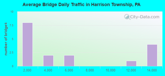
- 86,609Total average daily traffic
- 9,042Total average daily truck traffic
- National Bridge Inventory (NBI) Registered Bridges for Harrison Township
- No street view available for this location
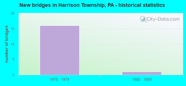
- New bridges - historical statistics
- 161970-1979
- 11980-1989
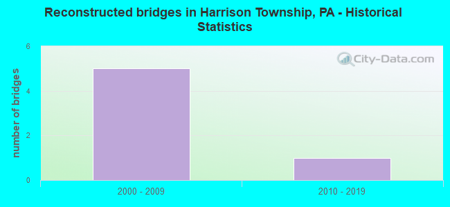
- Reconstructed bridges - Historical Statistics
- 52000-2009
- 12010-2019
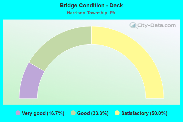
- Bridge Condition - Deck
- 16.7%Very good
- 33.3%Good
- 50.0%Satisfactory
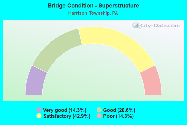
- Bridge Condition - Superstructure
- 14.3%Very good
- 28.6%Good
- 42.9%Satisfactory
- 14.3%Poor
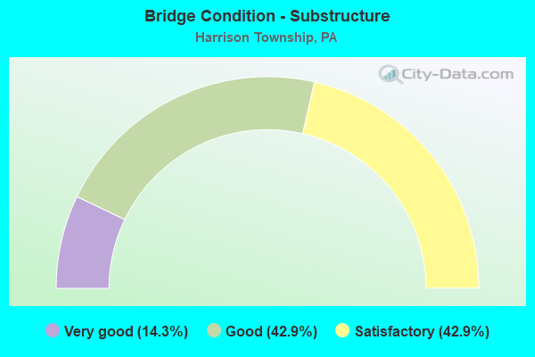
- Bridge Condition - Substructure
- 14.3%Very good
- 42.9%Good
- 42.9%Satisfactory
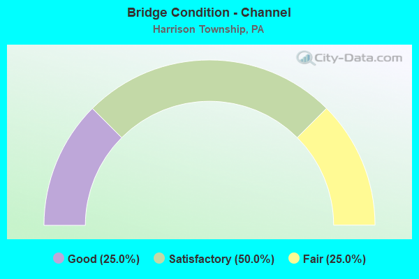
- Bridge Condition - Channel
- 25.0%Good
- 50.0%Satisfactory
- 25.0%Fair
Find on map >> Show street view
Structure Number: 652, Location: @ INT W/ SR 1032 (Lat: 40.631481, Lng: -79.732039), Route carried "on" structure: State highway 28, Year Built: 1972, Year Reconstructed: 2005, Status: Open, Structure Length: 4.66m (15.29ft), Average Daily Traffic: 12,393 (year 2020), Truck Traffic: 15%, Average Future Daily Traffic: 11,897 (year 2032), Design Load: HS 20, Features Intersected: BURTNER ROAD (SR 1032)
Minimum Vertical Clearance: 30+ m (98+ ft), Kilometerpoint: 33.173, Lanes on structure: 2, Lanes under structure: 6, Base Highway Network: Yes, Owner: State Highway Agency, Approaching Roadway Width: 12.2m (40.0ft), Skew: 10 degrees, Material/Design: Prestressed concrete, Design/Construction: Stringer/Multi-beam, Number Of Spans In Main Unit: 3, Length of Maximum Span: 25.6m (84.0ft), Curb or Sidewalk Widths: Left: 0.2m (0.7ft), Right: 0.2m (0.7ft), Curb-To-Curb Width: 12.2m (40.0ft), Out-to-Out Width: 13.4m (44.0ft)
Condition: Deck: Satisfactory, Superstructure: Good, Substructure: Good, Operating Rating: 62.6 metric tons, Method Used To Determine Operating Rating: Load Factor (LF), Inventory Rating: 24.5 metric tons, Method Used To Determine Inventory Rating: Load Factor (LF), Structural Evaluation: Equal to present minimum criteria, Deck Geometry: Better than present minimum criteria, Underclear: Equal to present minimum criteria, Approach Roadway Alignment: Equal to present desirable criteria, Length Of Structure Improvement: 4.70m (15.42ft), Designated Inspection Frequency: Every 24 months, Inspection Date: June 2021, Deck Structure Type: Concrete Cast-file-Place, Wearing Surface/Protective System: Wearing Surface: Latex Concrete
Find on map >> Show street view
Structure Number: 653, Location: @ INT W/ SR 1032 (Lat: 40.631522, Lng: -79.732406), Route carried "on" structure: State highway 28, Year Built: 1972, Year Reconstructed: 2005, Status: Open, Structure Length: 4.66m (15.29ft), Average Daily Traffic: 12,654 (year 2020), Truck Traffic: 11%, Average Future Daily Traffic: 11,660 (year 2032), Design Load: HS 20, Features Intersected: BURTNER ROAD (SR1032)
Minimum Vertical Clearance: 30+ m (98+ ft), Kilometerpoint: 33.130, Lanes on structure: 2, Lanes under structure: 6, Base Highway Network: Yes, Owner: State Highway Agency, Approaching Roadway Width: 12.2m (40.0ft), Skew: 10 degrees, Material/Design: Prestressed concrete, Design/Construction: Stringer/Multi-beam, Number Of Spans In Main Unit: 3, Length of Maximum Span: 25.9m (85.0ft), Curb or Sidewalk Widths: Left: 0.2m (0.7ft), Right: 0.2m (0.7ft), Curb-To-Curb Width: 12.2m (40.0ft), Out-to-Out Width: 13.4m (44.0ft)
Condition: Deck: Satisfactory, Superstructure: Good, Substructure: Good, Operating Rating: 61.7 metric tons, Method Used To Determine Operating Rating: Load Factor (LF), Inventory Rating: 26.3 metric tons, Method Used To Determine Inventory Rating: Load Factor (LF), Structural Evaluation: Equal to present minimum criteria, Deck Geometry: Better than present minimum criteria, Underclear: Meets minimum limits, Approach Roadway Alignment: Equal to present desirable criteria, Length Of Structure Improvement: 4.70m (15.42ft), Designated Inspection Frequency: Every 24 months, Inspection Date: June 2021, Deck Structure Type: Concrete Cast-file-Place, Wearing Surface/Protective System: Wearing Surface: Latex Concrete
Find on map >> Show street view
Structure Number: 654, Location: 1 MI S OF FREEPORT INTCH (Lat: 40.653119, Lng: -79.724742), Route carried "on" structure: State highway 28, Year Built: 1972, Year Reconstructed: 2005, Status: Open, Structure Length: 10.33m (33.89ft), Average Daily Traffic: 12,393 (year 2020), Truck Traffic: 15%, Average Future Daily Traffic: 11,897 (year 2032), Design Load: HS 20, Features Intersected: SAXONBURG RD
Minimum Vertical Clearance: 30+ m (98+ ft), Kilometerpoint: 35.925, Lanes on structure: 2, Lanes under structure: 2, Base Highway Network: Yes, Owner: State Highway Agency, Approaching Roadway Width: 11.9m (39.0ft), Skew: 14 degrees, Material/Design: Steel continuous, Design/Construction: Stringer/Multi-beam, Number Of Spans In Main Unit: 4, Length of Maximum Span: 28.0m (91.9ft), Curb or Sidewalk Widths: Left: 0.2m (0.7ft), Right: 0.2m (0.7ft), Curb-To-Curb Width: 11.9m (39.0ft), Out-to-Out Width: 13.2m (43.3ft)
Condition: Deck: Good, Superstructure: Satisfactory, Substructure: Satisfactory, Channel: Satisfactory, Operating Rating: 68.0 metric tons, Method Used To Determine Operating Rating: Load Factor (LF), Inventory Rating: 40.8 metric tons, Method Used To Determine Inventory Rating: Load Factor (LF), Structural Evaluation: Equal to present minimum criteria, Deck Geometry: Equal to present minimum criteria, Underclear: Equal to present minimum criteria, Waterway Adequacy: Superior to present desirable criteria, Approach Roadway Alignment: Equal to present desirable criteria, Length Of Structure Improvement: 10.30m (33.79ft), Designated Inspection Frequency: Every 24 months, Inspection Date: June 2021, Deck Structure Type: Concrete Cast-file-Place, Wearing Surface/Protective System: Wearing Surface: Latex Concrete
Find on map >> Show street view
Structure Number: 655, Location: 1 MI S OF FREEPORT INTCH (Lat: 40.653522, Lng: -79.725083), Route carried "on" structure: State highway 28, Year Built: 1972, Year Reconstructed: 2005, Status: Open, Structure Length: 11.13m (36.52ft), Average Daily Traffic: 12,654 (year 2020), Truck Traffic: 11%, Average Future Daily Traffic: 11,660 (year 2032), Design Load: HS 25 or greater, Features Intersected: SAXONBURG RD
Minimum Vertical Clearance: 30+ m (98+ ft), Kilometerpoint: 35.888, Lanes on structure: 2, Lanes under structure: 2, Base Highway Network: Yes, Owner: State Highway Agency, Approaching Roadway Width: 11.9m (39.0ft), Skew: 14 degrees, Material/Design: Steel continuous, Design/Construction: Stringer/Multi-beam, Number Of Spans In Main Unit: 4, Length of Maximum Span: 32.6m (107.0ft), Curb or Sidewalk Widths: Left: 0.2m (0.7ft), Right: 0.2m (0.7ft), Curb-To-Curb Width: 11.9m (39.0ft), Out-to-Out Width: 13.2m (43.3ft)
Condition: Deck: Satisfactory, Superstructure: Satisfactory, Substructure: Satisfactory, Channel: Good, Operating Rating: 50.8 metric tons, Method Used To Determine Operating Rating: Load Factor (LF), Inventory Rating: 29.9 metric tons, Method Used To Determine Inventory Rating: Load Factor (LF), Structural Evaluation: Equal to present minimum criteria, Deck Geometry: Equal to present minimum criteria, Underclear: Equal to present minimum criteria, Waterway Adequacy: Superior to present desirable criteria, Approach Roadway Alignment: Equal to present desirable criteria, Length Of Structure Improvement: 11.10m (36.42ft), Designated Inspection Frequency: Every 24 months, Inspection Date: June 2021, Deck Structure Type: Concrete Cast-file-Place, Wearing Surface/Protective System: Wearing Surface: Latex Concrete
Find on map >> Show street view
Structure Number: 657, Location: BAKERSTOWN INTERCHANGE (Lat: 40.667439, Lng: -79.715636), Route carried "on" structure: State highway 28, Year Built: 1972, Year Reconstructed: 2005, Status: Open, Structure Length: 6.71m (22.01ft), Average Daily Traffic: 10,957 (year 2022), Truck Traffic: 7%, Average Future Daily Traffic: 14,055 (year 2032), Design Load: HS 25 or greater, Features Intersected: SR 1028 BAKERSTOWN ROAD
Minimum Vertical Clearance: 30+ m (98+ ft), Kilometerpoint: 38.291, Lanes on structure: 2, Lanes under structure: 8, Base Highway Network: Yes, Owner: State Highway Agency, Approaching Roadway Width: 12.2m (40.0ft), Skew: 11 degrees, Material/Design: Steel, Design/Construction: Stringer/Multi-beam, Number Of Spans In Main Unit: 1, Number Of Approach Spans: 2, Length of Maximum Span: 38.1m (125.0ft), Curb or Sidewalk Widths: Left: 0.2m (0.7ft), Right: 0.2m (0.7ft), Curb-To-Curb Width: 12.2m (40.0ft), Out-to-Out Width: 13.4m (44.0ft)
Condition: Deck: Good, Superstructure: Satisfactory, Substructure: Good, Operating Rating: 70.8 metric tons, Method Used To Determine Operating Rating: Load Factor (LF), Inventory Rating: 41.7 metric tons, Method Used To Determine Inventory Rating: Load Factor (LF), Structural Evaluation: Equal to present minimum criteria, Deck Geometry: Better than present minimum criteria, Underclear: Equal to present minimum criteria, Approach Roadway Alignment: Equal to present desirable criteria, Length Of Structure Improvement: 6.70m (21.98ft), Designated Inspection Frequency: Every 24 months, Inspection Date: June 2021, Deck Structure Type: Concrete Cast-file-Place, Wearing Surface/Protective System: Wearing Surface: Latex Concrete
Find on map >> Show street view
Structure Number: 1447, Location: 3/4 MI SE OF SR 1032 (Lat: 40.623075, Lng: -79.741489), Route carried "on" structure: State highway , Year Built: 1984, Year Reconstructed: 2019, Status: Open, Structure Length: 1.43m (4.69ft), Average Daily Traffic: 984 (year 2022), Truck Traffic: 3%, Average Future Daily Traffic: 1,131 (year 2032), Design Load: HL 93, Features Intersected: LITTLE BULL CREEK, Facility Carried by Structure: PLEASANTVILLE ROAD
Minimum Vertical Clearance: 30+ m (98+ ft), Kilometerpoint: 0.832, Lanes on structure: 2, Owner: State Highway Agency, Approaching Roadway Width: 9.1m (29.9ft), Skew: 4 degrees, Material/Design: Steel, Design/Construction: Stringer/Multi-beam, Number Of Spans In Main Unit: 1, Length of Maximum Span: 13.4m (44.0ft), Curb-To-Curb Width: 9.1m (29.9ft), Out-to-Out Width: 10.1m (33.1ft)
Condition: Deck: Very good, Superstructure: Very good, Substructure: Very good, Channel: Satisfactory, Operating Rating: 59.3 metric tons, Method Used To Determine Operating Rating: Assigned ratings based on Load and Resistance Factor Design (LRFD) reported by rating factor (RF) using HL93 loadings, Inventory Rating: 45.7 metric tons, Method Used To Determine Inventory Rating: Assigned ratings based on Load and Resistance Factor Design (LRFD) reported by rating factor (RF) using HL93 loadings, Structural Evaluation: Equal to present desirable criteria, Deck Geometry: Equal to present minimum criteria, Waterway Adequacy: Superior to present desirable criteria, Approach Roadway Alignment: Better than present minimum criteria, Length Of Structure Improvement: 1.40m (4.59ft), Designated Inspection Frequency: Every 24 months, Inspection Date: January 2021, Deck Structure Type: Concrete Cast-file-Place, Wearing Surface/Protective System: Wearing Surface: Monolithic Concrete, Deck Protection: Epoxy Coated Reinforcing
Find on map >> Show street view
Structure Number: 1448, Location: 1/4 MI. S.W. OF SR 1032 (Lat: 40.628925, Lng: -79.733981), Route carried "on" structure: State highway , Year Built: 1972, Status: Open, Structure Length: 1.46m (4.79ft), Average Daily Traffic: 984 (year 2022), Truck Traffic: 3%, Average Future Daily Traffic: 1,131 (year 2032), Design Load: HS 20, Features Intersected: LITTLE BULL CREEK, Facility Carried by Structure: PLEASANTVILLE ROAD
Minimum Vertical Clearance: 30+ m (98+ ft), Kilometerpoint: 1.362, Lanes on structure: 2, Owner: State Highway Agency, Approaching Roadway Width: 9.4m (30.8ft), Skew: 4 degrees, Material/Design: Prestressed concrete, Design/Construction: Box Beam or Girders - Multiple, Number Of Spans In Main Unit: 1, Length of Maximum Span: 13.7m (44.9ft)
Condition: Superstructure: Poor, Substructure: Satisfactory, Channel: Fair, Inventory Rating: 16.3 metric tons, Method Used To Determine Inventory Rating: Load Factor (LF), Structural Evaluation: Meets minimum limits, Waterway Adequacy: Equal to present desirable criteria, Approach Roadway Alignment: Equal to present desirable criteria, Length Of Structure Improvement: 1.50m (4.92ft), Designated Inspection Frequency: Every 24 months, Inspection Date: January 2021, Bridge Improvement Cost: $15,000, Roadway Improvement Cost: $43,000, Total Project Cost: $198,000
Find on map >> Show street view
Structure Number: 652, Location: @ INT W/ SR 1032 (Lat: 40.631481, Lng: -79.732039), Route carried "under" structure: State highway , Year Built: 1972, Structure Length: 0. m, Average Daily Traffic: 567 (year 2022), Truck Traffic: 1%, Features Intersected: BURTNER ROAD (SR 1032), Facility Carried by Structure: RT 0028 NB
Minimum Vertical Clearance: 4.70m (15.42ft), Kilometerpoint: 2.395, Lanes on structure: 2, Lanes under structure: 3, Material/Design: Prestressed concrete, Design/Construction: Stringer/Multi-beam, Length of Maximum Span: 25.6m (84.0ft)
Find on map >> Show street view
Structure Number: 653, Location: @ INT W/ SR 1032 (Lat: 40.631522, Lng: -79.732406), Route carried "under" structure: State highway , Year Built: 1972, Structure Length: 0. m, Average Daily Traffic: 567 (year 2022), Truck Traffic: 1%, Features Intersected: BURTNER ROAD (SR1032), Facility Carried by Structure: RT 0028 NB
Minimum Vertical Clearance: 4.52m (14.83ft), Kilometerpoint: 2.395, Lanes on structure: 2, Lanes under structure: 3, Material/Design: Prestressed concrete, Design/Construction: Stringer/Multi-beam, Length of Maximum Span: 25.9m (85.0ft)
Find on map >> Show street view
Structure Number: 653, Location: @ INT W/ SR 1032 (Lat: 40.631522, Lng: -79.732406), Route carried "under" structure: State highway , Year Built: 1972, Structure Length: 0. m, Average Daily Traffic: 567 (year 2022), Truck Traffic: 1%, Features Intersected: BURTNER ROAD (SR1032), Facility Carried by Structure: RT 0028 NB
Minimum Vertical Clearance: 4.37m (14.34ft), Kilometerpoint: 2.395, Lanes on structure: 2, Lanes under structure: 3, Material/Design: Prestressed concrete, Design/Construction: Stringer/Multi-beam, Length of Maximum Span: 25.9m (85.0ft)
Find on map >> Show street view
Structure Number: 654, Location: 1 MI S OF FREEPORT INTCH (Lat: 40.653119, Lng: -79.724742), Route carried "under" structure: State highway , Year Built: 1972, Structure Length: 0. m, Average Daily Traffic: 1,972 (year 2021), Truck Traffic: 14%, Features Intersected: SAXONBURG RD, Facility Carried by Structure: SR 28 NB
Minimum Vertical Clearance: 4.50m (14.76ft), Kilometerpoint: 2.177, Lanes on structure: 2, Lanes under structure: 2, Material/Design: Steel continuous, Design/Construction: Stringer/Multi-beam, Length of Maximum Span: 28.0m (91.9ft)
Find on map >> Show street view
Structure Number: 655, Location: 1 MI S OF FREEPORT INTCH (Lat: 40.653522, Lng: -79.725083), Route carried "under" structure: State highway , Year Built: 1972, Structure Length: 0. m, Average Daily Traffic: 1,972 (year 2021), Truck Traffic: 14%, Features Intersected: SAXONBURG RD, Facility Carried by Structure: SR 0028 SB
Minimum Vertical Clearance: 6.55m (21.49ft), Kilometerpoint: 2.177, Lanes on structure: 2, Lanes under structure: 2, Material/Design: Steel continuous, Design/Construction: Stringer/Multi-beam, Length of Maximum Span: 32.6m (107.0ft)
Find on map >> Show street view
Structure Number: 656, Location: BAKERSTOWN INTERCHANGE (Lat: 40.667375, Lng: -79.715336), Route carried "under" structure: State highway , Year Built: 1972, Structure Length: 0. m, Average Daily Traffic: 5,351 (year 2022), Truck Traffic: 7%, Features Intersected: SR 1028 BAKERSTOWN ROAD, Facility Carried by Structure: RT 0028 NB
Minimum Vertical Clearance: 5.61m (18.41ft), Kilometerpoint: 20.587, Lanes on structure: 2, Lanes under structure: 4, Material/Design: Steel, Design/Construction: Stringer/Multi-beam, Length of Maximum Span: 38.1m (125.0ft)
Find on map >> Show street view
Structure Number: 656, Location: BAKERSTOWN INTERCHANGE (Lat: 40.667375, Lng: -79.715336), Route carried "under" structure: State highway , Year Built: 1972, Structure Length: 0. m, Average Daily Traffic: 3,338 (year 2022), Truck Traffic: 6%, Features Intersected: SR 1028 BAKERSTOWN ROAD, Facility Carried by Structure: RT 0028 NB
Minimum Vertical Clearance: 5.96m (19.55ft), Kilometerpoint: 20.587, Lanes on structure: 2, Lanes under structure: 4, Material/Design: Steel, Design/Construction: Stringer/Multi-beam, Length of Maximum Span: 38.1m (125.0ft)
Find on map >> Show street view
Structure Number: 657, Location: BAKERSTOWN INTERCHANGE (Lat: 40.667439, Lng: -79.715636), Route carried "under" structure: State highway , Year Built: 1972, Structure Length: 0. m, Average Daily Traffic: 5,351 (year 2022), Truck Traffic: 7%, Features Intersected: SR 1028 BAKERSTOWN ROAD, Facility Carried by Structure: RT 0028 SB
Minimum Vertical Clearance: 4.82m (15.81ft), Kilometerpoint: 20.587, Lanes on structure: 2, Lanes under structure: 4, Material/Design: Steel, Design/Construction: Stringer/Multi-beam, Length of Maximum Span: 38.1m (125.0ft)
Find on map >> Show street view
Structure Number: 657, Location: BAKERSTOWN INTERCHANGE (Lat: 40.667439, Lng: -79.715636), Route carried "under" structure: State highway , Year Built: 1972, Structure Length: 0. m, Average Daily Traffic: 3,338 (year 2022), Truck Traffic: 6%, Features Intersected: SR 1028 BAKERSTOWN ROAD, Facility Carried by Structure: RT 0028 SB
Minimum Vertical Clearance: 5.31m (17.42ft), Kilometerpoint: 20.587, Lanes on structure: 2, Lanes under structure: 4, Material/Design: Steel, Design/Construction: Stringer/Multi-beam, Length of Maximum Span: 38.1m (125.0ft)