Bridge Statistics for Hartland, Connecticut (CT)
Condition, Traffic, Stress, Structural Evaluation, Project Costs
- National Bridge Inventory (NBI) Statistics
- 13Number of bridges
- 79ft / 24.3mTotal length
- $2,342,000Total costs
- 92,814Total average daily traffic
- 4,660Total average daily truck traffic
- 137,913Total future (year 2033) average daily traffic
- National Bridge Inventory (NBI) Registered Bridges for Hartland
- No street view available for this location
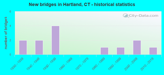
- New bridges - historical statistics
- 21930-1939
- 21940-1949
- 41950-1959
- 11980-1989
- 11990-1999
- 22000-2009
- 12010-2019

- Reconstructed bridges - Historical Statistics
- 21980-1989
- 11990-1999


- Bridge Condition - Deck
- 60.0%Good
- 40.0%Satisfactory

- Bridge Condition - Superstructure
- 41.7%Good
- 50.0%Satisfactory
- 8.3%Fair

- Bridge Condition - Substructure
- 33.3%Good
- 66.7%Satisfactory

- Bridge Condition - Channel
- 90.0%Good
- 10.0%Fair
Find on map >> Show street view
Structure Number: 537, Location: 200' NORTH TOPSTONE ROAD (Lat: 41.300633, Lng: -73.459108), Route carried "on" structure: US 7, Year Built: 1957, Status: Open, Structure Length: 1.34m (4.40ft), Average Daily Traffic: 17,300 (year 2013), Truck Traffic: 6%, Average Future Daily Traffic: 25,706 (year 2033), Design Load: HS 20, Features Intersected: NORWALK RIVER
Minimum Vertical Clearance: 30+ m (98+ ft), Kilometerpoint: 24.365, Lanes on structure: 2, Base Highway Network: Yes, Owner: State Highway Agency, Approaching Roadway Width: 9.8m (32.2ft), Material/Design: Prestressed concrete, Design/Construction: Box Beam or Girders - Multiple, Number Of Spans In Main Unit: 1, Length of Maximum Span: 12.2m (40.0ft), Curb-To-Curb Width: 12.3m (40.4ft), Out-to-Out Width: 14.0m (45.9ft)
Condition: Deck: Good, Superstructure: Satisfactory, Substructure: Satisfactory, Channel: Good, Operating Rating: 31.1 metric tons, Method Used To Determine Operating Rating: Load and Resistance Factor Rating (LRFR) rating reported by rating factor(RF) method using HL-93 loadings, Inventory Rating: 24.0 metric tons, Method Used To Determine Inventory Rating: Load and Resistance Factor Rating (LRFR) rating reported by rating factor(RF) method using HL-93 loadings, Structural Evaluation: Somewhat better than minimum adequacy, Deck Geometry: Somewhat better than minimum adequacy, Waterway Adequacy: Equal to present minimum criteria, Approach Roadway Alignment: Equal to present minimum criteria, Designated Inspection Frequency: Every 24 months, Inspection Date: August 2020, Deck Structure Type: Other, Wearing Surface/Protective System: Wearing Surface: Bituminous, Membrane: Preformed Fabric
Find on map >> Show street view
Structure Number: 558, Location: SOUTH OF BULLS BRIDGE RD. (Lat: 41.673567, Lng: -73.504442), Route carried "on" structure: US 7, Year Built: 1930, Year Reconstructed: 1993, Status: Open, Structure Length: 2.01m (6.59ft), Average Daily Traffic: 2,300 (year 2020), Truck Traffic: 6%, Average Future Daily Traffic: 3,418 (year 2040), Design Load: HS 20, Features Intersected: BULLS CANAL
Minimum Vertical Clearance: 30+ m (98+ ft), Kilometerpoint: 75.108, Lanes on structure: 2, Base Highway Network: Yes, Owner: State Highway Agency, Approaching Roadway Width: 8.8m (28.9ft), Material/Design: Prestressed concrete, Design/Construction: Box Beam or Girders - Multiple, Number Of Spans In Main Unit: 1, Length of Maximum Span: 18.6m (61.0ft), Curb-To-Curb Width: 9.3m (30.5ft), Out-to-Out Width: 10.5m (34.4ft)
Condition: Deck: Good, Superstructure: Good, Substructure: Satisfactory, Channel: Good, Operating Rating: 72.6 metric tons, Method Used To Determine Operating Rating: Load Factor (LF), Inventory Rating: 43.4 metric tons, Method Used To Determine Inventory Rating: Load Factor (LF), Structural Evaluation: Equal to present minimum criteria, Deck Geometry: Meets minimum limits, Waterway Adequacy: Superior to present desirable criteria, Approach Roadway Alignment: Equal to present desirable criteria, Designated Inspection Frequency: Every 24 months, Inspection Date: September 2021, Deck Structure Type: Other, Wearing Surface/Protective System: Wearing Surface: Bituminous, Membrane: Built-up, Deck Protection: Epoxy Coated Reinforcing
Find on map >> Show street view
Structure Number: 568, Location: 0.5 MI S OF ROUTE 110 (Lat: 41.308742, Lng: -73.097036), Route carried "on" structure: State highway 8, Year Built: 1950, Year Reconstructed: 1990, Status: Open, Structure Length: 3.81m (12.50ft), Average Daily Traffic: 60,200 (year 2018), Truck Traffic: 5%, Average Future Daily Traffic: 89,451 (year 2038), Design Load: HS 20, Features Intersected: LONG HILL AVENUE
Minimum Vertical Clearance: 30+ m (98+ ft), Kilometerpoint: 18.942, Lanes on structure: 4, Lanes under structure: 2, Base Highway Network: Yes, Owner: State Highway Agency, Approaching Roadway Width: 22.3m (73.2ft), Skew: 30 degrees, Material/Design: Steel continuous, Design/Construction: Stringer/Multi-beam, Number Of Spans In Main Unit: 3, Length of Maximum Span: 13.4m (44.0ft), Curb-To-Curb Width: 22.3m (73.2ft), Out-to-Out Width: 24.4m (80.1ft)
Condition: Deck: Good, Superstructure: Good, Substructure: Good, Operating Rating: 63.2 metric tons, Method Used To Determine Operating Rating: Load and Resistance Factor Rating (LRFR) rating reported by rating factor(RF) method using HL-93 loadings, Inventory Rating: 48.6 metric tons, Method Used To Determine Inventory Rating: Load and Resistance Factor Rating (LRFR) rating reported by rating factor(RF) method using HL-93 loadings, Structural Evaluation: Better than present minimum criteria, Deck Geometry: Superior to present desirable criteria, Underclear: Meets minimum limits, Approach Roadway Alignment: Equal to present desirable criteria, Designated Inspection Frequency: Every 24 months, Inspection Date: May 2021, Deck Structure Type: Concrete Cast-file-Place, Wearing Surface/Protective System: Wearing Surface: Bituminous, Membrane: Preformed Fabric, Deck Protection: Epoxy Coated Reinforcing
Find on map >> Show street view
Structure Number: 569, Location: 0.1 MI S OF ROUTE 110 (Lat: 41.311628, Lng: -73.090953), Route carried "on" structure: City street , Year Built: 1950, Year Reconstructed: 1991, Status: Open, Structure Length: 2.71m (8.89ft), Average Daily Traffic: 5,355 (year 2021), Truck Traffic: 4%, Average Future Daily Traffic: 7,957 (year 2041), Design Load: HS 20, Features Intersected: ROUTE 8, Facility Carried by Structure: PROSPECT AVENUE
Minimum Vertical Clearance: 30+ m (98+ ft), Kilometerpoint: 0.451, Lanes on structure: 2, Lanes under structure: 4, Owner: State Highway Agency, Approaching Roadway Width: 11.9m (39.0ft), Material/Design: Steel, Design/Construction: Stringer/Multi-beam, Number Of Spans In Main Unit: 1, Length of Maximum Span: 25.6m (84.0ft), Curb or Sidewalk Widths: Left: 1.7m (5.6ft), Right: 1.7m (5.6ft), Curb-To-Curb Width: 11.9m (39.0ft), Out-to-Out Width: 16.1m (52.8ft)
Condition: Deck: Satisfactory, Superstructure: Satisfactory, Substructure: Satisfactory, Operating Rating: 84.5 metric tons, Method Used To Determine Operating Rating: Load Factor (LF), Inventory Rating: 50.8 metric tons, Method Used To Determine Inventory Rating: Load Factor (LF), Structural Evaluation: Equal to present minimum criteria, Deck Geometry: Somewhat better than minimum adequacy, Underclear: High priority of corrective action, Approach Roadway Alignment: Equal to present desirable criteria, Designated Inspection Frequency: Every 24 months, Inspection Date: November 2021, Deck Structure Type: Concrete Cast-file-Place, Wearing Surface/Protective System: Wearing Surface: Bituminous, Membrane: Preformed Fabric, Deck Protection: Epoxy Coated Reinforcing
Find on map >> Show street view
Structure Number: 635, Location: .28MI S OF JCT NB RTE 17 (Lat: 41.554861, Lng: -72.638697), Route carried "on" structure: City street , Year Built: 1958, Status: Open, Structure Length: 4.91m (16.11ft), Average Daily Traffic: 2,509 (year 2019), Truck Traffic: 3%, Average Future Daily Traffic: 3,728 (year 2039), Design Load: HS 20, Features Intersected: ROUTE 9, Facility Carried by Structure: WALNUT STREET
Minimum Vertical Clearance: 30+ m (98+ ft), Kilometerpoint: 0.000, Lanes on structure: 2, Lanes under structure: 5, Owner: State Highway Agency, Approaching Roadway Width: 9.1m (29.9ft), Skew: 2 degrees, Material/Design: Steel, Design/Construction: Stringer/Multi-beam, Number Of Spans In Main Unit: 2, Length of Maximum Span: 26.5m (86.9ft), Curb or Sidewalk Widths: Left: 0.5m (1.6ft), Right: 1.5m (4.9ft), Curb-To-Curb Width: 9.1m (29.9ft), Out-to-Out Width: 11.9m (39.0ft)
Condition: Deck: Satisfactory, Superstructure: Fair, Substructure: Satisfactory, Operating Rating: 35.3 metric tons, Method Used To Determine Operating Rating: Load and Resistance Factor Rating (LRFR) rating reported by rating factor(RF) method using HL-93 loadings, Inventory Rating: 27.2 metric tons, Method Used To Determine Inventory Rating: Load and Resistance Factor Rating (LRFR) rating reported by rating factor(RF) method using HL-93 loadings, Structural Evaluation: Somewhat better than minimum adequacy, Deck Geometry: Meets minimum limits, Underclear: High priority of corrective action, Approach Roadway Alignment: Equal to present desirable criteria, Designated Inspection Frequency: Every 24 months, Inspection Date: March 2020, Deck Structure Type: Concrete Cast-file-Place, Wearing Surface/Protective System: Wearing Surface: Bituminous, Membrane: Built-up
Find on map >> Show street view
Structure Number: 876, Location: 3.66 M W OF ROUTE 179 (Lat: 42.034964, Lng: -72.938056), Route carried "on" structure: State highway 20, Year Built: 1940, Status: Open, Structure Length: 1.40m (4.59ft), Average Daily Traffic: 450 (year 2015), Truck Traffic: 2%, Average Future Daily Traffic: 669 (year 2035), Features Intersected: HUBBARD BROOK
Minimum Vertical Clearance: 30+ m (98+ ft), Kilometerpoint: 17.333, Lanes on structure: 2, Owner: State Highway Agency, Approaching Roadway Width: 10.1m (33.1ft), Skew: 2 degrees, Material/Design: Concrete, Design/Construction: Arch - Deck, Number Of Spans In Main Unit: 1, Length of Maximum Span: 14.0m (45.9ft)
Condition: Superstructure: Satisfactory, Substructure: Satisfactory, Channel: Fair, Structural Evaluation: Equal to present minimum criteria, Waterway Adequacy: Superior to present desirable criteria, Approach Roadway Alignment: Equal to present desirable criteria, Designated Inspection Frequency: Every 24 months, Inspection Date: June 2021
Find on map >> Show street view
Structure Number: 5137, Location: 1.2 MI E OF COLEBROOK TL (Lat: 42.021089, Lng: -72.991528), Route carried "on" structure: City street , Year Built: 2000, Status: Open, Structure Length: 0.73m (2.40ft), Average Daily Traffic: 66 (year 2021), Truck Traffic: 7%, Average Future Daily Traffic: 98 (year 2041), Features Intersected: HOWELL BROOK, Facility Carried by Structure: DISH MILL ROAD
Minimum Vertical Clearance: 30+ m (98+ ft), Kilometerpoint: 0.000, Lanes on structure: 2, Owner: Town or Township Highway Agency, Approaching Roadway Width: 7.3m (24.0ft), Skew: 1 degrees, Material/Design: Concrete, Design/Construction: Frame, Number Of Spans In Main Unit: 1, Length of Maximum Span: 7.3m (24.0ft), Curb-To-Curb Width: 7.4m (24.3ft), Out-to-Out Width: 10.6m (34.8ft)
Condition: Superstructure: Satisfactory, Substructure: Satisfactory, Channel: Good, Operating Rating: 63.2 metric tons, Method Used To Determine Operating Rating: Load Factor (LF), Inventory Rating: 37.8 metric tons, Method Used To Determine Inventory Rating: Load Factor (LF), Structural Evaluation: Equal to present minimum criteria, Deck Geometry: Equal to present minimum criteria, Waterway Adequacy: Better than present minimum criteria, Approach Roadway Alignment: Better than present minimum criteria, Designated Inspection Frequency: Every 24 months, Inspection Date: Febuary 2021, Wearing Surface/Protective System: Wearing Surface: Bituminous, Membrane: Built-up
Find on map >> Show street view
Structure Number: 5138, Location: 0.5 MILE NORTH OF SSR 488 (Lat: 42.007983, Lng: -73.003575), Route carried "on" structure: City street , Year Built: 2002, Status: Open, Structure Length: 1.10m (3.61ft), Average Daily Traffic: 395 (year 2021), Truck Traffic: 7%, Average Future Daily Traffic: 587 (year 2041), Design Load: HS 20, Features Intersected: HOWELL BROOK, Facility Carried by Structure: POND HILL ROAD
Minimum Vertical Clearance: 30+ m (98+ ft), Kilometerpoint: 0.000, Lanes on structure: 2, Owner: Town or Township Highway Agency, Approaching Roadway Width: 6.1m (20.0ft), Material/Design: Prestressed concrete, Design/Construction: Slab, Number Of Spans In Main Unit: 1, Length of Maximum Span: 10.4m (34.1ft), Curb-To-Curb Width: 7.9m (25.9ft), Out-to-Out Width: 9.0m (29.5ft)
Condition: Deck: Good, Superstructure: Good, Substructure: Good, Channel: Good, Inventory Rating: 62.8 metric tons, Method Used To Determine Inventory Rating: Load Factor (LF), Structural Evaluation: Better than present minimum criteria, Deck Geometry: Somewhat better than minimum adequacy, Waterway Adequacy: Equal to present minimum criteria, Approach Roadway Alignment: Equal to present desirable criteria, Designated Inspection Frequency: Every 24 months, Inspection Date: Febuary 2021, Deck Structure Type: Other, Wearing Surface/Protective System: Wearing Surface: Bituminous, Membrane: Built-up, Deck Protection: Epoxy Coated Reinforcing
Find on map >> Show street view
Structure Number: 567, Location: 0.6 MILE NORTH OF RTE 202 (Lat: 41.838600, Lng: -73.015011), Route carried "on" structure: State highway 219, Year Built: 1988, Status: Open, Structure Length: 2.56m (8.40ft), Average Daily Traffic: 3,200 (year 2015), Truck Traffic: 3%, Average Future Daily Traffic: 4,755 (year 2035), Design Load: HS 20, Features Intersected: NEPAUG RIVER
Minimum Vertical Clearance: 30+ m (98+ ft), Kilometerpoint: 0.966, Lanes on structure: 2, Owner: State Highway Agency, Approaching Roadway Width: 10.4m (34.1ft), Material/Design: Steel, Design/Construction: Stringer/Multi-beam, Number Of Spans In Main Unit: 1, Length of Maximum Span: 25.0m (82.0ft), Curb-To-Curb Width: 10.4m (34.1ft), Out-to-Out Width: 11.5m (37.7ft)
Condition: Deck: Good, Superstructure: Good, Substructure: Good, Channel: Good, Operating Rating: 98.0 metric tons, Method Used To Determine Operating Rating: Load Factor (LF), Inventory Rating: 58.8 metric tons, Method Used To Determine Inventory Rating: Load Factor (LF), Structural Evaluation: Better than present minimum criteria, Deck Geometry: Somewhat better than minimum adequacy, Waterway Adequacy: Equal to present minimum criteria, Approach Roadway Alignment: Equal to present desirable criteria, Designated Inspection Frequency: Every 48 months, Inspection Date: August 2018, Deck Structure Type: Concrete Cast-file-Place, Wearing Surface/Protective System: Wearing Surface: Bituminous, Membrane: Preformed Fabric, Deck Protection: Epoxy Coated Reinforcing
Find on map >> Show street view
Structure Number: 5893, Location: 3.2 MILES WEST OF RTE 179 (Lat: 42.034294, Lng: -72.929819), Route carried "on" structure: State highway 20, Year Built: 1990, Status: Open, Structure Length: 1.62m (5.31ft), Average Daily Traffic: 450 (year 2015), Truck Traffic: 2%, Average Future Daily Traffic: 669 (year 2035), Design Load: HS 20, Features Intersected: VALLEY BROOK
Minimum Vertical Clearance: 30+ m (98+ ft), Kilometerpoint: 17.992, Lanes on structure: 2, Owner: State Highway Agency, Approaching Roadway Width: 9.4m (30.8ft), Material/Design: Prestressed concrete, Design/Construction: Box Beam or Girders - Multiple, Number Of Spans In Main Unit: 1, Length of Maximum Span: 15.5m (50.9ft), Curb-To-Curb Width: 9.4m (30.8ft), Out-to-Out Width: 10.5m (34.4ft)
Condition: Deck: Good, Superstructure: Good, Substructure: Satisfactory, Channel: Good, Operating Rating: 41.8 metric tons, Method Used To Determine Operating Rating: Load and Resistance Factor Rating (LRFR) rating reported by rating factor(RF) method using HL-93 loadings, Inventory Rating: 32.4 metric tons, Method Used To Determine Inventory Rating: Load and Resistance Factor Rating (LRFR) rating reported by rating factor(RF) method using HL-93 loadings, Structural Evaluation: Equal to present minimum criteria, Deck Geometry: Equal to present minimum criteria, Waterway Adequacy: Superior to present desirable criteria, Approach Roadway Alignment: Superior to present desirable criteria, Designated Inspection Frequency: Every 24 months, Inspection Date: January 2020, Deck Structure Type: Other, Wearing Surface/Protective System: Wearing Surface: Bituminous, Membrane: Built-up, Deck Protection: Epoxy Coated Reinforcing
Find on map >> Show street view
Structure Number: 6176, Location: 0.8 MILE NORTH OF RTE 189 (Lat: 42.034628, Lng: -72.871994), Route carried "on" structure: City street , Year Built: 2018, Status: Open, Structure Length: 0.70m (2.30ft), Average Daily Traffic: 443 (year 2021), Truck Traffic: 7%, Average Future Daily Traffic: 658 (year 2041), Design Load: HL 93, Features Intersected: BROOK, Facility Carried by Structure: PECK ORCHARD ROAD
Minimum Vertical Clearance: 30+ m (98+ ft), Kilometerpoint: 0.000, Lanes on structure: 2, Owner: Town or Township Highway Agency, Approaching Roadway Width: 7.3m (24.0ft), Skew: 5 degrees, Material/Design: Steel, Design/Construction: Culvert, Number Of Spans In Main Unit: 2, Length of Maximum Span: 4.0m (13.1ft), Curb or Sidewalk Widths: Left: 0.7m (2.3ft), Right: 0.7m (2.3ft)
Condition: Channel: Good, Culverts: Good, Operating Rating: 47.3 metric tons, Method Used To Determine Operating Rating: Load and Resistance Factor Rating (LRFR) rating reported by rating factor(RF) method using HL-93 loadings, Inventory Rating: 36.6 metric tons, Method Used To Determine Inventory Rating: Load and Resistance Factor Rating (LRFR) rating reported by rating factor(RF) method using HL-93 loadings, Structural Evaluation: Better than present minimum criteria, Waterway Adequacy: Better than present minimum criteria, Approach Roadway Alignment: Equal to present minimum criteria, Designated Inspection Frequency: Every 24 months, Inspection Date: Febuary 2021, Total Project Cost: $2,342,000
Find on map >> Show street view
Structure Number: 6177, Location: 200' SOUTH OF PEDERSEN RD (Lat: 41.974306, Lng: -72.895539), Route carried "on" structure: City street , Year Built: 1945, Status: Open, Structure Length: 0.67m (2.20ft), Average Daily Traffic: 126 (year 2021), Truck Traffic: 7%, Average Future Daily Traffic: 187 (year 2041), Features Intersected: WEST BRANCH SALMON BROOK, Facility Carried by Structure: DALENE DRIVE
Minimum Vertical Clearance: 30+ m (98+ ft), Kilometerpoint: 0.000, Lanes on structure: 2, Owner: Town or Township Highway Agency, Approaching Roadway Width: 7.3m (24.0ft), Material/Design: Concrete, Design/Construction: Slab, Number Of Spans In Main Unit: 1, Length of Maximum Span: 6.1m (20.0ft), Curb-To-Curb Width: 7.3m (24.0ft), Out-to-Out Width: 8.5m (27.9ft)
Condition: Deck: Satisfactory, Superstructure: Satisfactory, Substructure: Satisfactory, Channel: Good, Operating Rating: 42.6 metric tons, Method Used To Determine Operating Rating: Field evaluation and documented engineering judgment, Inventory Rating: 32.7 metric tons, Method Used To Determine Inventory Rating: Field evaluation and documented engineering judgment, Structural Evaluation: Equal to present minimum criteria, Deck Geometry: Somewhat better than minimum adequacy, Waterway Adequacy: Better than present minimum criteria, Approach Roadway Alignment: Equal to present minimum criteria, Designated Inspection Frequency: Every 24 months, Inspection Date: Febuary 2021, Deck Structure Type: Concrete Cast-file-Place, Wearing Surface/Protective System: Wearing Surface: Bituminous
Find on map >> Show street view
Structure Number: 635, Location: EAST OFF OF ROUTE 20 (Lat: 42.028247, Lng: -72.914117), Route carried "on" structure: State lands road , Year Built: 1934, Status: Open, Structure Length: 0.76m (2.49ft), Average Daily Traffic: 20 (year 2021), Truck Traffic: 5%, Average Future Daily Traffic: 30 (year 2041), Features Intersected: HURRICANE BROOK, Facility Carried by Structure: HURRICANE BROOK RD
Minimum Vertical Clearance: 30+ m (98+ ft), Kilometerpoint: 0.000, Lanes on structure: 1, Owner: State Park, Forest, or Reservation Agency, Approaching Roadway Width: 3.0m (9.8ft), Skew: 4 degrees, Material/Design: Concrete, Design/Construction: Slab, Number Of Spans In Main Unit: 1, Length of Maximum Span: 6.4m (21.0ft), Curb-To-Curb Width: 3.3m (10.8ft), Out-to-Out Width: 3.6m (11.8ft)
Condition: Deck: Satisfactory, Superstructure: Satisfactory, Substructure: Good, Channel: Good, Operating Rating: 42.6 metric tons, Method Used To Determine Operating Rating: Field evaluation and documented engineering judgment, Inventory Rating: 32.7 metric tons, Method Used To Determine Inventory Rating: Field evaluation and documented engineering judgment, Structural Evaluation: Equal to present minimum criteria, Deck Geometry: High priority of replacement, Waterway Adequacy: Equal to present desirable criteria, Approach Roadway Alignment: Equal to present desirable criteria, Designated Inspection Frequency: Every 24 months, Inspection Date: April 2021, Deck Structure Type: Concrete Cast-file-Place, Wearing Surface/Protective System: Wearing Surface: Monolithic Concrete