Bridge Statistics for Harvey, Illinois (IL)
Condition, Traffic, Stress, Structural Evaluation, Project Costs
- National Bridge Inventory (NBI) Statistics
- 18Number of bridges
- 56ft / 17.4mTotal length
- $3,696,000Total costs
- 326,250Total average daily traffic
- 31,176Total average daily truck traffic
- National Bridge Inventory (NBI) Registered Bridges for Harvey
- No street view available for this location
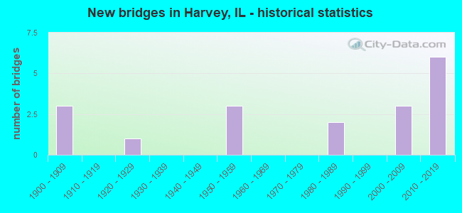
- New bridges - historical statistics
- 31900-1909
- 11920-1929
- 31950-1959
- 21980-1989
- 32000-2009
- 62010-2019

- Reconstructed bridges - Historical Statistics
- 11970-1979
- 01980-1989
- 11990-1999
- 12000-2009


- Bridge Condition - Deck
- 25.0%Good
- 50.0%Satisfactory
- 25.0%Fair

- Bridge Condition - Superstructure
- 20.0%Good
- 40.0%Satisfactory
- 40.0%Fair

- Bridge Condition - Substructure
- 20.0%Very good
- 60.0%Good
- 20.0%Satisfactory

- Bridge Condition - Channel
- 14.3%Excellent
- 71.4%Satisfactory
- 14.3%Fair

- Bridge Condition - Culverts
- 50.0%Good
- 50.0%Satisfactory
Find on map >> Show street view
Structure Number: 160771, Location: 0.5 M S US 6 (Lat: 41.597061, Lng: -87.650158), Route carried "on" structure: Other road , Year Built: 1958, Year Reconstructed: 2013, Status: Open, Structure Length: 1.47m (4.82ft), Average Daily Traffic: 7,800 (year 2021), Truck Traffic: 3%, Average Future Daily Traffic: 5,047 (year 2032), Design Load: HS 20, Features Intersected: CAL UNION DITCH, Facility Carried by Structure: PARK AVE
Minimum Vertical Clearance: 30+ m (98+ ft), Kilometerpoint: 2.623, Lanes on structure: 4, Owner: State Highway Agency, Approaching Roadway Width: 13.5m (44.3ft), Skew: 2 degrees, Material/Design: Prestressed concrete, Design/Construction: Box Beam or Girders - Multiple, Number Of Spans In Main Unit: 1, Length of Maximum Span: 13.7m (44.9ft), Curb or Sidewalk Widths: Left: 0.0m, Right: 1.2m (3.9ft), Curb-To-Curb Width: 13.5m (44.3ft), Out-to-Out Width: 15.8m (51.8ft)
Condition: Deck: Satisfactory, Superstructure: Satisfactory, Substructure: Good, Channel: Satisfactory, Operating Rating: 89.1 metric tons, Method Used To Determine Operating Rating: Load and Resistance Factor Rating (LRFR) rating reported by rating factor(RF) method using HL-93 loadings, Inventory Rating: 77.4 metric tons, Method Used To Determine Inventory Rating: Load and Resistance Factor Rating (LRFR) rating reported by rating factor(RF) method using HL-93 loadings, Structural Evaluation: Equal to present minimum criteria, Deck Geometry: High priority of replacement, Waterway Adequacy: Equal to present desirable criteria, Approach Roadway Alignment: Equal to present desirable criteria, Length Of Structure Improvement: 2.10m (6.89ft), Designated Inspection Frequency: Every 24 months, Inspection Date: Febuary 2021, Bridge Improvement Cost: $307,000, Roadway Improvement Cost: $31,000, Total Project Cost: $461,000, Deck Structure Type: Concrete Cast-file-Place, Wearing Surface/Protective System: Wearing Surface: Integral Concrete, Deck Protection: Epoxy Coated Reinforcing
Find on map >> Show street view
Structure Number: 160954, Location: 1 M E IL 1 (Lat: 41.622619, Lng: -87.627731), Route carried "on" structure: State highway 83, Year Built: 1922, Year Reconstructed: 1984, Status: Open, Structure Length: 5.85m (19.19ft), Average Daily Traffic: 26,100 (year 2021), Truck Traffic: 6%, Average Future Daily Traffic: 30,488 (year 2032), Design Load: HS 20, Features Intersected: LITTLE CAL RIVER
Minimum Vertical Clearance: 30+ m (98+ ft), Kilometerpoint: 19.601, Lanes on structure: 4, Base Highway Network: Yes, Owner: State Highway Agency, Approaching Roadway Width: 13.4m (44.0ft), Material/Design: Steel continuous, Design/Construction: Stringer/Multi-beam, Number Of Spans In Main Unit: 4, Length of Maximum Span: 14.6m (47.9ft), Curb or Sidewalk Widths: Left: 1.5m (4.9ft), Right: 1.5m (4.9ft), Curb-To-Curb Width: 13.4m (44.0ft), Out-to-Out Width: 16.8m (55.1ft)
Condition: Deck: Satisfactory, Superstructure: Fair, Substructure: Good, Channel: Fair, Operating Rating: 69.7 metric tons, Method Used To Determine Operating Rating: Load Factor (LF) rating reported by rating factor (RF) method using MS18 loading, Inventory Rating: 40.2 metric tons, Method Used To Determine Inventory Rating: Load Factor (LF) rating reported by rating factor (RF) method using MS18 loading, Structural Evaluation: Somewhat better than minimum adequacy, Deck Geometry: High priority of replacement, Waterway Adequacy: Equal to present desirable criteria, Approach Roadway Alignment: Equal to present desirable criteria, Length Of Structure Improvement: 8.84m (29.00ft), Designated Inspection Frequency: Every 24 months, Other Special Inspection Frequency: Every 24 months, Inspection Date: June 2020, Other Special Inspection Date: June 2020, Bridge Improvement Cost: $2,025,000, Roadway Improvement Cost: $203,000, Total Project Cost: $3,038,000, Deck Structure Type: Concrete Cast-file-Place, Wearing Surface/Protective System: Wearing Surface: Epoxy Overlay, Deck Protection: Epoxy Coated Reinforcing
Find on map >> Show street view
Structure Number: 162525, Location: @ 161ST .25 M S US6 (Lat: 41.597103, Lng: -87.636422), Route carried "on" structure: State highway 1, Year Built: 1984, Status: Open, Structure Length: 0.79m (2.59ft), Average Daily Traffic: 19,200 (year 2021), Truck Traffic: 9%, Average Future Daily Traffic: 21,836 (year 2032), Design Load: HS 20, Features Intersected: CAL UNION DITCH
Minimum Vertical Clearance: 30+ m (98+ ft), Kilometerpoint: 507.380, Lanes on structure: 4, Base Highway Network: Yes, Owner: State Highway Agency, Approaching Roadway Width: 17.1m (56.1ft), Skew: 20 degrees, Material/Design: Concrete, Design/Construction: Slab, Number Of Spans In Main Unit: 1, Length of Maximum Span: 7.6m (24.9ft), Curb or Sidewalk Widths: Left: 1.5m (4.9ft), Right: 1.5m (4.9ft), Curb-To-Curb Width: 19.5m (64.0ft), Out-to-Out Width: 23.2m (76.1ft)
Condition: Deck: Fair, Superstructure: Fair, Substructure: Satisfactory, Channel: Satisfactory, Operating Rating: 67.7 metric tons, Method Used To Determine Operating Rating: Load Factor (LF) rating reported by rating factor (RF) method using MS18 loading, Inventory Rating: 40.5 metric tons, Method Used To Determine Inventory Rating: Load Factor (LF) rating reported by rating factor (RF) method using MS18 loading, Structural Evaluation: Somewhat better than minimum adequacy, Deck Geometry: Better than present minimum criteria, Waterway Adequacy: Equal to present minimum criteria, Approach Roadway Alignment: Equal to present desirable criteria, Length Of Structure Improvement: 0.73m (2.40ft), Designated Inspection Frequency: Every 24 months, Inspection Date: August 2020, Bridge Improvement Cost: $131,000, Roadway Improvement Cost: $13,000, Total Project Cost: $197,000, Deck Structure Type: Concrete Cast-file-Place, Wearing Surface/Protective System: Wearing Surface: Other, Deck Protection: Epoxy Coated Reinforcing
Find on map >> Show street view
Structure Number: 162723, Location: @ 146TH ST (Lat: 41.629569, Lng: -87.641461), Route carried "on" structure: State highway 1, Year Built: 2001, Year Reconstructed: 2002, Status: Open, Structure Length: 6.52m (21.39ft), Average Daily Traffic: 15,900 (year 2021), Truck Traffic: 6%, Average Future Daily Traffic: 18,128 (year 2032), Design Load: HS 20, Features Intersected: CALUMET RIVER
Minimum Vertical Clearance: 30+ m (98+ ft), Kilometerpoint: 511.017, Lanes on structure: 4, Base Highway Network: Yes, Owner: State Highway Agency, Approaching Roadway Width: 16.4m (53.8ft), Material/Design: Steel continuous, Design/Construction: Stringer/Multi-beam, Number Of Spans In Main Unit: 3, Length of Maximum Span: 24.6m (80.7ft), Curb or Sidewalk Widths: Left: 2.1m (6.9ft), Right: 2.1m (6.9ft), Curb-To-Curb Width: 16.4m (53.8ft), Out-to-Out Width: 21.2m (69.6ft)
Condition: Deck: Good, Superstructure: Good, Substructure: Very good, Channel: Satisfactory, Operating Rating: 89.1 metric tons, Method Used To Determine Operating Rating: Load Factor (LF) rating reported by rating factor (RF) method using MS18 loading, Inventory Rating: 85.2 metric tons, Method Used To Determine Inventory Rating: Load Factor (LF) rating reported by rating factor (RF) method using MS18 loading, Structural Evaluation: Better than present minimum criteria, Deck Geometry: Meets minimum limits, Waterway Adequacy: Superior to present desirable criteria, Approach Roadway Alignment: Equal to present desirable criteria, Designated Inspection Frequency: Every 48 months, Inspection Date: November 2020, Deck Structure Type: Concrete Cast-file-Place, Wearing Surface/Protective System: Deck Protection: Epoxy Coated Reinforcing
Find on map >> Show street view
Structure Number: 162814, Location: 0.2 M S US 6 (Lat: 41.597600, Lng: -87.660747), Route carried "on" structure: Other road , Year Built: 2003, Status: Open, Structure Length: 1.01m (3.31ft), Average Daily Traffic: 7,750 (year 2021), Truck Traffic: 2%, Average Future Daily Traffic: 8,240 (year 2032), Design Load: HS 20, Features Intersected: CAL UNION DITCH, Facility Carried by Structure: WOOD ST
Minimum Vertical Clearance: 30+ m (98+ ft), Kilometerpoint: 8.755, Lanes on structure: 4, Base Highway Network: Yes, Owner: State Highway Agency, Approaching Roadway Width: 14.6m (47.9ft), Material/Design: Concrete, Design/Construction: Frame, Number Of Spans In Main Unit: 1, Length of Maximum Span: 9.6m (31.5ft), Curb or Sidewalk Widths: Left: 3.1m (10.2ft), Right: 3.1m (10.2ft), Curb-To-Curb Width: 14.6m (47.9ft), Out-to-Out Width: 21.5m (70.5ft)
Condition: Superstructure: Satisfactory, Substructure: Good, Channel: Satisfactory, Operating Rating: 44.1 metric tons, Method Used To Determine Operating Rating: Load Factor (LF) rating reported by rating factor (RF) method using MS18 loading, Inventory Rating: 32.4 metric tons, Method Used To Determine Inventory Rating: Load Factor (LF) rating reported by rating factor (RF) method using MS18 loading, Structural Evaluation: Equal to present minimum criteria, Deck Geometry: High priority of replacement, Waterway Adequacy: Superior to present desirable criteria, Approach Roadway Alignment: Equal to present desirable criteria, Designated Inspection Frequency: Every 24 months, Inspection Date: November 2021, Deck Structure Type: Concrete Cast-file-Place
Find on map >> Show street view
Structure Number: 167117, Location: 0.3MI S.OFUS 6 P.24 (Lat: 41.596869, Lng: -87.641294), Route carried "on" structure: City street , Year Built: 1986, Status: Open, Structure Length: 1.07m (3.51ft), Average Daily Traffic: 1,350 (year 2018), Truck Traffic: 10%, Average Future Daily Traffic: 421 (year 2032), Design Load: HS 20+Mod, Features Intersected: CAL-UNION DR.DITCH, Facility Carried by Structure: LATHROP AVE.
Minimum Vertical Clearance: 30+ m (98+ ft), Kilometerpoint: 1.094, Lanes on structure: 2, Owner: City or Municipal Highway Agency, Approaching Roadway Width: 9.4m (30.8ft), Material/Design: Concrete, Design/Construction: Culvert, Number Of Spans In Main Unit: 3, Length of Maximum Span: 3.0m (9.8ft), Curb or Sidewalk Widths: Left: 1.2m (3.9ft), Right: 1.2m (3.9ft), Curb-To-Curb Width: 7.3m (24.0ft), Out-to-Out Width: 10.4m (34.1ft)
Condition: Channel: Satisfactory, Culverts: Satisfactory, Operating Rating: 53.8 metric tons, Method Used To Determine Operating Rating: Field evaluation and documented engineering judgment, Inventory Rating: 32.4 metric tons, Method Used To Determine Inventory Rating: Field evaluation and documented engineering judgment, Structural Evaluation: Equal to present minimum criteria, Deck Geometry: Meets minimum limits, Waterway Adequacy: Superior to present desirable criteria, Approach Roadway Alignment: Equal to present minimum criteria, Designated Inspection Frequency: Every 24 months, Inspection Date: October 2019
Find on map >> Show street view
Structure Number: 167118, Location: 0.25M S 159th St. (Lat: 41.597219, Lng: -87.645089), Route carried "on" structure: Other road , Year Built: 2016, Status: Open, Structure Length: 0.68m (2.23ft), Average Daily Traffic: 3,150 (year 2018), Truck Traffic: 51%, Average Future Daily Traffic: 1,803 (year 2032), Design Load: HS 25 or greater, Features Intersected: HARVEY DR CANAL, Facility Carried by Structure: CENTER ST
Minimum Vertical Clearance: 30+ m (98+ ft), Kilometerpoint: 0.402, Lanes on structure: 2, Base Highway Network: Yes, Owner: County Highway Agency, Approaching Roadway Width: 11.0m (36.1ft), Material/Design: Concrete, Design/Construction: Culvert, Number Of Spans In Main Unit: 2, Length of Maximum Span: 3.3m (10.8ft)
Condition: Channel: Excellent, Culverts: Good, Operating Rating: 79.1 metric tons, Method Used To Determine Operating Rating: Load and Resistance Factor Rating (LRFR) rating reported by rating factor(RF) method using HL-93 loadings, Inventory Rating: 60.9 metric tons, Method Used To Determine Inventory Rating: Load and Resistance Factor Rating (LRFR) rating reported by rating factor(RF) method using HL-93 loadings, Structural Evaluation: Better than present minimum criteria, Waterway Adequacy: Superior to present desirable criteria, Approach Roadway Alignment: Equal to present desirable criteria, Designated Inspection Frequency: Every 48 months, Inspection Date: January 2019
Find on map >> Show street view
Structure Number: 160197, Location: 1 M NW US 6 P24 (Lat: 41.616511, Lng: -87.639231), Route carried "under" structure: State highway 1, Year Built: 1900, Structure Length: 0. m, Average Daily Traffic: 12,400 (year 2021), Truck Traffic: 10%, Features Intersected: VINCENNES AVE, Facility Carried by Structure: IC RR
Minimum Vertical Clearance: 5.23m (17.16ft), Kilometerpoint: 509.504, Lanes under structure: 4, Material/Design: Concrete, Length of Maximum Span: 7.0m (23.0ft)
Find on map >> Show street view
Structure Number: 160953, Location: 0.3 M E ILL 1 P24 (Lat: 41.622611, Lng: -87.635942), Route carried "under" structure: State highway 83, Year Built: 1900, Structure Length: 0. m, Average Daily Traffic: 25,900 (year 2021), Truck Traffic: 6%, Features Intersected: ILL 83 (147TH ST), Facility Carried by Structure: IC RR
Minimum Vertical Clearance: 4.24m (13.91ft), Kilometerpoint: 20.309, Lanes under structure: 4, Material/Design: Steel, Length of Maximum Span: 7.3m (24.0ft)
Find on map >> Show street view
Structure Number: 162754, Location: 0.61 M W IL 1 (Lat: 41.600881, Lng: -87.647250), Route carried "under" structure: US 6, Year Built: 2007, Structure Length: 0. m, Average Daily Traffic: 31,300 (year 2021), Truck Traffic: 9%, Features Intersected: US 6 (159TH ST), Facility Carried by Structure: RR - CN
Minimum Vertical Clearance: 5.08m (16.67ft), Kilometerpoint: 277.411, Lanes under structure: 5, Material/Design: Steel, Design/Construction: Stringer/Multi-beam, Length of Maximum Span: 15.8m (51.8ft)
Find on map >> Show street view
Structure Number: 162755, Location: 0.62 MI W IL-1 (Lat: 41.600881, Lng: -87.647639), Route carried "under" structure: US 6, Year Built: 2010, Structure Length: 0. m, Average Daily Traffic: 31,300 (year 2021), Truck Traffic: 9%, Features Intersected: US 6 (159TH ST), Facility Carried by Structure: RR - METRA & CN
Minimum Vertical Clearance: 4.60m (15.09ft), Kilometerpoint: 277.395, Lanes under structure: 5, Material/Design: Steel, Design/Construction: Stringer/Multi-beam, Length of Maximum Span: 16.4m (53.8ft)
Find on map >> Show street view
Structure Number: 162819, Location: 0.58 M W IL 1 (Lat: 41.600881, Lng: -87.646861), Route carried "under" structure: US 6, Year Built: 2010, Structure Length: 0. m, Average Daily Traffic: 31,300 (year 2021), Truck Traffic: 9%, Features Intersected: US 6 (159TH ST), Facility Carried by Structure: RR - CN
Minimum Vertical Clearance: 4.65m (15.26ft), Kilometerpoint: 277.427, Lanes under structure: 4, Material/Design: Steel, Design/Construction: Stringer/Multi-beam, Length of Maximum Span: 16.2m (53.1ft)
Find on map >> Show street view
Structure Number: 16282, Location: 0.56 M W IL 1 (Lat: 41.600881, Lng: -87.646531), Route carried "under" structure: US 6, Year Built: 2010, Structure Length: 0. m, Average Daily Traffic: 31,300 (year 2021), Truck Traffic: 9%, Features Intersected: US 6 (159TH ST), Facility Carried by Structure: RR - CN (ACCESS RD
Minimum Vertical Clearance: 5.38m (17.65ft), Kilometerpoint: 277.492, Lanes under structure: 4, Material/Design: Prestressed concrete continuous, Design/Construction: Stringer/Multi-beam, Length of Maximum Span: 16.7m (54.8ft)
Find on map >> Show street view
Structure Number: 162821, Location: 0.53 M W OF IL 1 (Lat: 41.600881, Lng: -87.646019), Route carried "under" structure: US 6, Year Built: 2010, Structure Length: 0. m, Average Daily Traffic: 31,300 (year 2021), Truck Traffic: 9%, Features Intersected: US 6 (159TH ST), Facility Carried by Structure: RR - CN (ACCESS RD
Minimum Vertical Clearance: 5.46m (17.91ft), Kilometerpoint: 277.524, Lanes under structure: 4, Material/Design: Prestressed concrete continuous, Design/Construction: Stringer/Multi-beam, Length of Maximum Span: 16.7m (54.8ft)
Find on map >> Show street view
Structure Number: 162822, Location: 0.49 M W IL 1 (Lat: 41.600881, Lng: -87.645889), Route carried "under" structure: US 6, Year Built: 2010, Structure Length: 0. m, Average Daily Traffic: 31,300 (year 2021), Truck Traffic: 9%, Features Intersected: US 6 (159TH ST), Facility Carried by Structure: RR - CN
Minimum Vertical Clearance: 4.67m (15.32ft), Kilometerpoint: 277.540, Lanes under structure: 4, Material/Design: Steel, Design/Construction: Stringer/Multi-beam, Length of Maximum Span: 16.2m (53.1ft)
Find on map >> Show street view
Structure Number: 163073, Location: 0.9 M E WESTERN P2 (Lat: 41.579072, Lng: -87.654347), Route carried "under" structure: Other road , Year Built: 1900, Structure Length: 0. m, Average Daily Traffic: 12,600 (year 2018), Truck Traffic: 15%, Features Intersected: 171ST ST, Facility Carried by Structure: RR
Minimum Vertical Clearance: 3.84m (12.60ft), Kilometerpoint: 0.386, Lanes under structure: 2, Material/Design: Concrete, Length of Maximum Span: 6.4m (21.0ft)
Find on map >> Show street view
Structure Number: 169718, Location: 0.5 M W ILL 1 P24 (Lat: 41.600586, Lng: -87.645089), Route carried "under" structure: Other road , Year Built: 1958, Structure Length: 0. m, Average Daily Traffic: 3,150 (year 2018), Truck Traffic: 51%, Features Intersected: CENTER ST & IC RR, Facility Carried by Structure: I-294,80 EB
Minimum Vertical Clearance: 6.86m (22.51ft), Kilometerpoint: 0.032, Lanes on structure: 3, Lanes under structure: 3, Toll: On toll road, Material/Design: Prestressed concrete, Design/Construction: Stringer/Multi-beam, Length of Maximum Span: 27.4m (89.9ft)
Find on map >> Show street view
Structure Number: 169719, Location: 0.5 M W ILL 1 P24 (Lat: 41.600733, Lng: -87.645089), Route carried "under" structure: Other road , Year Built: 1958, Structure Length: 0. m, Average Daily Traffic: 3,150 (year 2018), Truck Traffic: 51%, Features Intersected: CENTER ST & IC RR, Facility Carried by Structure: I-294,80 WB
Minimum Vertical Clearance: 6.86m (22.51ft), Kilometerpoint: 0.016, Lanes on structure: 3, Lanes under structure: 3, Toll: On toll road, Material/Design: Prestressed concrete, Design/Construction: Stringer/Multi-beam, Length of Maximum Span: 27.4m (89.9ft)