Bridge Statistics for Haslett, Michigan (MI)
Condition, Traffic, Stress, Structural Evaluation, Project Costs
- National Bridge Inventory (NBI) Statistics
- 24Number of bridges
- 197ft / 60.1mTotal length
- $793,000Total costs
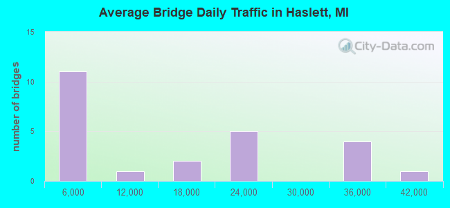
- 342,476Total average daily traffic
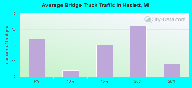
- 47,854Total average daily truck traffic
- National Bridge Inventory (NBI) Registered Bridges for Haslett
- No street view available for this location
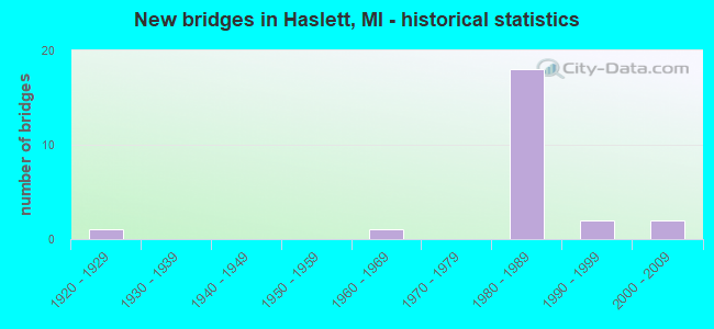
- New bridges - historical statistics
- 11920-1929
- 11960-1969
- 181980-1989
- 21990-1999
- 22000-2009
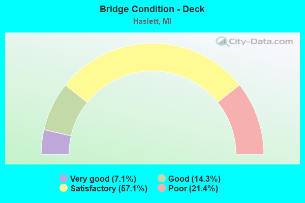
- Bridge Condition - Deck
- 7.1%Very good
- 14.3%Good
- 57.1%Satisfactory
- 21.4%Poor
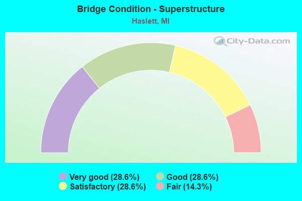
- Bridge Condition - Superstructure
- 28.6%Very good
- 28.6%Good
- 28.6%Satisfactory
- 14.3%Fair
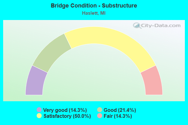
- Bridge Condition - Substructure
- 14.3%Very good
- 21.4%Good
- 50.0%Satisfactory
- 14.3%Fair
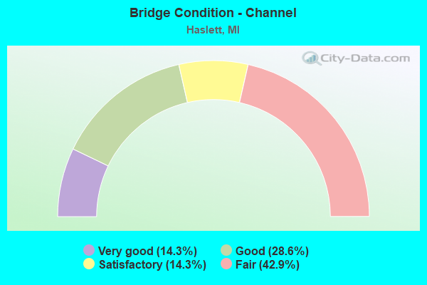
- Bridge Condition - Channel
- 14.3%Very good
- 28.6%Good
- 14.3%Satisfactory
- 42.9%Fair
Find on map >> Show street view
Structure Number: 1854, Location: 3.5 MI NE OF EAST LANSING (Lat: 42.782142, Lng: -84.408375), Route carried "on" structure: Ramp Interstate 69, Year Built: 1985, Status: Open, Structure Length: 9.08m (29.79ft), Average Daily Traffic: 8,945 (year 2007), Truck Traffic: 20%, Average Future Daily Traffic: 10,075 (year 2015), Design Load: HS 25 or greater, Features Intersected: I-69
Minimum Vertical Clearance: 30.48m (100.00ft), Kilometerpoint: 1.796, Lanes on structure: 2, Lanes under structure: 4, Owner: State Highway Agency, Approaching Roadway Width: 14.6m (47.9ft), Skew: 1 degrees, Material/Design: Steel continuous, Design/Construction: Stringer/Multi-beam, Number Of Spans In Main Unit: 4, Length of Maximum Span: 33.5m (109.9ft), Curb-To-Curb Width: 12.2m (40.0ft), Out-to-Out Width: 13.1m (43.0ft)
Condition: Deck: Satisfactory, Superstructure: Satisfactory, Substructure: Good, Operating Rating: 75.5 metric tons, Method Used To Determine Operating Rating: Load Factor (LF) rating reported by rating factor (RF) method using MS18 loading, Inventory Rating: 45.0 metric tons, Method Used To Determine Inventory Rating: Load Factor (LF) rating reported by rating factor (RF) method using MS18 loading, Structural Evaluation: Equal to present minimum criteria, Deck Geometry: Superior to present desirable criteria, Underclear: Equal to present minimum criteria, Approach Roadway Alignment: Equal to present desirable criteria, Designated Inspection Frequency: Every 24 months, Inspection Date: May 2020, Deck Structure Type: Concrete Cast-file-Place, Wearing Surface/Protective System: Wearing Surface: Epoxy Overlay, Deck Protection: Epoxy Coated Reinforcing
Find on map >> Show street view
Structure Number: 1855, Location: 4 MI NE OF EAST LANSING (Lat: 42.780956, Lng: -84.398400), Route carried "on" structure: County highway 1985, Year Built: 1985, Status: Open, Structure Length: 8.04m (26.38ft), Average Daily Traffic: 1,882 (year 1984), Truck Traffic: 3%, Average Future Daily Traffic: 4,750 (year 2015), Design Load: HS 25 or greater, Features Intersected: I-69, Facility Carried by Structure: UPTON RD
Minimum Vertical Clearance: 30.48m (100.00ft), Kilometerpoint: 0.641, Lanes on structure: 2, Lanes under structure: 4, Owner: State Highway Agency, Approaching Roadway Width: 14.6m (47.9ft), Material/Design: Steel continuous, Design/Construction: Stringer/Multi-beam, Number Of Spans In Main Unit: 2, Length of Maximum Span: 41.4m (135.8ft), Curb-To-Curb Width: 12.2m (40.0ft), Out-to-Out Width: 13.1m (43.0ft)
Condition: Deck: Satisfactory, Superstructure: Satisfactory, Substructure: Good, Operating Rating: 61.9 metric tons, Method Used To Determine Operating Rating: Load Factor (LF) rating reported by rating factor (RF) method using MS18 loading, Inventory Rating: 37.3 metric tons, Method Used To Determine Inventory Rating: Load Factor (LF) rating reported by rating factor (RF) method using MS18 loading, Structural Evaluation: Equal to present minimum criteria, Deck Geometry: Better than present minimum criteria, Underclear: Somewhat better than minimum adequacy, Approach Roadway Alignment: Equal to present desirable criteria, Designated Inspection Frequency: Every 24 months, Inspection Date: May 2020, Deck Structure Type: Concrete Cast-file-Place, Wearing Surface/Protective System: Wearing Surface: Latex Concrete, Deck Protection: Epoxy Coated Reinforcing
Find on map >> Show street view
Structure Number: 1856, Location: 0.5 MI W OF COUNTY LINE (Lat: 42.789933, Lng: -84.373722), Route carried "on" structure: Interstate 69, Year Built: 1989, Status: Open, Structure Length: 4.45m (14.60ft), Average Daily Traffic: 17,652 (year 2007), Truck Traffic: 13%, Average Future Daily Traffic: 26,031 (year 2018), Design Load: HS 25 or greater, Features Intersected: PEACOCK ROAD
Minimum Vertical Clearance: 30+ m (98+ ft), Kilometerpoint: 27.794, Lanes on structure: 2, Lanes under structure: 2, Base Highway Network: Yes (Inventory Route: 36, Subroute: 5), Owner: State Highway Agency, Approaching Roadway Width: 13.4m (44.0ft), Skew: 4 degrees, Material/Design: Prestressed concrete, Design/Construction: Stringer/Multi-beam, Number Of Spans In Main Unit: 3, Length of Maximum Span: 20.4m (66.9ft), Curb-To-Curb Width: 13.4m (44.0ft), Out-to-Out Width: 14.3m (46.9ft)
Condition: Deck: Poor, Superstructure: Satisfactory, Substructure: Satisfactory, Operating Rating: 57.7 metric tons, Method Used To Determine Operating Rating: Load and Resistance Factor Rating (LRFR) rating reported by rating factor(RF) method using HL-93 loadings, Inventory Rating: 39.9 metric tons, Method Used To Determine Inventory Rating: Load and Resistance Factor Rating (LRFR) rating reported by rating factor(RF) method using HL-93 loadings, Structural Evaluation: Equal to present minimum criteria, Deck Geometry: Superior to present desirable criteria, Underclear: Meets minimum limits, Approach Roadway Alignment: Equal to present desirable criteria, Designated Inspection Frequency: Every 12 months, Other Special Inspection Frequency: Every 24 months, Inspection Date: May 2021, Other Special Inspection Date: May 2021, Deck Structure Type: Concrete Cast-file-Place, Wearing Surface/Protective System: Wearing Surface: Epoxy Overlay, Deck Protection: Epoxy Coated Reinforcing
Find on map >> Show street view
Structure Number: 1857, Location: 0.5 MI W OF COUNTY LINE (Lat: 42.790408, Lng: -84.373694), Route carried "on" structure: Interstate 69, Year Built: 1989, Status: Open, Structure Length: 4.45m (14.60ft), Average Daily Traffic: 17,652 (year 2007), Truck Traffic: 13%, Average Future Daily Traffic: 26,031 (year 2018), Design Load: HS 25 or greater, Features Intersected: PEACOCK ROAD
Minimum Vertical Clearance: 30+ m (98+ ft), Kilometerpoint: 28.465, Lanes on structure: 2, Lanes under structure: 2, Base Highway Network: Yes (Inventory Route: 36, Subroute: 2), Owner: State Highway Agency, Approaching Roadway Width: 13.4m (44.0ft), Skew: 4 degrees, Material/Design: Prestressed concrete, Design/Construction: Stringer/Multi-beam, Number Of Spans In Main Unit: 3, Length of Maximum Span: 20.4m (66.9ft), Curb-To-Curb Width: 13.4m (44.0ft), Out-to-Out Width: 14.4m (47.2ft)
Condition: Deck: Poor, Superstructure: Satisfactory, Substructure: Satisfactory, Operating Rating: 58.6 metric tons, Method Used To Determine Operating Rating: Load and Resistance Factor Rating (LRFR) rating reported by rating factor(RF) method using HL-93 loadings, Inventory Rating: 40.5 metric tons, Method Used To Determine Inventory Rating: Load and Resistance Factor Rating (LRFR) rating reported by rating factor(RF) method using HL-93 loadings, Structural Evaluation: Equal to present minimum criteria, Deck Geometry: Superior to present desirable criteria, Underclear: Meets minimum limits, Approach Roadway Alignment: Equal to present desirable criteria, Designated Inspection Frequency: Every 24 months, Other Special Inspection Frequency: Every 12 months, Inspection Date: May 2021, Other Special Inspection Date: May 2021, Deck Structure Type: Concrete Cast-file-Place, Wearing Surface/Protective System: Wearing Surface: Epoxy Overlay, Deck Protection: Epoxy Coated Reinforcing
Find on map >> Show street view
Structure Number: 3881, Location: IN HASLETT (Lat: 42.744978, Lng: -84.408308), Route carried "on" structure: County highway 2003, Year Built: 1964, Year Reconstructed: 2016, Status: Open, Structure Length: 4.55m (14.93ft), Average Daily Traffic: 21,900 (year 2014), Truck Traffic: 3%, Average Future Daily Traffic: 32,500 (year 2034), Design Load: Greater than HL93, Features Intersected: GRAND TRUNK RR, Facility Carried by Structure: MARSH ROAD
Minimum Vertical Clearance: 30.48m (100.00ft), Kilometerpoint: 3.724, Lanes on structure: 4, Owner: County Highway Agency, Approaching Roadway Width: 14.0m (45.9ft), Skew: 3 degrees, Material/Design: Steel, Design/Construction: Stringer/Multi-beam, Number Of Spans In Main Unit: 3, Length of Maximum Span: 17.5m (57.4ft), Curb or Sidewalk Widths: Left: 0.0m, Right: 2.1m (6.9ft), Curb-To-Curb Width: 15.5m (50.9ft), Out-to-Out Width: 18.3m (60.0ft)
Condition: Deck: Very good, Superstructure: Very good, Substructure: Good, Operating Rating: 48.6 metric tons, Method Used To Determine Operating Rating: Load and Resistance Factor Rating (LRFR) rating reported by rating factor(RF) method using HL-93 loadings, Inventory Rating: 37.6 metric tons, Method Used To Determine Inventory Rating: Load and Resistance Factor Rating (LRFR) rating reported by rating factor(RF) method using HL-93 loadings, Structural Evaluation: Better than present minimum criteria, Deck Geometry: Meets minimum limits, Underclear: Equal to present desirable criteria, Approach Roadway Alignment: Equal to present desirable criteria, Length Of Structure Improvement: 4.54m (14.90ft), Designated Inspection Frequency: Every 24 months, Inspection Date: November 2020, Bridge Improvement Cost: $458,000, Roadway Improvement Cost: $55,000, Total Project Cost: $513,000, Deck Structure Type: Concrete Cast-file-Place, Wearing Surface/Protective System: Wearing Surface: Monolithic Concrete, Deck Protection: Epoxy Coated Reinforcing
Find on map >> Show street view
Structure Number: 9729, Location: 1.3 MI NE OF CLINTON COL (Lat: 42.801933, Lng: -84.337931), Route carried "on" structure: State highway 78, Year Built: 2009, Status: Open, Structure Length: 2.44m (8.01ft), Average Daily Traffic: 4,397 (year 2007), Truck Traffic: 1%, Average Future Daily Traffic: 6,400 (year 2029), Design Load: Greater than HL93, Features Intersected: VERMILLION CREEK
Minimum Vertical Clearance: 30+ m (98+ ft), Kilometerpoint: 2.437, Lanes on structure: 2, Base Highway Network: Yes (Inventory Route: 55, Subroute: 3), Owner: State Highway Agency, Approaching Roadway Width: 13.4m (44.0ft), Skew: 1 degrees, Material/Design: Prestressed concrete, Design/Construction: Box Beam or Girders - Single/Spread, Number Of Spans In Main Unit: 1, Length of Maximum Span: 23.5m (77.1ft), Curb-To-Curb Width: 13.4m (44.0ft), Out-to-Out Width: 14.4m (47.2ft)
Condition: Deck: Good, Superstructure: Very good, Substructure: Very good, Channel: Satisfactory, Operating Rating: 56.4 metric tons, Method Used To Determine Operating Rating: Load and Resistance Factor (LRFR), Inventory Rating: 38.3 metric tons, Method Used To Determine Inventory Rating: Load and Resistance Factor (LRFR), Structural Evaluation: Equal to present desirable criteria, Deck Geometry: Better than present minimum criteria, Waterway Adequacy: Equal to present desirable criteria, Approach Roadway Alignment: Equal to present desirable criteria, Designated Inspection Frequency: Every 24 months, Inspection Date: June 2021, Deck Structure Type: Concrete Cast-file-Place, Wearing Surface/Protective System: Wearing Surface: Monolithic Concrete, Deck Protection: Epoxy Coated Reinforcing
Find on map >> Show street view
Structure Number: 9755, Location: 1.5 MI E CLINTON CO LINE (Lat: 42.802297, Lng: -84.338664), Route carried "on" structure: Interstate 69, Year Built: 1989, Status: Open, Structure Length: 2.14m (7.02ft), Average Daily Traffic: 20,138 (year 2020), Truck Traffic: 15%, Average Future Daily Traffic: 22,263 (year 2040), Design Load: HS 25 or greater, Features Intersected: VERMILLION CREEK
Minimum Vertical Clearance: 30.48m (100.00ft), Kilometerpoint: 2.174, Lanes on structure: 2, Base Highway Network: Yes (Inventory Route: 55, Subroute: 8), Owner: State Highway Agency, Approaching Roadway Width: 12.8m (42.0ft), Skew: 5 degrees, Material/Design: Prestressed concrete, Design/Construction: Stringer/Multi-beam, Number Of Spans In Main Unit: 1, Length of Maximum Span: 21.3m (69.9ft), Curb-To-Curb Width: 13.4m (44.0ft), Out-to-Out Width: 14.4m (47.2ft)
Condition: Deck: Satisfactory, Superstructure: Good, Substructure: Satisfactory, Channel: Fair, Operating Rating: 77.8 metric tons, Method Used To Determine Operating Rating: Load Factor (LF) rating reported by rating factor (RF) method using MS18 loading, Inventory Rating: 44.7 metric tons, Method Used To Determine Inventory Rating: Load Factor (LF) rating reported by rating factor (RF) method using MS18 loading, Structural Evaluation: Equal to present minimum criteria, Deck Geometry: Superior to present desirable criteria, Waterway Adequacy: Equal to present desirable criteria, Approach Roadway Alignment: Equal to present desirable criteria, Designated Inspection Frequency: Every 24 months, Inspection Date: June 2021, Deck Structure Type: Concrete Cast-file-Place, Wearing Surface/Protective System: Wearing Surface: Epoxy Overlay, Deck Protection: Epoxy Coated Reinforcing
Find on map >> Show street view
Structure Number: 9756, Location: 1.5 MI E CLINTON CO LINE (Lat: 42.802475, Lng: -84.339353), Route carried "on" structure: Interstate 69, Year Built: 1989, Status: Open, Structure Length: 2.14m (7.02ft), Average Daily Traffic: 20,138 (year 2020), Truck Traffic: 15%, Average Future Daily Traffic: 22,263 (year 2040), Design Load: HS 25 or greater, Features Intersected: VERMILLION CREEK
Minimum Vertical Clearance: 30.48m (100.00ft), Kilometerpoint: 2.118, Lanes on structure: 2, Base Highway Network: Yes (Inventory Route: 55, Subroute: 9), Owner: State Highway Agency, Approaching Roadway Width: 7.3m (24.0ft), Skew: 5 degrees, Material/Design: Prestressed concrete, Design/Construction: Stringer/Multi-beam, Number Of Spans In Main Unit: 1, Length of Maximum Span: 21.3m (69.9ft), Curb-To-Curb Width: 13.4m (44.0ft), Out-to-Out Width: 14.4m (47.2ft)
Condition: Deck: Satisfactory, Superstructure: Good, Substructure: Satisfactory, Channel: Fair, Operating Rating: 54.8 metric tons, Method Used To Determine Operating Rating: Load and Resistance Factor Rating (LRFR) rating reported by rating factor(RF) method using HL-93 loadings, Inventory Rating: 43.4 metric tons, Method Used To Determine Inventory Rating: Load and Resistance Factor Rating (LRFR) rating reported by rating factor(RF) method using HL-93 loadings, Structural Evaluation: Equal to present minimum criteria, Deck Geometry: Superior to present desirable criteria, Waterway Adequacy: Equal to present desirable criteria, Approach Roadway Alignment: Equal to present desirable criteria, Designated Inspection Frequency: Every 24 months, Inspection Date: June 2021, Deck Structure Type: Concrete Cast-file-Place, Wearing Surface/Protective System: Wearing Surface: Epoxy Overlay, Deck Protection: Epoxy Coated Reinforcing
Find on map >> Show street view
Structure Number: 9758, Location: 0.6 M E OF CLINTON COL (Lat: 42.799917, Lng: -84.349725), Route carried "on" structure: County highway 7605, Year Built: 1989, Status: Open, Structure Length: 11.25m (36.91ft), Average Daily Traffic: 2,945 (year 1993), Truck Traffic: 2%, Average Future Daily Traffic: 1,500 (year 2013), Design Load: HS 25 or greater, Features Intersected: I-69, Facility Carried by Structure: WOODBURY RD
Minimum Vertical Clearance: 30.48m (100.00ft), Kilometerpoint: 3.372, Lanes on structure: 2, Lanes under structure: 4, Owner: State Highway Agency, Approaching Roadway Width: 12.8m (42.0ft), Skew: 5 degrees, Material/Design: Steel continuous, Design/Construction: Stringer/Multi-beam, Number Of Spans In Main Unit: 2, Number Of Approach Spans: 2, Length of Maximum Span: 44.5m (146.0ft), Curb-To-Curb Width: 13.4m (44.0ft), Out-to-Out Width: 14.4m (47.2ft)
Condition: Deck: Satisfactory, Superstructure: Fair, Substructure: Satisfactory, Operating Rating: 66.7 metric tons, Method Used To Determine Operating Rating: Load Factor (LF) rating reported by rating factor (RF) method using MS18 loading, Inventory Rating: 39.9 metric tons, Method Used To Determine Inventory Rating: Load Factor (LF) rating reported by rating factor (RF) method using MS18 loading, Structural Evaluation: Somewhat better than minimum adequacy, Deck Geometry: Better than present minimum criteria, Underclear: Somewhat better than minimum adequacy, Approach Roadway Alignment: Equal to present desirable criteria, Designated Inspection Frequency: Every 24 months, Inspection Date: June 2021, Deck Structure Type: Concrete Cast-file-Place, Wearing Surface/Protective System: Wearing Surface: Epoxy Overlay, Deck Protection: Epoxy Coated Reinforcing
Find on map >> Show street view
Structure Number: 9764, Location: 1.5 MI W OF SHAFTSBURG (Lat: 42.806239, Lng: -84.322819), Route carried "on" structure: Interstate 69, Year Built: 1989, Status: Open, Structure Length: 3.07m (10.07ft), Average Daily Traffic: 20,138 (year 2020), Truck Traffic: 15%, Average Future Daily Traffic: 22,263 (year 2040), Design Load: HS 25 or greater, Features Intersected: COLBY LAKE RD
Minimum Vertical Clearance: 30.48m (100.00ft), Kilometerpoint: 3.542, Lanes on structure: 2, Lanes under structure: 2, Base Highway Network: Yes (Inventory Route: 55, Subroute: 8), Owner: State Highway Agency, Approaching Roadway Width: 12.8m (42.0ft), Skew: 1 degrees, Material/Design: Prestressed concrete, Design/Construction: Stringer/Multi-beam, Number Of Spans In Main Unit: 1, Length of Maximum Span: 29.9m (98.1ft), Curb-To-Curb Width: 13.4m (44.0ft), Out-to-Out Width: 14.4m (47.2ft)
Condition: Deck: Satisfactory, Superstructure: Good, Substructure: Fair, Operating Rating: 76.8 metric tons, Method Used To Determine Operating Rating: Load Factor (LF) rating reported by rating factor (RF) method using MS18 loading, Inventory Rating: 42.1 metric tons, Method Used To Determine Inventory Rating: Load Factor (LF) rating reported by rating factor (RF) method using MS18 loading, Structural Evaluation: Somewhat better than minimum adequacy, Deck Geometry: Superior to present desirable criteria, Underclear: Equal to present minimum criteria, Approach Roadway Alignment: Equal to present desirable criteria, Designated Inspection Frequency: Every 24 months, Inspection Date: June 2021, Deck Structure Type: Concrete Cast-file-Place, Wearing Surface/Protective System: Wearing Surface: Epoxy Overlay, Deck Protection: Epoxy Coated Reinforcing
Find on map >> Show street view
Structure Number: 9765, Location: 1.5 MI W OF SHAFTSBURG (Lat: 42.806592, Lng: -84.322839), Route carried "on" structure: Interstate 69, Year Built: 1989, Status: Open, Structure Length: 2.98m (9.78ft), Average Daily Traffic: 20,138 (year 2020), Truck Traffic: 15%, Average Future Daily Traffic: 22,263 (year 2040), Design Load: HS 25 or greater, Features Intersected: COLBY LAKE RD
Minimum Vertical Clearance: 30.48m (100.00ft), Kilometerpoint: 3.544, Lanes on structure: 2, Lanes under structure: 2, Base Highway Network: Yes (Inventory Route: 55, Subroute: 9), Owner: State Highway Agency, Approaching Roadway Width: 12.8m (42.0ft), Skew: 1 degrees, Material/Design: Prestressed concrete, Design/Construction: Stringer/Multi-beam, Number Of Spans In Main Unit: 1, Length of Maximum Span: 29.8m (97.8ft), Curb-To-Curb Width: 13.4m (44.0ft), Out-to-Out Width: 14.4m (47.2ft)
Condition: Deck: Satisfactory, Superstructure: Good, Substructure: Fair, Operating Rating: 86.5 metric tons, Method Used To Determine Operating Rating: Load Factor (LF) rating reported by rating factor (RF) method using MS18 loading, Inventory Rating: 41.8 metric tons, Method Used To Determine Inventory Rating: Load Factor (LF) rating reported by rating factor (RF) method using MS18 loading, Structural Evaluation: Somewhat better than minimum adequacy, Deck Geometry: Superior to present desirable criteria, Underclear: Equal to present minimum criteria, Approach Roadway Alignment: Equal to present desirable criteria, Designated Inspection Frequency: Every 24 months, Inspection Date: June 2021, Deck Structure Type: Concrete Cast-file-Place, Wearing Surface/Protective System: Wearing Surface: Epoxy Overlay, Deck Protection: Epoxy Coated Reinforcing
Find on map >> Show street view
Structure Number: 9779, Location: 5 MILES S OF LAINGSBURG (Lat: 42.819142, Lng: -84.356650), Route carried "on" structure: County highway , Year Built: 1925, Status: Open, Structure Length: 1.25m (4.10ft), Average Daily Traffic: 910 (year 2010), Truck Traffic: 10%, Average Future Daily Traffic: 931 (year 2031), Design Load: H 20, Features Intersected: S BR LOOKINGGLASS RIVER, Facility Carried by Structure: BATH ROAD
Minimum Vertical Clearance: 30.48m (100.00ft), Kilometerpoint: 1.434, Lanes on structure: 2, Owner: County Highway Agency, Approaching Roadway Width: 9.1m (29.9ft), Material/Design: Concrete, Design/Construction: Girder and Floorbeam System, Number Of Spans In Main Unit: 1, Length of Maximum Span: 11.2m (36.7ft), Curb or Sidewalk Widths: Left: 0.2m (0.7ft), Right: 0.2m (0.7ft), Curb-To-Curb Width: 7.0m (23.0ft), Out-to-Out Width: 8.3m (27.2ft)
Condition: Deck: Poor, Superstructure: Fair, Substructure: Satisfactory, Channel: Fair, Operating Rating: 46.3 metric tons, Method Used To Determine Operating Rating: Load Factor (LF) rating reported by rating factor (RF) method using MS18 loading, Inventory Rating: 27.5 metric tons, Method Used To Determine Inventory Rating: Load Factor (LF) rating reported by rating factor (RF) method using MS18 loading, Structural Evaluation: Somewhat better than minimum adequacy, Deck Geometry: Meets minimum limits, Waterway Adequacy: Equal to present minimum criteria, Approach Roadway Alignment: Better than present minimum criteria, Length Of Structure Improvement: 1.83m (6.00ft), Designated Inspection Frequency: Every 12 months, Inspection Date: March 2022, Bridge Improvement Cost: $240,000, Roadway Improvement Cost: $25,000, Total Project Cost: $280,000, Deck Structure Type: Concrete Cast-file-Place, Wearing Surface/Protective System: Wearing Surface: Bituminous
Find on map >> Show street view
Structure Number: 9804, Location: 5.5 MILES S OF LAINGSBURG (Lat: 42.803189, Lng: -84.347864), Route carried "on" structure: County highway 7607, Year Built: 1990, Status: Open, Structure Length: 1.55m (5.09ft), Average Daily Traffic: 4,809 (year 2005), Truck Traffic: 15%, Average Future Daily Traffic: 7,146 (year 2025), Design Load: H 20, Features Intersected: S BR LOOKINGGLASS RIVER, Facility Carried by Structure: WOODBURY ROAD
Minimum Vertical Clearance: 30.48m (100.00ft), Kilometerpoint: 0.678, Lanes on structure: 2, Owner: County Highway Agency, Approaching Roadway Width: 11.9m (39.0ft), Skew: 2 degrees, Material/Design: Prestressed concrete, Design/Construction: Stringer/Multi-beam, Number Of Spans In Main Unit: 1, Length of Maximum Span: 14.9m (48.9ft), Curb or Sidewalk Widths: Left: 0.4m (1.3ft), Right: 0.4m (1.3ft), Curb-To-Curb Width: 13.1m (43.0ft), Out-to-Out Width: 14.3m (46.9ft)
Condition: Deck: Satisfactory, Superstructure: Very good, Substructure: Satisfactory, Channel: Very good, Operating Rating: 67.7 metric tons, Method Used To Determine Operating Rating: Load Factor (LF) rating reported by rating factor (RF) method using MS18 loading, Inventory Rating: 40.5 metric tons, Method Used To Determine Inventory Rating: Load Factor (LF) rating reported by rating factor (RF) method using MS18 loading, Structural Evaluation: Equal to present minimum criteria, Deck Geometry: Equal to present minimum criteria, Waterway Adequacy: Superior to present desirable criteria, Approach Roadway Alignment: Equal to present desirable criteria, Designated Inspection Frequency: Every 24 months, Inspection Date: March 2022, Deck Structure Type: Concrete Cast-file-Place, Wearing Surface/Protective System: Wearing Surface: Monolithic Concrete, Deck Protection: Epoxy Coated Reinforcing
Find on map >> Show street view
Structure Number: 9807, Location: 1 MI SOUTH OF SHAFTSBURG (Lat: 42.788853, Lng: -84.292625), Route carried "on" structure: County highway 7613, Year Built: 1994, Status: Open, Structure Length: 0.85m (2.79ft), Average Daily Traffic: 645 (year 2011), Truck Traffic: 20%, Average Future Daily Traffic: 959 (year 2031), Design Load: HS 20, Features Intersected: S BR LOOKINGGLASS RIVER, Facility Carried by Structure: SHAFTSBURG ROAD
Minimum Vertical Clearance: 30.48m (100.00ft), Kilometerpoint: 1.426, Lanes on structure: 2, Owner: County Highway Agency, Approaching Roadway Width: 11.9m (39.0ft), Skew: 3 degrees, Material/Design: Concrete, Design/Construction: Culvert, Number Of Spans In Main Unit: 1, Length of Maximum Span: 8.5m (27.9ft), Curb-To-Curb Width: 11.9m (39.0ft), Out-to-Out Width: 12.5m (41.0ft)
Condition: Channel: Good, Culverts: Very good, Operating Rating: 39.9 metric tons, Method Used To Determine Operating Rating: Load and Resistance Factor Rating (LRFR) rating reported by rating factor(RF) method using HL-93 loadings, Inventory Rating: 30.8 metric tons, Method Used To Determine Inventory Rating: Load and Resistance Factor Rating (LRFR) rating reported by rating factor(RF) method using HL-93 loadings, Structural Evaluation: Better than present minimum criteria, Deck Geometry: Better than present minimum criteria, Waterway Adequacy: Equal to present desirable criteria, Approach Roadway Alignment: Equal to present desirable criteria, Designated Inspection Frequency: Every 24 months, Inspection Date: April 2020, Deck Structure Type: Concrete Cast-file-Place, Wearing Surface/Protective System: Wearing Surface: Bituminous
Find on map >> Show street view
Structure Number: 9883, Location: 1 MI SW OF SHAFTSBURG (Lat: 42.797400, Lng: -84.312672), Route carried "on" structure: County highway , Year Built: 2001, Status: Open, Structure Length: 1.83m (6.00ft), Average Daily Traffic: 510 (year 2000), Truck Traffic: 5%, Average Future Daily Traffic: 921 (year 2020), Design Load: HS 20, Features Intersected: S BR LOOKINGGLASS RIVER, Facility Carried by Structure: WARNER RD
Minimum Vertical Clearance: 30.48m (100.00ft), Kilometerpoint: 3.587, Lanes on structure: 2, Owner: County Highway Agency, Approaching Roadway Width: 10.1m (33.1ft), Skew: 5 degrees, Material/Design: Prestressed concrete, Design/Construction: Box Beam or Girders - Multiple, Number Of Spans In Main Unit: 1, Length of Maximum Span: 18.3m (60.0ft), Curb-To-Curb Width: 10.1m (33.1ft), Out-to-Out Width: 10.5m (34.4ft)
Condition: Deck: Good, Superstructure: Very good, Substructure: Very good, Channel: Good, Operating Rating: 73.2 metric tons, Method Used To Determine Operating Rating: Load Factor (LF) rating reported by rating factor (RF) method using MS18 loading, Inventory Rating: 43.7 metric tons, Method Used To Determine Inventory Rating: Load Factor (LF) rating reported by rating factor (RF) method using MS18 loading, Structural Evaluation: Equal to present desirable criteria, Deck Geometry: Equal to present minimum criteria, Waterway Adequacy: Better than present minimum criteria, Approach Roadway Alignment: Equal to present desirable criteria, Designated Inspection Frequency: Every 24 months, Inspection Date: April 2020, Deck Structure Type: Concrete Cast-file-Place, Wearing Surface/Protective System: Wearing Surface: Integral Concrete, Deck Protection: Epoxy Coated Reinforcing
Find on map >> Show street view
Structure Number: 1852, Location: 4.0 MI N OF EAST LANSING (Lat: 42.785689, Lng: -84.418322), Route carried "under" structure: Interstate 69, Year Built: 1985, Structure Length: 0. m, Average Daily Traffic: 32,604 (year 2007), Truck Traffic: 19%, Features Intersected: I-69, Facility Carried by Structure: CENTER RD
Minimum Vertical Clearance: 5.21m (17.09ft), Kilometerpoint: 23.713, Lanes on structure: 2, Lanes under structure: 4, Material/Design: Steel continuous, Design/Construction: Stringer/Multi-beam, Length of Maximum Span: 42.3m (138.8ft)
Find on map >> Show street view
Structure Number: 1853, Location: 3 MI NE OF EAST LANSING (Lat: 42.782233, Lng: -84.408800), Route carried "under" structure: Interstate 69, Year Built: 1985, Structure Length: 0. m, Average Daily Traffic: 32,604 (year 2007), Truck Traffic: 19%, Features Intersected: I-69
Minimum Vertical Clearance: 5.74m (18.83ft), Kilometerpoint: 24.585, Lanes on structure: 1, Lanes under structure: 4, Material/Design: Steel continuous, Design/Construction: Stringer/Multi-beam, Length of Maximum Span: 33.8m (110.9ft)
Find on map >> Show street view
Structure Number: 1854, Location: 3.5 MI NE OF EAST LANSING (Lat: 42.782142, Lng: -84.408375), Route carried "under" structure: Interstate 69, Year Built: 1985, Structure Length: 0. m, Average Daily Traffic: 35,304 (year 2007), Truck Traffic: 13%, Features Intersected: I-69
Minimum Vertical Clearance: 5.82m (19.09ft), Kilometerpoint: 24.621, Lanes on structure: 2, Lanes under structure: 4, Material/Design: Steel continuous, Design/Construction: Stringer/Multi-beam, Length of Maximum Span: 33.5m (109.9ft)
Find on map >> Show street view
Structure Number: 1855, Location: 4 MI NE OF EAST LANSING (Lat: 42.780956, Lng: -84.398400), Route carried "under" structure: Interstate 69, Year Built: 1985, Structure Length: 0. m, Average Daily Traffic: 35,304 (year 2007), Truck Traffic: 13%, Features Intersected: I-69, Facility Carried by Structure: UPTON RD
Minimum Vertical Clearance: 4.98m (16.34ft), Kilometerpoint: 25.467, Lanes on structure: 2, Lanes under structure: 4, Material/Design: Steel continuous, Design/Construction: Stringer/Multi-beam, Length of Maximum Span: 41.4m (135.8ft)
Find on map >> Show street view
Structure Number: 1856, Location: 0.5 MI W OF COUNTY LINE (Lat: 42.789933, Lng: -84.373722), Route carried "under" structure: County highway , Year Built: 1989, Structure Length: 0. m, Average Daily Traffic: 1,500 (year 1982), Features Intersected: PEACOCK ROAD, Facility Carried by Structure: I-69 EB
Minimum Vertical Clearance: 4.52m (14.83ft), Kilometerpoint: 0.901, Lanes on structure: 2, Lanes under structure: 2, Material/Design: Prestressed concrete, Design/Construction: Stringer/Multi-beam, Length of Maximum Span: 20.4m (66.9ft)
Find on map >> Show street view
Structure Number: 1857, Location: 0.5 MI W OF COUNTY LINE (Lat: 42.790408, Lng: -84.373694), Route carried "under" structure: County highway , Year Built: 1989, Structure Length: 0. m, Average Daily Traffic: 1,500 (year 1982), Features Intersected: PEACOCK ROAD, Facility Carried by Structure: I-69 WB
Minimum Vertical Clearance: 4.72m (15.49ft), Kilometerpoint: 0.950, Lanes on structure: 2, Lanes under structure: 2, Material/Design: Prestressed concrete, Design/Construction: Stringer/Multi-beam, Length of Maximum Span: 20.4m (66.9ft)
Find on map >> Show street view
Structure Number: 9758, Location: 0.6 M E OF CLINTON COL (Lat: 42.799917, Lng: -84.349725), Route carried "under" structure: Interstate 69, Year Built: 1989, Structure Length: 0. m, Average Daily Traffic: 40,275 (year 2020), Truck Traffic: 15%, Features Intersected: I-69, Facility Carried by Structure: WOODBURY RD
Minimum Vertical Clearance: 5.18m (16.99ft), Kilometerpoint: 1.201, Lanes on structure: 2, Lanes under structure: 4, Material/Design: Steel continuous, Design/Construction: Stringer/Multi-beam, Length of Maximum Span: 44.5m (146.0ft)
Find on map >> Show street view
Structure Number: 9764, Location: 1.5 MI W OF SHAFTSBURG (Lat: 42.806239, Lng: -84.322819), Route carried "under" structure: County highway , Year Built: 1989, Structure Length: 0. m, Average Daily Traffic: 293 (year 1991), Truck Traffic: 2%, Features Intersected: COLBY LAKE RD, Facility Carried by Structure: I-69 EB
Minimum Vertical Clearance: 4.80m (15.75ft), Kilometerpoint: 0.151, Lanes on structure: 2, Lanes under structure: 2, Material/Design: Prestressed concrete, Design/Construction: Stringer/Multi-beam, Length of Maximum Span: 29.9m (98.1ft)
Find on map >> Show street view
Structure Number: 9765, Location: 1.5 MI W OF SHAFTSBURG (Lat: 42.806592, Lng: -84.322839), Route carried "under" structure: County highway , Year Built: 1989, Structure Length: 0. m, Average Daily Traffic: 293 (year 1991), Truck Traffic: 2%, Features Intersected: COLBY LAKE RD, Facility Carried by Structure: I-69 WB
Minimum Vertical Clearance: 4.52m (14.83ft), Kilometerpoint: 0.190, Lanes on structure: 2, Lanes under structure: 2, Material/Design: Prestressed concrete, Design/Construction: Stringer/Multi-beam, Length of Maximum Span: 29.8m (97.8ft)