Bridge Statistics for Hastings, New York (NY)
Condition, Traffic, Stress, Structural Evaluation, Project Costs
- National Bridge Inventory (NBI) Statistics
- 28Number of bridges
- 331ft / 101mTotal length
- $47,848,000Total costs
- 225,126Total average daily traffic
- 16,747Total average daily truck traffic
- National Bridge Inventory (NBI) Registered Bridges for Hastings
- No street view available for this location
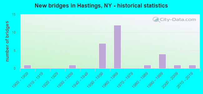
- New bridges - historical statistics
- 11900-1909
- 11930-1939
- 71950-1959
- 121960-1969
- 11980-1989
- 41990-1999
- 12000-2009
- 12010-2019
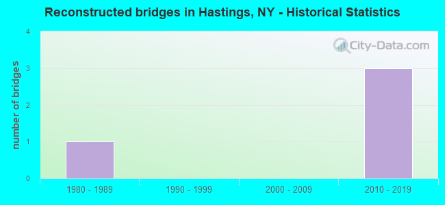
- Reconstructed bridges - Historical Statistics
- 11980-1989
- 01990-1999
- 02000-2009
- 32010-2019
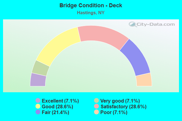
- Bridge Condition - Deck
- 7.1%Excellent
- 7.1%Very good
- 28.6%Good
- 28.6%Satisfactory
- 21.4%Fair
- 7.1%Poor
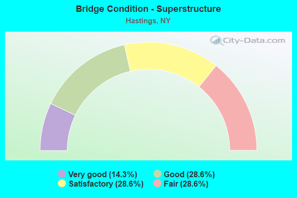
- Bridge Condition - Superstructure
- 14.3%Very good
- 28.6%Good
- 28.6%Satisfactory
- 28.6%Fair
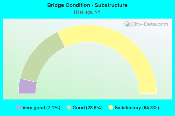
- Bridge Condition - Substructure
- 7.1%Very good
- 28.6%Good
- 64.3%Satisfactory
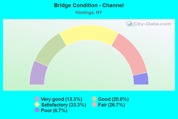
- Bridge Condition - Channel
- 13.3%Very good
- 20.0%Good
- 33.3%Satisfactory
- 26.7%Fair
- 6.7%Poor
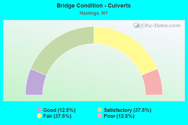
- Bridge Condition - Culverts
- 12.5%Good
- 37.5%Satisfactory
- 37.5%Fair
- 12.5%Poor
Find on map >> Show street view
Structure Number: 100855, Location: .8 MI S JCT US 11 & SH 49 (Lat: 43.274625, Lng: -76.144514), Route carried "on" structure: US 11, Year Built: 1994, Status: Open, Structure Length: 10.33m (33.89ft), Average Daily Traffic: 5,430 (year 2018), Truck Traffic: 9%, Average Future Daily Traffic: 6,718 (year 2040), Design Load: HS 25 or greater, Features Intersected: CSX TRANSPRTATION
Minimum Vertical Clearance: 30+ m (98+ ft), Kilometerpoint: 3.781, Lanes on structure: 2, Base Highway Network: Yes, Owner: State Highway Agency, Approaching Roadway Width: 12.2m (40.0ft), Skew: 3 degrees, Material/Design: Steel continuous, Design/Construction: Stringer/Multi-beam, Number Of Spans In Main Unit: 3, Length of Maximum Span: 39.9m (130.9ft), Curb-To-Curb Width: 12.2m (40.0ft), Out-to-Out Width: 13.2m (43.3ft)
Condition: Deck: Good, Superstructure: Good, Substructure: Satisfactory, Operating Rating: 78.9 metric tons, Method Used To Determine Operating Rating: Load Factor (LF), Inventory Rating: 44.5 metric tons, Method Used To Determine Inventory Rating: Load Factor (LF), Structural Evaluation: Equal to present minimum criteria, Deck Geometry: Somewhat better than minimum adequacy, Underclear: Somewhat better than minimum adequacy, Approach Roadway Alignment: Equal to present desirable criteria, Length Of Structure Improvement: 10.33m (33.89ft), Designated Inspection Frequency: Every 24 months, Inspection Date: June 2020, Bridge Improvement Cost: $2,796,000, Roadway Improvement Cost: $1,637,000, Total Project Cost: $4,433,000 ( Estimate for 2021), Deck Structure Type: Concrete Cast-file-Place, Wearing Surface/Protective System: Wearing Surface: Integral Concrete, Deck Protection: Epoxy Coated Reinforcing
Find on map >> Show street view
Structure Number: 102616, Location: 3.2 MI W JCT RTS 49 + 11 (Lat: 43.299111, Lng: -76.207436), Route carried "on" structure: State highway 49, Year Built: 1933, Year Reconstructed: 1991, Status: Open, Structure Length: 1.25m (4.10ft), Average Daily Traffic: 3,322 (year 2020), Truck Traffic: 7%, Average Future Daily Traffic: 3,342 (year 2040), Design Load: HS 20, Features Intersected: CAUGHDENOY CREEK
Minimum Vertical Clearance: 30+ m (98+ ft), Kilometerpoint: 11.022, Lanes on structure: 2, Base Highway Network: Yes, Owner: State Highway Agency, Approaching Roadway Width: 8.5m (27.9ft), Material/Design: Steel, Design/Construction: Stringer/Multi-beam, Number Of Spans In Main Unit: 1, Length of Maximum Span: 11.8m (38.7ft), Curb-To-Curb Width: 8.4m (27.6ft), Out-to-Out Width: 8.6m (28.2ft)
Condition: Deck: Fair, Superstructure: Good, Substructure: Satisfactory, Channel: Fair, Inventory Rating: 89.8 metric tons, Method Used To Determine Inventory Rating: Allowable Stress (AS), Structural Evaluation: Equal to present minimum criteria, Deck Geometry: High priority of corrective action, Waterway Adequacy: Meets minimum limits, Approach Roadway Alignment: Equal to present desirable criteria, Length Of Structure Improvement: 1.24m (4.07ft), Designated Inspection Frequency: Every 24 months, Inspection Date: April 2020, Bridge Improvement Cost: $233,000, Roadway Improvement Cost: $136,000, Total Project Cost: $370,000 ( Estimate for 2021), Deck Structure Type: Wood or Timber, Wearing Surface/Protective System: Wearing Surface: Bituminous
Find on map >> Show street view
Structure Number: 102618, Location: JCT OF RTS 49 + I-81 (Lat: 43.286278, Lng: -76.125369), Route carried "on" structure: State highway 49, Year Built: 1960, Status: Open, Structure Length: 6.89m (22.60ft), Average Daily Traffic: 10,087 (year 2020), Truck Traffic: 7%, Average Future Daily Traffic: 12,253 (year 2040), Design Load: HS 20, Features Intersected: 81I 81I34041036, RTE I81
Minimum Vertical Clearance: 30+ m (98+ ft), Kilometerpoint: 18.150, Lanes on structure: 4, Lanes under structure: 4, Base Highway Network: Yes, Owner: State Highway Agency, Approaching Roadway Width: 16.5m (54.1ft), Skew: 21 degrees, Material/Design: Steel, Design/Construction: Stringer/Multi-beam, Number Of Spans In Main Unit: 4, Length of Maximum Span: 21.9m (71.9ft), Curb or Sidewalk Widths: Left: 0.5m (1.6ft), Right: 0.5m (1.6ft), Curb-To-Curb Width: 16.5m (54.1ft), Out-to-Out Width: 19.3m (63.3ft)
Condition: Deck: Fair, Superstructure: Good, Substructure: Good, Operating Rating: 41.7 metric tons, Method Used To Determine Operating Rating: Load Factor (LF), Inventory Rating: 24.5 metric tons, Method Used To Determine Inventory Rating: Load Factor (LF), Structural Evaluation: Equal to present minimum criteria, Deck Geometry: Meets minimum limits, Underclear: High priority of corrective action, Approach Roadway Alignment: Equal to present desirable criteria, Length Of Structure Improvement: 6.88m (22.57ft), Designated Inspection Frequency: Every 24 months, Inspection Date: May 2020, Bridge Improvement Cost: $2,726,000, Roadway Improvement Cost: $1,596,000, Total Project Cost: $4,322,000 ( Estimate for 2021), Deck Structure Type: Concrete Cast-file-Place, Wearing Surface/Protective System: Wearing Surface: Monolithic Concrete
Find on map >> Show street view
Structure Number: 1031771, Location: W MONROE @ ONEIDA LAKE (Lat: 43.241442, Lng: -76.131194), Route carried "on" structure: Interstate 81, Year Built: 1959, Status: Open, Structure Length: 4.08m (13.39ft), Average Daily Traffic: 18,270 (year 2007), Truck Traffic: 13%, Design Load: HS 20, Features Intersected: CR 37 - SWAMP RD
Minimum Vertical Clearance: 30+ m (98+ ft), Kilometerpoint: 0.708, Lanes on structure: 3, Lanes under structure: 2, Base Highway Network: Yes, Owner: State Highway Agency, Approaching Roadway Width: 14.9m (48.9ft), Material/Design: Steel, Design/Construction: Stringer/Multi-beam, Number Of Spans In Main Unit: 3, Length of Maximum Span: 13.7m (44.9ft), Curb-To-Curb Width: 14.9m (48.9ft), Out-to-Out Width: 16.1m (52.8ft)
Condition: Deck: Good, Superstructure: Good, Substructure: Satisfactory, Operating Rating: 58.1 metric tons, Method Used To Determine Operating Rating: Load Factor (LF), Inventory Rating: 34.5 metric tons, Method Used To Determine Inventory Rating: Load Factor (LF), Structural Evaluation: Equal to present minimum criteria, Deck Geometry: Meets minimum limits, Underclear: Somewhat better than minimum adequacy, Approach Roadway Alignment: Equal to present desirable criteria, Length Of Structure Improvement: 4.08m (13.39ft), Designated Inspection Frequency: Every 24 months, Inspection Date: May 2020, Bridge Improvement Cost: $1,370,000, Roadway Improvement Cost: $802,000, Total Project Cost: $2,172,000 ( Estimate for 2021), Deck Structure Type: Concrete Cast-file-Place, Wearing Surface/Protective System: Wearing Surface: Monolithic Concrete
Find on map >> Show street view
Structure Number: 1031772, Location: W MONROE @ ONEIDA LAKE (Lat: 43.241456, Lng: -76.130972), Route carried "on" structure: Interstate 81, Year Built: 1959, Status: Open, Structure Length: 4.08m (13.39ft), Average Daily Traffic: 12,773 (year 2020), Truck Traffic: 13%, Average Future Daily Traffic: 18,425 (year 2040), Design Load: HS 20, Features Intersected: CR 37 - SWAMP RD
Minimum Vertical Clearance: 30+ m (98+ ft), Kilometerpoint: 0.724, Lanes on structure: 3, Lanes under structure: 2, Base Highway Network: Yes, Owner: State Highway Agency, Approaching Roadway Width: 14.9m (48.9ft), Material/Design: Steel, Design/Construction: Stringer/Multi-beam, Number Of Spans In Main Unit: 3, Length of Maximum Span: 13.7m (44.9ft), Curb-To-Curb Width: 14.9m (48.9ft), Out-to-Out Width: 16.1m (52.8ft)
Condition: Deck: Satisfactory, Superstructure: Fair, Substructure: Satisfactory, Operating Rating: 58.1 metric tons, Method Used To Determine Operating Rating: Load Factor (LF), Inventory Rating: 34.5 metric tons, Method Used To Determine Inventory Rating: Load Factor (LF), Structural Evaluation: Somewhat better than minimum adequacy, Deck Geometry: Meets minimum limits, Underclear: Somewhat better than minimum adequacy, Approach Roadway Alignment: Equal to present desirable criteria, Length Of Structure Improvement: 4.08m (13.39ft), Designated Inspection Frequency: Every 24 months, Inspection Date: April 2021, Bridge Improvement Cost: $1,370,000, Roadway Improvement Cost: $802,000, Total Project Cost: $2,172,000 ( Estimate for 2021), Deck Structure Type: Concrete Cast-file-Place, Wearing Surface/Protective System: Wearing Surface: Monolithic Concrete
Find on map >> Show street view
Structure Number: 103178, Location: 1.1 MI N JCT I81 & SH 49 (Lat: 43.304575, Lng: -76.126719), Route carried "on" structure: County highway , Year Built: 1960, Status: Open, Structure Length: 8.84m (29.00ft), Average Daily Traffic: 928 (year 2020), Truck Traffic: 8%, Average Future Daily Traffic: 954 (year 2040), Design Load: HS 20, Features Intersected: 81I 81I34041046 NB, RTE, Facility Carried by Structure: COUNTY ROAD 12
Minimum Vertical Clearance: 30+ m (98+ ft), Kilometerpoint: 19.228, Lanes on structure: 2, Lanes under structure: 8, Owner: State Highway Agency, Approaching Roadway Width: 9.1m (29.9ft), Skew: 4 degrees, Material/Design: Steel, Design/Construction: Stringer/Multi-beam, Number Of Spans In Main Unit: 5, Length of Maximum Span: 18.5m (60.7ft), Curb-To-Curb Width: 9.1m (29.9ft), Out-to-Out Width: 10.7m (35.1ft)
Condition: Deck: Fair, Superstructure: Satisfactory, Substructure: Satisfactory, Operating Rating: 51.7 metric tons, Method Used To Determine Operating Rating: Load Factor (LF), Inventory Rating: 30.8 metric tons, Method Used To Determine Inventory Rating: Load Factor (LF), Structural Evaluation: Equal to present minimum criteria, Deck Geometry: Equal to present minimum criteria, Underclear: High priority of corrective action, Approach Roadway Alignment: Equal to present desirable criteria, Length Of Structure Improvement: 8.83m (28.97ft), Designated Inspection Frequency: Every 24 months, Inspection Date: September 2021, Bridge Improvement Cost: $1,885,000, Roadway Improvement Cost: $1,104,000, Total Project Cost: $2,989,000 ( Estimate for 2021), Deck Structure Type: Concrete Cast-file-Place, Wearing Surface/Protective System: Wearing Surface: Bituminous, Membrane: Other
Find on map >> Show street view
Structure Number: 103179, Location: 2.6 MI N JCT RTS 81I + 49 (Lat: 43.327744, Lng: -76.124850), Route carried "on" structure: County highway , Year Built: 1960, Status: Open, Structure Length: 7.80m (25.59ft), Average Daily Traffic: 870 (year 2020), Truck Traffic: 8%, Average Future Daily Traffic: 894 (year 2040), Design Load: HS 20, Features Intersected: SB - 81I 81I34041063, RT, Facility Carried by Structure: COUNTY ROAD 32
Minimum Vertical Clearance: 30+ m (98+ ft), Kilometerpoint: 2.639, Lanes on structure: 2, Lanes under structure: 4, Owner: State Highway Agency, Approaching Roadway Width: 6.1m (20.0ft), Skew: 2 degrees, Material/Design: Steel, Design/Construction: Stringer/Multi-beam, Number Of Spans In Main Unit: 5, Length of Maximum Span: 16.4m (53.8ft), Curb or Sidewalk Widths: Left: 0.5m (1.6ft), Right: 0.5m (1.6ft), Curb-To-Curb Width: 9.1m (29.9ft), Out-to-Out Width: 10.7m (35.1ft)
Condition: Deck: Satisfactory, Superstructure: Satisfactory, Substructure: Satisfactory, Operating Rating: 28.2 metric tons, Method Used To Determine Operating Rating: Load and Resistance Factor Rating (LRFR) rating reported by rating factor(RF) method using HL-93 loadings, Inventory Rating: 21.7 metric tons, Method Used To Determine Inventory Rating: Load and Resistance Factor Rating (LRFR) rating reported by rating factor(RF) method using HL-93 loadings, Structural Evaluation: Somewhat better than minimum adequacy, Deck Geometry: Equal to present minimum criteria, Underclear: High priority of corrective action, Approach Roadway Alignment: Equal to present desirable criteria, Length Of Structure Improvement: 7.80m (25.59ft), Designated Inspection Frequency: Every 24 months, Inspection Date: April 2020, Bridge Improvement Cost: $1,649,000, Roadway Improvement Cost: $966,000, Total Project Cost: $2,615,000 ( Estimate for 2021), Deck Structure Type: Concrete Cast-file-Place, Wearing Surface/Protective System: Wearing Surface: Bituminous, Membrane: Other
Find on map >> Show street view
Structure Number: 1031801, Location: 2.9 MI N JCT RTS I81SB+49 (Lat: 43.330075, Lng: -76.123778), Route carried "on" structure: Interstate 81, Year Built: 1960, Status: Open, Structure Length: 0.82m (2.69ft), Average Daily Traffic: 11,875 (year 2013), Truck Traffic: 16%, Design Load: H 20, Features Intersected: DYKEMAN CREEK
Minimum Vertical Clearance: 30+ m (98+ ft), Kilometerpoint: 10.732, Lanes on structure: 2, Base Highway Network: Yes, Owner: State Highway Agency, Approaching Roadway Width: 11.9m (39.0ft), Material/Design: Concrete continuous, Design/Construction: Culvert, Number Of Spans In Main Unit: 2, Length of Maximum Span: 3.9m (12.8ft)
Condition: Channel: Satisfactory, Culverts: Satisfactory, Operating Rating: 72.8 metric tons, Method Used To Determine Operating Rating: Field evaluation and documented engineering judgment, Inventory Rating: 32.7 metric tons, Method Used To Determine Inventory Rating: Field evaluation and documented engineering judgment, Structural Evaluation: Equal to present minimum criteria, Waterway Adequacy: Meets minimum limits, Approach Roadway Alignment: Equal to present desirable criteria, Length Of Structure Improvement: 0.82m (2.69ft), Designated Inspection Frequency: Every 24 months, Inspection Date: September 2020, Bridge Improvement Cost: $395,000, Roadway Improvement Cost: $231,000, Total Project Cost: $626,000 ( Estimate for 2021)
Find on map >> Show street view
Structure Number: 1031802, Location: 2.9 MI N JCT RTS I81NB+49 (Lat: 43.330008, Lng: -76.123433), Route carried "on" structure: Interstate 81, Year Built: 1960, Status: Open, Structure Length: 0.82m (2.69ft), Average Daily Traffic: 9,999 (year 2020), Truck Traffic: 13%, Average Future Daily Traffic: 14,423 (year 2040), Design Load: H 20, Features Intersected: DYKEMAN CREEK
Minimum Vertical Clearance: 30+ m (98+ ft), Kilometerpoint: 10.732, Lanes on structure: 2, Base Highway Network: Yes, Owner: State Highway Agency, Approaching Roadway Width: 11.9m (39.0ft), Material/Design: Concrete continuous, Design/Construction: Culvert, Number Of Spans In Main Unit: 2, Length of Maximum Span: 3.9m (12.8ft)
Condition: Channel: Satisfactory, Culverts: Satisfactory, Operating Rating: 72.8 metric tons, Method Used To Determine Operating Rating: Field evaluation and documented engineering judgment, Inventory Rating: 32.7 metric tons, Method Used To Determine Inventory Rating: Field evaluation and documented engineering judgment, Structural Evaluation: Equal to present minimum criteria, Waterway Adequacy: Equal to present desirable criteria, Approach Roadway Alignment: Equal to present desirable criteria, Length Of Structure Improvement: 0.82m (2.69ft), Designated Inspection Frequency: Every 24 months, Inspection Date: September 2020, Bridge Improvement Cost: $395,000, Roadway Improvement Cost: $231,000, Total Project Cost: $626,000 ( Estimate for 2021)
Find on map >> Show street view
Structure Number: 103181, Location: 1.9 MI S JCT I81 & SH 69 (Lat: 43.373792, Lng: -76.122414), Route carried "on" structure: County highway , Year Built: 1960, Status: Open, Structure Length: 7.04m (23.10ft), Average Daily Traffic: 680 (year 2018), Truck Traffic: 8%, Average Future Daily Traffic: 952 (year 2038), Design Load: HS 20, Features Intersected: RTE I81, Facility Carried by Structure: County Road 84
Minimum Vertical Clearance: 30+ m (98+ ft), Kilometerpoint: 9.767, Lanes on structure: 2, Lanes under structure: 4, Owner: State Highway Agency, Approaching Roadway Width: 7.3m (24.0ft), Material/Design: Steel, Design/Construction: Stringer/Multi-beam, Number Of Spans In Main Unit: 4, Length of Maximum Span: 21.6m (70.9ft), Curb or Sidewalk Widths: Left: 0.5m (1.6ft), Right: 0.5m (1.6ft), Curb-To-Curb Width: 9.1m (29.9ft), Out-to-Out Width: 10.7m (35.1ft)
Condition: Deck: Good, Superstructure: Satisfactory, Substructure: Satisfactory, Operating Rating: 16.2 metric tons, Method Used To Determine Operating Rating: Load and Resistance Factor Rating (LRFR) rating reported by rating factor(RF) method using HL-93 loadings, Inventory Rating: 12.3 metric tons, Method Used To Determine Inventory Rating: Load and Resistance Factor Rating (LRFR) rating reported by rating factor(RF) method using HL-93 loadings, Structural Evaluation: High priority of corrective action, Deck Geometry: Equal to present minimum criteria, Underclear: Meets minimum limits, Approach Roadway Alignment: Meets minimum limits, Length Of Structure Improvement: 7.04m (23.10ft), Designated Inspection Frequency: Every 24 months, Inspection Date: July 2020, Bridge Improvement Cost: $1,484,000, Roadway Improvement Cost: $869,000, Total Project Cost: $2,354,000 ( Estimate for 2021), Deck Structure Type: Concrete Cast-file-Place, Wearing Surface/Protective System: Wearing Surface: Bituminous
Find on map >> Show street view
Structure Number: 1031821, Location: 1.8 MI S JCT RTS I81SB+69 (Lat: 43.377361, Lng: -76.121664), Route carried "on" structure: Interstate 81, Year Built: 1960, Status: Open, Structure Length: 0.88m (2.89ft), Average Daily Traffic: 11,875 (year 2013), Truck Traffic: 16%, Design Load: H 20, Features Intersected: LITTLE SALMON RIV
Minimum Vertical Clearance: 30+ m (98+ ft), Kilometerpoint: 16.026, Lanes on structure: 2, Base Highway Network: Yes, Owner: State Highway Agency, Approaching Roadway Width: 12.2m (40.0ft), Material/Design: Concrete, Design/Construction: Culvert, Number Of Spans In Main Unit: 2, Length of Maximum Span: 4.2m (13.8ft)
Condition: Channel: Satisfactory, Culverts: Fair, Operating Rating: 72.9 metric tons, Method Used To Determine Operating Rating: Field evaluation and documented engineering judgment, Inventory Rating: 32.7 metric tons, Method Used To Determine Inventory Rating: Field evaluation and documented engineering judgment, Structural Evaluation: Somewhat better than minimum adequacy, Waterway Adequacy: Superior to present desirable criteria, Approach Roadway Alignment: Equal to present desirable criteria, Length Of Structure Improvement: 0.88m (2.89ft), Designated Inspection Frequency: Every 24 months, Inspection Date: October 2020, Bridge Improvement Cost: $456,000, Roadway Improvement Cost: $267,000, Total Project Cost: $723,000 ( Estimate for 2021)
Find on map >> Show street view
Structure Number: 1031822, Location: 1.8 MI S JCT I81NB & SH69 (Lat: 43.377311, Lng: -76.121311), Route carried "on" structure: Interstate 81, Year Built: 1960, Status: Open, Structure Length: 0.88m (2.89ft), Average Daily Traffic: 9,999 (year 2020), Truck Traffic: 13%, Average Future Daily Traffic: 11,208 (year 2040), Design Load: H 20, Features Intersected: LITTLE SALMON RVR
Minimum Vertical Clearance: 30+ m (98+ ft), Kilometerpoint: 16.026, Lanes on structure: 2, Base Highway Network: Yes, Owner: State Highway Agency, Approaching Roadway Width: 12.2m (40.0ft), Material/Design: Concrete, Design/Construction: Culvert, Number Of Spans In Main Unit: 2, Length of Maximum Span: 4.2m (13.8ft)
Condition: Channel: Satisfactory, Culverts: Fair, Operating Rating: 72.9 metric tons, Method Used To Determine Operating Rating: Field evaluation and documented engineering judgment, Inventory Rating: 32.7 metric tons, Method Used To Determine Inventory Rating: Field evaluation and documented engineering judgment, Structural Evaluation: Somewhat better than minimum adequacy, Waterway Adequacy: High priority of replacement, Approach Roadway Alignment: Equal to present desirable criteria, Length Of Structure Improvement: 0.88m (2.89ft), Designated Inspection Frequency: Every 24 months, Inspection Date: October 2020, Bridge Improvement Cost: $456,000, Roadway Improvement Cost: $267,000, Total Project Cost: $723,000 ( Estimate for 2021)
Find on map >> Show street view
Structure Number: 220893, Location: 3.2 MI SE OF PARISH (Lat: 43.367931, Lng: -76.096553), Route carried "on" structure: Other road , Year Built: 1987, Status: Open, Structure Length: 0.79m (2.59ft), Average Daily Traffic: 4 (year 2019), Truck Traffic: 8%, Average Future Daily Traffic: 6 (year 2039), Features Intersected: S BR LIL SALMON R, Facility Carried by Structure: NELLIS DRIVE
Minimum Vertical Clearance: 30+ m (98+ ft), Kilometerpoint: 0.145, Lanes on structure: 1, Owner: Town or Township Highway Agency, Approaching Roadway Width: 7.3m (24.0ft), Skew: 4 degrees, Material/Design: Steel, Design/Construction: Culvert, Number Of Spans In Main Unit: 2, Length of Maximum Span: 3.6m (11.8ft)
Condition: Channel: Fair, Culverts: Poor, Operating Rating: 73.6 metric tons, Method Used To Determine Operating Rating: Field evaluation and documented engineering judgment, Inventory Rating: 13.1 metric tons, Method Used To Determine Inventory Rating: Field evaluation and documented engineering judgment, Structural Evaluation: Meets minimum limits, Waterway Adequacy: Meets minimum limits, Approach Roadway Alignment: Meets minimum limits, Length Of Structure Improvement: 0.79m (2.59ft), Designated Inspection Frequency: Every 12 months, Inspection Date: March 2021, Bridge Improvement Cost: $134,000, Roadway Improvement Cost: $79,000, Total Project Cost: $213,000 ( Estimate for 2021)
Find on map >> Show street view
Structure Number: 320894, Location: 2.0 MI S OF PARISH (Lat: 43.377572, Lng: -76.119147), Route carried "on" structure: Other road , Year Built: 1999, Status: Open, Structure Length: 0.98m (3.22ft), Average Daily Traffic: 375 (year 2017), Truck Traffic: 8%, Average Future Daily Traffic: 525 (year 2037), Features Intersected: CARLEY MILLS POND, Facility Carried by Structure: WHITE ROAD
Minimum Vertical Clearance: 30+ m (98+ ft), Kilometerpoint: 0.080, Lanes on structure: 2, Owner: County Highway Agency, Approaching Roadway Width: 6.7m (22.0ft), Material/Design: Steel, Design/Construction: Culvert, Number Of Spans In Main Unit: 2, Length of Maximum Span: 4.2m (13.8ft)
Condition: Channel: Fair, Culverts: Satisfactory, Operating Rating: 74.4 metric tons, Method Used To Determine Operating Rating: Field evaluation and documented engineering judgment, Inventory Rating: 24.5 metric tons, Method Used To Determine Inventory Rating: Field evaluation and documented engineering judgment, Structural Evaluation: Equal to present minimum criteria, Waterway Adequacy: Meets minimum limits, Approach Roadway Alignment: Equal to present desirable criteria, Length Of Structure Improvement: 0.97m (3.18ft), Designated Inspection Frequency: Every 24 months, Underwater Inspection Frequency: Every 60 months, Inspection Date: September 2020, Underwater Inspection Date: June 2019, Bridge Improvement Cost: $151,000, Roadway Improvement Cost: $89,000, Total Project Cost: $240,000 ( Estimate for 2021)
Find on map >> Show street view
Structure Number: 331354, Location: 2.5 MI SW OF CENTRAL SQUA (Lat: 43.275336, Lng: -76.191292), Route carried "on" structure: County highway , Year Built: 2016, Status: Open, Structure Length: 1.09m (3.58ft), Average Daily Traffic: 2,619 (year 2020), Truck Traffic: 6%, Average Future Daily Traffic: 3,661 (year 2040), Features Intersected: CAUGHDENOY CREEK, Facility Carried by Structure: COUNTY ROAD 12
Minimum Vertical Clearance: 30+ m (98+ ft), Kilometerpoint: 12.582, Lanes on structure: 2, Owner: County Highway Agency, Approaching Roadway Width: 7.0m (23.0ft), Material/Design: Steel, Design/Construction: Stringer/Multi-beam, Number Of Spans In Main Unit: 1, Length of Maximum Span: 10.7m (35.1ft), Curb-To-Curb Width: 9.1m (29.9ft), Out-to-Out Width: 9.1m (29.9ft)
Condition: Deck: Excellent, Superstructure: Very good, Substructure: Very good, Channel: Fair, Inventory Rating: 77.1 metric tons, Method Used To Determine Inventory Rating: Allowable Stress (AS), Structural Evaluation: Equal to present desirable criteria, Deck Geometry: Meets minimum limits, Waterway Adequacy: Meets minimum limits, Approach Roadway Alignment: Equal to present desirable criteria, Length Of Structure Improvement: 1.08m (3.54ft), Designated Inspection Frequency: Every 24 months, Inspection Date: May 2020, Bridge Improvement Cost: $200,000, Roadway Improvement Cost: $117,000, Total Project Cost: $318,000 ( Estimate for 2021), Deck Structure Type: Corrugated Steel, Wearing Surface/Protective System: Wearing Surface: Bituminous
Find on map >> Show street view
Structure Number: 331355, Location: 3 MI NE OF CENTRAL SQUARE (Lat: 43.322806, Lng: -76.116831), Route carried "on" structure: County highway , Year Built: 1996, Year Reconstructed: 2015, Status: Open, Structure Length: 0.88m (2.89ft), Average Daily Traffic: 1,429 (year 2020), Truck Traffic: 8%, Average Future Daily Traffic: 2,001 (year 2040), Design Load: HS 25 or greater, Features Intersected: DYKEMAN CREEK, Facility Carried by Structure: COUNTY ROAD 12
Minimum Vertical Clearance: 30+ m (98+ ft), Kilometerpoint: 3.604, Lanes on structure: 2, Owner: County Highway Agency, Approaching Roadway Width: 7.3m (24.0ft), Material/Design: Steel, Design/Construction: Stringer/Multi-beam, Number Of Spans In Main Unit: 1, Length of Maximum Span: 8.5m (27.9ft), Curb-To-Curb Width: 8.4m (27.6ft), Out-to-Out Width: 8.5m (27.9ft)
Condition: Deck: Very good, Superstructure: Very good, Substructure: Good, Channel: Good, Inventory Rating: 73.5 metric tons, Method Used To Determine Inventory Rating: Load Factor (LF), Structural Evaluation: Better than present minimum criteria, Deck Geometry: Meets minimum limits, Waterway Adequacy: Somewhat better than minimum adequacy, Approach Roadway Alignment: Equal to present desirable criteria, Length Of Structure Improvement: 0.88m (2.89ft), Designated Inspection Frequency: Every 24 months, Inspection Date: October 2020, Bridge Improvement Cost: $137,000, Roadway Improvement Cost: $80,000, Total Project Cost: $216,000 ( Estimate for 2021), Deck Structure Type: Corrugated Steel, Wearing Surface/Protective System: Wearing Surface: Bituminous
Find on map >> Show street view
Structure Number: 331356, Location: 3 MI NE OF CENTRAL SQUARE (Lat: 43.322333, Lng: -76.111361), Route carried "on" structure: County highway , Year Built: 1996, Status: Open, Structure Length: 0.98m (3.22ft), Average Daily Traffic: 1,401 (year 2020), Truck Traffic: 7%, Average Future Daily Traffic: 1,961 (year 2040), Features Intersected: BIG BAY CREEK, Facility Carried by Structure: COUNTY ROAD 32
Minimum Vertical Clearance: 30+ m (98+ ft), Kilometerpoint: 4.119, Lanes on structure: 2, Owner: County Highway Agency, Approaching Roadway Width: 7.9m (25.9ft), Material/Design: Steel, Design/Construction: Culvert, Number Of Spans In Main Unit: 2, Length of Maximum Span: 4.3m (14.1ft)
Condition: Channel: Poor, Culverts: Fair, Operating Rating: 74.4 metric tons, Method Used To Determine Operating Rating: Field evaluation and documented engineering judgment, Inventory Rating: 24.5 metric tons, Method Used To Determine Inventory Rating: Field evaluation and documented engineering judgment, Structural Evaluation: Somewhat better than minimum adequacy, Waterway Adequacy: Meets minimum limits, Approach Roadway Alignment: Better than present minimum criteria, Length Of Structure Improvement: 0.97m (3.18ft), Designated Inspection Frequency: Every 24 months, Inspection Date: September 2020, Bridge Improvement Cost: $179,000, Roadway Improvement Cost: $105,000, Total Project Cost: $284,000 ( Estimate for 2021)
Find on map >> Show street view
Structure Number: 331359, Location: 2 MI SOUTH OF PARISH (Lat: 43.377778, Lng: -76.122925), Route carried "on" structure: County highway , Year Built: 1958, Status: Open, Structure Length: 1.07m (3.51ft), Average Daily Traffic: 246 (year 2017), Truck Traffic: 8%, Average Future Daily Traffic: 344 (year 2037), Design Load: HS 20, Features Intersected: S B LIL SALMON RV, Facility Carried by Structure: CARLEY MILLS RD
Minimum Vertical Clearance: 30+ m (98+ ft), Kilometerpoint: 3.057, Lanes on structure: 2, Owner: County Highway Agency, Approaching Roadway Width: 10.1m (33.1ft), Skew: 2 degrees, Material/Design: Concrete, Design/Construction: Culvert, Number Of Spans In Main Unit: 2, Length of Maximum Span: 4.8m (15.7ft)
Condition: Channel: Good, Culverts: Good, Operating Rating: 76.0 metric tons, Method Used To Determine Operating Rating: Field evaluation and documented engineering judgment, Inventory Rating: 32.7 metric tons, Method Used To Determine Inventory Rating: Field evaluation and documented engineering judgment, Structural Evaluation: Better than present minimum criteria, Waterway Adequacy: Meets minimum limits, Approach Roadway Alignment: Equal to present desirable criteria, Length Of Structure Improvement: 1.06m (3.48ft), Designated Inspection Frequency: Every 24 months, Inspection Date: April 2020, Bridge Improvement Cost: $437,000, Roadway Improvement Cost: $256,000, Total Project Cost: $692,000 ( Estimate for 2021)
Find on map >> Show street view
Structure Number: 33136, Location: 2.8 MI SW OF CENTRAL SQ (Lat: 43.268178, Lng: -76.195014), Route carried "on" structure: County highway , Year Built: 2008, Status: Open, Structure Length: 1.19m (3.90ft), Average Daily Traffic: 1,379 (year 2020), Truck Traffic: 8%, Average Future Daily Traffic: 1,927 (year 2040), Features Intersected: CAUGHDENOY CREEK, Facility Carried by Structure: COUNTY ROAD 37
Minimum Vertical Clearance: 30+ m (98+ ft), Kilometerpoint: 0.708, Lanes on structure: 2, Owner: County Highway Agency, Approaching Roadway Width: 9.1m (29.9ft), Material/Design: Steel, Design/Construction: Stringer/Multi-beam, Number Of Spans In Main Unit: 1, Length of Maximum Span: 11.6m (38.1ft), Curb-To-Curb Width: 9.0m (29.5ft), Out-to-Out Width: 9.6m (31.5ft)
Condition: Deck: Satisfactory, Superstructure: Satisfactory, Substructure: Good, Channel: Satisfactory, Operating Rating: 78.9 metric tons, Method Used To Determine Operating Rating: Allowable Stress (AS), Inventory Rating: 54.4 metric tons, Method Used To Determine Inventory Rating: Allowable Stress (AS), Structural Evaluation: Equal to present minimum criteria, Deck Geometry: Somewhat better than minimum adequacy, Waterway Adequacy: Equal to present minimum criteria, Approach Roadway Alignment: Equal to present desirable criteria, Length Of Structure Improvement: 1.18m (3.87ft), Designated Inspection Frequency: Every 24 months, Underwater Inspection Frequency: Every 60 months, Inspection Date: December 2020, Underwater Inspection Date: June 2020, Bridge Improvement Cost: $545,000, Roadway Improvement Cost: $319,000, Total Project Cost: $864,000 ( Estimate for 2021), Deck Structure Type: Corrugated Steel, Wearing Surface/Protective System: Wearing Surface: Bituminous
Find on map >> Show street view
Structure Number: 336046, Location: 3.3 MI SW OF CENTRAL SQ (Lat: 43.270939, Lng: -76.206492), Route carried "on" structure: County highway , Year Built: 1900, Status: Open, Structure Length: 11.19m (36.71ft), Average Daily Traffic: 1,054 (year 2016), Truck Traffic: 4%, Average Future Daily Traffic: 1,476 (year 2036), Features Intersected: ONEIDA RIVER, Facility Carried by Structure: CAUGHDENOY ROAD
Minimum Vertical Clearance: 30+ m (98+ ft), Kilometerpoint: 0.000, Lanes on structure: 2, Owner: County Highway Agency, Approaching Roadway Width: 6.7m (22.0ft), Material/Design: Concrete, Design/Construction: Arch - Deck, Number Of Spans In Main Unit: 4, Length of Maximum Span: 24.9m (81.7ft), Curb-To-Curb Width: 7.6m (24.9ft), Out-to-Out Width: 8.2m (26.9ft)
Condition: Deck: Poor, Superstructure: Fair, Substructure: Satisfactory, Channel: Good, Operating Rating: 48.0 metric tons, Method Used To Determine Operating Rating: Field evaluation and documented engineering judgment, Inventory Rating: 16.6 metric tons, Method Used To Determine Inventory Rating: Field evaluation and documented engineering judgment, Structural Evaluation: Meets minimum limits, Deck Geometry: Meets minimum limits, Waterway Adequacy: Equal to present desirable criteria, Approach Roadway Alignment: Equal to present desirable criteria, Length Of Structure Improvement: 11.18m (36.68ft), Designated Inspection Frequency: Every 24 months, Inspection Date: September 2020, Bridge Improvement Cost: $4,352,000, Roadway Improvement Cost: $2,548,000, Total Project Cost: $6,900,000 ( Estimate for 2021)
Find on map >> Show street view
Structure Number: 4031761, Location: 81I SB OVER ONEIDA LAKE (Lat: 43.239372, Lng: -76.130739), Route carried "on" structure: Interstate 81, Year Built: 1959, Year Reconstructed: 2017, Status: Open, Structure Length: 14.48m (47.51ft), Average Daily Traffic: 18,270 (year 2007), Truck Traffic: 13%, Design Load: HS 20, Features Intersected: NYS BARGE CANAL, ONEIDA
Minimum Vertical Clearance: 30+ m (98+ ft), Kilometerpoint: 0.386, Lanes on structure: 3, Base Highway Network: Yes, Owner: State Highway Agency, Approaching Roadway Width: 12.2m (40.0ft), Navigation Control: Yes ( Vertical Clearance: 6.0m (19.7ft), Horizontal Clearance: 60.9m (199.8ft)), Material/Design: Prestressed concrete continuous, Design/Construction: Stringer/Multi-beam, Number Of Spans In Main Unit: 3, Length of Maximum Span: 97.5m (319.9ft), Curb-To-Curb Width: 12.2m (40.0ft), Out-to-Out Width: 13.3m (43.6ft)
Condition: Deck: Satisfactory, Superstructure: Fair, Substructure: Satisfactory, Channel: Very good, Operating Rating: 87.8 metric tons, Method Used To Determine Operating Rating: Field evaluation and documented engineering judgment, Inventory Rating: 32.7 metric tons, Method Used To Determine Inventory Rating: Field evaluation and documented engineering judgment, Structural Evaluation: Somewhat better than minimum adequacy, Deck Geometry: High priority of corrective action, Waterway Adequacy: Superior to present desirable criteria, Approach Roadway Alignment: Equal to present desirable criteria, Length Of Structure Improvement: 14.47m (47.47ft), Designated Inspection Frequency: Every 24 months, Underwater Inspection Frequency: Every 60 months, Inspection Date: October 2021, Underwater Inspection Date: July 2017, Bridge Improvement Cost: $4,413,000, Roadway Improvement Cost: $2,584,000, Total Project Cost: $6,998,000 ( Estimate for 2021), Deck Structure Type: Other, Wearing Surface/Protective System: Wearing Surface: Monolithic Concrete
Find on map >> Show street view
Structure Number: 4031762, Location: 81I NB OVER ONEIDA LAKE (Lat: 43.239403, Lng: -76.130525), Route carried "on" structure: Interstate 81, Year Built: 1959, Year Reconstructed: 2017, Status: Open, Structure Length: 14.48m (47.51ft), Average Daily Traffic: 12,773 (year 2020), Truck Traffic: 13%, Average Future Daily Traffic: 18,425 (year 2040), Design Load: HS 20, Features Intersected: NYS BARGE CANAL
Minimum Vertical Clearance: 30+ m (98+ ft), Kilometerpoint: 0.370, Lanes on structure: 3, Base Highway Network: Yes, Owner: State Highway Agency, Approaching Roadway Width: 12.2m (40.0ft), Navigation Control: Yes ( Vertical Clearance: 6.0m (19.7ft), Horizontal Clearance: 60.9m (199.8ft)), Material/Design: Prestressed concrete continuous, Design/Construction: Stringer/Multi-beam, Number Of Spans In Main Unit: 3, Length of Maximum Span: 97.5m (319.9ft), Curb-To-Curb Width: 12.2m (40.0ft), Out-to-Out Width: 13.3m (43.6ft)
Condition: Deck: Good, Superstructure: Fair, Substructure: Good, Channel: Very good, Operating Rating: 87.8 metric tons, Method Used To Determine Operating Rating: Field evaluation and documented engineering judgment, Inventory Rating: 32.7 metric tons, Method Used To Determine Inventory Rating: Field evaluation and documented engineering judgment, Structural Evaluation: Somewhat better than minimum adequacy, Deck Geometry: High priority of corrective action, Waterway Adequacy: Superior to present desirable criteria, Approach Roadway Alignment: Equal to present desirable criteria, Length Of Structure Improvement: 14.47m (47.47ft), Designated Inspection Frequency: Every 24 months, Underwater Inspection Frequency: Every 60 months, Inspection Date: October 2021, Underwater Inspection Date: July 2017, Bridge Improvement Cost: $4,413,000, Roadway Improvement Cost: $2,584,000, Total Project Cost: $6,998,000 ( Estimate for 2021), Deck Structure Type: Other, Wearing Surface/Protective System: Wearing Surface: Monolithic Concrete
Find on map >> Show street view
Structure Number: 102618, Location: JCT OF RTS 49 + I-81 (Lat: 43.286278, Lng: -76.125369), Route carried "under" structure: Interstate 81, Year Built: 1960, Structure Length: 0. m, Average Daily Traffic: 22,005 (year 2000), Features Intersected: 81I 81I34041036, RTE I81, Facility Carried by Structure: RTE 49
Minimum Vertical Clearance: 5.02m (16.47ft), Kilometerpoint: 5.873, Lanes on structure: 4, Lanes under structure: 2, Material/Design: Steel, Design/Construction: Stringer/Multi-beam, Length of Maximum Span: 21.9m (71.9ft)
Find on map >> Show street view
Structure Number: 1031771, Location: W MONROE @ ONEIDA LAKE (Lat: 43.241442, Lng: -76.131194), Route carried "under" structure: County highway , Year Built: 1959, Structure Length: 0. m, Average Daily Traffic: 724 (year 2020), Truck Traffic: 6%, Features Intersected: CR 37 - SWAMP RD, Facility Carried by Structure: RTE I81
Minimum Vertical Clearance: 4.49m (14.73ft), Kilometerpoint: 6.114, Lanes on structure: 3, Lanes under structure: 2, Material/Design: Steel, Design/Construction: Stringer/Multi-beam, Length of Maximum Span: 13.7m (44.9ft)
Find on map >> Show street view
Structure Number: 1031772, Location: W MONROE @ ONEIDA LAKE (Lat: 43.241456, Lng: -76.130972), Route carried "under" structure: County highway , Year Built: 1959, Structure Length: 0. m, Average Daily Traffic: 724 (year 2020), Truck Traffic: 6%, Features Intersected: CR 37 - SWAMP RD, Facility Carried by Structure: RTE I81
Minimum Vertical Clearance: 4.67m (15.32ft), Kilometerpoint: 7.047, Lanes on structure: 3, Lanes under structure: 2, Material/Design: Steel, Design/Construction: Stringer/Multi-beam, Length of Maximum Span: 13.7m (44.9ft)
Find on map >> Show street view
Structure Number: 103178, Location: 1.1 MI N JCT I81 & SH 49 (Lat: 43.304575, Lng: -76.126719), Route carried "under" structure: Interstate 81, Year Built: 1960, Structure Length: 0. m, Average Daily Traffic: 22,005 (year 2000), Features Intersected: 81I 81I34041046 NB, RTE, Facility Carried by Structure: COUNTY ROAD 12
Minimum Vertical Clearance: 4.93m (16.17ft), Kilometerpoint: 7.981, Lanes on structure: 2, Lanes under structure: 4, Material/Design: Steel, Design/Construction: Stringer/Multi-beam, Length of Maximum Span: 18.5m (60.7ft)
Find on map >> Show street view
Structure Number: 103179, Location: 2.6 MI N JCT RTS 81I + 49 (Lat: 43.327744, Lng: -76.124850), Route carried "under" structure: Interstate 81, Year Built: 1960, Structure Length: 0. m, Average Daily Traffic: 22,005 (year 2000), Features Intersected: SB - 81I 81I34041063, RT, Facility Carried by Structure: COUNTY ROAD 32
Minimum Vertical Clearance: 5.21m (17.09ft), Kilometerpoint: 10.555, Lanes on structure: 2, Lanes under structure: 2, Material/Design: Steel, Design/Construction: Stringer/Multi-beam, Length of Maximum Span: 16.4m (53.8ft)
Find on map >> Show street view
Structure Number: 103181, Location: 1.9 MI S JCT I81 & SH 69 (Lat: 43.373792, Lng: -76.122414), Route carried "under" structure: Interstate 81, Year Built: 1960, Structure Length: 0. m, Average Daily Traffic: 22,005 (year 2000), Features Intersected: RTE I81, Facility Carried by Structure: County Road 84
Minimum Vertical Clearance: 5.18m (16.99ft), Kilometerpoint: 15.768, Lanes on structure: 2, Lanes under structure: 4, Material/Design: Steel, Design/Construction: Stringer/Multi-beam, Length of Maximum Span: 21.6m (70.9ft)