Bridge Statistics for Hawley, Pennsylvania (PA)
Condition, Traffic, Stress, Structural Evaluation, Project Costs
- National Bridge Inventory (NBI) Statistics
- 15Number of bridges
- 154ft / 46.9mTotal length
- $4,211,000Total costs
- 50,249Total average daily traffic
- 3,811Total average daily truck traffic
- 82,323Total future (year 1999) average daily traffic
- National Bridge Inventory (NBI) Registered Bridges for Hawley
- No street view available for this location
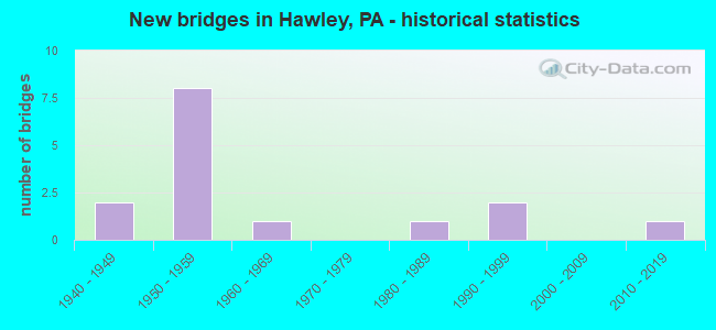
- New bridges - historical statistics
- 21940-1949
- 81950-1959
- 11960-1969
- 11980-1989
- 21990-1999
- 12010-2019

- Reconstructed bridges - Historical Statistics
- 21970-1979
- 11980-1989


- Bridge Condition - Deck
- 16.7%Good
- 41.7%Satisfactory
- 25.0%Fair
- 8.3%Poor
- 8.3%Serious

- Bridge Condition - Superstructure
- 15.4%Very good
- 15.4%Good
- 15.4%Satisfactory
- 46.2%Fair
- 7.7%Poor

- Bridge Condition - Substructure
- 30.8%Good
- 7.7%Satisfactory
- 30.8%Fair
- 23.1%Poor
- 7.7%Serious

- Bridge Condition - Channel
- 7.7%Excellent
- 15.4%Very good
- 23.1%Good
- 15.4%Fair
- 38.5%Poor

- Bridge Condition - Culverts
- 50.0%Satisfactory
- 50.0%Fair
Find on map >> Show street view
Structure Number: 2979, Location: PALMYRA TWP @ JCT TR 590 (Lat: 41.461567, Lng: -75.181458), Route carried "on" structure: US 6, Year Built: 1959, Year Reconstructed: 1984, Status: Open, Structure Length: 10.00m (32.81ft), Average Daily Traffic: 9,834 (year 2020), Truck Traffic: 8%, Average Future Daily Traffic: 16,366 (year 2032), Design Load: HS 20, Features Intersected: WALLENPAUPACK CREEK
Minimum Vertical Clearance: 30+ m (98+ ft), Kilometerpoint: 0.000, Lanes on structure: 2, Base Highway Network: Yes, Owner: State Highway Agency, Approaching Roadway Width: 19.2m (63.0ft), Skew: 21 degrees, Material/Design: Steel continuous, Design/Construction: Stringer/Multi-beam, Number Of Spans In Main Unit: 4, Length of Maximum Span: 27.4m (89.9ft), Curb or Sidewalk Widths: Left: 1.6m (5.2ft), Right: 0.2m (0.7ft), Curb-To-Curb Width: 17.9m (58.7ft), Out-to-Out Width: 20.4m (66.9ft)
Condition: Deck: Satisfactory, Superstructure: Good, Substructure: Fair, Channel: Poor, Operating Rating: 53.5 metric tons, Method Used To Determine Operating Rating: Load Factor (LF), Inventory Rating: 31.8 metric tons, Method Used To Determine Inventory Rating: Load Factor (LF), Structural Evaluation: Somewhat better than minimum adequacy, Deck Geometry: Superior to present desirable criteria, Waterway Adequacy: Superior to present desirable criteria, Approach Roadway Alignment: Equal to present desirable criteria, Length Of Structure Improvement: 10.00m (32.81ft), Designated Inspection Frequency: Every 24 months, Inspection Date: June 2021, Bridge Improvement Cost: $33,000, Roadway Improvement Cost: $100,000, Total Project Cost: $442,000, Deck Structure Type: Concrete Cast-file-Place, Wearing Surface/Protective System: Wearing Surface: Monolithic Concrete, Deck Protection: Epoxy Coated Reinforcing
Find on map >> Show street view
Structure Number: 29791, Location: PALMYRA TWP .1 M E TR 590 (Lat: 41.461667, Lng: -75.190000), Route carried "on" structure: US 6, Year Built: 1959, Status: Open, Structure Length: 1.65m (5.41ft), Average Daily Traffic: 9,834 (year 2020), Truck Traffic: 8%, Average Future Daily Traffic: 16,366 (year 2032), Design Load: HS 20, Features Intersected: PP&L FLUME
Minimum Vertical Clearance: 30+ m (98+ ft), Kilometerpoint: 0.000, Lanes on structure: 2, Base Highway Network: Yes, Owner: State Highway Agency, Approaching Roadway Width: 19.2m (63.0ft), Skew: 25 degrees, Material/Design: Steel, Design/Construction: Stringer/Multi-beam, Number Of Spans In Main Unit: 1, Length of Maximum Span: 16.2m (53.1ft), Curb or Sidewalk Widths: Left: 1.5m (4.9ft), Right: 0.5m (1.6ft), Curb-To-Curb Width: 18.0m (59.1ft), Out-to-Out Width: 20.4m (66.9ft)
Condition: Deck: Serious, Superstructure: Fair, Substructure: Fair, Operating Rating: 51.7 metric tons, Method Used To Determine Operating Rating: Load Factor (LF), Inventory Rating: 30.8 metric tons, Method Used To Determine Inventory Rating: Load Factor (LF), Structural Evaluation: Somewhat better than minimum adequacy, Deck Geometry: Superior to present desirable criteria, Approach Roadway Alignment: Equal to present desirable criteria, Length Of Structure Improvement: 1.60m (5.25ft), Designated Inspection Frequency: Every 24 months, Inspection Date: June 2021, Bridge Improvement Cost: $14,000, Roadway Improvement Cost: $100,000, Total Project Cost: $186,000, Deck Structure Type: Concrete Cast-file-Place, Wearing Surface/Protective System: Wearing Surface: Bituminous
Find on map >> Show street view
Structure Number: 29792, Location: PALMYRA TWP 1 M E TR 507 (Lat: 41.438894, Lng: -75.156564), Route carried "on" structure: US 6, Year Built: 1950, Status: Open, Structure Length: 0.73m (2.40ft), Average Daily Traffic: 5,389 (year 2020), Truck Traffic: 8%, Average Future Daily Traffic: 7,980 (year 2032), Design Load: HS 20, Features Intersected: DECKER CREEK
Minimum Vertical Clearance: 30+ m (98+ ft), Kilometerpoint: 4.064, Lanes on structure: 2, Base Highway Network: Yes, Owner: State Highway Agency, Approaching Roadway Width: 11.9m (39.0ft), Skew: 3 degrees, Material/Design: Concrete, Design/Construction: Slab, Number Of Spans In Main Unit: 1, Length of Maximum Span: 6.1m (20.0ft), Curb-To-Curb Width: 11.7m (38.4ft), Out-to-Out Width: 12.8m (42.0ft)
Condition: Deck: Satisfactory, Superstructure: Fair, Substructure: Poor, Channel: Poor, Operating Rating: 49.0 metric tons, Method Used To Determine Operating Rating: Field evaluation and documented engineering judgment, Inventory Rating: 32.7 metric tons, Method Used To Determine Inventory Rating: Field evaluation and documented engineering judgment, Structural Evaluation: Meets minimum limits, Deck Geometry: Somewhat better than minimum adequacy, Waterway Adequacy: Equal to present minimum criteria, Approach Roadway Alignment: Equal to present desirable criteria, Length Of Structure Improvement: 0.70m (2.30ft), Designated Inspection Frequency: Every 24 months, Inspection Date: June 2021, Bridge Improvement Cost: $13,000, Roadway Improvement Cost: $100,000, Total Project Cost: $173,000, Wearing Surface/Protective System: Wearing Surface: Bituminous
Find on map >> Show street view
Structure Number: 29922, Location: LACKAWAX TWP 64' E SR4010 (Lat: 41.489003, Lng: -75.154044), Route carried "on" structure: State highway 590, Year Built: 1958, Status: Open, Structure Length: 1.19m (3.90ft), Average Daily Traffic: 2,646 (year 2020), Truck Traffic: 6%, Average Future Daily Traffic: 4,810 (year 2032), Design Load: HS 20, Features Intersected: SWAMP BROOK CREEK
Minimum Vertical Clearance: 30+ m (98+ ft), Kilometerpoint: 1.370, Lanes on structure: 2, Owner: State Highway Agency, Approaching Roadway Width: 7.0m (23.0ft), Skew: 1 degrees, Material/Design: Concrete, Design/Construction: Tee Beam, Number Of Spans In Main Unit: 1, Length of Maximum Span: 11.6m (38.1ft), Out-to-Out Width: 17.6m (57.7ft)
Condition: Superstructure: Satisfactory, Substructure: Poor, Channel: Poor, Operating Rating: 83.5 metric tons, Method Used To Determine Operating Rating: Load Factor (LF), Inventory Rating: 49.9 metric tons, Method Used To Determine Inventory Rating: Load Factor (LF), Structural Evaluation: Meets minimum limits, Waterway Adequacy: Superior to present desirable criteria, Approach Roadway Alignment: Equal to present desirable criteria, Length Of Structure Improvement: 1.80m (5.91ft), Designated Inspection Frequency: Every 24 months, Inspection Date: June 2021, Bridge Improvement Cost: $16,000, Roadway Improvement Cost: $47,000, Total Project Cost: $215,000
Find on map >> Show street view
Structure Number: 29923, Location: LACKAWAX TP .7M N SR 4006 (Lat: 41.483117, Lng: -75.162194), Route carried "on" structure: State highway 590, Year Built: 1958, Status: Open, Structure Length: 0.70m (2.30ft), Average Daily Traffic: 2,646 (year 2020), Truck Traffic: 6%, Average Future Daily Traffic: 4,810 (year 2032), Design Load: HS 20, Features Intersected: TINKWIG CREEK
Minimum Vertical Clearance: 30+ m (98+ ft), Kilometerpoint: 3.825, Lanes on structure: 2, Owner: State Highway Agency, Approaching Roadway Width: 6.1m (20.0ft), Skew: 4 degrees, Material/Design: Steel, Design/Construction: Culvert, Number Of Spans In Main Unit: 1, Length of Maximum Span: 7.0m (23.0ft)
Condition: Channel: Fair, Culverts: Fair, Operating Rating: 49.0 metric tons, Method Used To Determine Operating Rating: Field evaluation and documented engineering judgment, Inventory Rating: 32.7 metric tons, Method Used To Determine Inventory Rating: Field evaluation and documented engineering judgment, Structural Evaluation: Somewhat better than minimum adequacy, Waterway Adequacy: Equal to present minimum criteria, Approach Roadway Alignment: Equal to present desirable criteria, Length Of Structure Improvement: 0.50m (1.64ft), Designated Inspection Frequency: Every 24 months, Inspection Date: June 2021, Bridge Improvement Cost: $22,000, Roadway Improvement Cost: $100,000, Total Project Cost: $299,000
Find on map >> Show street view
Structure Number: 30009, Location: LACKAWAXEN TP 6M S TR 590 (Lat: 41.483228, Lng: -75.136944), Route carried "on" structure: State highway , Year Built: 1957, Status: Open, Structure Length: 0.70m (2.30ft), Average Daily Traffic: 185 (year 2022), Truck Traffic: 9%, Average Future Daily Traffic: 304 (year 2032), Design Load: HS 20, Features Intersected: TINKWIG CREEK, Facility Carried by Structure: SR 4006
Minimum Vertical Clearance: 30+ m (98+ ft), Kilometerpoint: 0.871, Lanes on structure: 2, Owner: State Highway Agency, Approaching Roadway Width: 6.1m (20.0ft), Skew: 3 degrees, Material/Design: Concrete, Design/Construction: Culvert, Number Of Spans In Main Unit: 1, Length of Maximum Span: 7.0m (23.0ft)
Condition: Channel: Fair, Culverts: Satisfactory, Operating Rating: 49.0 metric tons, Method Used To Determine Operating Rating: Field evaluation and documented engineering judgment, Inventory Rating: 32.7 metric tons, Method Used To Determine Inventory Rating: Field evaluation and documented engineering judgment, Structural Evaluation: Equal to present minimum criteria, Waterway Adequacy: Superior to present desirable criteria, Approach Roadway Alignment: Equal to present desirable criteria, Length Of Structure Improvement: 0.70m (2.30ft), Designated Inspection Frequency: Every 48 months, Inspection Date: June 2019, Bridge Improvement Cost: $18,000, Roadway Improvement Cost: $100,000, Total Project Cost: $246,000
Find on map >> Show street view
Structure Number: 30036, Location: KIMBLES @ HYDROELECTRIC (Lat: 41.467044, Lng: -75.122794), Route carried "on" structure: City street , Year Built: 1961, Status: Closed, Structure Length: 3.81m (12.50ft), Average Daily Traffic: 50 (year 2010), Average Future Daily Traffic: 100 (year 2020), Design Load: HS 20, Features Intersected: LACKAWAXEN RIVER, Facility Carried by Structure: KIMBLES ROAD
Minimum Vertical Clearance: 30+ m (98+ ft), Kilometerpoint: 0.000, Lanes on structure: 2, Owner: County Highway Agency, Approaching Roadway Width: 5.5m (18.0ft), Material/Design: Steel, Design/Construction: Stringer/Multi-beam, Number Of Spans In Main Unit: 1, Length of Maximum Span: 30.8m (101.0ft), Curb or Sidewalk Widths: Left: 0.2m (0.7ft), Right: 0.2m (0.7ft), Curb-To-Curb Width: 5.5m (18.0ft), Out-to-Out Width: 6.8m (22.3ft)
Condition: Deck: Satisfactory, Superstructure: Satisfactory, Substructure: Serious, Channel: Excellent, Operating Rating: 88.9 metric tons, Method Used To Determine Operating Rating: Load Factor (LF), Inventory Rating: 76.2 metric tons, Method Used To Determine Inventory Rating: Load Factor (LF), Structural Evaluation: High priority of corrective action, Deck Geometry: Meets minimum limits, Waterway Adequacy: Superior to present desirable criteria, Approach Roadway Alignment: Meets minimum limits, Length Of Structure Improvement: 4.80m (15.75ft), Designated Inspection Frequency: Every 24 months, Other Special Inspection Frequency: Every 12 months, Inspection Date: September 2019, Other Special Inspection Date: September 2020, Deck Structure Type: Concrete Cast-file-Place, Wearing Surface/Protective System: Wearing Surface: Bituminous
Find on map >> Show street view
Structure Number: 30041, Location: 200' S OF KIMBLES RD (Lat: 41.464514, Lng: -75.126769), Route carried "on" structure: City street , Year Built: 1956, Status: Posted for load, Structure Length: 1.01m (3.31ft), Average Daily Traffic: 50 (year 2013), Average Future Daily Traffic: 70 (year 2033), Design Load: HS 20, Features Intersected: DECKER CREEK, Facility Carried by Structure: T406 HENDERSHOT RD
Minimum Vertical Clearance: 30+ m (98+ ft), Kilometerpoint: 0.000, Lanes on structure: 2, Owner: Town or Township Highway Agency, Approaching Roadway Width: 3.7m (12.1ft), Material/Design: Prestressed concrete, Design/Construction: Box Beam or Girders - Multiple, Number Of Spans In Main Unit: 1, Length of Maximum Span: 9.8m (32.2ft), Curb or Sidewalk Widths: Left: 0.2m (0.7ft), Right: 0.2m (0.7ft), Curb-To-Curb Width: 6.9m (22.6ft), Out-to-Out Width: 7.4m (24.3ft)
Condition: Deck: Poor, Superstructure: Poor, Substructure: Poor, Channel: Poor, Operating Rating: 26.3 metric tons, Method Used To Determine Operating Rating: Load Factor (LF), Inventory Rating: 15.4 metric tons, Method Used To Determine Inventory Rating: Load Factor (LF), Structural Evaluation: Meets minimum limits, Deck Geometry: Somewhat better than minimum adequacy, Waterway Adequacy: Better than present minimum criteria, Approach Roadway Alignment: Equal to present desirable criteria, Bridge Posting: Required (Relationship of Operating Rating to Maximum Legal Load: 30.0 - 39.9% below), Length Of Structure Improvement: 1.60m (5.25ft), Designated Inspection Frequency: Every 24 months, Other Special Inspection Frequency: Every 6 months, Inspection Date: September 2019, Other Special Inspection Date: March 2021, Bridge Improvement Cost: $8,000, Roadway Improvement Cost: $23,000, Total Project Cost: $107,000, Deck Structure Type: Other, Wearing Surface/Protective System: Wearing Surface: Bituminous
Find on map >> Show street view
Structure Number: 3006, Location: 2000 FT SW OF SR 4006 (Lat: 41.465422, Lng: -75.125814), Route carried "on" structure: City street , Year Built: 1987, Status: Open, Structure Length: 1.92m (6.30ft), Average Daily Traffic: 75 (year 2013), Average Future Daily Traffic: 100 (year 2033), Design Load: HS 20, Features Intersected: STOURBRIDGE RAILROAD, Facility Carried by Structure: T-367 KIMBLES RD
Minimum Vertical Clearance: 30+ m (98+ ft), Kilometerpoint: 0.000, Lanes on structure: 2, Owner: Town or Township Highway Agency, Approaching Roadway Width: 6.7m (22.0ft), Material/Design: Prestressed concrete, Design/Construction: Box Beam or Girders - Multiple, Number Of Spans In Main Unit: 1, Length of Maximum Span: 18.9m (62.0ft), Curb or Sidewalk Widths: Left: 0.5m (1.6ft), Right: 0.5m (1.6ft), Curb-To-Curb Width: 7.6m (24.9ft), Out-to-Out Width: 8.7m (28.5ft)
Condition: Deck: Fair, Superstructure: Fair, Substructure: Good, Operating Rating: 65.3 metric tons, Method Used To Determine Operating Rating: Load Factor (LF), Inventory Rating: 26.3 metric tons, Method Used To Determine Inventory Rating: Load Factor (LF), Structural Evaluation: Somewhat better than minimum adequacy, Deck Geometry: Equal to present minimum criteria, Underclear: High priority of corrective action, Approach Roadway Alignment: Equal to present desirable criteria, Length Of Structure Improvement: 2.60m (8.53ft), Designated Inspection Frequency: Every 24 months, Inspection Date: September 2019, Deck Structure Type: Other, Wearing Surface/Protective System: Wearing Surface: Bituminous
Find on map >> Show street view
Structure Number: 30061, Location: CROMWELLTOWN BRIDGE (Lat: 41.473022, Lng: -75.170775), Route carried "on" structure: City street , Year Built: 1990, Status: Open, Structure Length: 3.02m (9.91ft), Average Daily Traffic: 50 (year 1989), Average Future Daily Traffic: 70 (year 2009), Features Intersected: WALLENPAUPACK CREEK, Facility Carried by Structure: CROMWELL AVENUE
Minimum Vertical Clearance: 30+ m (98+ ft), Kilometerpoint: 0.000, Lanes on structure: 2, Owner: County Highway Agency, Approaching Roadway Width: 6.7m (22.0ft), Material/Design: Prestressed concrete, Design/Construction: Box Beam or Girders - Multiple, Number Of Spans In Main Unit: 1, Length of Maximum Span: 29.6m (97.1ft), Curb or Sidewalk Widths: Left: 0.2m (0.7ft), Right: 0.2m (0.7ft), Curb-To-Curb Width: 8.8m (28.9ft), Out-to-Out Width: 9.8m (32.2ft)
Condition: Deck: Satisfactory, Superstructure: Good, Substructure: Good, Channel: Very good, Operating Rating: 88.9 metric tons, Method Used To Determine Operating Rating: Load Factor (LF), Inventory Rating: 44.5 metric tons, Method Used To Determine Inventory Rating: Load Factor (LF), Structural Evaluation: Better than present minimum criteria, Deck Geometry: Better than present minimum criteria, Waterway Adequacy: Superior to present desirable criteria, Approach Roadway Alignment: Equal to present minimum criteria, Length Of Structure Improvement: 3.70m (12.14ft), Designated Inspection Frequency: Every 24 months, Inspection Date: September 2019, Bridge Improvement Cost: $99,000, Roadway Improvement Cost: $292,000, Total Project Cost: $1,339,000, Deck Structure Type: Concrete Cast-file-Place, Wearing Surface/Protective System: Wearing Surface: Monolithic Concrete, Deck Protection: Epoxy Coated Reinforcing
Find on map >> Show street view
Structure Number: 3543, Location: HAWLEY BORO JCT SR 2004 (Lat: 41.478789, Lng: -75.183981), Route carried "on" structure: US 6, Year Built: 1943, Year Reconstructed: 1982, Status: Open, Structure Length: 5.15m (16.90ft), Average Daily Traffic: 7,333 (year 2022), Truck Traffic: 6%, Average Future Daily Traffic: 11,279 (year 2032), Design Load: HS 20, Features Intersected: LACKAWAXEN RIVER
Minimum Vertical Clearance: 30+ m (98+ ft), Kilometerpoint: 33.326, Lanes on structure: 2, Base Highway Network: Yes, Owner: State Highway Agency, Approaching Roadway Width: 8.5m (27.9ft), Skew: 1 degrees, Material/Design: Concrete, Design/Construction: Tee Beam, Number Of Spans In Main Unit: 3, Length of Maximum Span: 16.5m (54.1ft), Curb or Sidewalk Widths: Left: 1.5m (4.9ft), Right: 0.2m (0.7ft), Curb-To-Curb Width: 8.5m (27.9ft), Out-to-Out Width: 11.0m (36.1ft)
Condition: Deck: Fair, Superstructure: Fair, Substructure: Fair, Channel: Poor, Operating Rating: 37.2 metric tons, Method Used To Determine Operating Rating: Load Factor (LF), Inventory Rating: 15.4 metric tons, Method Used To Determine Inventory Rating: Load Factor (LF), Structural Evaluation: High priority of corrective action, Deck Geometry: High priority of replacement, Waterway Adequacy: Equal to present desirable criteria, Approach Roadway Alignment: Equal to present desirable criteria, Length Of Structure Improvement: 5.20m (17.06ft), Designated Inspection Frequency: Every 24 months, Underwater Inspection Frequency: Every 24 months, Inspection Date: May 2021, Underwater Inspection Date: April 2021, Bridge Improvement Cost: $24,000, Roadway Improvement Cost: $100,000, Total Project Cost: $329,000, Deck Structure Type: Concrete Cast-file-Place, Wearing Surface/Protective System: Wearing Surface: Bituminous, Membrane: Other
Find on map >> Show street view
Structure Number: 35431, Location: HAWLEY BORO RIVER & MAIN (Lat: 41.477433, Lng: -75.183975), Route carried "on" structure: US 6, Year Built: 1958, Status: Open, Structure Length: 1.92m (6.30ft), Average Daily Traffic: 7,902 (year 2020), Truck Traffic: 7%, Average Future Daily Traffic: 12,694 (year 2032), Design Load: HS 20, Features Intersected: MIDDLE CREEK
Minimum Vertical Clearance: 30+ m (98+ ft), Kilometerpoint: 33.326, Lanes on structure: 2, Base Highway Network: Yes, Owner: State Highway Agency, Approaching Roadway Width: 14.0m (45.9ft), Material/Design: Prestressed concrete, Design/Construction: Box Beam or Girders - Multiple, Number Of Spans In Main Unit: 1, Length of Maximum Span: 18.9m (62.0ft), Curb or Sidewalk Widths: Left: 1.5m (4.9ft), Right: 1.5m (4.9ft), Curb-To-Curb Width: 14.0m (45.9ft), Out-to-Out Width: 18.1m (59.4ft)
Condition: Deck: Fair, Superstructure: Fair, Substructure: Satisfactory, Channel: Very good, Operating Rating: 93.4 metric tons, Method Used To Determine Operating Rating: Load Factor (LF), Inventory Rating: 39.0 metric tons, Method Used To Determine Inventory Rating: Load Factor (LF), Structural Evaluation: Somewhat better than minimum adequacy, Deck Geometry: Superior to present desirable criteria, Waterway Adequacy: Equal to present desirable criteria, Approach Roadway Alignment: Equal to present desirable criteria, Length Of Structure Improvement: 2.60m (8.53ft), Designated Inspection Frequency: Every 24 months, Inspection Date: May 2021, Deck Structure Type: Other, Wearing Surface/Protective System: Wearing Surface: Bituminous
Find on map >> Show street view
Structure Number: 35883, Location: Church St Hawley (Lat: 41.476133, Lng: -75.172481), Route carried "on" structure: City street , Year Built: 1945, Year Reconstructed: 1993, Status: Open, Structure Length: 5.82m (19.09ft), Average Daily Traffic: 850 (year 1998), Truck Traffic: 5%, Average Future Daily Traffic: 1,950 (year 1999), Design Load: HS 20, Features Intersected: LACKAWAXEN RIVER, Facility Carried by Structure: CHURCH STREET
Minimum Vertical Clearance: 30+ m (98+ ft), Kilometerpoint: 0.000, Lanes on structure: 2, Owner: County Highway Agency, Approaching Roadway Width: 7.9m (25.9ft), Skew: 2 degrees, Material/Design: Concrete, Design/Construction: Tee Beam, Number Of Spans In Main Unit: 3, Length of Maximum Span: 18.6m (61.0ft), Curb or Sidewalk Widths: Left: 1.6m (5.2ft), Right: 0.2m (0.7ft), Curb-To-Curb Width: 7.9m (25.9ft), Out-to-Out Width: 10.4m (34.1ft)
Condition: Deck: Satisfactory, Superstructure: Fair, Substructure: Fair, Channel: Good, Operating Rating: 49.0 metric tons, Method Used To Determine Operating Rating: Load Factor (LF), Inventory Rating: 29.0 metric tons, Method Used To Determine Inventory Rating: Load Factor (LF), Structural Evaluation: Somewhat better than minimum adequacy, Deck Geometry: Somewhat better than minimum adequacy, Waterway Adequacy: Equal to present desirable criteria, Approach Roadway Alignment: Equal to present desirable criteria, Length Of Structure Improvement: 5.90m (19.36ft), Designated Inspection Frequency: Every 24 months, Inspection Date: September 2019, Bridge Improvement Cost: $65,000, Roadway Improvement Cost: $191,000, Total Project Cost: $875,000, Deck Structure Type: Concrete Cast-file-Place, Wearing Surface/Protective System: Wearing Surface: Monolithic Concrete
Find on map >> Show street view
Structure Number: 40407, Location: PALMYRA TWP 300' W SR2004 (Lat: 41.484797, Lng: -75.221444), Route carried "on" structure: State highway , Year Built: 1998, Status: Open, Structure Length: 3.66m (12.01ft), Average Daily Traffic: 2,657 (year 2022), Truck Traffic: 15%, Average Future Daily Traffic: 3,557 (year 2032), Design Load: HS 25 or greater, Features Intersected: MIDDLE CREEK, Facility Carried by Structure: SR 3028 OWEGO TPK
Minimum Vertical Clearance: 30+ m (98+ ft), Kilometerpoint: 19.043, Lanes on structure: 2, Owner: State Highway Agency, Approaching Roadway Width: 10.1m (33.1ft), Skew: 3 degrees, Material/Design: Prestressed concrete, Design/Construction: Box Beam or Girders - Multiple, Number Of Spans In Main Unit: 1, Length of Maximum Span: 36.3m (119.1ft), Curb or Sidewalk Widths: Left: 0.2m (0.7ft), Right: 0.2m (0.7ft), Curb-To-Curb Width: 10.1m (33.1ft), Out-to-Out Width: 11.3m (37.1ft)
Condition: Deck: Good, Superstructure: Very good, Substructure: Good, Channel: Good, Operating Rating: 88.9 metric tons, Method Used To Determine Operating Rating: Load Factor (LF), Inventory Rating: 53.5 metric tons, Method Used To Determine Inventory Rating: Load Factor (LF), Structural Evaluation: Better than present minimum criteria, Deck Geometry: Meets minimum limits, Waterway Adequacy: Equal to present desirable criteria, Approach Roadway Alignment: Equal to present desirable criteria, Length Of Structure Improvement: 4.60m (15.09ft), Designated Inspection Frequency: Every 48 months, Inspection Date: March 2021, Deck Structure Type: Concrete Cast-file-Place, Wearing Surface/Protective System: Wearing Surface: Monolithic Concrete, Deck Protection: Epoxy Coated Reinforcing
Find on map >> Show street view
Structure Number: 4618, Location: PALMYRA TWP 1 M W TR 6 (Lat: 41.480122, Lng: -75.200789), Route carried "on" structure: State highway , Year Built: 2010, Status: Open, Structure Length: 5.61m (18.41ft), Average Daily Traffic: 748 (year 2022), Truck Traffic: 6%, Average Future Daily Traffic: 1,867 (year 2032), Design Load: HL 93, Features Intersected: MIDDLE CREEK, Facility Carried by Structure: SR 2004
Minimum Vertical Clearance: 30+ m (98+ ft), Kilometerpoint: 1.802, Lanes on structure: 2, Owner: State Highway Agency, Approaching Roadway Width: 8.2m (26.9ft), Skew: 5 degrees, Material/Design: Steel continuous, Design/Construction: Stringer/Multi-beam, Number Of Spans In Main Unit: 2, Length of Maximum Span: 27.4m (89.9ft), Curb-To-Curb Width: 8.5m (27.9ft), Out-to-Out Width: 9.5m (31.2ft)
Condition: Deck: Good, Superstructure: Very good, Substructure: Good, Channel: Good, Operating Rating: 74.4 metric tons, Method Used To Determine Operating Rating: Load and Resistance Factor (LRFR), Inventory Rating: 57.2 metric tons, Method Used To Determine Inventory Rating: Load and Resistance Factor (LRFR), Structural Evaluation: Better than present minimum criteria, Deck Geometry: Somewhat better than minimum adequacy, Waterway Adequacy: Better than present minimum criteria, Approach Roadway Alignment: Equal to present desirable criteria, Designated Inspection Frequency: Every 48 months, Inspection Date: May 2021, Deck Structure Type: Concrete Cast-file-Place, Wearing Surface/Protective System: Wearing Surface: Monolithic Concrete, Deck Protection: Epoxy Coated Reinforcing