Bridge Statistics for Hazel Crest, Illinois (IL)
Condition, Traffic, Stress, Structural Evaluation, Project Costs
- National Bridge Inventory (NBI) Statistics
- 15Number of bridges
- 148ft / 45.2mTotal length
- $2,346,000Total costs
- 662,350Total average daily traffic
- 123,285Total average daily truck traffic
- National Bridge Inventory (NBI) Registered Bridges for Hazel Crest
- No street view available for this location
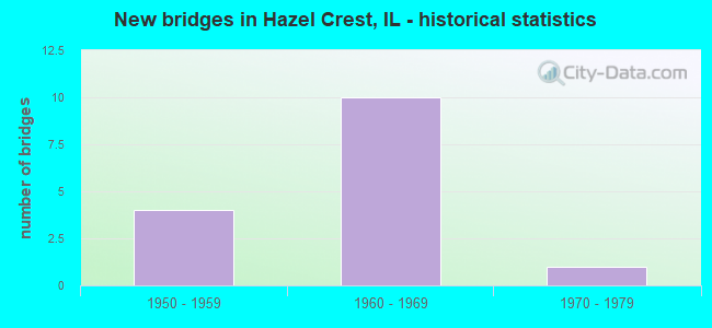
- New bridges - historical statistics
- 41950-1959
- 101960-1969
- 11970-1979
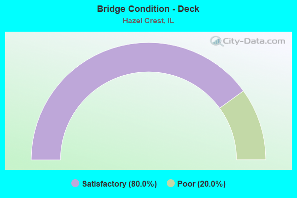
- Bridge Condition - Deck
- 80.0%Satisfactory
- 20.0%Poor
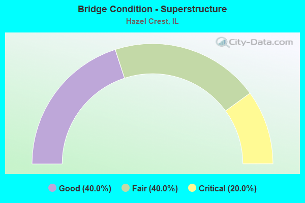
- Bridge Condition - Superstructure
- 40.0%Good
- 40.0%Fair
- 20.0%Critical
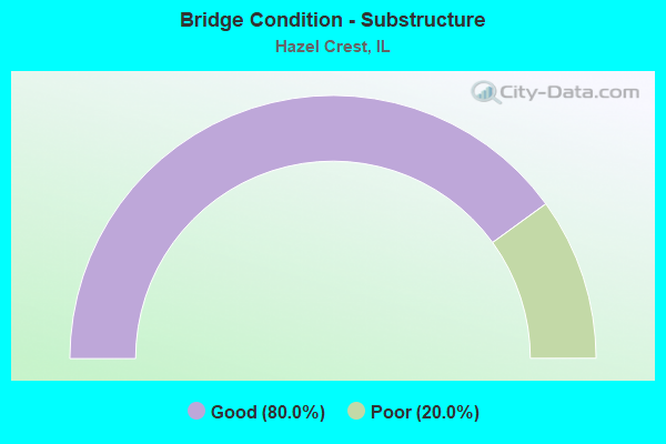
- Bridge Condition - Substructure
- 80.0%Good
- 20.0%Poor
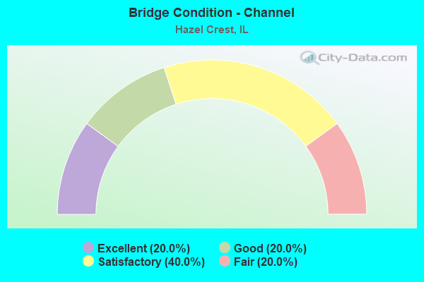
- Bridge Condition - Channel
- 20.0%Excellent
- 20.0%Good
- 40.0%Satisfactory
- 20.0%Fair
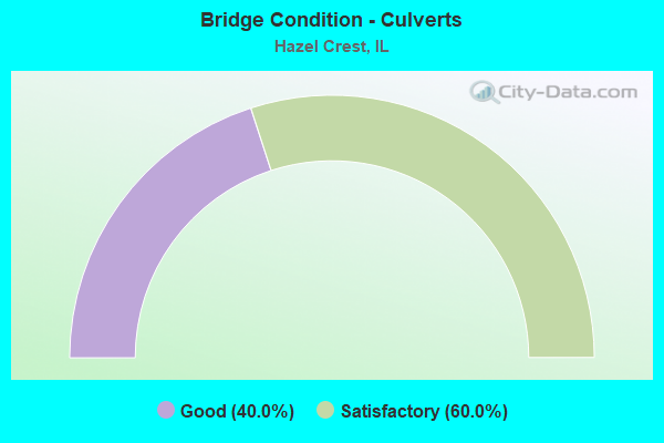
- Bridge Condition - Culverts
- 40.0%Good
- 60.0%Satisfactory
Find on map >> Show street view
Structure Number: 160078, Location: 3.0 M E OF I-57 (Lat: 41.582931, Lng: -87.694808), Route carried "on" structure: Interstate 80, Year Built: 1966, Year Reconstructed: 1997, Status: Open, Structure Length: 5.65m (18.54ft), Average Daily Traffic: 35,750 (year 2021), Truck Traffic: 26%, Average Future Daily Traffic: 60,873 (year 2032), Design Load: HS 20, Features Intersected: KEDZIE AVE
Minimum Vertical Clearance: 30+ m (98+ ft), Kilometerpoint: 248.766, Lanes on structure: 3, Lanes under structure: 4, Base Highway Network: Yes, Owner: State Highway Agency, Approaching Roadway Width: 17.7m (58.1ft), Material/Design: Steel continuous, Design/Construction: Stringer/Multi-beam, Number Of Spans In Main Unit: 4, Length of Maximum Span: 15.6m (51.2ft), Curb-To-Curb Width: 17.7m (58.1ft), Out-to-Out Width: 18.7m (61.4ft)
Condition: Deck: Satisfactory, Superstructure: Fair, Substructure: Good, Operating Rating: 94.3 metric tons, Method Used To Determine Operating Rating: Load Factor (LF) rating reported by rating factor (RF) method using MS18 loading, Inventory Rating: 52.5 metric tons, Method Used To Determine Inventory Rating: Load Factor (LF) rating reported by rating factor (RF) method using MS18 loading, Structural Evaluation: Somewhat better than minimum adequacy, Deck Geometry: Better than present minimum criteria, Underclear: Somewhat better than minimum adequacy, Approach Roadway Alignment: Equal to present desirable criteria, Length Of Structure Improvement: 5.67m (18.60ft), Designated Inspection Frequency: Every 24 months, Inspection Date: December 2020, Bridge Improvement Cost: $782,000, Roadway Improvement Cost: $78,000, Total Project Cost: $1,173,000, Deck Structure Type: Concrete Cast-file-Place, Wearing Surface/Protective System: Deck Protection: Epoxy Coated Reinforcing
Find on map >> Show street view
Structure Number: 160079, Location: 3.0 M E OF I-57 (Lat: 41.582931, Lng: -87.694631), Route carried "on" structure: Interstate 80, Year Built: 1966, Year Reconstructed: 1997, Status: Open, Structure Length: 5.65m (18.54ft), Average Daily Traffic: 35,750 (year 2021), Truck Traffic: 26%, Average Future Daily Traffic: 60,873 (year 2032), Design Load: HS 20, Features Intersected: KEDZIE AVE
Minimum Vertical Clearance: 30+ m (98+ ft), Kilometerpoint: 248.782, Lanes on structure: 3, Lanes under structure: 4, Base Highway Network: Yes, Owner: State Highway Agency, Approaching Roadway Width: 17.7m (58.1ft), Material/Design: Steel continuous, Design/Construction: Stringer/Multi-beam, Number Of Spans In Main Unit: 4, Length of Maximum Span: 15.6m (51.2ft), Curb-To-Curb Width: 17.7m (58.1ft), Out-to-Out Width: 18.7m (61.4ft)
Condition: Deck: Satisfactory, Superstructure: Fair, Substructure: Good, Operating Rating: 94.3 metric tons, Method Used To Determine Operating Rating: Load Factor (LF) rating reported by rating factor (RF) method using MS18 loading, Inventory Rating: 52.5 metric tons, Method Used To Determine Inventory Rating: Load Factor (LF) rating reported by rating factor (RF) method using MS18 loading, Structural Evaluation: Somewhat better than minimum adequacy, Deck Geometry: Better than present minimum criteria, Underclear: Equal to present minimum criteria, Approach Roadway Alignment: Equal to present desirable criteria, Length Of Structure Improvement: 5.67m (18.60ft), Designated Inspection Frequency: Every 24 months, Inspection Date: December 2020, Bridge Improvement Cost: $782,000, Roadway Improvement Cost: $78,000, Total Project Cost: $1,173,000, Deck Structure Type: Concrete Cast-file-Place, Wearing Surface/Protective System: Deck Protection: Epoxy Coated Reinforcing
Find on map >> Show street view
Structure Number: 161232, Location: 0.2 M S OF 175TH (Lat: 41.569236, Lng: -87.681050), Route carried "on" structure: Other road , Year Built: 1975, Status: Open, Structure Length: 0.86m (2.82ft), Average Daily Traffic: 8,800 (year 2018), Truck Traffic: 5%, Average Future Daily Traffic: 8,961 (year 2032), Design Load: HS 20, Features Intersected: DITCH, Facility Carried by Structure: GOVERNORS HWY
Minimum Vertical Clearance: 30+ m (98+ ft), Kilometerpoint: 0.290, Lanes on structure: 4, Base Highway Network: Yes, Owner: State Highway Agency, Approaching Roadway Width: 13.4m (44.0ft), Skew: 2 degrees, Material/Design: Concrete continuous, Design/Construction: Culvert, Number Of Spans In Main Unit: 2, Length of Maximum Span: 3.7m (12.1ft)
Condition: Channel: Fair, Culverts: Satisfactory, Operating Rating: 54.1 metric tons, Method Used To Determine Operating Rating: Load Factor (LF) rating reported by rating factor (RF) method using MS18 loading, Inventory Rating: 32.4 metric tons, Method Used To Determine Inventory Rating: Load Factor (LF) rating reported by rating factor (RF) method using MS18 loading, Structural Evaluation: Equal to present minimum criteria, Waterway Adequacy: Equal to present desirable criteria, Approach Roadway Alignment: Equal to present desirable criteria, Designated Inspection Frequency: Every 24 months, Inspection Date: July 2020
Find on map >> Show street view
Structure Number: 161233, Location: NO OF I80 ADJ 2752 (Lat: 41.584567, Lng: -87.680444), Route carried "on" structure: Other road , Year Built: 1959, Status: Open, Structure Length: 0.91m (2.99ft), Average Daily Traffic: 500 (year 2021), Average Future Daily Traffic: 8,446 (year 2032), Features Intersected: DITCH, Facility Carried by Structure: I- 80 EB TO I-294
Minimum Vertical Clearance: 30+ m (98+ ft), Kilometerpoint: 1.127, Lanes on structure: 1, Base Highway Network: Yes (Inventory Route: 10080040, Subroute: 10), Owner: State Highway Agency, Approaching Roadway Width: 4.9m (16.1ft), Material/Design: Concrete continuous, Design/Construction: Culvert, Number Of Spans In Main Unit: 2, Length of Maximum Span: 4.6m (15.1ft)
Condition: Channel: Good, Culverts: Good, Operating Rating: 54.1 metric tons, Method Used To Determine Operating Rating: Load Factor (LF) rating reported by rating factor (RF) method using MS18 loading, Inventory Rating: 32.4 metric tons, Method Used To Determine Inventory Rating: Load Factor (LF) rating reported by rating factor (RF) method using MS18 loading, Structural Evaluation: Better than present minimum criteria, Waterway Adequacy: Superior to present desirable criteria, Approach Roadway Alignment: Equal to present desirable criteria, Designated Inspection Frequency: Every 24 months, Inspection Date: June 2020
Find on map >> Show street view
Structure Number: 162132, Location: 2.3 M W OF IL-1 (Lat: 41.581969, Lng: -87.681467), Route carried "on" structure: Other road , Year Built: 1968, Status: Open, Structure Length: 14.69m (48.20ft), Average Daily Traffic: 500 (year 2021), Average Future Daily Traffic: 8,446 (year 2032), Design Load: HS 20, Features Intersected: I-294, Facility Carried by Structure: I- 80 EB TO I-294
Minimum Vertical Clearance: 30+ m (98+ ft), Kilometerpoint: 0.531, Lanes on structure: 1, Lanes under structure: 8, Base Highway Network: Yes (Inventory Route: 10080040, Subroute: 10), Owner: State Highway Agency, Approaching Roadway Width: 10.1m (33.1ft), Skew: 1 degrees, Material/Design: Steel continuous, Design/Construction: Stringer/Multi-beam, Number Of Spans In Main Unit: 6, Length of Maximum Span: 34.0m (111.5ft), Curb-To-Curb Width: 8.3m (27.2ft), Out-to-Out Width: 8.9m (29.2ft)
Condition: Deck: Poor, Superstructure: Critical, Substructure: Poor, Operating Rating: 39.5 metric tons, Method Used To Determine Operating Rating: Load Factor (LF) rating reported by rating factor (RF) method using MS18 loading, Inventory Rating: 23.7 metric tons, Method Used To Determine Inventory Rating: Load Factor (LF) rating reported by rating factor (RF) method using MS18 loading, Structural Evaluation: High priority of replacement, Deck Geometry: Somewhat better than minimum adequacy, Underclear: High priority of corrective action, Approach Roadway Alignment: High priority of corrective action, Designated Inspection Frequency: Every 12 months, Other Special Inspection Frequency: Every 6 months, Inspection Date: July 2021, Other Special Inspection Date: January 2022, Deck Structure Type: Concrete Cast-file-Place, Wearing Surface/Protective System: Wearing Surface: Other
Find on map >> Show street view
Structure Number: 162752, Location: 0.1 M N I-80 (Lat: 41.584194, Lng: -87.680892), Route carried "on" structure: Interstate 294, Year Built: 1958, Status: Open, Structure Length: 0.95m (3.12ft), Average Daily Traffic: 92,400 (year 2020), Truck Traffic: 14%, Average Future Daily Traffic: 90,022 (year 2032), Design Load: HS 20, Features Intersected: STREAM
Minimum Vertical Clearance: 30+ m (98+ ft), Kilometerpoint: 76.410, Lanes on structure: 6, Base Highway Network: Yes, Toll: On toll road, Owner: State Highway Agency, Approaching Roadway Width: 36.6m (120.1ft), Skew: 3 degrees, Material/Design: Concrete continuous, Design/Construction: Culvert, Number Of Spans In Main Unit: 2, Length of Maximum Span: 3.7m (12.1ft)
Condition: Channel: Satisfactory, Culverts: Satisfactory, Operating Rating: 97.2 metric tons, Method Used To Determine Operating Rating: Load Factor (LF) rating reported by rating factor (RF) method using MS18 loading, Inventory Rating: 75.2 metric tons, Method Used To Determine Inventory Rating: Load Factor (LF) rating reported by rating factor (RF) method using MS18 loading, Structural Evaluation: Equal to present minimum criteria, Waterway Adequacy: Superior to present desirable criteria, Approach Roadway Alignment: Equal to present desirable criteria, Designated Inspection Frequency: Every 24 months, Inspection Date: July 2020
Find on map >> Show street view
Structure Number: 162753, Location: I80 & I294 "Y" (Lat: 41.579217, Lng: -87.676300), Route carried "on" structure: Interstate 294, Year Built: 1958, Status: Open, Structure Length: 1.22m (4.00ft), Average Daily Traffic: 92,400 (year 2020), Truck Traffic: 14%, Average Future Daily Traffic: 90,022 (year 2032), Design Load: HS 20, Features Intersected: STREAM
Minimum Vertical Clearance: 30+ m (98+ ft), Kilometerpoint: 76.892, Lanes on structure: 6, Base Highway Network: Yes, Toll: On toll road, Owner: State Toll Authority, Approaching Roadway Width: 36.6m (120.1ft), Material/Design: Concrete, Design/Construction: Culvert, Number Of Spans In Main Unit: 3, Length of Maximum Span: 3.7m (12.1ft)
Condition: Channel: Excellent, Culverts: Satisfactory, Operating Rating: 97.2 metric tons, Method Used To Determine Operating Rating: Load Factor (LF) rating reported by rating factor (RF) method using MS18 loading, Inventory Rating: 63.2 metric tons, Method Used To Determine Inventory Rating: Load Factor (LF) rating reported by rating factor (RF) method using MS18 loading, Structural Evaluation: Equal to present minimum criteria, Waterway Adequacy: Superior to present desirable criteria, Approach Roadway Alignment: Equal to present desirable criteria, Designated Inspection Frequency: Every 24 months, Inspection Date: May 2019, Deck Structure Type: Concrete Cast-file-Place
Find on map >> Show street view
Structure Number: 162841, Location: 600 FT. W I-294 (Lat: 41.582711, Lng: -87.684850), Route carried "on" structure: Other road , Year Built: 1958, Status: Open, Structure Length: 0.82m (2.69ft), Average Daily Traffic: 500 (year 2021), Average Future Daily Traffic: 8,446 (year 2032), Design Load: HS 20, Features Intersected: DITCH, Facility Carried by Structure: I-80 EB TO I-294 N
Minimum Vertical Clearance: 30+ m (98+ ft), Kilometerpoint: 0.241, Lanes on structure: 1, Base Highway Network: Yes (Inventory Route: 10080040, Subroute: 10), Owner: State Toll Authority, Approaching Roadway Width: 9.8m (32.2ft), Material/Design: Concrete, Design/Construction: Culvert, Number Of Spans In Main Unit: 2, Length of Maximum Span: 4.0m (13.1ft)
Condition: Channel: Satisfactory, Culverts: Good, Operating Rating: 97.2 metric tons, Method Used To Determine Operating Rating: Load Factor (LF) rating reported by rating factor (RF) method using MS18 loading, Inventory Rating: 97.2 metric tons, Method Used To Determine Inventory Rating: Load Factor (LF) rating reported by rating factor (RF) method using MS18 loading, Structural Evaluation: Better than present minimum criteria, Waterway Adequacy: Superior to present desirable criteria, Approach Roadway Alignment: Equal to present desirable criteria, Designated Inspection Frequency: Every 24 months, Inspection Date: May 2019
Find on map >> Show street view
Structure Number: 169705, Location: I-80 & I294 P3 (Lat: 41.581686, Lng: -87.681450), Route carried "on" structure: Interstate 80, Year Built: 1966, Status: Open, Structure Length: 5.79m (19.00ft), Average Daily Traffic: 35,200 (year 2021), Truck Traffic: 21%, Average Future Daily Traffic: 46,556 (year 2032), Design Load: HS 20+Mod, Features Intersected: I 294
Minimum Vertical Clearance: 30+ m (98+ ft), Kilometerpoint: 249.956, Lanes on structure: 3, Lanes under structure: 6, Base Highway Network: Yes, Toll: On toll road, Owner: State Toll Authority, Approaching Roadway Width: 20.7m (67.9ft), Material/Design: Steel, Design/Construction: Stringer/Multi-beam, Number Of Spans In Main Unit: 4, Length of Maximum Span: 22.3m (73.2ft), Curb-To-Curb Width: 16.5m (54.1ft), Out-to-Out Width: 17.7m (58.1ft)
Condition: Deck: Satisfactory, Superstructure: Good, Substructure: Good, Operating Rating: 72.9 metric tons, Method Used To Determine Operating Rating: Load Factor (LF) rating reported by rating factor (RF) method using MS18 loading, Inventory Rating: 43.7 metric tons, Method Used To Determine Inventory Rating: Load Factor (LF) rating reported by rating factor (RF) method using MS18 loading, Structural Evaluation: Better than present minimum criteria, Deck Geometry: Equal to present minimum criteria, Underclear: High priority of corrective action, Approach Roadway Alignment: Equal to present desirable criteria, Designated Inspection Frequency: Every 24 months, Inspection Date: April 2020, Deck Structure Type: Concrete Cast-file-Place
Find on map >> Show street view
Structure Number: 169999, Location: 2.0 M W OF IL-1 (Lat: 41.579022, Lng: -87.675861), Route carried "on" structure: Other road , Year Built: 1962, Status: Open, Structure Length: 8.69m (28.51ft), Average Daily Traffic: 1,650 (year 2014), Truck Traffic: 13%, Average Future Daily Traffic: 1,803 (year 2032), Design Load: HS 20, Features Intersected: I-80/294, Facility Carried by Structure: 171ST ST
Minimum Vertical Clearance: 30+ m (98+ ft), Kilometerpoint: 0.789, Lanes on structure: 2, Lanes under structure: 6, Owner: City or Municipal Highway Agency, Approaching Roadway Width: 6.1m (20.0ft), Material/Design: Steel, Design/Construction: Stringer/Multi-beam, Number Of Spans In Main Unit: 4, Length of Maximum Span: 26.8m (87.9ft), Curb or Sidewalk Widths: Left: 1.5m (4.9ft), Right: 1.5m (4.9ft), Curb-To-Curb Width: 9.1m (29.9ft), Out-to-Out Width: 12.8m (42.0ft)
Condition: Deck: Satisfactory, Superstructure: Good, Substructure: Good, Operating Rating: 71.3 metric tons, Method Used To Determine Operating Rating: Load Factor (LF) rating reported by rating factor (RF) method using MS18 loading, Inventory Rating: 42.8 metric tons, Method Used To Determine Inventory Rating: Load Factor (LF) rating reported by rating factor (RF) method using MS18 loading, Structural Evaluation: Better than present minimum criteria, Deck Geometry: Somewhat better than minimum adequacy, Underclear: Equal to present minimum criteria, Approach Roadway Alignment: Somewhat better than minimum adequacy, Designated Inspection Frequency: Every 24 months, Inspection Date: April 2020, Deck Structure Type: Concrete Cast-file-Place
Find on map >> Show street view
Structure Number: 160078, Location: 3.0 M E OF I-57 (Lat: 41.582822, Lng: -87.694447), Route carried "under" structure: Other road , Year Built: 1966, Structure Length: 0. m, Average Daily Traffic: 21,500 (year 2018), Truck Traffic: 4%, Features Intersected: KEDZIE AVE, Facility Carried by Structure: I- 80 EB
Minimum Vertical Clearance: 4.39m (14.40ft), Kilometerpoint: 45.688, Lanes on structure: 3, Lanes under structure: 4, Material/Design: Steel continuous, Design/Construction: Stringer/Multi-beam, Length of Maximum Span: 15.6m (51.2ft)
Find on map >> Show street view
Structure Number: 160079, Location: 3.0 M E OF I-57 (Lat: 41.583142, Lng: -87.694458), Route carried "under" structure: Other road , Year Built: 1966, Structure Length: 0. m, Average Daily Traffic: 21,500 (year 2018), Truck Traffic: 4%, Features Intersected: KEDZIE AVE, Facility Carried by Structure: I- 80 WB
Minimum Vertical Clearance: 4.52m (14.83ft), Kilometerpoint: 45.656, Lanes on structure: 3, Lanes under structure: 4, Material/Design: Steel continuous, Design/Construction: Stringer/Multi-beam, Length of Maximum Span: 15.6m (51.2ft)
Find on map >> Show street view
Structure Number: 162132, Location: 2.3 M W OF IL-1 (Lat: 41.580778, Lng: -87.679447), Route carried "under" structure: Interstate 80, Year Built: 1968, Structure Length: 0. m, Average Daily Traffic: 70,400 (year 2021), Truck Traffic: 21%, Features Intersected: I-294
Minimum Vertical Clearance: 7.62m (25.00ft), Kilometerpoint: 250.133, Lanes on structure: 1, Lanes under structure: 8, Material/Design: Steel continuous, Design/Construction: Stringer/Multi-beam, Length of Maximum Span: 34.0m (111.5ft)
Find on map >> Show street view
Structure Number: 169705, Location: I-80 & I294 P3 (Lat: 41.580872, Lng: -87.678750), Route carried "under" structure: Interstate 294, Year Built: 1966, Structure Length: 0. m, Average Daily Traffic: 92,400 (year 2020), Truck Traffic: 14%, Features Intersected: I 294, Facility Carried by Structure: I-80 WB
Minimum Vertical Clearance: 5.08m (16.67ft), Kilometerpoint: 76.683, Lanes on structure: 3, Lanes under structure: 6, Toll: On toll road, Material/Design: Steel, Design/Construction: Stringer/Multi-beam, Length of Maximum Span: 22.3m (73.2ft)
Find on map >> Show street view
Structure Number: 169999, Location: 2.0 M W OF IL-1 (Lat: 41.578897, Lng: -87.676017), Route carried "under" structure: Interstate 80, Year Built: 1962, Structure Length: 0. m, Average Daily Traffic: 153,100 (year 2020), Truck Traffic: 27%, Features Intersected: I-80/294, Facility Carried by Structure: 171ST ST
Minimum Vertical Clearance: 5.33m (17.49ft), Kilometerpoint: 250.455, Lanes on structure: 2, Lanes under structure: 6, Material/Design: Steel, Design/Construction: Stringer/Multi-beam, Length of Maximum Span: 26.8m (87.9ft)