Bridge Statistics for Hazel Park, Michigan (MI)
Condition, Traffic, Stress, Structural Evaluation, Project Costs
- National Bridge Inventory (NBI) Statistics
- 18Number of bridges
- 141ft / 42.5mTotal length
- $284,000Total costs
- 1,947,600Total average daily traffic
- 134,009Total average daily truck traffic
- National Bridge Inventory (NBI) Registered Bridges for Hazel Park
- No street view available for this location
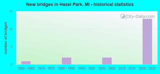
- New bridges - historical statistics
- 11960-1969
- 21980-1989
- 22000-2009
- 132020-2022
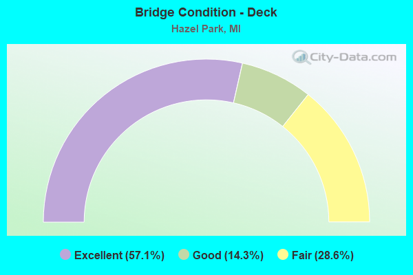
- Bridge Condition - Deck
- 57.1%Excellent
- 14.3%Good
- 28.6%Fair
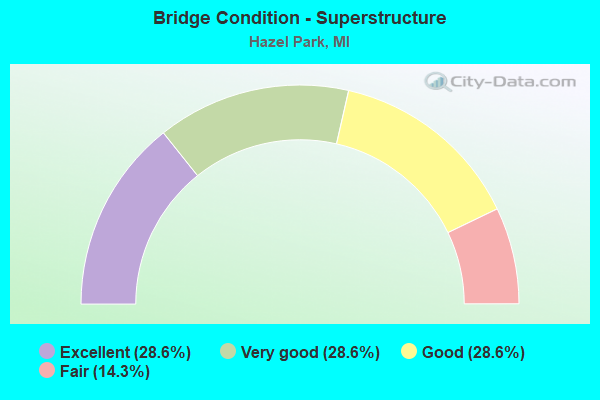
- Bridge Condition - Superstructure
- 28.6%Excellent
- 28.6%Very good
- 28.6%Good
- 14.3%Fair
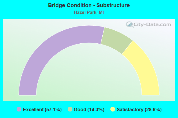
- Bridge Condition - Substructure
- 57.1%Excellent
- 14.3%Good
- 28.6%Satisfactory
Find on map >> Show street view
Structure Number: 805, Location: 1.5 MI SE OF HARBERT (Lat: 41.863756, Lng: -86.609675), Route carried "on" structure: County highway 1121, Year Built: 1960, Status: Open, Structure Length: 7.89m (25.89ft), Average Daily Traffic: 3,740 (year 1990), Truck Traffic: 3%, Average Future Daily Traffic: 24,900 (year 2025), Design Load: H 20, Features Intersected: I-94, Facility Carried by Structure: THREE OAKS ROAD
Minimum Vertical Clearance: 30.48m (100.00ft), Kilometerpoint: 11.176, Lanes on structure: 2, Lanes under structure: 6, Owner: State Highway Agency, Approaching Roadway Width: 7.0m (23.0ft), Skew: 3 degrees, Material/Design: Steel, Design/Construction: Stringer/Multi-beam, Number Of Spans In Main Unit: 4, Length of Maximum Span: 26.8m (87.9ft), Curb-To-Curb Width: 9.6m (31.5ft), Out-to-Out Width: 10.6m (34.8ft)
Condition: Deck: Fair, Superstructure: Fair, Substructure: Satisfactory, Operating Rating: 52.5 metric tons, Method Used To Determine Operating Rating: Load Factor (LF) rating reported by rating factor (RF) method using MS18 loading, Inventory Rating: 31.4 metric tons, Method Used To Determine Inventory Rating: Load Factor (LF) rating reported by rating factor (RF) method using MS18 loading, Structural Evaluation: Somewhat better than minimum adequacy, Deck Geometry: Meets minimum limits, Underclear: Meets minimum limits, Approach Roadway Alignment: Better than present minimum criteria, Length Of Structure Improvement: 7.90m (25.92ft), Designated Inspection Frequency: Every 24 months, Inspection Date: July 2020, Bridge Improvement Cost: $99,000, Roadway Improvement Cost: $8,000, Total Project Cost: $98,000, Deck Structure Type: Concrete Cast-file-Place, Wearing Surface/Protective System: Wearing Surface: Latex Concrete
Find on map >> Show street view
Structure Number: 7962, Location: IN FERNDALE (Lat: 42.475875, Lng: -83.114886), Route carried "on" structure: Interstate 696, Year Built: 1982, Status: Open, Structure Length: 2.45m (8.04ft), Average Daily Traffic: 91,000 (year 1995), Truck Traffic: 5%, Average Future Daily Traffic: 105,155 (year 2015), Design Load: HS 25 or greater, Features Intersected: N-S SERVICE ROAD
Minimum Vertical Clearance: 30.48m (100.00ft), Kilometerpoint: 0.211, Lanes on structure: 2, Lanes under structure: 2, Base Highway Network: Yes (Inventory Route: 71, Subroute: 2), Owner: State Highway Agency, Approaching Roadway Width: 15.2m (49.9ft), Skew: 6 degrees, Material/Design: Steel, Design/Construction: Stringer/Multi-beam, Number Of Spans In Main Unit: 1, Length of Maximum Span: 24.3m (79.7ft), Curb-To-Curb Width: 14.7m (48.2ft), Out-to-Out Width: 15.9m (52.2ft)
Condition: Deck: Fair, Superstructure: Good, Substructure: Satisfactory, Operating Rating: 74.8 metric tons, Method Used To Determine Operating Rating: Load Factor (LF) rating reported by rating factor (RF) method using MS18 loading, Inventory Rating: 45.0 metric tons, Method Used To Determine Inventory Rating: Load Factor (LF) rating reported by rating factor (RF) method using MS18 loading, Structural Evaluation: Equal to present minimum criteria, Deck Geometry: Superior to present desirable criteria, Underclear: Meets minimum limits, Approach Roadway Alignment: Equal to present desirable criteria, Designated Inspection Frequency: Every 24 months, Inspection Date: July 2021, Deck Structure Type: Concrete Cast-file-Place, Wearing Surface/Protective System: Wearing Surface: Epoxy Overlay, Deck Protection: Epoxy Coated Reinforcing
Find on map >> Show street view
Structure Number: 7965, Location: IN HAZEL PARK (Lat: 42.473256, Lng: -83.110461), Route carried "on" structure: City street , Year Built: 2021, Status: Open, Structure Length: 7.10m (23.29ft), Average Daily Traffic: 11,000 (year 1977), Average Future Daily Traffic: 11,000 (year 1977), Design Load: Greater than HL93, Features Intersected: I-75, Facility Carried by Structure: SHEVLIN DBL U TURN
Minimum Vertical Clearance: 30.48m (100.00ft), Kilometerpoint: 0.060, Lanes on structure: 2, Lanes under structure: 10, Owner: State Highway Agency, Approaching Roadway Width: 15.2m (49.9ft), Skew: 30 degrees, Material/Design: Prestressed concrete, Design/Construction: Stringer/Multi-beam, Number Of Spans In Main Unit: 2, Length of Maximum Span: 37.2m (122.0ft), Curb-To-Curb Width: 23.4m (76.8ft), Out-to-Out Width: 30.2m (99.1ft)
Condition: Deck: Excellent, Superstructure: Very good, Substructure: Excellent, Operating Rating: 56.4 metric tons, Method Used To Determine Operating Rating: Load and Resistance Factor Rating (LRFR) rating reported by rating factor(RF) method using HL-93 loadings, Inventory Rating: 39.9 metric tons, Method Used To Determine Inventory Rating: Load and Resistance Factor Rating (LRFR) rating reported by rating factor(RF) method using HL-93 loadings, Structural Evaluation: Equal to present desirable criteria, Deck Geometry: Superior to present desirable criteria, Underclear: Meets minimum limits, Approach Roadway Alignment: Equal to present desirable criteria, Length Of Structure Improvement: 6.55m (21.49ft), Designated Inspection Frequency: Every 24 months, Inspection Date: June 2021, Bridge Improvement Cost: $280,000, Roadway Improvement Cost: $16,000, Total Project Cost: $186,000, Deck Structure Type: Concrete Cast-file-Place, Wearing Surface/Protective System: Wearing Surface: Monolithic Concrete, Deck Protection: Epoxy Coated Reinforcing
Find on map >> Show street view
Structure Number: 8091, Location: IN HAZEL PARK (Lat: 42.454792, Lng: -83.095453), Route carried "on" structure: City street , Year Built: 2020, Status: Open, Structure Length: 5.81m (19.06ft), Average Daily Traffic: 2,570 (year 1974), Average Future Daily Traffic: 2,570 (year 1977), Design Load: Greater than HL93, Features Intersected: I-75, Facility Carried by Structure: MYERS RD
Minimum Vertical Clearance: 30.48m (100.00ft), Kilometerpoint: 1.207, Lanes on structure: 2, Lanes under structure: 10, Owner: State Highway Agency, Approaching Roadway Width: 8.5m (27.9ft), Skew: 1 degrees, Material/Design: Prestressed concrete, Design/Construction: Stringer/Multi-beam, Number Of Spans In Main Unit: 2, Length of Maximum Span: 29.3m (96.1ft), Curb or Sidewalk Widths: Left: 1.8m (5.9ft), Right: 1.8m (5.9ft), Curb-To-Curb Width: 8.5m (27.9ft), Out-to-Out Width: 13.0m (42.7ft)
Condition: Deck: Excellent, Superstructure: Excellent, Substructure: Excellent, Operating Rating: 57.0 metric tons, Method Used To Determine Operating Rating: Load and Resistance Factor Rating (LRFR) rating reported by rating factor(RF) method using HL-93 loadings, Inventory Rating: 43.7 metric tons, Method Used To Determine Inventory Rating: Load and Resistance Factor Rating (LRFR) rating reported by rating factor(RF) method using HL-93 loadings, Structural Evaluation: Superior to present desirable criteria, Deck Geometry: Meets minimum limits, Underclear: High priority of corrective action, Approach Roadway Alignment: Equal to present desirable criteria, Designated Inspection Frequency: Every 24 months, Inspection Date: August 2020, Deck Structure Type: Concrete Cast-file-Place, Wearing Surface/Protective System: Wearing Surface: Monolithic Concrete, Deck Protection: Epoxy Coated Reinforcing
Find on map >> Show street view
Structure Number: 8093, Location: IN HAZEL PARK (Lat: 42.459069, Lng: -83.103767), Route carried "on" structure: City street 2059, Year Built: 2020, Status: Open, Structure Length: 7.67m (25.16ft), Average Daily Traffic: 14,500 (year 1974), Truck Traffic: 3%, Average Future Daily Traffic: 14,500 (year 1977), Design Load: Greater than HL93, Features Intersected: I-75, Facility Carried by Structure: JOHN R
Minimum Vertical Clearance: 30.48m (100.00ft), Kilometerpoint: 1.370, Lanes on structure: 6, Lanes under structure: 10, Owner: State Highway Agency, Approaching Roadway Width: 15.8m (51.8ft), Skew: 3 degrees, Material/Design: Prestressed concrete, Design/Construction: Stringer/Multi-beam, Number Of Spans In Main Unit: 2, Length of Maximum Span: 37.4m (122.7ft), Curb or Sidewalk Widths: Left: 1.8m (5.9ft), Right: 1.8m (5.9ft), Curb-To-Curb Width: 23.2m (76.1ft), Out-to-Out Width: 27.6m (90.6ft)
Condition: Deck: Excellent, Superstructure: Excellent, Substructure: Excellent, Operating Rating: 65.4 metric tons, Method Used To Determine Operating Rating: Load and Resistance Factor Rating (LRFR) rating reported by rating factor(RF) method using HL-93 loadings, Inventory Rating: 37.3 metric tons, Method Used To Determine Inventory Rating: Load and Resistance Factor Rating (LRFR) rating reported by rating factor(RF) method using HL-93 loadings, Structural Evaluation: Superior to present desirable criteria, Deck Geometry: Meets minimum limits, Underclear: Meets minimum limits, Approach Roadway Alignment: Equal to present desirable criteria, Designated Inspection Frequency: Every 24 months, Inspection Date: December 2020, Deck Structure Type: Concrete Cast-file-Place, Wearing Surface/Protective System: Wearing Surface: Monolithic Concrete, Deck Protection: Epoxy Coated Reinforcing
Find on map >> Show street view
Structure Number: 8096, Location: IN HAZEL PARK (Lat: 42.461333, Lng: -83.106036), Route carried "on" structure: City street 2059, Year Built: 2009, Status: Open, Structure Length: 6.01m (19.72ft), Average Daily Traffic: 8,900 (year 1974), Truck Traffic: 3%, Average Future Daily Traffic: 8,900 (year 1977), Design Load: Greater than HL93, Features Intersected: I-75, Facility Carried by Structure: NINE MI RD
Minimum Vertical Clearance: 30.48m (100.00ft), Kilometerpoint: 1.817, Lanes on structure: 5, Lanes under structure: 8, Owner: State Highway Agency, Approaching Roadway Width: 18.0m (59.1ft), Skew: 2 degrees, Material/Design: Steel continuous, Design/Construction: Stringer/Multi-beam, Number Of Spans In Main Unit: 2, Length of Maximum Span: 35.4m (116.1ft), Curb or Sidewalk Widths: Left: 1.8m (5.9ft), Right: 1.8m (5.9ft), Curb-To-Curb Width: 18.0m (59.1ft), Out-to-Out Width: 22.4m (73.5ft)
Condition: Deck: Good, Superstructure: Good, Substructure: Good, Operating Rating: 66.4 metric tons, Method Used To Determine Operating Rating: Load and Resistance Factor Rating (LRFR) rating reported by rating factor(RF) method using HL-93 loadings, Inventory Rating: 51.2 metric tons, Method Used To Determine Inventory Rating: Load and Resistance Factor Rating (LRFR) rating reported by rating factor(RF) method using HL-93 loadings, Structural Evaluation: Better than present minimum criteria, Deck Geometry: High priority of replacement, Underclear: Meets minimum limits, Approach Roadway Alignment: Equal to present desirable criteria, Designated Inspection Frequency: Every 24 months, Inspection Date: December 2020, Deck Structure Type: Concrete Cast-file-Place, Wearing Surface/Protective System: Wearing Surface: Monolithic Concrete, Deck Protection: Epoxy Coated Reinforcing
Find on map >> Show street view
Structure Number: 8097, Location: @ CITY OF HAZEL PARK (Lat: 42.468628, Lng: -83.108992), Route carried "on" structure: City street , Year Built: 2020, Status: Open, Structure Length: 5.61m (18.41ft), Average Daily Traffic: 4,000 (year 1974), Truck Traffic: 3%, Average Future Daily Traffic: 4,000 (year 1977), Design Load: Greater than HL93, Features Intersected: I-75, Facility Carried by Structure: WOODWARD HTS BLVD
Minimum Vertical Clearance: 30.48m (100.00ft), Kilometerpoint: 2.553, Lanes on structure: 4, Lanes under structure: 10, Owner: State Highway Agency, Approaching Roadway Width: 15.8m (51.8ft), Skew: 1 degrees, Material/Design: Prestressed concrete, Design/Construction: Stringer/Multi-beam, Number Of Spans In Main Unit: 2, Length of Maximum Span: 28.4m (93.2ft), Curb or Sidewalk Widths: Left: 1.8m (5.9ft), Right: 1.8m (5.9ft), Curb-To-Curb Width: 15.8m (51.8ft), Out-to-Out Width: 20.3m (66.6ft)
Condition: Deck: Excellent, Superstructure: Very good, Substructure: Excellent, Operating Rating: 59.6 metric tons, Method Used To Determine Operating Rating: Load and Resistance Factor Rating (LRFR) rating reported by rating factor(RF) method using HL-93 loadings, Inventory Rating: 46.0 metric tons, Method Used To Determine Inventory Rating: Load and Resistance Factor Rating (LRFR) rating reported by rating factor(RF) method using HL-93 loadings, Structural Evaluation: Equal to present desirable criteria, Deck Geometry: Meets minimum limits, Underclear: Meets minimum limits, Approach Roadway Alignment: Equal to present desirable criteria, Designated Inspection Frequency: Every 24 months, Inspection Date: August 2020, Deck Structure Type: Concrete Cast-file-Place, Wearing Surface/Protective System: Wearing Surface: Monolithic Concrete, Deck Protection: Epoxy Coated Reinforcing
Find on map >> Show street view
Structure Number: 7962, Location: IN FERNDALE (Lat: 42.475875, Lng: -83.114886), Route carried "under" structure: ServiceCounty highway 2059, Year Built: 1982, Structure Length: 0. m, Average Daily Traffic: 163,000 (year 2000), Features Intersected: N-S SERVICE ROAD, Facility Carried by Structure: EB I-696
Minimum Vertical Clearance: 4.65m (15.26ft), Kilometerpoint: 3.885, Lanes on structure: 2, Lanes under structure: 2, Material/Design: Steel, Design/Construction: Stringer/Multi-beam, Length of Maximum Span: 24.3m (79.7ft)
Find on map >> Show street view
Structure Number: 7965, Location: IN HAZEL PARK (Lat: 42.473256, Lng: -83.110461), Route carried "under" structure: Interstate 75, Year Built: 2021, Structure Length: 0. m, Average Daily Traffic: 169,010 (year 2007), Truck Traffic: 8%, Features Intersected: I-75, Facility Carried by Structure: SHEVLIN DBL U TURN
Minimum Vertical Clearance: 4.78m (15.68ft), Kilometerpoint: 3.457, Lanes on structure: 2, Lanes under structure: 10, Material/Design: Prestressed concrete, Design/Construction: Stringer/Multi-beam, Length of Maximum Span: 37.2m (122.0ft)
Find on map >> Show street view
Structure Number: 805, Location: IN HAZEL PARK (Lat: 42.451142, Lng: -83.094539), Route carried "under" structure: Interstate 75, Year Built: 2020, Structure Length: 0. m, Average Daily Traffic: 160,768 (year 2007), Truck Traffic: 8%, Features Intersected: I-75, Facility Carried by Structure: BERNHARD ST WALKOV
Minimum Vertical Clearance: 7.29m (23.92ft), Kilometerpoint: 0.483, Lanes under structure: 10, Material/Design: Prestressed concrete, Design/Construction: Stringer/Multi-beam, Length of Maximum Span: 29.0m (95.1ft)
Find on map >> Show street view
Structure Number: 8051, Location: IN HAZEL PARK (Lat: 42.456075, Lng: -83.095869), Route carried "under" structure: Interstate 75, Year Built: 2020, Structure Length: 0. m, Average Daily Traffic: 160,768 (year 2007), Truck Traffic: 8%, Features Intersected: I-75, Facility Carried by Structure: HARRY AVE WALKOVER
Minimum Vertical Clearance: 10.36m (33.99ft), Kilometerpoint: 1.033, Lanes under structure: 10, Material/Design: Prestressed concrete, Design/Construction: Stringer/Multi-beam, Length of Maximum Span: 33.3m (109.3ft)
Find on map >> Show street view
Structure Number: 8052, Location: IN HAZEL PARK (Lat: 42.458633, Lng: -83.099875), Route carried "under" structure: Interstate 75, Year Built: 2021, Structure Length: 0. m, Average Daily Traffic: 160,768 (year 2007), Truck Traffic: 8%, Features Intersected: I-75, Facility Carried by Structure: HIGHLAND AVE WALKO
Minimum Vertical Clearance: 9.42m (30.91ft), Kilometerpoint: 1.455, Lanes under structure: 10, Material/Design: Prestressed concrete, Design/Construction: Stringer/Multi-beam, Length of Maximum Span: 30.2m (99.1ft)
Find on map >> Show street view
Structure Number: 8053, Location: IN HAZEL PARK (Lat: 42.471203, Lng: -83.109681), Route carried "under" structure: Interstate 75, Year Built: 2021, Structure Length: 0. m, Average Daily Traffic: 169,010 (year 2007), Truck Traffic: 6%, Features Intersected: I-75, Facility Carried by Structure: BROWNING AVE WALKO
Minimum Vertical Clearance: 8.92m (29.27ft), Kilometerpoint: 3.219, Lanes under structure: 10, Material/Design: Prestressed concrete, Design/Construction: Stringer/Multi-beam, Length of Maximum Span: 28.3m (92.8ft)
Find on map >> Show street view
Structure Number: 8054, Location: IN HAZEL PARK (Lat: 42.465111, Lng: -83.107208), Route carried "under" structure: Interstate 75, Year Built: 2020, Structure Length: 0. m, Average Daily Traffic: 169,010 (year 2007), Truck Traffic: 8%, Features Intersected: I-75, Facility Carried by Structure: ORCHARD ST WALKOVE
Minimum Vertical Clearance: 7.42m (24.34ft), Kilometerpoint: 2.515, Lanes under structure: 12, Material/Design: Prestressed concrete, Design/Construction: Stringer/Multi-beam, Length of Maximum Span: 32.2m (105.6ft)
Find on map >> Show street view
Structure Number: 8091, Location: IN HAZEL PARK (Lat: 42.454792, Lng: -83.095453), Route carried "under" structure: Interstate 75, Year Built: 2020, Structure Length: 0. m, Average Daily Traffic: 160,768 (year 2007), Truck Traffic: 8%, Features Intersected: I-75, Facility Carried by Structure: MYERS RD
Minimum Vertical Clearance: 5.94m (19.49ft), Kilometerpoint: 0.892, Lanes on structure: 2, Lanes under structure: 10, Material/Design: Prestressed concrete, Design/Construction: Stringer/Multi-beam, Length of Maximum Span: 29.3m (96.1ft)
Find on map >> Show street view
Structure Number: 8093, Location: IN HAZEL PARK (Lat: 42.459069, Lng: -83.103767), Route carried "under" structure: Interstate 75, Year Built: 2020, Structure Length: 0. m, Average Daily Traffic: 160,768 (year 2007), Truck Traffic: 8%, Features Intersected: I-75, Facility Carried by Structure: JOHN R
Minimum Vertical Clearance: 5.92m (19.42ft), Kilometerpoint: 1.782, Lanes on structure: 6, Lanes under structure: 10, Material/Design: Prestressed concrete, Design/Construction: Stringer/Multi-beam, Length of Maximum Span: 37.4m (122.7ft)
Find on map >> Show street view
Structure Number: 8096, Location: IN HAZEL PARK (Lat: 42.461333, Lng: -83.106036), Route carried "under" structure: Interstate 75, Year Built: 2009, Structure Length: 0. m, Average Daily Traffic: 169,010 (year 2007), Truck Traffic: 8%, Features Intersected: I-75, Facility Carried by Structure: NINE MI RD
Minimum Vertical Clearance: 5.33m (17.49ft), Kilometerpoint: 2.081, Lanes on structure: 5, Lanes under structure: 8, Material/Design: Steel continuous, Design/Construction: Stringer/Multi-beam, Length of Maximum Span: 35.4m (116.1ft)
Find on map >> Show street view
Structure Number: 8097, Location: @ CITY OF HAZEL PARK (Lat: 42.468628, Lng: -83.108992), Route carried "under" structure: Interstate 75, Year Built: 2020, Structure Length: 0. m, Average Daily Traffic: 169,010 (year 2007), Truck Traffic: 8%, Features Intersected: I-75, Facility Carried by Structure: WOODWARD HTS BLVD
Minimum Vertical Clearance: 4.78m (15.68ft), Kilometerpoint: 2.927, Lanes on structure: 4, Lanes under structure: 10, Material/Design: Prestressed concrete, Design/Construction: Stringer/Multi-beam, Length of Maximum Span: 28.4m (93.2ft)