Bridge Statistics for Headland, Alabama (AL)
Condition, Traffic, Stress, Structural Evaluation, Project Costs
- National Bridge Inventory (NBI) Statistics
- 29Number of bridges
- 223ft / 67.8mTotal length
- $28,077,000Total costs
- 43,840Total average daily traffic
- 3,854Total average daily truck traffic
- 56,710Total future (year 2033) average daily traffic
- National Bridge Inventory (NBI) Registered Bridges for Headland
- No street view available for this location
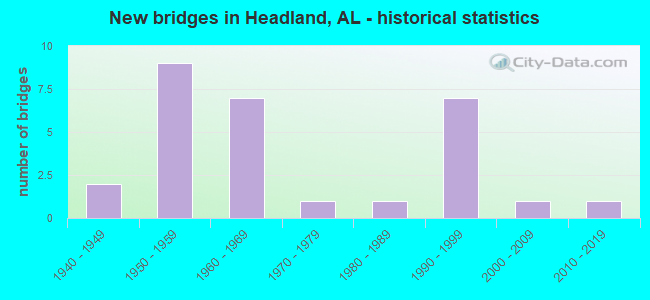
- New bridges - historical statistics
- 21940-1949
- 91950-1959
- 71960-1969
- 11970-1979
- 11980-1989
- 71990-1999
- 12000-2009
- 12010-2019


- Bridge Condition - Deck
- 16.7%Excellent
- 16.7%Very good
- 66.7%Good

- Bridge Condition - Superstructure
- 16.7%Excellent
- 16.7%Very good
- 50.0%Good
- 16.7%Satisfactory

- Bridge Condition - Substructure
- 16.7%Excellent
- 16.7%Very good
- 16.7%Good
- 33.3%Satisfactory
- 16.7%Fair

- Bridge Condition - Channel
- 24.1%Very good
- 41.4%Good
- 31.0%Satisfactory
- 3.4%Fair

- Bridge Condition - Culverts
- 26.1%Very good
- 26.1%Good
- 39.1%Satisfactory
- 8.7%Fair
Find on map >> Show street view
Structure Number: 2137, Location: CONC. BR. CULVT 431 BUS. (Lat: 31.328467, Lng: -85.351339), Route carried "on" structure: County highway , Year Built: 1940, Status: Open, Structure Length: 1.01m (3.31ft), Average Daily Traffic: 2,370 (year 2015), Truck Traffic: 6%, Average Future Daily Traffic: 3,000 (year 2035), Design Load: H 20, Features Intersected: JONES BRANCH, Facility Carried by Structure: ROAD
Minimum Vertical Clearance: 7.56m (24.80ft), Kilometerpoint: 0.010, Lanes on structure: 2, Owner: City or Municipal Highway Agency, Approaching Roadway Width: 9.1m (29.9ft), Material/Design: Concrete, Design/Construction: Culvert, Number Of Spans In Main Unit: 1, Length of Maximum Span: 10.1m (33.1ft), Curb-To-Curb Width: 9.1m (29.9ft), Out-to-Out Width: 10.1m (33.1ft)
Condition: Channel: Satisfactory, Culverts: Fair, Operating Rating: 32.7 metric tons, Method Used To Determine Operating Rating: Field evaluation and documented engineering judgment, Inventory Rating: 23.6 metric tons, Method Used To Determine Inventory Rating: Field evaluation and documented engineering judgment, Structural Evaluation: Somewhat better than minimum adequacy, Deck Geometry: Meets minimum limits, Waterway Adequacy: Better than present minimum criteria, Approach Roadway Alignment: Better than present minimum criteria, Length Of Structure Improvement: 1.68m (5.51ft), Designated Inspection Frequency: Every 24 months, Inspection Date: January 2021, Bridge Improvement Cost: $291,000, Roadway Improvement Cost: $29,000, Total Project Cost: $320,000 ( Estimate for 2022), Deck Structure Type: Concrete Cast-file-Place, Wearing Surface/Protective System: Wearing Surface: Bituminous
Find on map >> Show street view
Structure Number: 2317, Location: GEIGER (Lat: 32.863983, Lng: -88.304983), Route carried "on" structure: State highway 17, Year Built: 1940, Status: Open, Structure Length: 0.67m (2.20ft), Average Daily Traffic: 1,537 (year 2020), Truck Traffic: 22%, Average Future Daily Traffic: 2,519 (year 2040), Design Load: H 15, Features Intersected: UT CANEY CREEK
Minimum Vertical Clearance: 30+ m (98+ ft), Kilometerpoint: 267.805, Lanes on structure: 2, Owner: State Highway Agency, Approaching Roadway Width: 11.3m (37.1ft), Material/Design: Concrete, Design/Construction: Culvert, Number Of Spans In Main Unit: 2, Length of Maximum Span: 3.0m (9.8ft)
Condition: Channel: Satisfactory, Culverts: Satisfactory, Operating Rating: 66.6 metric tons, Method Used To Determine Operating Rating: Load Factor (LF), Inventory Rating: 39.9 metric tons, Method Used To Determine Inventory Rating: Load Factor (LF), Structural Evaluation: Equal to present minimum criteria, Waterway Adequacy: Equal to present minimum criteria, Approach Roadway Alignment: Equal to present desirable criteria, Length Of Structure Improvement: 1.30m (4.27ft), Designated Inspection Frequency: Every 24 months, Inspection Date: Febuary 2021, Bridge Improvement Cost: $503,000, Roadway Improvement Cost: $50,000, Total Project Cost: $553,000 ( Estimate for 2022)
Find on map >> Show street view
Structure Number: 5037, Location: 1.6 MI. NORTH OF HEADLAND (Lat: 31.385614, Lng: -85.285717), Route carried "on" structure: County highway 99, Year Built: 1955, Status: Open, Structure Length: 1.19m (3.90ft), Average Daily Traffic: 2,320 (year 2015), Truck Traffic: 10%, Average Future Daily Traffic: 2,600 (year 2035), Design Load: H 15, Features Intersected: SPIVEY MILL CREEK
Minimum Vertical Clearance: 30+ m (98+ ft), Kilometerpoint: 29.390, Lanes on structure: 2, Owner: County Highway Agency, Approaching Roadway Width: 13.7m (44.9ft), Material/Design: Concrete, Design/Construction: Culvert, Number Of Spans In Main Unit: 3, Length of Maximum Span: 3.7m (12.1ft)
Condition: Channel: Satisfactory, Culverts: Fair, Operating Rating: 88.9 metric tons, Method Used To Determine Operating Rating: Load Factor (LF), Inventory Rating: 88.9 metric tons, Method Used To Determine Inventory Rating: Load Factor (LF), Structural Evaluation: Somewhat better than minimum adequacy, Waterway Adequacy: Equal to present desirable criteria, Approach Roadway Alignment: Equal to present desirable criteria, Length Of Structure Improvement: 1.86m (6.10ft), Designated Inspection Frequency: Every 24 months, Inspection Date: January 2021, Bridge Improvement Cost: $1,333,000, Roadway Improvement Cost: $133,000, Total Project Cost: $1,466,000 ( Estimate for 2022)
Find on map >> Show street view
Structure Number: 5744, Location: BRIDGE ON FAS RT 07 (Lat: 31.380736, Lng: -85.397353), Route carried "on" structure: County highway 83, Year Built: 1957, Status: Posted for load, Structure Length: 5.18m (16.99ft), Average Daily Traffic: 600 (year 2014), Truck Traffic: 5%, Average Future Daily Traffic: 700 (year 2034), Design Load: H 15, Features Intersected: BLACKWOOD CREEK
Minimum Vertical Clearance: 30+ m (98+ ft), Kilometerpoint: 0.010, Lanes on structure: 2, Owner: County Highway Agency, Approaching Roadway Width: 7.3m (24.0ft), Material/Design: Concrete, Design/Construction: Tee Beam, Number Of Spans In Main Unit: 5, Length of Maximum Span: 10.4m (34.1ft), Curb-To-Curb Width: 6.6m (21.7ft), Out-to-Out Width: 7.1m (23.3ft)
Condition: Deck: Good, Superstructure: Satisfactory, Substructure: Fair, Channel: Satisfactory, Operating Rating: 43.3 metric tons, Method Used To Determine Operating Rating: Allowable Stress (AS), Inventory Rating: 26.8 metric tons, Method Used To Determine Inventory Rating: Allowable Stress (AS), Structural Evaluation: Somewhat better than minimum adequacy, Deck Geometry: High priority of corrective action, Waterway Adequacy: Better than present minimum criteria, Approach Roadway Alignment: Equal to present minimum criteria, Bridge Posting: Required (Relationship of Operating Rating to Maximum Legal Load: 0.1 - 9.9% below), Length Of Structure Improvement: 6.20m (20.34ft), Designated Inspection Frequency: Every 24 months, Underwater Inspection Frequency: Every 48 months, Other Special Inspection Frequency: Every 12 months, Inspection Date: November 2020, Underwater Inspection Date: December 2018, Other Special Inspection Date: December 2021, Bridge Improvement Cost: $978,000, Roadway Improvement Cost: $98,000, Total Project Cost: $1,076,000 ( Estimate for 2022), Deck Structure Type: Concrete Cast-file-Place
Find on map >> Show street view
Structure Number: 5863, Location: SEC-10 T-5-N R-26-E (Lat: 31.417858, Lng: -85.431953), Route carried "on" structure: County highway 16, Year Built: 1957, Status: Open, Structure Length: 0.99m (3.25ft), Average Daily Traffic: 256 (year 2002), Truck Traffic: 9%, Average Future Daily Traffic: 380 (year 2034), Design Load: H 15, Features Intersected: TURKEY CREEK
Minimum Vertical Clearance: 30+ m (98+ ft), Kilometerpoint: 0.000, Lanes on structure: 2, Owner: County Highway Agency, Approaching Roadway Width: 8.5m (27.9ft), Material/Design: Concrete, Design/Construction: Culvert, Number Of Spans In Main Unit: 3, Length of Maximum Span: 3.0m (9.8ft)
Condition: Channel: Good, Culverts: Good, Operating Rating: 41.0 metric tons, Method Used To Determine Operating Rating: Load Factor (LF), Inventory Rating: 24.6 metric tons, Method Used To Determine Inventory Rating: Load Factor (LF), Structural Evaluation: Equal to present minimum criteria, Waterway Adequacy: Better than present minimum criteria, Approach Roadway Alignment: Better than present minimum criteria, Length Of Structure Improvement: 1.66m (5.45ft), Designated Inspection Frequency: Every 24 months, Inspection Date: August 2020, Bridge Improvement Cost: $346,000, Roadway Improvement Cost: $35,000, Total Project Cost: $381,000 ( Estimate for 2022)
Find on map >> Show street view
Structure Number: 5986, Location: SEC-28 T-5-N R-26-E (Lat: 31.376494, Lng: -85.448233), Route carried "on" structure: County highway 73, Year Built: 1957, Status: Posted for load, Structure Length: 5.18m (16.99ft), Average Daily Traffic: 439 (year 2006), Truck Traffic: 7%, Average Future Daily Traffic: 652 (year 2034), Design Load: H 15, Features Intersected: BLACKWOOD CREEK
Minimum Vertical Clearance: 30+ m (98+ ft), Kilometerpoint: 0.000, Lanes on structure: 2, Owner: County Highway Agency, Approaching Roadway Width: 9.1m (29.9ft), Material/Design: Concrete, Design/Construction: Tee Beam, Number Of Spans In Main Unit: 5, Length of Maximum Span: 10.4m (34.1ft), Curb-To-Curb Width: 6.7m (22.0ft), Out-to-Out Width: 7.7m (25.3ft)
Condition: Deck: Good, Superstructure: Good, Substructure: Satisfactory, Channel: Satisfactory, Operating Rating: 35.7 metric tons, Method Used To Determine Operating Rating: Load Factor (LF), Inventory Rating: 21.4 metric tons, Method Used To Determine Inventory Rating: Load Factor (LF), Structural Evaluation: Equal to present minimum criteria, Deck Geometry: Meets minimum limits, Waterway Adequacy: Equal to present minimum criteria, Approach Roadway Alignment: Better than present minimum criteria, Bridge Posting: Required (Relationship of Operating Rating to Maximum Legal Load: 0.1 - 9.9% below), Length Of Structure Improvement: 6.20m (20.34ft), Designated Inspection Frequency: Every 24 months, Other Special Inspection Frequency: Every 12 months, Inspection Date: July 2021, Other Special Inspection Date: July 2021, Bridge Improvement Cost: $1,063,000, Roadway Improvement Cost: $106,000, Total Project Cost: $1,169,000 ( Estimate for 2022), Deck Structure Type: Concrete Cast-file-Place
Find on map >> Show street view
Structure Number: 6121, Location: RC BR. CULVT. WALDEN RD. (Lat: 31.338508, Lng: -85.314094), Route carried "on" structure: County highway , Year Built: 1958, Status: Open, Structure Length: 0.64m (2.10ft), Average Daily Traffic: 665 (year 2015), Truck Traffic: 2%, Average Future Daily Traffic: 715 (year 2035), Design Load: HS 15, Features Intersected: WALDEN BRANCH, Facility Carried by Structure: ROAD
Minimum Vertical Clearance: 7.56m (24.80ft), Kilometerpoint: 0.010, Lanes on structure: 2, Owner: County Highway Agency, Approaching Roadway Width: 7.3m (24.0ft), Material/Design: Concrete, Design/Construction: Culvert, Number Of Spans In Main Unit: 2, Length of Maximum Span: 3.0m (9.8ft)
Condition: Channel: Good, Culverts: Satisfactory, Operating Rating: 81.6 metric tons, Method Used To Determine Operating Rating: Load Factor (LF), Inventory Rating: 49.0 metric tons, Method Used To Determine Inventory Rating: Load Factor (LF), Structural Evaluation: Equal to present minimum criteria, Waterway Adequacy: Equal to present desirable criteria, Approach Roadway Alignment: Better than present minimum criteria, Length Of Structure Improvement: 1.26m (4.13ft), Designated Inspection Frequency: Every 24 months, Inspection Date: January 2021, Bridge Improvement Cost: $218,000, Roadway Improvement Cost: $22,000, Total Project Cost: $240,000 ( Estimate for 2022)
Find on map >> Show street view
Structure Number: 6122, Location: RC. BR. CULVT. ON CO. 13 (Lat: 31.322519, Lng: -85.301856), Route carried "on" structure: County highway , Year Built: 1958, Status: Open, Structure Length: 1.31m (4.30ft), Average Daily Traffic: 440 (year 2015), Truck Traffic: 1%, Average Future Daily Traffic: 475 (year 2035), Design Load: H 20, Features Intersected: LITTLE OMUSEE CREEK, Facility Carried by Structure: ROAD
Minimum Vertical Clearance: 30+ m (98+ ft), Kilometerpoint: 0.010, Lanes on structure: 2, Owner: County Highway Agency, Approaching Roadway Width: 7.3m (24.0ft), Material/Design: Concrete, Design/Construction: Culvert, Number Of Spans In Main Unit: 4, Length of Maximum Span: 3.0m (9.8ft)
Condition: Channel: Good, Culverts: Satisfactory, Operating Rating: 59.1 metric tons, Method Used To Determine Operating Rating: Load Factor (LF), Inventory Rating: 35.5 metric tons, Method Used To Determine Inventory Rating: Load Factor (LF), Structural Evaluation: Equal to present minimum criteria, Waterway Adequacy: Better than present minimum criteria, Approach Roadway Alignment: Better than present minimum criteria, Length Of Structure Improvement: 1.98m (6.50ft), Designated Inspection Frequency: Every 24 months, Inspection Date: January 2021, Bridge Improvement Cost: $344,000, Roadway Improvement Cost: $34,000, Total Project Cost: $378,000 ( Estimate for 2022), Deck Structure Type: Concrete Cast-file-Place
Find on map >> Show street view
Structure Number: 6123, Location: RC CULVT. ON PAVED RD. 8 (Lat: 31.371656, Lng: -85.251867), Route carried "on" structure: County highway , Year Built: 1959, Status: Open, Structure Length: 0.99m (3.25ft), Average Daily Traffic: 100 (year 2015), Truck Traffic: 2%, Average Future Daily Traffic: 120 (year 2035), Design Load: H 20, Features Intersected: DESHAZO BRANCH, Facility Carried by Structure: ROAD
Minimum Vertical Clearance: 7.56m (24.80ft), Kilometerpoint: 0.010, Lanes on structure: 2, Owner: County Highway Agency, Approaching Roadway Width: 7.3m (24.0ft), Material/Design: Concrete, Design/Construction: Culvert, Number Of Spans In Main Unit: 3, Length of Maximum Span: 3.0m (9.8ft)
Condition: Channel: Satisfactory, Culverts: Satisfactory, Operating Rating: 68.1 metric tons, Method Used To Determine Operating Rating: Load Factor (LF), Inventory Rating: 40.9 metric tons, Method Used To Determine Inventory Rating: Load Factor (LF), Structural Evaluation: Equal to present minimum criteria, Waterway Adequacy: Better than present minimum criteria, Approach Roadway Alignment: Better than present minimum criteria, Length Of Structure Improvement: 1.66m (5.45ft), Designated Inspection Frequency: Every 24 months, Inspection Date: January 2021, Bridge Improvement Cost: $346,000, Roadway Improvement Cost: $35,000, Total Project Cost: $381,000 ( Estimate for 2022)
Find on map >> Show street view
Structure Number: 6684, Location: SEC-10 T-5-N R-26-E (Lat: 31.418719, Lng: -85.427086), Route carried "on" structure: County highway 83, Year Built: 1959, Status: Posted for load, Structure Length: 11.40m (37.40ft), Average Daily Traffic: 552 (year 2000), Truck Traffic: 6%, Average Future Daily Traffic: 820 (year 2034), Design Load: HS 15, Features Intersected: EAST CHOCTAWHATCHEE R
Minimum Vertical Clearance: 30+ m (98+ ft), Kilometerpoint: 0.000, Lanes on structure: 2, Owner: County Highway Agency, Approaching Roadway Width: 8.5m (27.9ft), Material/Design: Concrete, Design/Construction: Tee Beam, Number Of Spans In Main Unit: 11, Length of Maximum Span: 10.4m (34.1ft), Curb-To-Curb Width: 6.7m (22.0ft), Out-to-Out Width: 7.7m (25.3ft)
Condition: Deck: Good, Superstructure: Good, Substructure: Satisfactory, Channel: Satisfactory, Operating Rating: 35.7 metric tons, Method Used To Determine Operating Rating: Load Factor (LF), Inventory Rating: 21.4 metric tons, Method Used To Determine Inventory Rating: Load Factor (LF), Structural Evaluation: Somewhat better than minimum adequacy, Deck Geometry: Meets minimum limits, Waterway Adequacy: Equal to present minimum criteria, Approach Roadway Alignment: Better than present minimum criteria, Bridge Posting: Required (Relationship of Operating Rating to Maximum Legal Load: 0.1 - 9.9% below), Length Of Structure Improvement: 12.27m (40.26ft), Designated Inspection Frequency: Every 24 months, Other Special Inspection Frequency: Every 12 months, Inspection Date: August 2020, Other Special Inspection Date: August 2021, Bridge Improvement Cost: $2,104,000, Roadway Improvement Cost: $210,000, Total Project Cost: $2,314,000 ( Estimate for 2022), Deck Structure Type: Concrete Cast-file-Place
Find on map >> Show street view
Structure Number: 6685, Location: SEC-10 T-5-N R-26-E (Lat: 31.418250, Lng: -85.426244), Route carried "on" structure: County highway 83, Year Built: 1959, Status: Posted for load, Structure Length: 4.15m (13.62ft), Average Daily Traffic: 552 (year 2000), Truck Traffic: 5%, Average Future Daily Traffic: 820 (year 2034), Design Load: HS 15, Features Intersected: EAST CHOCTAWHATCHEE R
Minimum Vertical Clearance: 30+ m (98+ ft), Kilometerpoint: 0.000, Lanes on structure: 2, Owner: County Highway Agency, Approaching Roadway Width: 8.5m (27.9ft), Material/Design: Concrete, Design/Construction: Tee Beam, Number Of Spans In Main Unit: 4, Length of Maximum Span: 10.4m (34.1ft), Curb-To-Curb Width: 6.7m (22.0ft), Out-to-Out Width: 7.7m (25.3ft)
Condition: Deck: Good, Superstructure: Good, Substructure: Good, Channel: Good, Operating Rating: 35.7 metric tons, Method Used To Determine Operating Rating: Load Factor (LF), Inventory Rating: 21.4 metric tons, Method Used To Determine Inventory Rating: Load Factor (LF), Structural Evaluation: Somewhat better than minimum adequacy, Deck Geometry: Meets minimum limits, Waterway Adequacy: Superior to present desirable criteria, Approach Roadway Alignment: Equal to present minimum criteria, Bridge Posting: Required (Relationship of Operating Rating to Maximum Legal Load: 0.1 - 9.9% below), Length Of Structure Improvement: 5.12m (16.80ft), Designated Inspection Frequency: Every 24 months, Other Special Inspection Frequency: Every 12 months, Inspection Date: August 2021, Other Special Inspection Date: August 2021, Bridge Improvement Cost: $877,000, Roadway Improvement Cost: $88,000, Total Project Cost: $965,000 ( Estimate for 2022), Deck Structure Type: Concrete Cast-file-Place
Find on map >> Show street view
Structure Number: 686, Location: RC.BR.CULVT. ON PAVRD. 70 (Lat: 31.419578, Lng: -85.273989), Route carried "on" structure: County highway , Year Built: 1960, Status: Open, Structure Length: 0.94m (3.08ft), Average Daily Traffic: 90 (year 2015), Truck Traffic: 2%, Average Future Daily Traffic: 110 (year 2035), Design Load: H 20, Features Intersected: SANDY CREEK BRANCH, Facility Carried by Structure: LOUIE SHELLEY ROA
Minimum Vertical Clearance: 30+ m (98+ ft), Kilometerpoint: 0.010, Lanes on structure: 2, Owner: County Highway Agency, Approaching Roadway Width: 7.3m (24.0ft), Material/Design: Concrete, Design/Construction: Culvert, Number Of Spans In Main Unit: 3, Length of Maximum Span: 3.0m (9.8ft)
Condition: Channel: Satisfactory, Culverts: Good, Operating Rating: 67.0 metric tons, Method Used To Determine Operating Rating: Load Factor (LF), Inventory Rating: 40.2 metric tons, Method Used To Determine Inventory Rating: Load Factor (LF), Structural Evaluation: Better than present minimum criteria, Waterway Adequacy: Better than present minimum criteria, Approach Roadway Alignment: Better than present minimum criteria, Length Of Structure Improvement: 1.61m (5.28ft), Designated Inspection Frequency: Every 24 months, Inspection Date: January 2021, Bridge Improvement Cost: $446,000, Roadway Improvement Cost: $45,000, Total Project Cost: $491,000 ( Estimate for 2022)
Find on map >> Show street view
Structure Number: 6861, Location: RC BR. CULVT.ON WOODS RD (Lat: 31.332078, Lng: -85.354414), Route carried "on" structure: County highway , Year Built: 1960, Status: Open, Structure Length: 0.98m (3.22ft), Average Daily Traffic: 320 (year 2015), Truck Traffic: 3%, Average Future Daily Traffic: 400 (year 2035), Design Load: H 20, Features Intersected: JONES BRANCH, Facility Carried by Structure: ROAD
Minimum Vertical Clearance: 30+ m (98+ ft), Kilometerpoint: 0.010, Lanes on structure: 2, Owner: City or Municipal Highway Agency, Approaching Roadway Width: 7.3m (24.0ft), Material/Design: Concrete, Design/Construction: Culvert, Number Of Spans In Main Unit: 2, Length of Maximum Span: 3.0m (9.8ft), Curb-To-Curb Width: 9.8m (32.2ft), Out-to-Out Width: 10.4m (34.1ft)
Condition: Channel: Fair, Culverts: Satisfactory, Operating Rating: 76.3 metric tons, Method Used To Determine Operating Rating: Load Factor (LF), Inventory Rating: 45.8 metric tons, Method Used To Determine Inventory Rating: Load Factor (LF), Structural Evaluation: Equal to present minimum criteria, Deck Geometry: Better than present minimum criteria, Waterway Adequacy: Better than present minimum criteria, Approach Roadway Alignment: Better than present minimum criteria, Length Of Structure Improvement: 1.65m (5.41ft), Designated Inspection Frequency: Every 24 months, Inspection Date: January 2021, Bridge Improvement Cost: $286,000, Roadway Improvement Cost: $29,000, Total Project Cost: $315,000 ( Estimate for 2022)
Find on map >> Show street view
Structure Number: 7581, Location: RC BR. CULVT. ON PA. 25 (Lat: 31.382053, Lng: -85.396217), Route carried "on" structure: County highway , Year Built: 1962, Status: Open, Structure Length: 0.79m (2.59ft), Average Daily Traffic: 120 (year 2015), Average Future Daily Traffic: 150 (year 2035), Design Load: H 10, Features Intersected: HICKS BRANCH, Facility Carried by Structure: ROAD
Minimum Vertical Clearance: 30+ m (98+ ft), Kilometerpoint: 0.010, Lanes on structure: 2, Owner: County Highway Agency, Approaching Roadway Width: 7.3m (24.0ft), Material/Design: Concrete, Design/Construction: Culvert, Number Of Spans In Main Unit: 2, Length of Maximum Span: 3.7m (12.1ft)
Condition: Channel: Good, Culverts: Good, Operating Rating: 42.8 metric tons, Method Used To Determine Operating Rating: Load Factor (LF), Inventory Rating: 18.1 metric tons, Method Used To Determine Inventory Rating: Load Factor (LF), Structural Evaluation: Somewhat better than minimum adequacy, Waterway Adequacy: Equal to present minimum criteria, Approach Roadway Alignment: Somewhat better than minimum adequacy, Length Of Structure Improvement: 1.44m (4.72ft), Designated Inspection Frequency: Every 24 months, Inspection Date: December 2020, Bridge Improvement Cost: $317,000, Roadway Improvement Cost: $32,000, Total Project Cost: $349,000 ( Estimate for 2022)
Find on map >> Show street view
Structure Number: 7879, Location: BR. CULVT. ON CO. RD. 15 (Lat: 31.319742, Lng: -85.279811), Route carried "on" structure: County highway , Year Built: 1963, Status: Open, Structure Length: 0.79m (2.59ft), Average Daily Traffic: 350 (year 2015), Truck Traffic: 2%, Average Future Daily Traffic: 400 (year 2035), Design Load: H 20, Features Intersected: GIVENS BRANCH, Facility Carried by Structure: ROAD
Minimum Vertical Clearance: 7.56m (24.80ft), Kilometerpoint: 0.010, Lanes on structure: 2, Owner: County Highway Agency, Approaching Roadway Width: 7.3m (24.0ft), Material/Design: Concrete, Design/Construction: Culvert, Number Of Spans In Main Unit: 3, Length of Maximum Span: 2.4m (7.9ft)
Condition: Channel: Good, Culverts: Satisfactory, Operating Rating: 34.2 metric tons, Method Used To Determine Operating Rating: Load Factor (LF), Inventory Rating: 20.5 metric tons, Method Used To Determine Inventory Rating: Load Factor (LF), Structural Evaluation: Somewhat better than minimum adequacy, Waterway Adequacy: Better than present minimum criteria, Approach Roadway Alignment: Better than present minimum criteria, Length Of Structure Improvement: 1.44m (4.72ft), Designated Inspection Frequency: Every 24 months, Inspection Date: January 2021, Bridge Improvement Cost: $250,000, Roadway Improvement Cost: $25,000, Total Project Cost: $275,000 ( Estimate for 2022)
Find on map >> Show street view
Structure Number: 8632, Location: RC BR. CULVT. ON CORD. 5 (Lat: 31.376097, Lng: -85.355828), Route carried "on" structure: County highway , Year Built: 1965, Status: Open, Structure Length: 2.29m (7.51ft), Average Daily Traffic: 120 (year 2015), Average Future Daily Traffic: 150 (year 2035), Design Load: H 20, Features Intersected: MCCLENNY MILL CREEK, Facility Carried by Structure: ROAD
Minimum Vertical Clearance: 30+ m (98+ ft), Kilometerpoint: 0.010, Lanes on structure: 2, Owner: County Highway Agency, Approaching Roadway Width: 7.3m (24.0ft), Material/Design: Concrete, Design/Construction: Culvert, Number Of Spans In Main Unit: 7, Length of Maximum Span: 3.0m (9.8ft)
Condition: Channel: Good, Culverts: Satisfactory, Operating Rating: 40.3 metric tons, Method Used To Determine Operating Rating: Load Factor (LF), Inventory Rating: 24.1 metric tons, Method Used To Determine Inventory Rating: Load Factor (LF), Structural Evaluation: Equal to present minimum criteria, Waterway Adequacy: Better than present minimum criteria, Approach Roadway Alignment: Equal to present minimum criteria, Length Of Structure Improvement: 3.12m (10.24ft), Designated Inspection Frequency: Every 24 months, Inspection Date: January 2021, Bridge Improvement Cost: $846,000, Roadway Improvement Cost: $85,000, Total Project Cost: $931,000 ( Estimate for 2022)
Find on map >> Show street view
Structure Number: 8633, Location: BR. CULVT. ON PAVEDRD. 33 (Lat: 31.383894, Lng: -85.336378), Route carried "on" structure: County highway , Year Built: 1965, Status: Open, Structure Length: 1.10m (3.61ft), Average Daily Traffic: 330 (year 2015), Truck Traffic: 2%, Average Future Daily Traffic: 360 (year 2035), Design Load: H 15, Features Intersected: GIVENS BRANCH, Facility Carried by Structure: ROAD
Minimum Vertical Clearance: 30+ m (98+ ft), Kilometerpoint: 0.010, Lanes on structure: 2, Owner: County Highway Agency, Approaching Roadway Width: 7.3m (24.0ft), Skew: 4 degrees, Material/Design: Concrete, Design/Construction: Culvert, Number Of Spans In Main Unit: 2, Length of Maximum Span: 4.9m (16.1ft)
Condition: Channel: Good, Culverts: Good, Operating Rating: 50.1 metric tons, Method Used To Determine Operating Rating: Load Factor (LF), Inventory Rating: 30.0 metric tons, Method Used To Determine Inventory Rating: Load Factor (LF), Structural Evaluation: Better than present minimum criteria, Waterway Adequacy: Better than present minimum criteria, Approach Roadway Alignment: Equal to present desirable criteria, Length Of Structure Improvement: 1.77m (5.81ft), Designated Inspection Frequency: Every 24 months, Inspection Date: January 2021, Bridge Improvement Cost: $574,000, Roadway Improvement Cost: $57,000, Total Project Cost: $631,000 ( Estimate for 2022)
Find on map >> Show street view
Structure Number: 9034, Location: 1 MI. N. HOUSTON CO. L. (Lat: 31.326433, Lng: -85.341567), Route carried "on" structure: US 431, Year Built: 1966, Status: Open, Structure Length: 0.96m (3.15ft), Average Daily Traffic: 16,050 (year 2013), Truck Traffic: 9%, Average Future Daily Traffic: 20,781 (year 2033), Design Load: H 20, Features Intersected: SPIVEY CREEK
Minimum Vertical Clearance: 30+ m (98+ ft), Kilometerpoint: 38.006, Lanes on structure: 4, Base Highway Network: Yes, Owner: State Highway Agency, Approaching Roadway Width: 24.4m (80.1ft), Skew: 20 degrees, Material/Design: Concrete, Design/Construction: Culvert, Number Of Spans In Main Unit: 3, Length of Maximum Span: 3.0m (9.8ft)
Condition: Channel: Good, Culverts: Satisfactory, Operating Rating: 88.9 metric tons, Method Used To Determine Operating Rating: Load Factor (LF), Inventory Rating: 88.9 metric tons, Method Used To Determine Inventory Rating: Load Factor (LF), Structural Evaluation: Equal to present minimum criteria, Waterway Adequacy: Equal to present desirable criteria, Approach Roadway Alignment: Equal to present desirable criteria, Length Of Structure Improvement: 1.63m (5.35ft), Designated Inspection Frequency: Every 24 months, Inspection Date: July 2021, Bridge Improvement Cost: $1,733,000, Roadway Improvement Cost: $173,000, Total Project Cost: $1,906,000 ( Estimate for 2022)
Find on map >> Show street view
Structure Number: 1072, Location: BR. CULVT. ON PAVEDRD. 6 (Lat: 31.331856, Lng: -85.272211), Route carried "on" structure: County highway , Year Built: 1972, Status: Open, Structure Length: 0.76m (2.49ft), Average Daily Traffic: 90 (year 2014), Average Future Daily Traffic: 120 (year 2034), Design Load: H 20, Features Intersected: DOUGLAS BRANCH, Facility Carried by Structure: ROAD
Minimum Vertical Clearance: 7.56m (24.80ft), Kilometerpoint: 0.010, Lanes on structure: 2, Owner: County Highway Agency, Approaching Roadway Width: 7.3m (24.0ft), Skew: 3 degrees, Material/Design: Concrete, Design/Construction: Culvert, Number Of Spans In Main Unit: 2, Length of Maximum Span: 3.7m (12.1ft)
Condition: Channel: Very good, Culverts: Satisfactory, Operating Rating: 61.7 metric tons, Method Used To Determine Operating Rating: Load Factor (LF), Inventory Rating: 37.0 metric tons, Method Used To Determine Inventory Rating: Load Factor (LF), Structural Evaluation: Equal to present minimum criteria, Waterway Adequacy: Better than present minimum criteria, Approach Roadway Alignment: Equal to present minimum criteria, Length Of Structure Improvement: 1.41m (4.63ft), Designated Inspection Frequency: Every 24 months, Inspection Date: December 2020, Bridge Improvement Cost: $504,000, Roadway Improvement Cost: $50,000, Total Project Cost: $554,000 ( Estimate for 2022)
Find on map >> Show street view
Structure Number: 13215, Location: 1 MI. N. JCT. SR 173 (Lat: 31.378017, Lng: -85.327000), Route carried "on" structure: US 431, Year Built: 1984, Status: Open, Structure Length: 1.62m (5.31ft), Average Daily Traffic: 12,210 (year 2013), Truck Traffic: 10%, Average Future Daily Traffic: 15,809 (year 2033), Design Load: HS 20, Features Intersected: STREAM
Minimum Vertical Clearance: 30+ m (98+ ft), Kilometerpoint: 44.143, Lanes on structure: 4, Base Highway Network: Yes, Owner: State Highway Agency, Approaching Roadway Width: 24.4m (80.1ft), Skew: 1 degrees, Material/Design: Concrete, Design/Construction: Culvert, Number Of Spans In Main Unit: 4, Length of Maximum Span: 3.8m (12.5ft)
Condition: Channel: Satisfactory, Culverts: Good, Operating Rating: 88.9 metric tons, Method Used To Determine Operating Rating: Load Factor (LF), Inventory Rating: 88.9 metric tons, Method Used To Determine Inventory Rating: Load Factor (LF), Structural Evaluation: Better than present minimum criteria, Waterway Adequacy: Equal to present desirable criteria, Approach Roadway Alignment: Equal to present desirable criteria, Length Of Structure Improvement: 2.30m (7.55ft), Designated Inspection Frequency: Every 24 months, Inspection Date: July 2021, Bridge Improvement Cost: $2,935,000, Roadway Improvement Cost: $294,000, Total Project Cost: $3,229,000 ( Estimate for 2022)
Find on map >> Show street view
Structure Number: 16274, Location: SEC. 34, T5N, R26E (Lat: 31.362508, Lng: -85.417294), Route carried "on" structure: County highway 79, Year Built: 1995, Status: Open, Structure Length: 2.07m (6.79ft), Average Daily Traffic: 442 (year 2002), Truck Traffic: 3%, Average Future Daily Traffic: 657 (year 2034), Design Load: H 20, Features Intersected: BLACKWOOD CREEK, Facility Carried by Structure: CO. RD. 14
Minimum Vertical Clearance: 30+ m (98+ ft), Kilometerpoint: 0.000, Lanes on structure: 2, Owner: County Highway Agency, Approaching Roadway Width: 9.1m (29.9ft), Material/Design: Concrete, Design/Construction: Culvert, Number Of Spans In Main Unit: 4, Length of Maximum Span: 4.9m (16.1ft)
Condition: Channel: Good, Culverts: Good, Operating Rating: 88.9 metric tons, Method Used To Determine Operating Rating: Load Factor (LF), Inventory Rating: 64.1 metric tons, Method Used To Determine Inventory Rating: Load Factor (LF), Structural Evaluation: Better than present minimum criteria, Waterway Adequacy: Equal to present minimum criteria, Approach Roadway Alignment: Better than present minimum criteria, Length Of Structure Improvement: 2.84m (9.32ft), Designated Inspection Frequency: Every 24 months, Inspection Date: March 2021, Bridge Improvement Cost: $836,000, Roadway Improvement Cost: $84,000, Total Project Cost: $920,000 ( Estimate for 2022)
Find on map >> Show street view
Structure Number: 16301, Location: 3MI W OF NEWVILLE (Lat: 31.416731, Lng: -85.400919), Route carried "on" structure: County highway , Year Built: 1995, Status: Open, Structure Length: 1.13m (3.71ft), Average Daily Traffic: 190 (year 2015), Truck Traffic: 5%, Average Future Daily Traffic: 230 (year 2035), Design Load: H 20, Features Intersected: CAMP BRANCH, Facility Carried by Structure: CO RD NO 14
Minimum Vertical Clearance: 30+ m (98+ ft), Kilometerpoint: 0.014, Lanes on structure: 2, Owner: County Highway Agency, Approaching Roadway Width: 8.5m (27.9ft), Material/Design: Concrete, Design/Construction: Culvert, Number Of Spans In Main Unit: 3, Length of Maximum Span: 3.7m (12.1ft)
Condition: Channel: Very good, Culverts: Very good, Operating Rating: 58.3 metric tons, Method Used To Determine Operating Rating: Load Factor (LF), Inventory Rating: 35.0 metric tons, Method Used To Determine Inventory Rating: Load Factor (LF), Structural Evaluation: Equal to present desirable criteria, Waterway Adequacy: Better than present minimum criteria, Approach Roadway Alignment: Equal to present desirable criteria, Length Of Structure Improvement: 1.81m (5.94ft), Designated Inspection Frequency: Every 24 months, Inspection Date: January 2021, Bridge Improvement Cost: $469,000, Roadway Improvement Cost: $47,000, Total Project Cost: $516,000 ( Estimate for 2022)
Find on map >> Show street view
Structure Number: 16592, Location: CO RD 49 (Lat: 31.367258, Lng: -85.263597), Route carried "on" structure: County highway , Year Built: 1995, Status: Open, Structure Length: 2.07m (6.79ft), Average Daily Traffic: 160 (year 2015), Truck Traffic: 2%, Average Future Daily Traffic: 200 (year 2035), Design Load: H 20, Features Intersected: SPIVEY MILL CREEK, Facility Carried by Structure: ROAD
Minimum Vertical Clearance: 7.56m (24.80ft), Kilometerpoint: 0.014, Lanes on structure: 2, Owner: County Highway Agency, Approaching Roadway Width: 9.1m (29.9ft), Material/Design: Concrete, Design/Construction: Culvert, Number Of Spans In Main Unit: 4, Length of Maximum Span: 4.6m (15.1ft)
Condition: Channel: Good, Culverts: Very good, Operating Rating: 81.5 metric tons, Method Used To Determine Operating Rating: Load Factor (LF), Inventory Rating: 48.9 metric tons, Method Used To Determine Inventory Rating: Load Factor (LF), Structural Evaluation: Equal to present desirable criteria, Waterway Adequacy: Better than present minimum criteria, Approach Roadway Alignment: Equal to present desirable criteria, Length Of Structure Improvement: 2.84m (9.32ft), Designated Inspection Frequency: Every 24 months, Inspection Date: January 2021, Bridge Improvement Cost: $655,000, Roadway Improvement Cost: $66,000, Total Project Cost: $721,000 ( Estimate for 2022)
Find on map >> Show street view
Structure Number: 16797, Location: HCP 34-05-94 (Lat: 31.395064, Lng: -85.303228), Route carried "on" structure: County highway , Year Built: 1997, Status: Open, Structure Length: 0.67m (2.20ft), Average Daily Traffic: 425 (year 2015), Truck Traffic: 10%, Average Future Daily Traffic: 550 (year 2035), Design Load: H 15, Features Intersected: SPIVEY MILL CREEK, Facility Carried by Structure: CO RO 45
Minimum Vertical Clearance: 30+ m (98+ ft), Kilometerpoint: 0.010, Lanes on structure: 2, Owner: County Highway Agency, Approaching Roadway Width: 8.5m (27.9ft), Material/Design: Concrete, Design/Construction: Culvert, Number Of Spans In Main Unit: 2, Length of Maximum Span: 3.0m (9.8ft)
Condition: Channel: Very good, Culverts: Very good, Operating Rating: 88.9 metric tons, Method Used To Determine Operating Rating: Load Factor (LF), Inventory Rating: 88.9 metric tons, Method Used To Determine Inventory Rating: Load Factor (LF), Structural Evaluation: Equal to present desirable criteria, Waterway Adequacy: Equal to present minimum criteria, Approach Roadway Alignment: Equal to present desirable criteria, Length Of Structure Improvement: 1.30m (4.27ft), Designated Inspection Frequency: Every 24 months, Inspection Date: January 2021, Bridge Improvement Cost: $405,000, Roadway Improvement Cost: $41,000, Total Project Cost: $446,000 ( Estimate for 2022)
Find on map >> Show street view
Structure Number: 16798, Location: HCP 34-09-94 (Lat: 31.387056, Lng: -85.370297), Route carried "on" structure: County highway , Year Built: 1997, Status: Open, Structure Length: 1.16m (3.81ft), Average Daily Traffic: 177 (year 2015), Truck Traffic: 2%, Average Future Daily Traffic: 200 (year 2035), Design Load: HS 20, Features Intersected: LITTLE BLACKWOOD CREEK, Facility Carried by Structure: CO RD 17
Minimum Vertical Clearance: 30+ m (98+ ft), Kilometerpoint: 0.010, Lanes on structure: 2, Owner: County Highway Agency, Approaching Roadway Width: 8.5m (27.9ft), Material/Design: Concrete, Design/Construction: Culvert, Number Of Spans In Main Unit: 3, Length of Maximum Span: 3.7m (12.1ft)
Condition: Channel: Very good, Culverts: Very good, Operating Rating: 79.6 metric tons, Method Used To Determine Operating Rating: Load Factor (LF), Inventory Rating: 47.7 metric tons, Method Used To Determine Inventory Rating: Load Factor (LF), Structural Evaluation: Equal to present desirable criteria, Waterway Adequacy: Better than present minimum criteria, Approach Roadway Alignment: Better than present minimum criteria, Length Of Structure Improvement: 1.84m (6.04ft), Designated Inspection Frequency: Every 24 months, Inspection Date: January 2021, Bridge Improvement Cost: $530,000, Roadway Improvement Cost: $53,000, Total Project Cost: $583,000 ( Estimate for 2022)
Find on map >> Show street view
Structure Number: 16799, Location: HCP 34-07-94 (Lat: 31.378892, Lng: -85.333433), Route carried "on" structure: County highway , Year Built: 1996, Status: Open, Structure Length: 1.17m (3.84ft), Average Daily Traffic: 405 (year 2015), Truck Traffic: 2%, Average Future Daily Traffic: 450 (year 2035), Design Load: HS 15, Features Intersected: GIVENS BRANCH, Facility Carried by Structure: CO RD 9 ROCK CRK
Minimum Vertical Clearance: 30+ m (98+ ft), Kilometerpoint: 0.010, Lanes on structure: 2, Owner: County Highway Agency, Approaching Roadway Width: 8.5m (27.9ft), Material/Design: Concrete, Design/Construction: Culvert, Number Of Spans In Main Unit: 3, Length of Maximum Span: 3.7m (12.1ft)
Condition: Channel: Very good, Culverts: Very good, Operating Rating: 75.9 metric tons, Method Used To Determine Operating Rating: Load Factor (LF), Inventory Rating: 45.5 metric tons, Method Used To Determine Inventory Rating: Load Factor (LF), Structural Evaluation: Equal to present desirable criteria, Waterway Adequacy: Better than present minimum criteria, Approach Roadway Alignment: Better than present minimum criteria, Length Of Structure Improvement: 1.84m (6.04ft), Designated Inspection Frequency: Every 24 months, Inspection Date: January 2021, Bridge Improvement Cost: $511,000, Roadway Improvement Cost: $51,000, Total Project Cost: $562,000 ( Estimate for 2022)
Find on map >> Show street view
Structure Number: 16802, Location: HCP 34-04-94 (Lat: 31.315378, Lng: -85.325275), Route carried "on" structure: County highway , Year Built: 1996, Status: Open, Structure Length: 1.19m (3.90ft), Average Daily Traffic: 500 (year 2015), Truck Traffic: 1%, Average Future Daily Traffic: 550 (year 2035), Design Load: HS 15, Features Intersected: WHITE BRANCH, Facility Carried by Structure: CO RD 11 WHITE RD
Minimum Vertical Clearance: 30+ m (98+ ft), Kilometerpoint: 0.010, Lanes on structure: 2, Owner: County Highway Agency, Approaching Roadway Width: 8.5m (27.9ft), Material/Design: Concrete, Design/Construction: Culvert, Number Of Spans In Main Unit: 3, Length of Maximum Span: 3.7m (12.1ft)
Condition: Channel: Good, Culverts: Very good, Operating Rating: 70.9 metric tons, Method Used To Determine Operating Rating: Load Factor (LF), Inventory Rating: 42.5 metric tons, Method Used To Determine Inventory Rating: Load Factor (LF), Structural Evaluation: Equal to present desirable criteria, Waterway Adequacy: Better than present minimum criteria, Approach Roadway Alignment: Better than present minimum criteria, Length Of Structure Improvement: 1.86m (6.10ft), Designated Inspection Frequency: Every 24 months, Inspection Date: January 2021, Bridge Improvement Cost: $538,000, Roadway Improvement Cost: $54,000, Total Project Cost: $592,000 ( Estimate for 2022)
Find on map >> Show street view
Structure Number: 17777, Location: 4.5 MI.E. OF HEADLAND (Lat: 31.350583, Lng: -85.249500), Route carried "on" structure: State highway 134, Year Built: 2002, Status: Open, Structure Length: 6.40m (21.00ft), Average Daily Traffic: 1,350 (year 2013), Truck Traffic: 12%, Average Future Daily Traffic: 1,944 (year 2033), Design Load: HS 20, Features Intersected: SPIVEY MILL CK.
Minimum Vertical Clearance: 30+ m (98+ ft), Kilometerpoint: 107.733, Lanes on structure: 2, Owner: State Highway Agency, Approaching Roadway Width: 12.2m (40.0ft), Material/Design: Prestressed concrete, Design/Construction: Stringer/Multi-beam, Number Of Spans In Main Unit: 3, Length of Maximum Span: 21.3m (69.9ft), Curb-To-Curb Width: 12.2m (40.0ft), Out-to-Out Width: 13.0m (42.7ft)
Condition: Deck: Very good, Superstructure: Very good, Substructure: Very good, Channel: Very good, Operating Rating: 69.7 metric tons, Method Used To Determine Operating Rating: Load Factor (LF), Inventory Rating: 46.5 metric tons, Method Used To Determine Inventory Rating: Load Factor (LF), Structural Evaluation: Equal to present desirable criteria, Deck Geometry: Better than present minimum criteria, Waterway Adequacy: Equal to present desirable criteria, Approach Roadway Alignment: Equal to present desirable criteria, Length Of Structure Improvement: 7.44m (24.41ft), Designated Inspection Frequency: Every 24 months, Inspection Date: May 2021, Bridge Improvement Cost: $2,143,000, Roadway Improvement Cost: $214,000, Total Project Cost: $2,357,000 ( Estimate for 2022), Deck Structure Type: Concrete Cast-file-Place
Find on map >> Show street view
Structure Number: 2022, Location: 1 m. n. henry co. 16 (Lat: 31.377083, Lng: -85.364900), Route carried "on" structure: State highway 173, Year Built: 2018, Status: Open, Structure Length: 8.99m (29.49ft), Average Daily Traffic: 680 (year 2013), Truck Traffic: 7%, Average Future Daily Traffic: 848 (year 2033), Design Load: HL 93, Features Intersected: BLACKWOOD CREEK
Minimum Vertical Clearance: 30+ m (98+ ft), Kilometerpoint: 5.423, Lanes on structure: 2, Owner: State Highway Agency, Approaching Roadway Width: 13.4m (44.0ft), Material/Design: Prestressed concrete, Design/Construction: Stringer/Multi-beam, Number Of Spans In Main Unit: 1, Number Of Approach Spans: 2, Length of Maximum Span: 41.1m (134.8ft), Curb-To-Curb Width: 13.4m (44.0ft), Out-to-Out Width: 14.2m (46.6ft)
Condition: Deck: Excellent, Superstructure: Excellent, Substructure: Excellent, Channel: Very good, Operating Rating: 88.9 metric tons, Method Used To Determine Operating Rating: Load Factor (LF), Inventory Rating: 38.4 metric tons, Method Used To Determine Inventory Rating: Load Factor (LF), Structural Evaluation: Superior to present desirable criteria, Deck Geometry: High priority of replacement, Waterway Adequacy: Equal to present desirable criteria, Approach Roadway Alignment: Equal to present desirable criteria, Length Of Structure Improvement: 9.96m (32.68ft), Designated Inspection Frequency: Every 24 months, Inspection Date: January 2021, Bridge Improvement Cost: $3,142,000, Roadway Improvement Cost: $314,000, Total Project Cost: $3,456,000 ( Estimate for 2022), Deck Structure Type: Concrete Cast-file-Place