Bridge Statistics for Hebron, New York (NY)
Condition, Traffic, Stress, Structural Evaluation, Project Costs
- National Bridge Inventory (NBI) Statistics
- 11Number of bridges
- 39ft / 11.9mTotal length
- $4,252,000Total costs
- 2,468Total average daily traffic
- 145Total average daily truck traffic
- 3,454Total future (year 2034) average daily traffic
- National Bridge Inventory (NBI) Registered Bridges for Hebron
- No street view available for this location
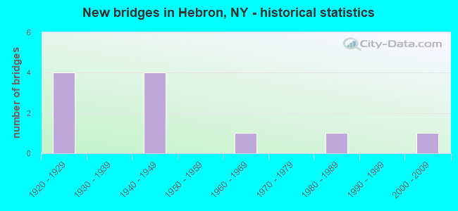
- New bridges - historical statistics
- 41920-1929
- 41940-1949
- 11960-1969
- 11980-1989
- 12000-2009

- Reconstructed bridges - Historical Statistics
- 21980-1989
- 51990-1999
- 12000-2009

- Bridge Condition - Deck
- 28.6%Very good
- 14.3%Good
- 57.1%Satisfactory

- Bridge Condition - Superstructure
- 14.3%Excellent
- 42.9%Very good
- 28.6%Good
- 14.3%Fair

- Bridge Condition - Substructure
- 14.3%Very good
- 28.6%Good
- 57.1%Fair

- Bridge Condition - Channel
- 9.1%Good
- 45.5%Satisfactory
- 36.4%Fair
- 9.1%Poor

- Bridge Condition - Culverts
- 25.0%Good
- 50.0%Satisfactory
- 25.0%Fair
Find on map >> Show street view
Structure Number: 22697, Location: 12M N VIL/SALEM OFF RT 22 (Lat: 43.313717, Lng: -73.273108), Route carried "on" structure: Other road , Year Built: 2001, Status: Open, Structure Length: 0.76m (2.49ft), Average Daily Traffic: 61 (year 2018), Truck Traffic: 6%, Average Future Daily Traffic: 85 (year 2038), Features Intersected: BLACK CREEK, Facility Carried by Structure: N GRIMES HILL RD
Minimum Vertical Clearance: 30+ m (98+ ft), Kilometerpoint: 2.108, Lanes on structure: 2, Owner: County Highway Agency, Approaching Roadway Width: 6.4m (21.0ft), Material/Design: Steel, Design/Construction: Culvert, Number Of Spans In Main Unit: 2, Length of Maximum Span: 3.3m (10.8ft)
Condition: Channel: Poor, Culverts: Satisfactory, Operating Rating: 73.9 metric tons, Method Used To Determine Operating Rating: Field evaluation and documented engineering judgment, Inventory Rating: 24.5 metric tons, Method Used To Determine Inventory Rating: Field evaluation and documented engineering judgment, Structural Evaluation: Equal to present minimum criteria, Waterway Adequacy: Meets minimum limits, Approach Roadway Alignment: Equal to present desirable criteria, Length Of Structure Improvement: 0.76m (2.49ft), Designated Inspection Frequency: Every 24 months, Inspection Date: June 2021, Bridge Improvement Cost: $86,000, Roadway Improvement Cost: $50,000, Total Project Cost: $136,000 ( Estimate for 2021)
Find on map >> Show street view
Structure Number: 330577, Location: 5 MILES NNW OF SALEM (Lat: 43.228083, Lng: -73.374547), Route carried "on" structure: County highway , Year Built: 1928, Year Reconstructed: 2001, Status: Open, Structure Length: 1.07m (3.51ft), Average Daily Traffic: 1,017 (year 2020), Truck Traffic: 5%, Average Future Daily Traffic: 1,424 (year 2040), Design Load: HS 25 or greater, Features Intersected: BLACK CREEK, Facility Carried by Structure: COUNTY ROAD 30
Minimum Vertical Clearance: 30+ m (98+ ft), Kilometerpoint: 10.153, Lanes on structure: 2, Owner: County Highway Agency, Approaching Roadway Width: 10.4m (34.1ft), Material/Design: Steel, Design/Construction: Stringer/Multi-beam, Number Of Spans In Main Unit: 1, Length of Maximum Span: 9.1m (29.9ft), Curb-To-Curb Width: 10.4m (34.1ft), Out-to-Out Width: 11.0m (36.1ft)
Condition: Deck: Satisfactory, Superstructure: Very good, Substructure: Fair, Channel: Satisfactory, Structural Evaluation: Somewhat better than minimum adequacy, Deck Geometry: Equal to present minimum criteria, Waterway Adequacy: Superior to present desirable criteria, Approach Roadway Alignment: Equal to present minimum criteria, Length Of Structure Improvement: 1.06m (3.48ft), Designated Inspection Frequency: Every 24 months, Inspection Date: August 2021, Bridge Improvement Cost: $557,000, Roadway Improvement Cost: $326,000, Total Project Cost: $883,000 ( Estimate for 2021), Deck Structure Type: Concrete Cast-file-Place, Wearing Surface/Protective System: Wearing Surface: Integral Concrete, Deck Protection: Epoxy Coated Reinforcing
Find on map >> Show street view
Structure Number: 330578, Location: 1 MI E OF WEST HEBRON (Lat: 43.232397, Lng: -73.355728), Route carried "on" structure: Other road , Year Built: 1928, Year Reconstructed: 2004, Status: Open, Structure Length: 1.40m (4.59ft), Average Daily Traffic: 281 (year 2019), Truck Traffic: 11%, Average Future Daily Traffic: 393 (year 2039), Design Load: H 20, Features Intersected: BLACK CREEK, Facility Carried by Structure: CHAMBERLAIN MILLS
Minimum Vertical Clearance: 30+ m (98+ ft), Kilometerpoint: 1.818, Lanes on structure: 2, Owner: County Highway Agency, Approaching Roadway Width: 5.8m (19.0ft), Material/Design: Steel, Design/Construction: Stringer/Multi-beam, Number Of Spans In Main Unit: 1, Length of Maximum Span: 12.5m (41.0ft), Curb-To-Curb Width: 7.4m (24.3ft), Out-to-Out Width: 8.3m (27.2ft)
Condition: Deck: Very good, Superstructure: Excellent, Substructure: Good, Channel: Satisfactory, Structural Evaluation: Better than present minimum criteria, Deck Geometry: Somewhat better than minimum adequacy, Waterway Adequacy: Meets minimum limits, Approach Roadway Alignment: Meets minimum limits, Length Of Structure Improvement: 1.40m (4.59ft), Designated Inspection Frequency: Every 24 months, Inspection Date: May 2020, Bridge Improvement Cost: $347,000, Roadway Improvement Cost: $203,000, Total Project Cost: $551,000 ( Estimate for 2021), Deck Structure Type: Concrete Cast-file-Place, Wearing Surface/Protective System: Wearing Surface: Integral Concrete
Find on map >> Show street view
Structure Number: 330579, Location: 0.1 MI SWS WEST PAWLET (Lat: 43.352367, Lng: -73.253650), Route carried "on" structure: County highway , Year Built: 1928, Year Reconstructed: 1994, Status: Open, Structure Length: 1.28m (4.20ft), Average Daily Traffic: 221 (year 2020), Truck Traffic: 6%, Average Future Daily Traffic: 309 (year 2040), Design Load: HS 20, Features Intersected: INDIAN RIVER, Facility Carried by Structure: PAWLET RD CR31
Minimum Vertical Clearance: 30+ m (98+ ft), Kilometerpoint: 18.117, Lanes on structure: 2, Owner: County Highway Agency, Approaching Roadway Width: 7.3m (24.0ft), Skew: 3 degrees, Material/Design: Steel, Design/Construction: Stringer/Multi-beam, Number Of Spans In Main Unit: 1, Length of Maximum Span: 12.4m (40.7ft), Curb-To-Curb Width: 7.3m (24.0ft), Out-to-Out Width: 8.0m (26.2ft)
Condition: Deck: Satisfactory, Superstructure: Fair, Substructure: Fair, Channel: Satisfactory, Operating Rating: 88.0 metric tons, Method Used To Determine Operating Rating: Load Factor (LF), Inventory Rating: 52.6 metric tons, Method Used To Determine Inventory Rating: Load Factor (LF), Structural Evaluation: Somewhat better than minimum adequacy, Deck Geometry: Somewhat better than minimum adequacy, Waterway Adequacy: Superior to present desirable criteria, Approach Roadway Alignment: Somewhat better than minimum adequacy, Length Of Structure Improvement: 1.28m (4.20ft), Designated Inspection Frequency: Every 24 months, Inspection Date: April 2020, Bridge Improvement Cost: $345,000, Roadway Improvement Cost: $202,000, Total Project Cost: $548,000 ( Estimate for 2021), Deck Structure Type: Wood or Timber, Wearing Surface/Protective System: Wearing Surface: Bituminous
Find on map >> Show street view
Structure Number: 33059, Location: 1 MI NW HEBRON (Lat: 43.275653, Lng: -73.294592), Route carried "on" structure: Other road , Year Built: 1929, Year Reconstructed: 1997, Status: Open, Structure Length: 1.25m (4.10ft), Average Daily Traffic: 31 (year 2018), Truck Traffic: 6%, Average Future Daily Traffic: 43 (year 2038), Features Intersected: BLACK CREEK, Facility Carried by Structure: PINE HILL RD
Minimum Vertical Clearance: 30+ m (98+ ft), Kilometerpoint: 3.572, Lanes on structure: 1, Owner: County Highway Agency, Approaching Roadway Width: 4.9m (16.1ft), Skew: 4 degrees, Material/Design: Steel, Design/Construction: Stringer/Multi-beam, Number Of Spans In Main Unit: 1, Length of Maximum Span: 12.1m (39.7ft), Curb-To-Curb Width: 4.7m (15.4ft), Out-to-Out Width: 5.5m (18.0ft)
Condition: Deck: Good, Superstructure: Very good, Substructure: Good, Channel: Satisfactory, Inventory Rating: 74.4 metric tons, Method Used To Determine Inventory Rating: Load Factor (LF), Structural Evaluation: Better than present minimum criteria, Deck Geometry: Better than present minimum criteria, Waterway Adequacy: Better than present minimum criteria, Approach Roadway Alignment: Equal to present desirable criteria, Length Of Structure Improvement: 1.24m (4.07ft), Designated Inspection Frequency: Every 24 months, Inspection Date: June 2020, Bridge Improvement Cost: $185,000, Roadway Improvement Cost: $108,000, Total Project Cost: $293,000 ( Estimate for 2021), Deck Structure Type: Wood or Timber, Wearing Surface/Protective System: Wearing Surface: Bituminous, Membrane: Preformed Fabric
Find on map >> Show street view
Structure Number: 330642, Location: .3 MI EAST OF WEST HEBRON (Lat: 43.228656, Lng: -73.368589), Route carried "on" structure: Other road , Year Built: 1940, Year Reconstructed: 2005, Status: Open, Structure Length: 1.10m (3.61ft), Average Daily Traffic: 21 (year 2018), Average Future Daily Traffic: 29 (year 2038), Design Load: HS 25 or greater, Features Intersected: BLACK CREEK, Facility Carried by Structure: FERGUSON LANE
Minimum Vertical Clearance: 30+ m (98+ ft), Kilometerpoint: 0.080, Lanes on structure: 1, Owner: County Highway Agency, Approaching Roadway Width: 4.3m (14.1ft), Material/Design: Steel, Design/Construction: Stringer/Multi-beam, Number Of Spans In Main Unit: 1, Length of Maximum Span: 10.7m (35.1ft), Curb-To-Curb Width: 4.6m (15.1ft), Out-to-Out Width: 5.6m (18.4ft)
Condition: Deck: Very good, Superstructure: Very good, Substructure: Very good, Channel: Good, Structural Evaluation: Equal to present desirable criteria, Deck Geometry: Better than present minimum criteria, Waterway Adequacy: Superior to present desirable criteria, Approach Roadway Alignment: Better than present minimum criteria, Length Of Structure Improvement: 1.09m (3.58ft), Designated Inspection Frequency: Every 24 months, Inspection Date: August 2021, Bridge Improvement Cost: $182,000, Roadway Improvement Cost: $107,000, Total Project Cost: $289,000 ( Estimate for 2021), Deck Structure Type: Concrete Cast-file-Place, Wearing Surface/Protective System: Wearing Surface: Integral Concrete, Deck Protection: Epoxy Coated Reinforcing
Find on map >> Show street view
Structure Number: 330651, Location: .5 MI NW WEST HEBRON (Lat: 43.230806, Lng: -73.376631), Route carried "on" structure: Other road , Year Built: 1942, Year Reconstructed: 2004, Status: Open, Structure Length: 0.91m (2.99ft), Average Daily Traffic: 72 (year 2018), Truck Traffic: 6%, Average Future Daily Traffic: 101 (year 2038), Features Intersected: W BRN BLACK CREEK, Facility Carried by Structure: PATTERSON HILL RD
Minimum Vertical Clearance: 30+ m (98+ ft), Kilometerpoint: 2.204, Lanes on structure: 2, Owner: County Highway Agency, Approaching Roadway Width: 5.5m (18.0ft), Material/Design: Steel, Design/Construction: Culvert, Number Of Spans In Main Unit: 1, Length of Maximum Span: 8.2m (26.9ft), Curb-To-Curb Width: 7.6m (24.9ft), Out-to-Out Width: 8.6m (28.2ft)
Condition: Channel: Satisfactory, Culverts: Good, Operating Rating: 69.0 metric tons, Method Used To Determine Operating Rating: Field evaluation and documented engineering judgment, Inventory Rating: 29.8 metric tons, Method Used To Determine Inventory Rating: Field evaluation and documented engineering judgment, Structural Evaluation: Better than present minimum criteria, Deck Geometry: Equal to present minimum criteria, Waterway Adequacy: Meets minimum limits, Approach Roadway Alignment: Meets minimum limits, Length Of Structure Improvement: 0.91m (2.99ft), Designated Inspection Frequency: Every 24 months, Inspection Date: May 2020, Bridge Improvement Cost: $158,000, Roadway Improvement Cost: $92,000, Total Project Cost: $250,000 ( Estimate for 2021), Wearing Surface/Protective System: Wearing Surface: Bituminous
Find on map >> Show street view
Structure Number: 330653, Location: 2.5 MILES WEST OF HEBRON (Lat: 43.251178, Lng: -73.331414), Route carried "on" structure: County highway , Year Built: 1942, Year Reconstructed: 1990, Status: Open, Structure Length: 1.31m (4.30ft), Average Daily Traffic: 49 (year 2018), Truck Traffic: 7%, Average Future Daily Traffic: 69 (year 2038), Design Load: HS 20, Features Intersected: BLACK CREEK, Facility Carried by Structure: BOGTOWN ROAD
Minimum Vertical Clearance: 30+ m (98+ ft), Kilometerpoint: 3.218, Lanes on structure: 2, Owner: County Highway Agency, Approaching Roadway Width: 7.3m (24.0ft), Material/Design: Steel, Design/Construction: Stringer/Multi-beam, Number Of Spans In Main Unit: 1, Length of Maximum Span: 12.4m (40.7ft), Curb-To-Curb Width: 7.9m (25.9ft), Out-to-Out Width: 8.6m (28.2ft)
Condition: Deck: Satisfactory, Superstructure: Good, Substructure: Fair, Channel: Fair, Operating Rating: 50.9 metric tons, Method Used To Determine Operating Rating: Load and Resistance Factor Rating (LRFR) rating reported by rating factor(RF) method using HL-93 loadings, Inventory Rating: 39.2 metric tons, Method Used To Determine Inventory Rating: Load and Resistance Factor Rating (LRFR) rating reported by rating factor(RF) method using HL-93 loadings, Structural Evaluation: Somewhat better than minimum adequacy, Deck Geometry: Equal to present minimum criteria, Waterway Adequacy: Superior to present desirable criteria, Approach Roadway Alignment: Somewhat better than minimum adequacy, Length Of Structure Improvement: 1.31m (4.30ft), Designated Inspection Frequency: Every 24 months, Inspection Date: August 2021, Bridge Improvement Cost: $335,000, Roadway Improvement Cost: $196,000, Total Project Cost: $531,000 ( Estimate for 2021), Deck Structure Type: Wood or Timber, Wearing Surface/Protective System: Wearing Surface: Bituminous, Membrane: Other
Find on map >> Show street view
Structure Number: 330654, Location: 5.25 MI NE COSSAYUNA LAKE (Lat: 43.255022, Lng: -73.312036), Route carried "on" structure: Other road , Year Built: 1942, Year Reconstructed: 1994, Status: Open, Structure Length: 1.16m (3.81ft), Average Daily Traffic: 28 (year 2018), Truck Traffic: 14%, Average Future Daily Traffic: 39 (year 2038), Features Intersected: BLACK CREEK, Facility Carried by Structure: TIPLADYS ROAD
Minimum Vertical Clearance: 30+ m (98+ ft), Kilometerpoint: 0.080, Lanes on structure: 2, Owner: County Highway Agency, Approaching Roadway Width: 6.1m (20.0ft), Skew: 3 degrees, Material/Design: Steel, Design/Construction: Stringer/Multi-beam, Number Of Spans In Main Unit: 1, Length of Maximum Span: 11.0m (36.1ft), Curb-To-Curb Width: 7.5m (24.6ft), Out-to-Out Width: 8.0m (26.2ft)
Condition: Deck: Satisfactory, Superstructure: Good, Substructure: Fair, Channel: Fair, Inventory Rating: 78.9 metric tons, Method Used To Determine Inventory Rating: Load Factor (LF), Structural Evaluation: Somewhat better than minimum adequacy, Deck Geometry: Equal to present minimum criteria, Waterway Adequacy: Superior to present desirable criteria, Approach Roadway Alignment: Somewhat better than minimum adequacy, Length Of Structure Improvement: 1.15m (3.77ft), Designated Inspection Frequency: Every 24 months, Inspection Date: August 2021, Bridge Improvement Cost: $286,000, Roadway Improvement Cost: $167,000, Total Project Cost: $453,000 ( Estimate for 2021), Deck Structure Type: Wood or Timber, Wearing Surface/Protective System: Wearing Surface: Bituminous, Membrane: Other
Find on map >> Show street view
Structure Number: 335989, Location: 6 MI N OF SALEM (Lat: 43.259403, Lng: -73.302494), Route carried "on" structure: Other road , Year Built: 1985, Status: Open, Structure Length: 0.91m (2.99ft), Average Daily Traffic: 187 (year 2018), Truck Traffic: 7%, Average Future Daily Traffic: 262 (year 2038), Features Intersected: CHAMBERLIN POND, Facility Carried by Structure: CHAMBERLIN MIL
Minimum Vertical Clearance: 30+ m (98+ ft), Kilometerpoint: 7.965, Lanes on structure: 2, Owner: County Highway Agency, Approaching Roadway Width: 6.7m (22.0ft), Material/Design: Steel, Design/Construction: Culvert, Number Of Spans In Main Unit: 2, Length of Maximum Span: 3.9m (12.8ft)
Condition: Channel: Fair, Culverts: Fair, Operating Rating: 74.2 metric tons, Method Used To Determine Operating Rating: Field evaluation and documented engineering judgment, Inventory Rating: 19.6 metric tons, Method Used To Determine Inventory Rating: Field evaluation and documented engineering judgment, Structural Evaluation: Somewhat better than minimum adequacy, Waterway Adequacy: Somewhat better than minimum adequacy, Approach Roadway Alignment: Equal to present desirable criteria, Length Of Structure Improvement: 0.91m (2.99ft), Designated Inspection Frequency: Every 24 months, Inspection Date: June 2021, Bridge Improvement Cost: $98,000, Roadway Improvement Cost: $57,000, Total Project Cost: $156,000 ( Estimate for 2021)
Find on map >> Show street view
Structure Number: 337129, Location: 0.15 mi NW of CR31 (Lat: 43.239308, Lng: -73.379586), Route carried "on" structure: ServiceCounty highway , Year Built: 1969, Status: Open, Structure Length: 0.79m (2.59ft), Average Daily Traffic: 500 (year 2014), Truck Traffic: 5%, Average Future Daily Traffic: 700 (year 2034), Features Intersected: West Branch Black Creek, Facility Carried by Structure: CR30
Minimum Vertical Clearance: 30+ m (98+ ft), Kilometerpoint: 0.000, Lanes on structure: 2, Owner: County Highway Agency, Approaching Roadway Width: 7.3m (24.0ft), Skew: 4 degrees, Material/Design: Steel, Design/Construction: Culvert, Number Of Spans In Main Unit: 1, Length of Maximum Span: 7.6m (24.9ft)
Condition: Channel: Fair, Culverts: Satisfactory, Operating Rating: 78.0 metric tons, Method Used To Determine Operating Rating: Field evaluation and documented engineering judgment, Inventory Rating: 32.7 metric tons, Method Used To Determine Inventory Rating: Field evaluation and documented engineering judgment, Structural Evaluation: Equal to present minimum criteria, Waterway Adequacy: Equal to present desirable criteria, Approach Roadway Alignment: Equal to present desirable criteria, Length Of Structure Improvement: 0.79m (2.59ft), Designated Inspection Frequency: Every 24 months, Inspection Date: March 2020, Bridge Improvement Cost: $102,000, Roadway Improvement Cost: $60,000, Total Project Cost: $162,000 ( Estimate for 2021), Wearing Surface/Protective System: Wearing Surface: Bituminous