Bridge Statistics for Hedgesville, West Virginia (WV)
Condition, Traffic, Stress, Structural Evaluation, Project Costs
- National Bridge Inventory (NBI) Statistics
- 14Number of bridges
- 79ft / 23.7mTotal length
- $900,000Total costs
- 58,450Total average daily traffic
- 3,397Total average daily truck traffic
- National Bridge Inventory (NBI) Registered Bridges for Hedgesville
- No street view available for this location
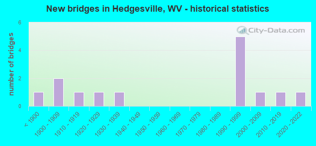
- New bridges - historical statistics
- 1Before 1900
- 21900-1909
- 11910-1919
- 11920-1929
- 11930-1939
- 51990-1999
- 12000-2009
- 12010-2019
- 12020-2022


- Bridge Condition - Deck
- 12.5%Very good
- 37.5%Good
- 12.5%Satisfactory
- 25.0%Fair
- 12.5%Poor

- Bridge Condition - Superstructure
- 25.0%Very good
- 37.5%Good
- 12.5%Satisfactory
- 12.5%Fair
- 12.5%Poor

- Bridge Condition - Substructure
- 12.5%Very good
- 50.0%Good
- 12.5%Satisfactory
- 25.0%Fair

- Bridge Condition - Channel
- 11.1%Very good
- 44.4%Good
- 33.3%Satisfactory
- 11.1%Fair
Find on map >> Show street view
Structure Number: 2A003, Location: 0.07 MI N OF CR 8/1 SLS (Lat: 39.550981, Lng: -77.954881), Route carried "on" structure: County highway 100, Year Built: 1930, Status: Posted for load, Structure Length: 0.79m (2.59ft), Average Daily Traffic: 950 (year 2019), Truck Traffic: 2%, Average Future Daily Traffic: 1,188 (year 2039), Features Intersected: HARLAN RUN, Facility Carried by Structure: COUNTY ROAD 01 SLS
Minimum Vertical Clearance: 30+ m (98+ ft), Kilometerpoint: 5.520, Lanes on structure: 2, Owner: State Highway Agency, Approaching Roadway Width: 6.7m (22.0ft), Skew: 4 degrees, Material/Design: Concrete, Design/Construction: Slab, Number Of Spans In Main Unit: 1, Length of Maximum Span: 6.6m (21.7ft), Curb or Sidewalk Widths: Left: 0.2m (0.7ft), Right: 0.0m, Curb-To-Curb Width: 8.0m (26.2ft), Out-to-Out Width: 8.5m (27.9ft)
Condition: Deck: Fair, Superstructure: Fair, Substructure: Fair, Channel: Good, Operating Rating: 47.2 metric tons, Method Used To Determine Operating Rating: Field evaluation and documented engineering judgment, Inventory Rating: 21.8 metric tons, Method Used To Determine Inventory Rating: Field evaluation and documented engineering judgment, Structural Evaluation: Somewhat better than minimum adequacy, Deck Geometry: Somewhat better than minimum adequacy, Waterway Adequacy: Equal to present minimum criteria, Approach Roadway Alignment: Meets minimum limits, Length Of Structure Improvement: 1.22m (4.00ft), Designated Inspection Frequency: Every 24 months, Inspection Date: December 2020, Bridge Improvement Cost: $125,000, Roadway Improvement Cost: $25,000, Total Project Cost: $150,000 ( Estimate for 2016), Deck Structure Type: Concrete Cast-file-Place, Wearing Surface/Protective System: Wearing Surface: Bituminous
Find on map >> Show street view
Structure Number: 2A022, Location: 0.42 MI EAST OF CR 07 (Lat: 39.555961, Lng: -78.017631), Route carried "on" structure: State highway 9, Year Built: 1992, Status: Open, Structure Length: 8.37m (27.46ft), Average Daily Traffic: 12,100 (year 2018), Truck Traffic: 5%, Average Future Daily Traffic: 15,004 (year 2038), Design Load: HS 25 or greater, Features Intersected: BACK CREEK
Minimum Vertical Clearance: 30+ m (98+ ft), Kilometerpoint: 7.741, Lanes on structure: 2, Base Highway Network: Yes, Owner: State Highway Agency, Approaching Roadway Width: 10.7m (35.1ft), Skew: 1 degrees, Material/Design: Steel continuous, Design/Construction: Stringer/Multi-beam, Number Of Spans In Main Unit: 1, Number Of Approach Spans: 2, Length of Maximum Span: 33.5m (109.9ft), Curb or Sidewalk Widths: Left: 0.2m (0.7ft), Right: 0.2m (0.7ft), Curb-To-Curb Width: 10.6m (34.8ft), Out-to-Out Width: 11.7m (38.4ft)
Condition: Deck: Fair, Superstructure: Good, Substructure: Good, Channel: Satisfactory, Operating Rating: 69.8 metric tons, Method Used To Determine Operating Rating: Load Factor (LF), Inventory Rating: 41.7 metric tons, Method Used To Determine Inventory Rating: Load Factor (LF), Structural Evaluation: Better than present minimum criteria, Deck Geometry: Meets minimum limits, Waterway Adequacy: Superior to present desirable criteria, Approach Roadway Alignment: Better than present minimum criteria, Designated Inspection Frequency: Every 24 months, Inspection Date: September 2020, Deck Structure Type: Concrete Cast-file-Place, Wearing Surface/Protective System: Deck Protection: Epoxy Coated Reinforcing
Find on map >> Show street view
Structure Number: 2A023, Location: 0.30 MI W OF CR 04 SLS (Lat: 39.539100, Lng: -77.985069), Route carried "on" structure: State highway 900, Year Built: 1922, Status: Posted for load, Structure Length: 0.70m (2.30ft), Average Daily Traffic: 16,500 (year 2020), Truck Traffic: 7%, Average Future Daily Traffic: 23,430 (year 2040), Features Intersected: TULISSUS BRANCH, Facility Carried by Structure: WV 09 (F)
Minimum Vertical Clearance: 30+ m (98+ ft), Kilometerpoint: 12.199, Lanes on structure: 2, Base Highway Network: Yes, Owner: State Highway Agency, Approaching Roadway Width: 8.5m (27.9ft), Material/Design: Concrete, Design/Construction: Slab, Number Of Spans In Main Unit: 1, Length of Maximum Span: 6.2m (20.3ft), Curb-To-Curb Width: 9.5m (31.2ft), Out-to-Out Width: 10.0m (32.8ft)
Condition: Deck: Poor, Superstructure: Poor, Substructure: Fair, Channel: Fair, Operating Rating: 38.1 metric tons, Method Used To Determine Operating Rating: Field evaluation and documented engineering judgment, Inventory Rating: 17.2 metric tons, Method Used To Determine Inventory Rating: Field evaluation and documented engineering judgment, Structural Evaluation: Meets minimum limits, Deck Geometry: High priority of corrective action, Waterway Adequacy: Equal to present desirable criteria, Approach Roadway Alignment: Equal to present desirable criteria, Bridge Posting: Required (Relationship of Operating Rating to Maximum Legal Load: 0.1 - 9.9% below), Length Of Structure Improvement: 1.52m (4.99ft), Designated Inspection Frequency: Every 24 months, Other Special Inspection Frequency: Every 12 months, Inspection Date: September 2021, Other Special Inspection Date: September 2021, Bridge Improvement Cost: $500,000, Roadway Improvement Cost: $250,000, Total Project Cost: $750,000 ( Estimate for 2016), Deck Structure Type: Concrete Cast-file-Place, Wearing Surface/Protective System: Wearing Surface: Bituminous
Find on map >> Show street view
Structure Number: 2A035, Location: 0.69 MI W OF WV 9 F (Lat: 39.575531, Lng: -78.050619), Route carried "on" structure: County highway 904, Year Built: 1993, Status: Open, Structure Length: 1.83m (6.00ft), Average Daily Traffic: 450 (year 2018), Truck Traffic: 4%, Average Future Daily Traffic: 623 (year 2038), Design Load: HS 25 or greater, Features Intersected: TILHANCE CREEK, Facility Carried by Structure: CR 9/4 SLS
Minimum Vertical Clearance: 30+ m (98+ ft), Kilometerpoint: 3.219, Lanes on structure: 2, Owner: State Highway Agency, Approaching Roadway Width: 7.6m (24.9ft), Skew: 2 degrees, Material/Design: Steel, Design/Construction: Box Beam or Girders - Multiple, Number Of Spans In Main Unit: 1, Length of Maximum Span: 17.1m (56.1ft), Curb-To-Curb Width: 7.1m (23.3ft), Out-to-Out Width: 7.4m (24.3ft)
Condition: Deck: Good, Superstructure: Good, Substructure: Good, Channel: Satisfactory, Operating Rating: 88.9 metric tons, Method Used To Determine Operating Rating: Load Factor (LF), Inventory Rating: 53.5 metric tons, Method Used To Determine Inventory Rating: Load Factor (LF), Structural Evaluation: Better than present minimum criteria, Deck Geometry: Meets minimum limits, Waterway Adequacy: Equal to present minimum criteria, Approach Roadway Alignment: Equal to present minimum criteria, Designated Inspection Frequency: Every 48 months, Inspection Date: December 2019, Deck Structure Type: Other, Wearing Surface/Protective System: Wearing Surface: Bituminous, Deck Protection: Epoxy Coated Reinforcing
Find on map >> Show street view
Structure Number: 2A113, Location: 0.85 MI N OF WV 901 F (Lat: 39.574081, Lng: -77.980839), Route carried "on" structure: County highway 302, Year Built: 1991, Status: Open, Structure Length: 2.28m (7.48ft), Average Daily Traffic: 1,200 (year 2018), Truck Traffic: 2%, Average Future Daily Traffic: 1,500 (year 2038), Features Intersected: LCS SERVICES PRIVATE DRI, Facility Carried by Structure: CR 3/2 SLS
Minimum Vertical Clearance: 30+ m (98+ ft), Kilometerpoint: 1.368, Lanes on structure: 2, Owner: State Highway Agency, Approaching Roadway Width: 8.2m (26.9ft), Skew: 5 degrees, Material/Design: Steel, Design/Construction: Culvert, Number Of Spans In Main Unit: 2, Length of Maximum Span: 6.1m (20.0ft), Curb or Sidewalk Widths: Left: 0.9m (3.0ft), Right: 0.9m (3.0ft)
Condition: Culverts: Satisfactory, Operating Rating: 71.7 metric tons, Method Used To Determine Operating Rating: Field evaluation and documented engineering judgment, Inventory Rating: 32.7 metric tons, Method Used To Determine Inventory Rating: Field evaluation and documented engineering judgment, Structural Evaluation: Equal to present minimum criteria, Approach Roadway Alignment: Equal to present desirable criteria, Designated Inspection Frequency: Every 48 months, Inspection Date: October 2019
Find on map >> Show street view
Structure Number: 2A114, Location: 0.55 MI. E. OF CR 07 SLS (Lat: 39.556561, Lng: -78.015981), Route carried "on" structure: State highway 900, Year Built: 1992, Status: Open, Structure Length: 0.87m (2.85ft), Average Daily Traffic: 13,200 (year 2020), Truck Traffic: 7%, Average Future Daily Traffic: 18,744 (year 2040), Design Load: HS 25 or greater, Features Intersected: BRANCH OF BACK CK., Facility Carried by Structure: WV.09 T.
Minimum Vertical Clearance: 30+ m (98+ ft), Kilometerpoint: 7.950, Lanes on structure: 2, Base Highway Network: Yes, Owner: State Highway Agency, Approaching Roadway Width: 11.0m (36.1ft), Skew: 6 degrees, Material/Design: Concrete, Design/Construction: Culvert, Number Of Spans In Main Unit: 1, Length of Maximum Span: 8.7m (28.5ft)
Condition: Channel: Satisfactory, Culverts: Satisfactory, Operating Rating: 88.9 metric tons, Method Used To Determine Operating Rating: Field evaluation and documented engineering judgment, Inventory Rating: 40.8 metric tons, Method Used To Determine Inventory Rating: Field evaluation and documented engineering judgment, Structural Evaluation: Equal to present minimum criteria, Waterway Adequacy: Equal to present minimum criteria, Approach Roadway Alignment: Equal to present minimum criteria, Designated Inspection Frequency: Every 24 months, Inspection Date: November 2021
Find on map >> Show street view
Structure Number: 2A117, Location: 0.12 MI W OF CR 01 SLS (Lat: 39.559219, Lng: -77.954969), Route carried "on" structure: State highway 90100, Year Built: 1997, Status: Open, Structure Length: 1.92m (6.30ft), Average Daily Traffic: 3,900 (year 2018), Truck Traffic: 5%, Average Future Daily Traffic: 4,875 (year 2038), Design Load: HS 25 or greater, Features Intersected: HARLAN RUN, Facility Carried by Structure: WV 901 F
Minimum Vertical Clearance: 30+ m (98+ ft), Kilometerpoint: 4.249, Lanes on structure: 2, Owner: State Highway Agency, Approaching Roadway Width: 6.4m (21.0ft), Skew: 2 degrees, Material/Design: Prestressed concrete, Design/Construction: Box Beam or Girders - Multiple, Number Of Spans In Main Unit: 1, Length of Maximum Span: 17.9m (58.7ft), Curb-To-Curb Width: 10.7m (35.1ft), Out-to-Out Width: 11.2m (36.7ft)
Condition: Deck: Satisfactory, Superstructure: Satisfactory, Substructure: Satisfactory, Channel: Good, Operating Rating: 47.2 metric tons, Method Used To Determine Operating Rating: Load Factor (LF), Inventory Rating: 28.1 metric tons, Method Used To Determine Inventory Rating: Load Factor (LF), Structural Evaluation: Equal to present minimum criteria, Deck Geometry: Somewhat better than minimum adequacy, Waterway Adequacy: Equal to present minimum criteria, Approach Roadway Alignment: Somewhat better than minimum adequacy, Designated Inspection Frequency: Every 48 months, Inspection Date: March 2020, Deck Structure Type: Other, Wearing Surface/Protective System: Wearing Surface: Bituminous, Deck Protection: Epoxy Coated Reinforcing
Find on map >> Show street view
Structure Number: 2A137, Location: 0.01 MI S OF CR 4/1 SLS (Lat: 39.551011, Lng: -77.974819), Route carried "on" structure: County highway 400, Year Built: 2006, Status: Open, Structure Length: 1.09m (3.58ft), Average Daily Traffic: 500 (year 2019), Truck Traffic: 2%, Average Future Daily Traffic: 625 (year 2039), Design Load: HS 25 or greater, Features Intersected: TULISSUS BRANCH, Facility Carried by Structure: CR 04 SLS
Minimum Vertical Clearance: 30+ m (98+ ft), Kilometerpoint: 7.145, Lanes on structure: 2, Owner: State Highway Agency, Approaching Roadway Width: 5.8m (19.0ft), Skew: 2 degrees, Material/Design: Prestressed concrete, Design/Construction: Box Beam or Girders - Multiple, Number Of Spans In Main Unit: 1, Length of Maximum Span: 9.8m (32.2ft), Curb-To-Curb Width: 7.0m (23.0ft), Out-to-Out Width: 7.4m (24.3ft)
Condition: Deck: Good, Superstructure: Good, Substructure: Good, Channel: Good, Operating Rating: 71.7 metric tons, Method Used To Determine Operating Rating: Load Factor (LF), Inventory Rating: 42.6 metric tons, Method Used To Determine Inventory Rating: Load Factor (LF), Structural Evaluation: Better than present minimum criteria, Deck Geometry: Meets minimum limits, Waterway Adequacy: Equal to present desirable criteria, Approach Roadway Alignment: Equal to present minimum criteria, Designated Inspection Frequency: Every 48 months, Inspection Date: January 2021, Deck Structure Type: Other, Wearing Surface/Protective System: Wearing Surface: Bituminous, Deck Protection: Epoxy Coated Reinforcing
Find on map >> Show street view
Structure Number: 2A162, Location: 0.04 m. west of CR 9/9 (Lat: 39.512850, Lng: -78.036231), Route carried "on" structure: County highway 6, Year Built: 2013, Status: Open, Structure Length: 3.98m (13.06ft), Average Daily Traffic: 150 (year 2019), Truck Traffic: 2%, Average Future Daily Traffic: 188 (year 2039), Design Load: HL 93, Features Intersected: Back Creek
Minimum Vertical Clearance: 30+ m (98+ ft), Kilometerpoint: 1.545, Lanes on structure: 2, Owner: State Highway Agency, Approaching Roadway Width: 7.3m (24.0ft), Material/Design: Steel, Design/Construction: Stringer/Multi-beam, Number Of Spans In Main Unit: 1, Length of Maximum Span: 39.1m (128.3ft), Curb-To-Curb Width: 7.3m (24.0ft), Out-to-Out Width: 8.1m (26.6ft)
Condition: Deck: Good, Superstructure: Very good, Substructure: Good, Channel: Good, Operating Rating: 47.2 metric tons, Method Used To Determine Operating Rating: Load and Resistance Factor (LRFR), Inventory Rating: 36.3 metric tons, Method Used To Determine Inventory Rating: Load and Resistance Factor (LRFR), Structural Evaluation: Better than present minimum criteria, Deck Geometry: Somewhat better than minimum adequacy, Waterway Adequacy: Somewhat better than minimum adequacy, Approach Roadway Alignment: Meets minimum limits, Designated Inspection Frequency: Every 24 months, Inspection Date: June 2021, Deck Structure Type: Concrete Cast-file-Place, Wearing Surface/Protective System: Deck Protection: Epoxy Coated Reinforcing
Find on map >> Show street view
Structure Number: 2A176, Location: 0.30 Mi E. of CR 9/5 (Lat: 39.574419, Lng: -78.037269), Route carried "on" structure: State highway 900, Year Built: 2020, Status: Open, Structure Length: 1.84m (6.04ft), Average Daily Traffic: 8,500 (year 2019), Truck Traffic: 5%, Average Future Daily Traffic: 10,500 (year 2039), Design Load: HL 93, Features Intersected: Tilhance Creek, Facility Carried by Structure: WV 09 (T)
Minimum Vertical Clearance: 30+ m (98+ ft), Kilometerpoint: 4.088, Lanes on structure: 2, Base Highway Network: Yes, Owner: State Highway Agency, Approaching Roadway Width: 8.5m (27.9ft), Material/Design: Prestressed concrete, Design/Construction: Box Beam or Girders - Single/Spread, Number Of Spans In Main Unit: 1, Length of Maximum Span: 18.4m (60.4ft), Curb-To-Curb Width: 9.8m (32.2ft), Out-to-Out Width: 10.6m (34.8ft)
Condition: Deck: Very good, Superstructure: Very good, Substructure: Very good, Channel: Very good, Operating Rating: 49.9 metric tons, Method Used To Determine Operating Rating: Load and Resistance Factor (LRFR), Inventory Rating: 39.0 metric tons, Method Used To Determine Inventory Rating: Load and Resistance Factor (LRFR), Structural Evaluation: Equal to present desirable criteria, Deck Geometry: Meets minimum limits, Waterway Adequacy: Better than present minimum criteria, Approach Roadway Alignment: Equal to present minimum criteria, Designated Inspection Frequency: Every 24 months, Inspection Date: November 2020, Deck Structure Type: Concrete Cast-file-Place, Wearing Surface/Protective System: Wearing Surface: Monolithic Concrete, Deck Protection: Epoxy Coated Reinforcing
Find on map >> Show street view
Structure Number: 2A01, Location: 0.04 MI W JCT. CR 9/9 SLS (Lat: 39.512761, Lng: -78.036231), Route carried "under" structure: County highway 600, Year Built: 1892, Structure Length: 0. m, Features Intersected: BACK CREEK, Facility Carried by Structure: Closed to Vehicles
Minimum Vertical Clearance: 2.82m (9.25ft), Kilometerpoint: 1.545, Material/Design: Aluminum, Iron, Length of Maximum Span: 28.3m (92.8ft)
Find on map >> Show street view
Structure Number: 2A107, Location: 0.36 MI N OF CR 02 SLS (Lat: 39.576139, Lng: -77.968561), Route carried "under" structure: County highway 202, Year Built: 1903, Structure Length: 0. m, Average Daily Traffic: 450 (year 2019), Truck Traffic: 2%, Features Intersected: CSXT RR, Facility Carried by Structure: CSX CORP RAILROAD
Minimum Vertical Clearance: 3.84m (12.60ft), Kilometerpoint: 0.579, Lanes under structure: 1, Material/Design: Masonry, Design/Construction: Arch - Deck, Length of Maximum Span: 4.6m (15.1ft)
Find on map >> Show street view
Structure Number: 2A109, Location: 0.18 MI E OF CR 2/2 SLS (Lat: 39.583600, Lng: -77.966461), Route carried "under" structure: County highway 204, Year Built: 1903, Structure Length: 0. m, Average Daily Traffic: 50 (year 2019), Features Intersected: CSXT RR, Facility Carried by Structure: CSX CORP RAILROAD
Minimum Vertical Clearance: 3.81m (12.50ft), Kilometerpoint: 0.290, Lanes under structure: 1, Material/Design: Masonry, Design/Construction: Arch - Deck, Length of Maximum Span: 4.9m (16.1ft)
Find on map >> Show street view
Structure Number: 2A11, Location: 0.41 MI S OF CR 4/1 SLS (Lat: 39.546000, Lng: -77.974689), Route carried "under" structure: County highway 400, Year Built: 1911, Structure Length: 0. m, Average Daily Traffic: 500 (year 2019), Truck Traffic: 2%, Features Intersected: CR 4 (SLS), Facility Carried by Structure: CSXT RAILROAD
Minimum Vertical Clearance: 3.58m (11.75ft), Kilometerpoint: 6.502, Lanes under structure: 1, Material/Design: Concrete, Design/Construction: Slab, Length of Maximum Span: 4.4m (14.4ft)