Bridge Statistics for Hedley, Texas (TX)
Condition, Traffic, Stress, Structural Evaluation, Project Costs
- National Bridge Inventory (NBI) Statistics
- 10Number of bridges
- 49ft / 14.6mTotal length
- 35,369Total average daily traffic
- 13,153Total average daily truck traffic
- 47,976Total future (year 2030) average daily traffic
- National Bridge Inventory (NBI) Registered Bridges for Hedley
- No street view available for this location
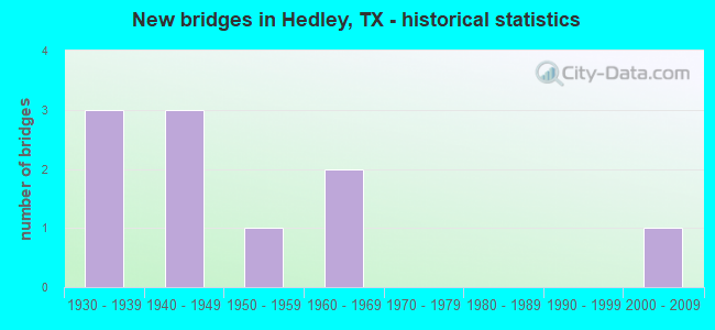
- New bridges - historical statistics
- 31930-1939
- 31940-1949
- 11950-1959
- 21960-1969
- 12000-2009

- Reconstructed bridges - Historical Statistics
- 11940-1949
- 01950-1959
- 01960-1969
- 01970-1979
- 21980-1989


- Bridge Condition - Superstructure
- 50.0%Good
- 50.0%Satisfactory

- Bridge Condition - Channel
- 20.0%Very good
- 30.0%Good
- 50.0%Satisfactory

- Bridge Condition - Culverts
- 25.0%Good
- 75.0%Satisfactory
Find on map >> Show street view
Structure Number: 250650004207033, Location: 11.1MI E CLARENDON CTY LT (Lat: 34.870456, Lng: -100.696617), Route carried "on" structure: US 287, Year Built: 1935, Year Reconstructed: 1954, Status: Open, Structure Length: 2.62m (8.60ft), Average Daily Traffic: 5,990 (year 2013), Truck Traffic: 38%, Average Future Daily Traffic: 8,390 (year 2033), Design Load: H 15, Features Intersected: BELL CREEK
Minimum Vertical Clearance: 30+ m (98+ ft), Kilometerpoint: 39.622, Lanes on structure: 2, Owner: State Highway Agency, Approaching Roadway Width: 11.6m (38.1ft), Skew: 10 degrees, Material/Design: Concrete, Design/Construction: Tee Beam, Number Of Spans In Main Unit: 3, Length of Maximum Span: 8.8m (28.9ft), Curb-To-Curb Width: 13.3m (43.6ft), Out-to-Out Width: 14.0m (45.9ft)
Condition: Deck: Good, Superstructure: Satisfactory, Substructure: Satisfactory, Channel: Very good, Operating Rating: 51.7 metric tons, Method Used To Determine Operating Rating: Load Factor (LF), Inventory Rating: 30.8 metric tons, Method Used To Determine Inventory Rating: Load Factor (LF), Structural Evaluation: Equal to present minimum criteria, Deck Geometry: Superior to present desirable criteria, Waterway Adequacy: Equal to present minimum criteria, Approach Roadway Alignment: Equal to present desirable criteria, Designated Inspection Frequency: Every 24 months, Inspection Date: July 2021, Deck Structure Type: Concrete Cast-file-Place, Wearing Surface/Protective System: Wearing Surface: Bituminous
Find on map >> Show street view
Structure Number: 250650004207064, Location: 11.1MI E CLARENDON CTY LT (Lat: 34.870281, Lng: -100.696636), Route carried "on" structure: US 287, Year Built: 1967, Status: Open, Structure Length: 3.66m (12.01ft), Average Daily Traffic: 5,990 (year 2013), Truck Traffic: 38%, Average Future Daily Traffic: 8,390 (year 2033), Design Load: H 20, Features Intersected: BELL CREEK
Minimum Vertical Clearance: 30+ m (98+ ft), Kilometerpoint: 39.622, Lanes on structure: 2, Owner: State Highway Agency, Approaching Roadway Width: 11.3m (37.1ft), Skew: 10 degrees, Material/Design: Concrete, Design/Construction: Stringer/Multi-beam, Number Of Spans In Main Unit: 3, Length of Maximum Span: 12.2m (40.0ft), Curb-To-Curb Width: 12.2m (40.0ft), Out-to-Out Width: 12.9m (42.3ft)
Condition: Deck: Good, Superstructure: Good, Substructure: Satisfactory, Channel: Very good, Operating Rating: 49.9 metric tons, Method Used To Determine Operating Rating: Load Factor (LF), Inventory Rating: 29.9 metric tons, Method Used To Determine Inventory Rating: Load Factor (LF), Structural Evaluation: Equal to present minimum criteria, Deck Geometry: Better than present minimum criteria, Waterway Adequacy: Equal to present minimum criteria, Approach Roadway Alignment: Equal to present desirable criteria, Designated Inspection Frequency: Every 24 months, Inspection Date: July 2021, Deck Structure Type: Concrete Cast-file-Place, Wearing Surface/Protective System: Wearing Surface: Bituminous
Find on map >> Show street view
Structure Number: 250650004208019, Location: 1.1MI E OF HEDLEY CTY LMT (Lat: 34.847764, Lng: -100.642617), Route carried "on" structure: US 287, Year Built: 1935, Year Reconstructed: 1980, Status: Open, Structure Length: 1.01m (3.31ft), Average Daily Traffic: 10,959 (year 2020), Truck Traffic: 38%, Average Future Daily Traffic: 14,480 (year 2033), Design Load: H 15, Features Intersected: FORK OF BUCK CREEK
Minimum Vertical Clearance: 30+ m (98+ ft), Kilometerpoint: 1.640, Lanes on structure: 4, Owner: State Highway Agency, Approaching Roadway Width: 23.8m (78.1ft), Skew: 10 degrees, Material/Design: Concrete, Design/Construction: Culvert, Number Of Spans In Main Unit: 3, Length of Maximum Span: 3.0m (9.8ft)
Condition: Channel: Satisfactory, Culverts: Satisfactory, Operating Rating: 39.9 metric tons, Method Used To Determine Operating Rating: Load Factor (LF), Inventory Rating: 23.6 metric tons, Method Used To Determine Inventory Rating: Load Factor (LF), Structural Evaluation: Somewhat better than minimum adequacy, Waterway Adequacy: Equal to present minimum criteria, Approach Roadway Alignment: Equal to present desirable criteria, Designated Inspection Frequency: Every 24 months, Inspection Date: July 2021
Find on map >> Show street view
Structure Number: 25065000420802, Location: 1.8MI E OF HEDLEY CTY LMT (Lat: 34.839972, Lng: -100.631567), Route carried "on" structure: US 287, Year Built: 1935, Year Reconstructed: 1980, Status: Open, Structure Length: 1.04m (3.41ft), Average Daily Traffic: 10,959 (year 2020), Truck Traffic: 38%, Average Future Daily Traffic: 14,480 (year 2033), Design Load: H 15, Features Intersected: FORK OF BUCK CREEK
Minimum Vertical Clearance: 30+ m (98+ ft), Kilometerpoint: 2.911, Lanes on structure: 4, Owner: State Highway Agency, Approaching Roadway Width: 23.5m (77.1ft), Skew: 10 degrees, Material/Design: Concrete, Design/Construction: Culvert, Number Of Spans In Main Unit: 5, Length of Maximum Span: 1.8m (5.9ft)
Condition: Channel: Satisfactory, Culverts: Satisfactory, Operating Rating: 39.9 metric tons, Method Used To Determine Operating Rating: Load Factor (LF), Inventory Rating: 23.6 metric tons, Method Used To Determine Inventory Rating: Load Factor (LF), Structural Evaluation: Somewhat better than minimum adequacy, Waterway Adequacy: Equal to present minimum criteria, Approach Roadway Alignment: Equal to present desirable criteria, Designated Inspection Frequency: Every 24 months, Inspection Date: July 2021
Find on map >> Show street view
Structure Number: 250650044801005, Location: 1.40 MI NE OF HEDLEY (Lat: 34.879958, Lng: -100.645381), Route carried "on" structure: State highway 203, Year Built: 1947, Status: Open, Structure Length: 1.16m (3.81ft), Average Daily Traffic: 495 (year 2020), Truck Traffic: 20%, Average Future Daily Traffic: 880 (year 2033), Design Load: H 15, Features Intersected: DRAW
Minimum Vertical Clearance: 30+ m (98+ ft), Kilometerpoint: 2.279, Lanes on structure: 2, Owner: State Highway Agency, Approaching Roadway Width: 7.9m (25.9ft), Skew: 3 degrees, Material/Design: Concrete, Design/Construction: Culvert, Number Of Spans In Main Unit: 5, Length of Maximum Span: 1.8m (5.9ft), Curb-To-Curb Width: 7.9m (25.9ft), Out-to-Out Width: 13.6m (44.6ft)
Condition: Channel: Satisfactory, Culverts: Good, Operating Rating: 39.9 metric tons, Method Used To Determine Operating Rating: Load Factor (LF), Inventory Rating: 23.6 metric tons, Method Used To Determine Inventory Rating: Load Factor (LF), Structural Evaluation: Equal to present minimum criteria, Deck Geometry: Somewhat better than minimum adequacy, Waterway Adequacy: Equal to present minimum criteria, Approach Roadway Alignment: Equal to present desirable criteria, Designated Inspection Frequency: Every 24 months, Inspection Date: July 2021, Deck Structure Type: Concrete Cast-file-Place, Wearing Surface/Protective System: Wearing Surface: Bituminous
Find on map >> Show street view
Structure Number: 250650044801006, Location: 2.80 MI NE OF HEDLEY (Lat: 34.886800, Lng: -100.622158), Route carried "on" structure: State highway 203, Year Built: 1947, Status: Open, Structure Length: 0.67m (2.20ft), Average Daily Traffic: 367 (year 2020), Truck Traffic: 19%, Average Future Daily Traffic: 430 (year 2033), Design Load: H 15, Features Intersected: DRAW
Minimum Vertical Clearance: 30+ m (98+ ft), Kilometerpoint: 4.468, Lanes on structure: 2, Owner: State Highway Agency, Approaching Roadway Width: 8.5m (27.9ft), Material/Design: Concrete, Design/Construction: Culvert, Number Of Spans In Main Unit: 3, Length of Maximum Span: 2.1m (6.9ft)
Condition: Channel: Good, Culverts: Satisfactory, Operating Rating: 39.9 metric tons, Method Used To Determine Operating Rating: Load Factor (LF), Inventory Rating: 23.6 metric tons, Method Used To Determine Inventory Rating: Load Factor (LF), Structural Evaluation: Equal to present minimum criteria, Waterway Adequacy: Equal to present minimum criteria, Approach Roadway Alignment: Equal to present desirable criteria, Designated Inspection Frequency: Every 24 months, Inspection Date: July 2021
Find on map >> Show street view
Structure Number: 250650044801007, Location: 3.65 MI NE OF HEDLEY (Lat: 34.891128, Lng: -100.607347), Route carried "on" structure: State highway 203, Year Built: 1947, Status: Open, Structure Length: 0.98m (3.22ft), Average Daily Traffic: 367 (year 2020), Truck Traffic: 19%, Average Future Daily Traffic: 430 (year 2033), Design Load: H 15, Features Intersected: DRAW
Minimum Vertical Clearance: 30+ m (98+ ft), Kilometerpoint: 5.837, Lanes on structure: 2, Owner: State Highway Agency, Approaching Roadway Width: 8.5m (27.9ft), Skew: 4 degrees, Material/Design: Concrete, Design/Construction: Culvert, Number Of Spans In Main Unit: 3, Length of Maximum Span: 2.1m (6.9ft)
Condition: Channel: Satisfactory, Culverts: Satisfactory, Operating Rating: 39.9 metric tons, Method Used To Determine Operating Rating: Load Factor (LF), Inventory Rating: 23.6 metric tons, Method Used To Determine Inventory Rating: Load Factor (LF), Structural Evaluation: Equal to present minimum criteria, Waterway Adequacy: Equal to present minimum criteria, Approach Roadway Alignment: Equal to present desirable criteria, Designated Inspection Frequency: Every 24 months, Inspection Date: July 2021
Find on map >> Show street view
Structure Number: 250650056004023, Location: 1.95 MI N OF SH 203 (Lat: 34.911061, Lng: -100.636031), Route carried "on" structure: State highway 273, Year Built: 1966, Status: Open, Structure Length: 1.52m (4.99ft), Average Daily Traffic: 106 (year 2020), Truck Traffic: 19%, Average Future Daily Traffic: 300 (year 2033), Features Intersected: OKLAHOMA DRAW
Minimum Vertical Clearance: 30+ m (98+ ft), Kilometerpoint: 34.424, Lanes on structure: 2, Owner: State Highway Agency, Approaching Roadway Width: 6.7m (22.0ft), Skew: 3 degrees, Material/Design: Concrete, Design/Construction: Culvert, Number Of Spans In Main Unit: 4, Length of Maximum Span: 3.0m (9.8ft)
Condition: Channel: Good, Culverts: Good, Operating Rating: 39.9 metric tons, Method Used To Determine Operating Rating: Load Factor (LF), Inventory Rating: 23.6 metric tons, Method Used To Determine Inventory Rating: Load Factor (LF), Structural Evaluation: Equal to present minimum criteria, Waterway Adequacy: Equal to present minimum criteria, Approach Roadway Alignment: Equal to present desirable criteria, Designated Inspection Frequency: Every 24 months, Inspection Date: July 2021
Find on map >> Show street view
Structure Number: 250650181801001, Location: 0.40MI W OF SH70 (Lat: 34.869497, Lng: -100.666789), Route carried "on" structure: State highway 1932, Year Built: 1953, Status: Open, Structure Length: 0.85m (2.79ft), Average Daily Traffic: 100 (year 2020), Truck Traffic: 16%, Average Future Daily Traffic: 160 (year 2033), Features Intersected: DRAW
Minimum Vertical Clearance: 30+ m (98+ ft), Kilometerpoint: 28.553, Lanes on structure: 2, Owner: State Highway Agency, Approaching Roadway Width: 5.5m (18.0ft), Skew: 4 degrees, Material/Design: Concrete, Design/Construction: Culvert, Number Of Spans In Main Unit: 3, Length of Maximum Span: 1.8m (5.9ft), Curb-To-Curb Width: 5.5m (18.0ft), Out-to-Out Width: 9.5m (31.2ft)
Condition: Channel: Satisfactory, Culverts: Satisfactory, Operating Rating: 39.9 metric tons, Method Used To Determine Operating Rating: Load Factor (LF), Inventory Rating: 23.6 metric tons, Method Used To Determine Inventory Rating: Load Factor (LF), Structural Evaluation: Equal to present minimum criteria, Deck Geometry: Meets minimum limits, Waterway Adequacy: Better than present minimum criteria, Approach Roadway Alignment: Equal to present desirable criteria, Designated Inspection Frequency: Every 24 months, Inspection Date: June 2021, Deck Structure Type: Concrete Cast-file-Place, Wearing Surface/Protective System: Wearing Surface: Bituminous
Find on map >> Show street view
Structure Number: 250650AA0155001, Location: 0.6 MI N OF US 287 (Lat: 34.835381, Lng: -100.610814), Route carried "on" structure: County highway , Year Built: 2008, Status: Open, Structure Length: 1.10m (3.61ft), Average Daily Traffic: 36 (year 2010), Average Future Daily Traffic: 36 (year 2030), Design Load: HS 20, Features Intersected: S FK BUCK CR, Facility Carried by Structure: CR 28
Minimum Vertical Clearance: 30+ m (98+ ft), Kilometerpoint: 5.472, Lanes on structure: 2, Owner: County Highway Agency, Approaching Roadway Width: 5.5m (18.0ft), Material/Design: Concrete, Design/Construction: Culvert, Number Of Spans In Main Unit: 3, Length of Maximum Span: 3.0m (9.8ft)
Condition: Channel: Good, Culverts: Satisfactory, Operating Rating: 54.4 metric tons, Method Used To Determine Operating Rating: Assigned rating based on Load Factor Design (LFD) reported in metric tons, Inventory Rating: 32.7 metric tons, Method Used To Determine Inventory Rating: Assigned rating based on Load Factor Design (LFD) reported in metric tons, Structural Evaluation: Equal to present minimum criteria, Waterway Adequacy: Superior to present desirable criteria, Approach Roadway Alignment: Somewhat better than minimum adequacy, Designated Inspection Frequency: Every 24 months, Inspection Date: September 2020