Bridge Statistics for Helena Valley Northeast, Montana (MT)
Condition, Traffic, Stress, Structural Evaluation, Project Costs
- National Bridge Inventory (NBI) Statistics
- 22Number of bridges
- 230ft / 70.5mTotal length
- $174,000Total costs
- 78,148Total average daily traffic
- 4,854Total average daily truck traffic
- National Bridge Inventory (NBI) Registered Bridges for Helena Valley Northeast
- No street view available for this location
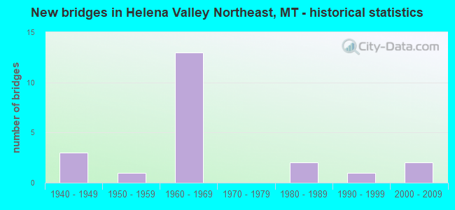
- New bridges - historical statistics
- 31940-1949
- 11950-1959
- 131960-1969
- 21980-1989
- 11990-1999
- 22000-2009

- Reconstructed bridges - Historical Statistics
- 11980-1989
- 01990-1999
- 12000-2009


- Bridge Condition - Deck
- 5.9%Very good
- 76.5%Good
- 5.9%Satisfactory
- 5.9%Fair
- 5.9%Poor

- Bridge Condition - Superstructure
- 41.2%Very good
- 52.9%Good
- 5.9%Satisfactory

- Bridge Condition - Substructure
- 17.6%Very good
- 52.9%Good
- 23.5%Satisfactory
- 5.9%Fair

- Bridge Condition - Channel
- 16.7%Very good
- 66.7%Good
- 16.7%Satisfactory
Find on map >> Show street view
Structure Number: 202008015, Location: 5M NE HELENA (Lat: 46.662706, Lng: -111.976514), Route carried "on" structure: ServiceCounty highway , Year Built: 1940, Status: Posted for load, Structure Length: 1.58m (5.18ft), Average Daily Traffic: 100 (year 2022), Truck Traffic: 3%, Average Future Daily Traffic: 100 (year 2037), Features Intersected: PRICKELY PEAR CREEK, Facility Carried by Structure: Unknown
Minimum Vertical Clearance: 30+ m (98+ ft), Kilometerpoint: 0.000, Lanes on structure: 1, Owner: State Agenciy, Approaching Roadway Width: 4.6m (15.1ft), Material/Design: Wood or Timber, Design/Construction: Stringer/Multi-beam, Number Of Spans In Main Unit: 2, Length of Maximum Span: 7.6m (24.9ft), Curb or Sidewalk Widths: Left: 0.2m (0.7ft), Right: 0.7m (2.3ft), Curb-To-Curb Width: 5.5m (18.0ft), Out-to-Out Width: 5.6m (18.4ft)
Condition: Deck: Good, Superstructure: Good, Substructure: Satisfactory, Channel: Satisfactory, Operating Rating: 34.5 metric tons, Method Used To Determine Operating Rating: Allowable Stress (AS), Inventory Rating: 32.7 metric tons, Method Used To Determine Inventory Rating: Allowable Stress (AS), Structural Evaluation: Equal to present minimum criteria, Deck Geometry: Meets minimum limits, Waterway Adequacy: Equal to present minimum criteria, Approach Roadway Alignment: Somewhat better than minimum adequacy, Bridge Posting: Required (Relationship of Operating Rating to Maximum Legal Load: 10.0 - 19.9% below), Designated Inspection Frequency: Every 24 months, Inspection Date: October 2020, Deck Structure Type: Wood or Timber, Wearing Surface/Protective System: Wearing Surface: Bituminous
Find on map >> Show street view
Structure Number: I00015196+01921, Location: 4M N HELENA (Lat: 46.648147, Lng: -112.011239), Route carried "on" structure: Interstate 15, Year Built: 1962, Status: Open, Structure Length: 1.57m (5.15ft), Average Daily Traffic: 10,725 (year 2020), Truck Traffic: 6%, Average Future Daily Traffic: 11,261 (year 2040), Design Load: HS 20, Features Intersected: TEN MILE CREEK
Minimum Vertical Clearance: 30+ m (98+ ft), Kilometerpoint: 315.094, Lanes on structure: 2, Base Highway Network: Yes, Owner: State Highway Agency, Approaching Roadway Width: 11.6m (38.1ft), Material/Design: Prestressed concrete, Design/Construction: Stringer/Multi-beam, Number Of Spans In Main Unit: 1, Length of Maximum Span: 15.2m (49.9ft), Curb or Sidewalk Widths: Left: 0.1m (0.3ft), Right: 0.1m (0.3ft), Curb-To-Curb Width: 11.6m (38.1ft), Out-to-Out Width: 12.6m (41.3ft)
Condition: Deck: Good, Superstructure: Very good, Substructure: Good, Channel: Good, Operating Rating: 74.4 metric tons, Method Used To Determine Operating Rating: Load and Resistance Factor (LRFR), Inventory Rating: 53.5 metric tons, Method Used To Determine Inventory Rating: Load and Resistance Factor (LRFR), Structural Evaluation: Better than present minimum criteria, Deck Geometry: Equal to present minimum criteria, Waterway Adequacy: Equal to present desirable criteria, Approach Roadway Alignment: Equal to present desirable criteria, Designated Inspection Frequency: Every 48 months, Inspection Date: January 2022, Deck Structure Type: Concrete Cast-file-Place, Wearing Surface/Protective System: Wearing Surface: Monolithic Concrete
Find on map >> Show street view
Structure Number: I00015196+01922, Location: 4M N HELENA (Lat: 46.648150, Lng: -112.011531), Route carried "on" structure: Interstate 15, Year Built: 1962, Status: Open, Structure Length: 1.57m (5.15ft), Average Daily Traffic: 10,725 (year 2020), Truck Traffic: 6%, Average Future Daily Traffic: 11,261 (year 2040), Design Load: HS 20, Features Intersected: TEN MILE CREEK
Minimum Vertical Clearance: 30+ m (98+ ft), Kilometerpoint: 314.843, Lanes on structure: 2, Base Highway Network: Yes, Owner: State Highway Agency, Approaching Roadway Width: 11.6m (38.1ft), Material/Design: Prestressed concrete, Design/Construction: Stringer/Multi-beam, Number Of Spans In Main Unit: 1, Length of Maximum Span: 15.2m (49.9ft), Curb or Sidewalk Widths: Left: 0.1m (0.3ft), Right: 0.1m (0.3ft), Curb-To-Curb Width: 11.6m (38.1ft), Out-to-Out Width: 12.6m (41.3ft)
Condition: Deck: Good, Superstructure: Very good, Substructure: Good, Channel: Good, Operating Rating: 74.4 metric tons, Method Used To Determine Operating Rating: Load and Resistance Factor (LRFR), Inventory Rating: 53.5 metric tons, Method Used To Determine Inventory Rating: Load and Resistance Factor (LRFR), Structural Evaluation: Better than present minimum criteria, Deck Geometry: Equal to present minimum criteria, Waterway Adequacy: Equal to present desirable criteria, Approach Roadway Alignment: Equal to present desirable criteria, Designated Inspection Frequency: Every 48 months, Inspection Date: January 2022, Deck Structure Type: Concrete Cast-file-Place, Wearing Surface/Protective System: Wearing Surface: Monolithic Concrete
Find on map >> Show street view
Structure Number: I00015197+00391, Location: 4M N HELENA (Lat: 46.660550, Lng: -112.011406), Route carried "on" structure: Interstate 15, Year Built: 1962, Status: Open, Structure Length: 3.67m (12.04ft), Average Daily Traffic: 10,725 (year 2020), Truck Traffic: 6%, Average Future Daily Traffic: 11,261 (year 2040), Design Load: HS 20, Features Intersected: SEP SIERRA RD E
Minimum Vertical Clearance: 30+ m (98+ ft), Kilometerpoint: 316.473, Lanes on structure: 2, Lanes under structure: 2, Base Highway Network: Yes, Owner: State Highway Agency, Approaching Roadway Width: 12.2m (40.0ft), Material/Design: Prestressed concrete, Design/Construction: Stringer/Multi-beam, Number Of Spans In Main Unit: 3, Length of Maximum Span: 14.2m (46.6ft), Curb or Sidewalk Widths: Left: 0.1m (0.3ft), Right: 0.1m (0.3ft), Curb-To-Curb Width: 11.6m (38.1ft), Out-to-Out Width: 12.6m (41.3ft)
Condition: Deck: Good, Superstructure: Good, Substructure: Good, Operating Rating: 74.4 metric tons, Method Used To Determine Operating Rating: Load and Resistance Factor (LRFR), Inventory Rating: 57.2 metric tons, Method Used To Determine Inventory Rating: Load and Resistance Factor (LRFR), Structural Evaluation: Better than present minimum criteria, Deck Geometry: Equal to present minimum criteria, Underclear: Somewhat better than minimum adequacy, Approach Roadway Alignment: Better than present minimum criteria, Designated Inspection Frequency: Every 24 months, Inspection Date: September 2021, Deck Structure Type: Concrete Cast-file-Place, Wearing Surface/Protective System: Wearing Surface: Latex Concrete
Find on map >> Show street view
Structure Number: I00015197+00392, Location: 4M N HELENA (Lat: 46.660556, Lng: -112.011708), Route carried "on" structure: Interstate 15, Year Built: 1962, Status: Open, Structure Length: 3.67m (12.04ft), Average Daily Traffic: 10,725 (year 2020), Truck Traffic: 6%, Average Future Daily Traffic: 11,261 (year 2040), Design Load: HS 20, Features Intersected: SEP SIERRA RD E
Minimum Vertical Clearance: 30+ m (98+ ft), Kilometerpoint: 316.222, Lanes on structure: 2, Lanes under structure: 2, Base Highway Network: Yes, Owner: State Highway Agency, Approaching Roadway Width: 12.2m (40.0ft), Material/Design: Prestressed concrete, Design/Construction: Stringer/Multi-beam, Number Of Spans In Main Unit: 3, Length of Maximum Span: 14.2m (46.6ft), Curb or Sidewalk Widths: Left: 0.1m (0.3ft), Right: 0.1m (0.3ft), Curb-To-Curb Width: 11.6m (38.1ft), Out-to-Out Width: 12.6m (41.3ft)
Condition: Deck: Good, Superstructure: Good, Substructure: Good, Operating Rating: 74.4 metric tons, Method Used To Determine Operating Rating: Load and Resistance Factor (LRFR), Inventory Rating: 57.2 metric tons, Method Used To Determine Inventory Rating: Load and Resistance Factor (LRFR), Structural Evaluation: Better than present minimum criteria, Deck Geometry: Equal to present minimum criteria, Underclear: Somewhat better than minimum adequacy, Approach Roadway Alignment: Better than present minimum criteria, Designated Inspection Frequency: Every 24 months, Inspection Date: September 2021, Deck Structure Type: Concrete Cast-file-Place, Wearing Surface/Protective System: Wearing Surface: Latex Concrete
Find on map >> Show street view
Structure Number: I00015209+01081, Location: 17M S WOLF CREEK (Lat: 46.820217, Lng: -112.001322), Route carried "on" structure: Interstate 15, Year Built: 1962, Status: Open, Structure Length: 3.66m (12.01ft), Average Daily Traffic: 3,800 (year 2020), Truck Traffic: 17%, Average Future Daily Traffic: 3,990 (year 2040), Design Load: HS 20, Features Intersected: INT GATES OF THE MTNS
Minimum Vertical Clearance: 30+ m (98+ ft), Kilometerpoint: 335.896, Lanes on structure: 2, Lanes under structure: 2, Base Highway Network: Yes, Owner: State Highway Agency, Approaching Roadway Width: 11.6m (38.1ft), Material/Design: Prestressed concrete, Design/Construction: Stringer/Multi-beam, Number Of Spans In Main Unit: 3, Length of Maximum Span: 14.2m (46.6ft), Curb or Sidewalk Widths: Left: 0.1m (0.3ft), Right: 0.1m (0.3ft), Curb-To-Curb Width: 11.6m (38.1ft), Out-to-Out Width: 12.6m (41.3ft)
Condition: Deck: Good, Superstructure: Good, Substructure: Good, Operating Rating: 44.5 metric tons, Method Used To Determine Operating Rating: Load and Resistance Factor (LRFR), Inventory Rating: 33.6 metric tons, Method Used To Determine Inventory Rating: Load and Resistance Factor (LRFR), Structural Evaluation: Better than present minimum criteria, Deck Geometry: Equal to present minimum criteria, Underclear: Somewhat better than minimum adequacy, Approach Roadway Alignment: Equal to present desirable criteria, Designated Inspection Frequency: Every 24 months, Inspection Date: October 2021, Deck Structure Type: Concrete Cast-file-Place, Wearing Surface/Protective System: Wearing Surface: Monolithic Concrete
Find on map >> Show street view
Structure Number: I00015209+01082, Location: 17M S WOLF CREEK (Lat: 46.820164, Lng: -112.001611), Route carried "on" structure: Interstate 15, Year Built: 1962, Status: Open, Structure Length: 3.66m (12.01ft), Average Daily Traffic: 4,238 (year 2020), Truck Traffic: 15%, Average Future Daily Traffic: 4,450 (year 2040), Design Load: HS 20, Features Intersected: INT GATES OF THE MTNS
Minimum Vertical Clearance: 30+ m (98+ ft), Kilometerpoint: 335.602, Lanes on structure: 2, Lanes under structure: 2, Base Highway Network: Yes, Owner: State Highway Agency, Approaching Roadway Width: 11.6m (38.1ft), Material/Design: Prestressed concrete, Design/Construction: Stringer/Multi-beam, Number Of Spans In Main Unit: 3, Length of Maximum Span: 13.7m (44.9ft), Curb or Sidewalk Widths: Left: 0.1m (0.3ft), Right: 0.1m (0.3ft), Curb-To-Curb Width: 11.6m (38.1ft), Out-to-Out Width: 12.6m (41.3ft)
Condition: Deck: Good, Superstructure: Good, Substructure: Good, Operating Rating: 44.5 metric tons, Method Used To Determine Operating Rating: Load and Resistance Factor (LRFR), Inventory Rating: 33.6 metric tons, Method Used To Determine Inventory Rating: Load and Resistance Factor (LRFR), Structural Evaluation: Better than present minimum criteria, Deck Geometry: Equal to present minimum criteria, Underclear: Meets minimum limits, Approach Roadway Alignment: Equal to present desirable criteria, Designated Inspection Frequency: Every 24 months, Inspection Date: October 2021, Deck Structure Type: Concrete Cast-file-Place, Wearing Surface/Protective System: Wearing Surface: Monolithic Concrete
Find on map >> Show street view
Structure Number: L25100000+07001, Location: 8M N EAST HELENA (Lat: 46.702150, Lng: -111.901089), Route carried "on" structure: Spur County highway 25034, Year Built: 1944, Status: Open, Structure Length: 0.76m (2.49ft), Average Daily Traffic: 772 (year 2020), Truck Traffic: 4%, Average Future Daily Traffic: 865 (year 2040), Features Intersected: CAUSEWAY-LAKE HELENA 072, Facility Carried by Structure: LAKE HELENA DR
Minimum Vertical Clearance: 30+ m (98+ ft), Kilometerpoint: 12.809, Lanes on structure: 2, Owner: County Highway Agency, Approaching Roadway Width: 7.3m (24.0ft), Material/Design: Concrete, Design/Construction: Slab, Number Of Spans In Main Unit: 2, Length of Maximum Span: 3.4m (11.2ft), Curb-To-Curb Width: 6.2m (20.3ft), Out-to-Out Width: 6.8m (22.3ft)
Condition: Deck: Good, Superstructure: Good, Substructure: Satisfactory, Channel: Very good, Operating Rating: 40.8 metric tons, Method Used To Determine Operating Rating: Field evaluation and documented engineering judgment, Inventory Rating: 24.5 metric tons, Method Used To Determine Inventory Rating: Field evaluation and documented engineering judgment, Structural Evaluation: Equal to present minimum criteria, Deck Geometry: High priority of corrective action, Waterway Adequacy: Equal to present desirable criteria, Approach Roadway Alignment: Equal to present minimum criteria, Designated Inspection Frequency: Every 24 months, Underwater Inspection Frequency: Every 60 months, Inspection Date: March 2021, Underwater Inspection Date: October 2018, Deck Structure Type: Concrete Cast-file-Place, Wearing Surface/Protective System: Wearing Surface: Bituminous
Find on map >> Show street view
Structure Number: L25104002+02001, Location: 5M NE HELENA (Lat: 46.660756, Lng: -111.975469), Route carried "on" structure: Spur County highway 25104, Year Built: 1998, Status: Open, Structure Length: 2.19m (7.19ft), Average Daily Traffic: 655 (year 2020), Truck Traffic: 1%, Average Future Daily Traffic: 688 (year 2040), Design Load: HS 20, Features Intersected: PRICKLY PEAR CREEK 077, Facility Carried by Structure: SIERRA ROAD E
Minimum Vertical Clearance: 30+ m (98+ ft), Kilometerpoint: 3.654, Lanes on structure: 2, Owner: County Highway Agency, Approaching Roadway Width: 7.3m (24.0ft), Skew: 4 degrees, Material/Design: Prestressed concrete, Design/Construction: Tee Beam, Number Of Spans In Main Unit: 1, Length of Maximum Span: 21.9m (71.9ft), Curb-To-Curb Width: 7.3m (24.0ft), Out-to-Out Width: 7.9m (25.9ft)
Condition: Deck: Good, Superstructure: Very good, Substructure: Satisfactory, Channel: Good, Operating Rating: 32.7 metric tons, Method Used To Determine Operating Rating: Assigned rating based on Load Factor Design (LFD) reported in metric tons, Inventory Rating: 32.7 metric tons, Method Used To Determine Inventory Rating: Assigned rating based on Load Factor Design (LFD) reported in metric tons, Structural Evaluation: Equal to present minimum criteria, Deck Geometry: Meets minimum limits, Waterway Adequacy: Equal to present desirable criteria, Approach Roadway Alignment: Better than present minimum criteria, Designated Inspection Frequency: Every 24 months, Inspection Date: August 2021, Deck Structure Type: Concrete Precast Panels, Wearing Surface/Protective System: Wearing Surface: Monolithic Concrete
Find on map >> Show street view
Structure Number: L25104002+09001, Location: 5M NE HELENA (Lat: 46.660719, Lng: -111.990128), Route carried "on" structure: Spur County highway 25104, Year Built: 2001, Status: Open, Structure Length: 2.10m (6.89ft), Average Daily Traffic: 655 (year 2020), Truck Traffic: 1%, Average Future Daily Traffic: 688 (year 2040), Features Intersected: TEN MILE CREEK 076, Facility Carried by Structure: SIERRA ROAD E
Minimum Vertical Clearance: 30+ m (98+ ft), Kilometerpoint: 4.775, Lanes on structure: 2, Owner: County Highway Agency, Approaching Roadway Width: 8.0m (26.2ft), Skew: 2 degrees, Material/Design: Prestressed concrete, Design/Construction: Tee Beam, Number Of Spans In Main Unit: 1, Length of Maximum Span: 21.0m (68.9ft), Curb-To-Curb Width: 8.4m (27.6ft), Out-to-Out Width: 9.1m (29.9ft)
Condition: Deck: Good, Superstructure: Very good, Substructure: Very good, Channel: Good, Operating Rating: 54.4 metric tons, Method Used To Determine Operating Rating: Field evaluation and documented engineering judgment, Inventory Rating: 32.7 metric tons, Method Used To Determine Inventory Rating: Field evaluation and documented engineering judgment, Structural Evaluation: Equal to present desirable criteria, Deck Geometry: Somewhat better than minimum adequacy, Waterway Adequacy: Equal to present desirable criteria, Approach Roadway Alignment: Equal to present desirable criteria, Designated Inspection Frequency: Every 24 months, Inspection Date: August 2021, Deck Structure Type: Concrete Precast Panels, Wearing Surface/Protective System: Wearing Surface: Monolithic Concrete
Find on map >> Show street view
Structure Number: L25116002+02001, Location: 2M W NELSON (Lat: 46.800075, Lng: -111.845144), Route carried "on" structure: County highway 25116, Year Built: 2001, Status: Open, Structure Length: 1.57m (5.15ft), Average Daily Traffic: 100 (year 2022), Truck Traffic: 3%, Average Future Daily Traffic: 100 (year 2037), Design Load: HS 20, Features Intersected: BEAVER CREEK 142, Facility Carried by Structure: BEAVER CREEK RD
Minimum Vertical Clearance: 30+ m (98+ ft), Kilometerpoint: 3.614, Lanes on structure: 2, Owner: County Highway Agency, Approaching Roadway Width: 7.2m (23.6ft), Material/Design: Prestressed concrete, Design/Construction: Channel Beam, Number Of Spans In Main Unit: 1, Length of Maximum Span: 15.3m (50.2ft), Curb-To-Curb Width: 7.2m (23.6ft), Out-to-Out Width: 7.3m (24.0ft)
Condition: Deck: Good, Superstructure: Very good, Substructure: Very good, Channel: Good, Operating Rating: 32.7 metric tons, Method Used To Determine Operating Rating: Assigned rating based on Load Factor Design (LFD) reported in metric tons, Inventory Rating: 32.7 metric tons, Method Used To Determine Inventory Rating: Assigned rating based on Load Factor Design (LFD) reported in metric tons, Structural Evaluation: Equal to present desirable criteria, Deck Geometry: Somewhat better than minimum adequacy, Waterway Adequacy: Equal to present desirable criteria, Approach Roadway Alignment: Equal to present minimum criteria, Designated Inspection Frequency: Every 24 months, Inspection Date: August 2021, Deck Structure Type: Concrete Precast Panels
Find on map >> Show street view
Structure Number: L25128001+09001, Location: 11M N HELENA (Lat: 46.717203, Lng: -111.999717), Route carried "on" structure: Spur County highway 25128, Year Built: 1958, Status: Posted for load, Structure Length: 0.68m (2.23ft), Average Daily Traffic: 456 (year 2020), Average Future Daily Traffic: 479 (year 2040), Features Intersected: HELENA VALLEY CANAL 150, Facility Carried by Structure: GLASS DR
Minimum Vertical Clearance: 30+ m (98+ ft), Kilometerpoint: 3.032, Lanes on structure: 2, Owner: County Highway Agency, Approaching Roadway Width: 7.9m (25.9ft), Skew: 4 degrees, Material/Design: Wood or Timber, Design/Construction: Stringer/Multi-beam, Number Of Spans In Main Unit: 1, Length of Maximum Span: 6.5m (21.3ft), Curb-To-Curb Width: 7.9m (25.9ft), Out-to-Out Width: 8.1m (26.6ft)
Condition: Deck: Satisfactory, Superstructure: Good, Substructure: Good, Channel: Good, Operating Rating: 29.9 metric tons, Method Used To Determine Operating Rating: Allowable Stress (AS), Inventory Rating: 21.8 metric tons, Method Used To Determine Inventory Rating: Allowable Stress (AS), Structural Evaluation: Equal to present minimum criteria, Deck Geometry: Somewhat better than minimum adequacy, Waterway Adequacy: Equal to present desirable criteria, Approach Roadway Alignment: Equal to present desirable criteria, Bridge Posting: Required (Relationship of Operating Rating to Maximum Legal Load: 10.0 - 19.9% below), Designated Inspection Frequency: Every 24 months, Inspection Date: November 2021, Deck Structure Type: Wood or Timber, Wearing Surface/Protective System: Wearing Surface: Bituminous
Find on map >> Show street view
Structure Number: L25295002+04001, Location: 2M N HELENA (Lat: 46.648150, Lng: -112.010922), Route carried "on" structure: ServiceState highway 25295, Year Built: 1962, Status: Open, Structure Length: 1.55m (5.09ft), Average Daily Traffic: 1,977 (year 2020), Average Future Daily Traffic: 2,145 (year 2040), Design Load: HS 20, Features Intersected: TEN MILE CREEK 071, Facility Carried by Structure: FRONTAGE ROAD 295
Minimum Vertical Clearance: 30+ m (98+ ft), Kilometerpoint: 3.821, Lanes on structure: 2, Owner: State Highway Agency, Approaching Roadway Width: 7.3m (24.0ft), Material/Design: Prestressed concrete, Design/Construction: Stringer/Multi-beam, Number Of Spans In Main Unit: 1, Length of Maximum Span: 15.2m (49.9ft), Curb or Sidewalk Widths: Left: 0.4m (1.3ft), Right: 0.4m (1.3ft), Curb-To-Curb Width: 7.3m (24.0ft), Out-to-Out Width: 8.2m (26.9ft)
Condition: Deck: Fair, Superstructure: Very good, Substructure: Good, Channel: Good, Operating Rating: 58.1 metric tons, Method Used To Determine Operating Rating: Load and Resistance Factor (LRFR), Inventory Rating: 43.5 metric tons, Method Used To Determine Inventory Rating: Load and Resistance Factor (LRFR), Structural Evaluation: Better than present minimum criteria, Deck Geometry: Meets minimum limits, Waterway Adequacy: Better than present minimum criteria, Approach Roadway Alignment: Equal to present desirable criteria, Designated Inspection Frequency: Every 24 months, Inspection Date: September 2020, Deck Structure Type: Concrete Cast-file-Place, Wearing Surface/Protective System: Wearing Surface: Monolithic Concrete
Find on map >> Show street view
Structure Number: S00279000+00001, Location: 10M N HELENA (Lat: 46.704450, Lng: -112.012031), Route carried "on" structure: State highway 279, Year Built: 1962, Year Reconstructed: 2005, Status: Open, Structure Length: 6.28m (20.60ft), Average Daily Traffic: 6,847 (year 2020), Truck Traffic: 2%, Average Future Daily Traffic: 7,463 (year 2040), Design Load: HS 15, Features Intersected: INT LINCOLN-I 15, Facility Carried by Structure: LINCOLN RD
Minimum Vertical Clearance: 30+ m (98+ ft), Kilometerpoint: 0.015, Lanes on structure: 2, Lanes under structure: 4, Owner: State Highway Agency, Approaching Roadway Width: 13.6m (44.6ft), Material/Design: Prestressed concrete, Design/Construction: Stringer/Multi-beam, Number Of Spans In Main Unit: 4, Length of Maximum Span: 18.7m (61.4ft), Curb-To-Curb Width: 13.6m (44.6ft), Out-to-Out Width: 14.5m (47.6ft)
Condition: Deck: Poor, Superstructure: Good, Substructure: Good, Operating Rating: 59.6 metric tons, Method Used To Determine Operating Rating: Load Factor (LF), Inventory Rating: 37.6 metric tons, Method Used To Determine Inventory Rating: Load Factor (LF), Structural Evaluation: Better than present minimum criteria, Deck Geometry: Superior to present desirable criteria, Underclear: Equal to present minimum criteria, Approach Roadway Alignment: Equal to present desirable criteria, Designated Inspection Frequency: Every 24 months, Inspection Date: October 2021, Deck Structure Type: Concrete Cast-file-Place, Wearing Surface/Protective System: Wearing Surface: Latex Concrete
Find on map >> Show street view
Structure Number: S00280000+03441, Location: 2M NE HELENA (Lat: 46.628517, Lng: -111.972472), Route carried "on" structure: State highway 280, Year Built: 1941, Year Reconstructed: 1993, Status: Open, Structure Length: 1.04m (3.41ft), Average Daily Traffic: 4,822 (year 2020), Average Future Daily Traffic: 5,063 (year 2040), Design Load: H 15, Features Intersected: PRICKLY PEAR CREEK, Facility Carried by Structure: YORK RD
Minimum Vertical Clearance: 30+ m (98+ ft), Kilometerpoint: 1.948, Lanes on structure: 2, Owner: State Highway Agency, Approaching Roadway Width: 7.9m (25.9ft), Material/Design: Steel continuous, Design/Construction: Stringer/Multi-beam, Number Of Spans In Main Unit: 2, Length of Maximum Span: 5.1m (16.7ft), Curb or Sidewalk Widths: Left: 0.1m (0.3ft), Right: 0.1m (0.3ft), Curb-To-Curb Width: 7.4m (24.3ft), Out-to-Out Width: 8.1m (26.6ft)
Condition: Deck: Good, Superstructure: Satisfactory, Substructure: Fair, Channel: Satisfactory, Operating Rating: 48.1 metric tons, Method Used To Determine Operating Rating: Load Factor (LF), Inventory Rating: 29.0 metric tons, Method Used To Determine Inventory Rating: Load Factor (LF), Structural Evaluation: Somewhat better than minimum adequacy, Deck Geometry: High priority of replacement, Waterway Adequacy: Better than present minimum criteria, Approach Roadway Alignment: Equal to present desirable criteria, Length Of Structure Improvement: 1.70m (5.58ft), Designated Inspection Frequency: Every 24 months, Inspection Date: January 2022, Bridge Improvement Cost: $116,000, Roadway Improvement Cost: $58,000, Total Project Cost: $174,000, Deck Structure Type: Concrete Cast-file-Place, Wearing Surface/Protective System: Wearing Surface: Bituminous
Find on map >> Show street view
Structure Number: S00280012+00001, Location: 14M NE HELENA (Lat: 46.713283, Lng: -111.806081), Route carried "on" structure: State highway 280, Year Built: 1982, Status: Open, Structure Length: 32.91m (107.97ft), Average Daily Traffic: 443 (year 2020), Truck Traffic: 18%, Average Future Daily Traffic: 487 (year 2040), Design Load: HS 20, Features Intersected: MISSOURI RIVER, Facility Carried by Structure: YORK RD
Minimum Vertical Clearance: 30+ m (98+ ft), Kilometerpoint: 20.548, Lanes on structure: 2, Owner: State Highway Agency, Approaching Roadway Width: 8.5m (27.9ft), Material/Design: Prestressed concrete, Design/Construction: Stringer/Multi-beam, Number Of Spans In Main Unit: 9, Length of Maximum Span: 36.6m (120.1ft), Curb-To-Curb Width: 9.5m (31.2ft), Out-to-Out Width: 10.5m (34.4ft)
Condition: Deck: Good, Superstructure: Good, Substructure: Satisfactory, Channel: Very good, Operating Rating: 32.7 metric tons, Method Used To Determine Operating Rating: Assigned rating based on Load Factor Design (LFD) reported in metric tons, Inventory Rating: 32.7 metric tons, Method Used To Determine Inventory Rating: Assigned rating based on Load Factor Design (LFD) reported in metric tons, Structural Evaluation: Equal to present minimum criteria, Deck Geometry: Equal to present minimum criteria, Waterway Adequacy: Equal to present desirable criteria, Approach Roadway Alignment: Equal to present minimum criteria, Designated Inspection Frequency: Every 24 months, Underwater Inspection Frequency: Every 60 months, Inspection Date: October 2021, Underwater Inspection Date: August 2021, Deck Structure Type: Concrete Cast-file-Place, Wearing Surface/Protective System: Wearing Surface: Monolithic Concrete
Find on map >> Show street view
Structure Number: S00280013+04001, Location: 15M NE HELENA (Lat: 46.710742, Lng: -111.780231), Route carried "on" structure: County highway 280, Year Built: 1982, Status: Open, Structure Length: 2.01m (6.59ft), Average Daily Traffic: 443 (year 2020), Truck Traffic: 18%, Average Future Daily Traffic: 487 (year 2040), Design Load: HS 20, Features Intersected: TROUT CREEK, Facility Carried by Structure: YORK RD
Minimum Vertical Clearance: 30+ m (98+ ft), Kilometerpoint: 22.910, Lanes on structure: 2, Owner: State Highway Agency, Approaching Roadway Width: 8.5m (27.9ft), Skew: 5 degrees, Material/Design: Prestressed concrete, Design/Construction: Tee Beam, Number Of Spans In Main Unit: 1, Length of Maximum Span: 19.6m (64.3ft), Curb-To-Curb Width: 8.5m (27.9ft), Out-to-Out Width: 9.3m (30.5ft)
Condition: Deck: Very good, Superstructure: Very good, Substructure: Very good, Channel: Good, Operating Rating: 32.7 metric tons, Method Used To Determine Operating Rating: Assigned rating based on Load Factor Design (LFD) reported in metric tons, Inventory Rating: 32.7 metric tons, Method Used To Determine Inventory Rating: Assigned rating based on Load Factor Design (LFD) reported in metric tons, Structural Evaluation: Equal to present desirable criteria, Deck Geometry: Somewhat better than minimum adequacy, Waterway Adequacy: Equal to present desirable criteria, Approach Roadway Alignment: Equal to present minimum criteria, Designated Inspection Frequency: Every 24 months, Inspection Date: January 2022, Deck Structure Type: Concrete Precast Panels, Wearing Surface/Protective System: Wearing Surface: Bituminous
Find on map >> Show street view
Structure Number: I00015197+00391, Location: 4M N HELENA (Lat: 46.660550, Lng: -112.011406), Route carried "under" structure: ServiceCounty highway 25607, Year Built: 1962, Structure Length: 0. m, Average Daily Traffic: 2,444 (year 2020), Features Intersected: SEP SIERRA RD E, Facility Carried by Structure: I 15
Minimum Vertical Clearance: 4.52m (14.83ft), Kilometerpoint: 2.890, Lanes on structure: 2, Lanes under structure: 2, Material/Design: Prestressed concrete, Design/Construction: Stringer/Multi-beam, Length of Maximum Span: 14.2m (46.6ft)
Find on map >> Show street view
Structure Number: I00015197+00392, Location: 4M N HELENA (Lat: 46.660556, Lng: -112.011708), Route carried "under" structure: ServiceCounty highway 25607, Year Built: 1962, Structure Length: 0. m, Average Daily Traffic: 2,444 (year 2020), Features Intersected: SEP SIERRA RD E, Facility Carried by Structure: I 15
Minimum Vertical Clearance: 4.43m (14.53ft), Kilometerpoint: 2.867, Lanes on structure: 2, Lanes under structure: 2, Material/Design: Prestressed concrete, Design/Construction: Stringer/Multi-beam, Length of Maximum Span: 14.2m (46.6ft)
Find on map >> Show street view
Structure Number: I00015209+01081, Location: 17M S WOLF CREEK (Lat: 46.820217, Lng: -112.001322), Route carried "under" structure: ServiceCounty highway 25428, Year Built: 1962, Structure Length: 0. m, Average Daily Traffic: 407 (year 2020), Truck Traffic: 3%, Features Intersected: INT GATES OF THE MTNS, Facility Carried by Structure: I 15
Minimum Vertical Clearance: 4.64m (15.22ft), Kilometerpoint: 0.062, Lanes on structure: 2, Lanes under structure: 2, Material/Design: Prestressed concrete, Design/Construction: Stringer/Multi-beam, Length of Maximum Span: 14.2m (46.6ft)
Find on map >> Show street view
Structure Number: I00015209+01082, Location: 17M S WOLF CREEK (Lat: 46.820164, Lng: -112.001611), Route carried "under" structure: ServiceCounty highway 25428, Year Built: 1962, Structure Length: 0. m, Average Daily Traffic: 407 (year 2020), Truck Traffic: 3%, Features Intersected: INT GATES OF THE MTNS, Facility Carried by Structure: I 15
Minimum Vertical Clearance: 4.33m (14.21ft), Kilometerpoint: 0.039, Lanes on structure: 2, Lanes under structure: 2, Material/Design: Prestressed concrete, Design/Construction: Stringer/Multi-beam, Length of Maximum Span: 13.7m (44.9ft)
Find on map >> Show street view
Structure Number: S00279000+00001, Location: 10M N HELENA (Lat: 46.704450, Lng: -112.012031), Route carried "under" structure: Interstate 15, Year Built: 1962, Structure Length: 0. m, Average Daily Traffic: 4,238 (year 2020), Truck Traffic: 15%, Features Intersected: INT LINCOLN-I 15, Facility Carried by Structure: LINCOLN RD
Minimum Vertical Clearance: 5.21m (17.09ft), Kilometerpoint: 321.351, Lanes on structure: 2, Lanes under structure: 4, Material/Design: Prestressed concrete, Design/Construction: Stringer/Multi-beam, Length of Maximum Span: 18.7m (61.4ft)