Bridge Statistics for Henderson, Louisiana (LA)
Condition, Traffic, Stress, Structural Evaluation, Project Costs
- National Bridge Inventory (NBI) Statistics
- 16Number of bridges
- 2,818ft / 859mTotal length
- $334,000Total costs
- 268,481Total average daily traffic
- 64,225Total average daily truck traffic
- National Bridge Inventory (NBI) Registered Bridges for Henderson
- No street view available for this location
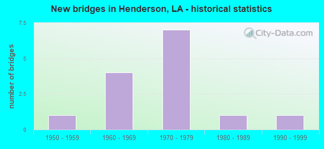
- New bridges - historical statistics
- 11950-1959
- 41960-1969
- 71970-1979
- 11980-1989
- 11990-1999


- Bridge Condition - Deck
- 7.7%Very good
- 15.4%Good
- 61.5%Satisfactory
- 15.4%Fair

- Bridge Condition - Superstructure
- 7.7%Very good
- 46.2%Good
- 38.5%Satisfactory
- 7.7%Fair

- Bridge Condition - Substructure
- 46.2%Good
- 30.8%Satisfactory
- 7.7%Fair
- 15.4%Poor

- Bridge Condition - Channel
- 9.1%Very good
- 54.5%Good
- 36.4%Satisfactory
Find on map >> Show street view
Structure Number: 35000000300242, Location: 4.49 Mi E of LA 347 (Lat: 30.332669, Lng: -91.759200), Route carried "on" structure: Ramp Interstate 10, Year Built: 1991, Status: Open, Structure Length: 3.93m (12.89ft), Average Daily Traffic: 5,660 (year 2016), Truck Traffic: 22%, Design Load: HS 20, Features Intersected: WEST ATCHAFALAYA FLDWAY
Minimum Vertical Clearance: 30+ m (98+ ft), Kilometerpoint: 11.502, Lanes on structure: 1, Owner: State Highway Agency, Approaching Roadway Width: 15.9m (52.2ft), Material/Design: Prestressed concrete, Design/Construction: Stringer/Multi-beam, Number Of Spans In Main Unit: 3, Length of Maximum Span: 13.1m (43.0ft), Curb-To-Curb Width: 15.9m (52.2ft), Out-to-Out Width: 16.7m (54.8ft)
Condition: Deck: Very good, Superstructure: Very good, Substructure: Good, Channel: Very good, Operating Rating: 62.6 metric tons, Method Used To Determine Operating Rating: Load Factor (LF), Inventory Rating: 37.2 metric tons, Method Used To Determine Inventory Rating: Load Factor (LF), Structural Evaluation: Better than present minimum criteria, Deck Geometry: Superior to present desirable criteria, Waterway Adequacy: Equal to present desirable criteria, Approach Roadway Alignment: Equal to present desirable criteria, Designated Inspection Frequency: Every 24 months, Underwater Inspection Frequency: Every 60 months, Inspection Date: September 2020, Underwater Inspection Date: June 2020, Deck Structure Type: Concrete Cast-file-Place
Find on map >> Show street view
Structure Number: 35004500606681, Location: 4.37 Mi E of LA 328 (Lat: 30.312881, Lng: -91.845700), Route carried "on" structure: Interstate 10, Year Built: 1970, Status: Open, Structure Length: 53.52m (175.59ft), Average Daily Traffic: 30,150 (year 2016), Truck Traffic: 28%, Average Future Daily Traffic: 19,800 (year 2036), Design Load: HS 20, Features Intersected: MELVIN DUPUIS ROAD
Minimum Vertical Clearance: 30+ m (98+ ft), Kilometerpoint: 10.680, Lanes on structure: 2, Lanes under structure: 2, Base Highway Network: Yes (Inventory Route: 450-06-1, Subroute: 10), Owner: State Highway Agency, Approaching Roadway Width: 12.2m (40.0ft), Skew: 30 degrees, Material/Design: Prestressed concrete, Design/Construction: Stringer/Multi-beam, Number Of Spans In Main Unit: 23, Length of Maximum Span: 26.2m (86.0ft), Curb-To-Curb Width: 12.2m (40.0ft), Out-to-Out Width: 12.9m (42.3ft)
Condition: Deck: Satisfactory, Superstructure: Good, Substructure: Good, Operating Rating: 85.3 metric tons, Method Used To Determine Operating Rating: Load Factor (LF), Inventory Rating: 35.4 metric tons, Method Used To Determine Inventory Rating: Load Factor (LF), Structural Evaluation: Better than present minimum criteria, Deck Geometry: Better than present minimum criteria, Underclear: Better than present minimum criteria, Approach Roadway Alignment: Equal to present desirable criteria, Designated Inspection Frequency: Every 24 months, Inspection Date: March 2021, Deck Structure Type: Concrete Cast-file-Place, Wearing Surface/Protective System: Wearing Surface: Monolithic Concrete
Find on map >> Show street view
Structure Number: 35004500607331, Location: 5 Mi E of LA 328 (Lat: 30.314789, Lng: -91.835119), Route carried "on" structure: Interstate 10, Year Built: 1968, Status: Open, Structure Length: 0.67m (2.20ft), Average Daily Traffic: 70,531 (year 2019), Truck Traffic: 28%, Average Future Daily Traffic: 77,584 (year 2039), Design Load: HS 20, Features Intersected: DRAIN
Minimum Vertical Clearance: 30+ m (98+ ft), Kilometerpoint: 0.414, Lanes on structure: 4, Base Highway Network: Yes (Inventory Route: 450-06-L, Subroute: 20), Owner: State Highway Agency, Approaching Roadway Width: 47.9m (157.2ft), Skew: 14 degrees, Material/Design: Concrete, Design/Construction: Culvert, Number Of Spans In Main Unit: 2, Length of Maximum Span: 3.0m (9.8ft)
Condition: Channel: Good, Culverts: Satisfactory, Operating Rating: 42.1 metric tons, Method Used To Determine Operating Rating: Load and Resistance Factor Rating (LRFR) rating reported by rating factor(RF) method using HL-93 loadings, Inventory Rating: 32.4 metric tons, Method Used To Determine Inventory Rating: Load and Resistance Factor Rating (LRFR) rating reported by rating factor(RF) method using HL-93 loadings, Structural Evaluation: Equal to present minimum criteria, Waterway Adequacy: Equal to present desirable criteria, Approach Roadway Alignment: Equal to present desirable criteria, Designated Inspection Frequency: Every 24 months, Inspection Date: May 2021, Deck Structure Type: Concrete Cast-file-Place
Find on map >> Show street view
Structure Number: 35004500607491, Location: I-10 OVER LA 347 (Lat: 30.315039, Lng: -91.832700), Route carried "on" structure: Interstate 10, Year Built: 1970, Year Reconstructed: 2021, Status: Open, Structure Length: 29.35m (96.29ft), Average Daily Traffic: 28,300 (year 2016), Truck Traffic: 28%, Average Future Daily Traffic: 18,252 (year 2036), Design Load: HS 20, Features Intersected: I-10 OVER LA 347
Minimum Vertical Clearance: 30+ m (98+ ft), Kilometerpoint: 11.951, Lanes on structure: 2, Lanes under structure: 2, Base Highway Network: Yes (Inventory Route: 450-06-1, Subroute: 10), Owner: State Highway Agency, Approaching Roadway Width: 12.2m (40.0ft), Skew: 10 degrees, Material/Design: Steel continuous, Design/Construction: Girder and Floorbeam System, Number Of Spans In Main Unit: 1, Number Of Approach Spans: 13, Length of Maximum Span: 30.5m (100.1ft), Curb-To-Curb Width: 12.2m (40.0ft), Out-to-Out Width: 13.0m (42.7ft)
Condition: Deck: Good, Superstructure: Good, Substructure: Good, Operating Rating: 58.0 metric tons, Method Used To Determine Operating Rating: Load Factor (LF), Inventory Rating: 35.4 metric tons, Method Used To Determine Inventory Rating: Load Factor (LF), Structural Evaluation: Better than present minimum criteria, Deck Geometry: Better than present minimum criteria, Underclear: Meets minimum limits, Approach Roadway Alignment: Equal to present desirable criteria, Designated Inspection Frequency: Every 24 months, Critical Feature Inspection Frequency: Every 24 months, Inspection Date: May 2021, Critical Feature Inspection Date: May 2021, Deck Structure Type: Concrete Cast-file-Place, Wearing Surface/Protective System: Wearing Surface: Epoxy Overlay
Find on map >> Show street view
Structure Number: 35004500607492, Location: I-10 OVER LA 347 (Lat: 30.315750, Lng: -91.829800), Route carried "on" structure: Interstate 10, Year Built: 1970, Year Reconstructed: 2021, Status: Open, Structure Length: 29.35m (96.29ft), Average Daily Traffic: 28,300 (year 2016), Truck Traffic: 28%, Average Future Daily Traffic: 18,252 (year 2036), Design Load: HS 20, Features Intersected: I-10 OVER LA 347
Minimum Vertical Clearance: 30+ m (98+ ft), Kilometerpoint: 18.546, Lanes on structure: 2, Lanes under structure: 2, Base Highway Network: Yes (Inventory Route: 450-06-2, Subroute: 10), Owner: State Highway Agency, Approaching Roadway Width: 18.3m (60.0ft), Skew: 10 degrees, Material/Design: Steel continuous, Design/Construction: Girder and Floorbeam System, Number Of Spans In Main Unit: 1, Number Of Approach Spans: 13, Length of Maximum Span: 32.9m (107.9ft), Curb-To-Curb Width: 18.3m (60.0ft), Out-to-Out Width: 19.1m (62.7ft)
Condition: Deck: Satisfactory, Superstructure: Good, Substructure: Good, Operating Rating: 58.0 metric tons, Method Used To Determine Operating Rating: Load Factor (LF), Inventory Rating: 35.4 metric tons, Method Used To Determine Inventory Rating: Load Factor (LF), Structural Evaluation: Better than present minimum criteria, Deck Geometry: Superior to present desirable criteria, Underclear: Meets minimum limits, Approach Roadway Alignment: Equal to present desirable criteria, Designated Inspection Frequency: Every 24 months, Critical Feature Inspection Frequency: Every 24 months, Inspection Date: May 2021, Critical Feature Inspection Date: May 2021, Deck Structure Type: Concrete Cast-file-Place
Find on map >> Show street view
Structure Number: 35004500609521, Location: 2.0 MI EAST OF LA 347 (Lat: 30.321731, Lng: -91.800000), Route carried "on" structure: Interstate 10, Year Built: 1970, Year Reconstructed: 2021, Status: Open, Structure Length: 5.55m (18.21ft), Average Daily Traffic: 28,300 (year 2016), Truck Traffic: 22%, Average Future Daily Traffic: 18,252 (year 2036), Design Load: HS 20, Features Intersected: BAYOU PORTAGE
Minimum Vertical Clearance: 30+ m (98+ ft), Kilometerpoint: 15.189, Lanes on structure: 2, Base Highway Network: Yes (Inventory Route: 450-06-1, Subroute: 10), Owner: State Highway Agency, Approaching Roadway Width: 16.5m (54.1ft), Skew: 12 degrees, Material/Design: Prestressed concrete, Design/Construction: Stringer/Multi-beam, Number Of Spans In Main Unit: 3, Length of Maximum Span: 18.3m (60.0ft), Curb-To-Curb Width: 12.2m (40.0ft), Out-to-Out Width: 12.9m (42.3ft)
Condition: Deck: Satisfactory, Superstructure: Good, Substructure: Good, Channel: Satisfactory, Operating Rating: 88.9 metric tons, Method Used To Determine Operating Rating: Load Factor (LF), Inventory Rating: 43.5 metric tons, Method Used To Determine Inventory Rating: Load Factor (LF), Structural Evaluation: Better than present minimum criteria, Deck Geometry: Better than present minimum criteria, Waterway Adequacy: Equal to present desirable criteria, Approach Roadway Alignment: Equal to present desirable criteria, Designated Inspection Frequency: Every 24 months, Underwater Inspection Frequency: Every 60 months, Inspection Date: May 2021, Underwater Inspection Date: July 2018, Deck Structure Type: Concrete Cast-file-Place, Wearing Surface/Protective System: Wearing Surface: Epoxy Overlay
Find on map >> Show street view
Structure Number: 35004500609522, Location: 5.00 Mi W of LA 3177 (Lat: 30.322061, Lng: -91.799400), Route carried "on" structure: Interstate 10, Year Built: 1970, Year Reconstructed: 2021, Status: Open, Structure Length: 5.49m (18.01ft), Average Daily Traffic: 28,300 (year 2016), Truck Traffic: 22%, Average Future Daily Traffic: 18,252 (year 2036), Design Load: HS 20, Features Intersected: BAYOU PORTAGE
Minimum Vertical Clearance: 30+ m (98+ ft), Kilometerpoint: 15.537, Lanes on structure: 2, Base Highway Network: Yes (Inventory Route: 450-06-2, Subroute: 10), Owner: State Highway Agency, Approaching Roadway Width: 18.3m (60.0ft), Skew: 12 degrees, Material/Design: Prestressed concrete, Design/Construction: Stringer/Multi-beam, Number Of Spans In Main Unit: 3, Length of Maximum Span: 18.3m (60.0ft), Curb-To-Curb Width: 15.3m (50.2ft), Out-to-Out Width: 19.2m (63.0ft)
Condition: Deck: Satisfactory, Superstructure: Good, Substructure: Good, Channel: Satisfactory, Operating Rating: 88.9 metric tons, Method Used To Determine Operating Rating: Load Factor (LF), Inventory Rating: 43.5 metric tons, Method Used To Determine Inventory Rating: Load Factor (LF), Structural Evaluation: Better than present minimum criteria, Deck Geometry: Superior to present desirable criteria, Waterway Adequacy: Better than present minimum criteria, Approach Roadway Alignment: Equal to present desirable criteria, Designated Inspection Frequency: Every 24 months, Underwater Inspection Frequency: Every 60 months, Inspection Date: May 2021, Underwater Inspection Date: July 2018, Deck Structure Type: Concrete Cast-file-Place
Find on map >> Show street view
Structure Number: 35004500609931, Location: 2.5 MI EAST OF LA 347 (Lat: 30.323319, Lng: -91.792000), Route carried "on" structure: Interstate 10, Year Built: 1971, Status: Open, Structure Length: 714.45m (2344.00ft), Average Daily Traffic: 28,300 (year 2016), Truck Traffic: 22%, Average Future Daily Traffic: 18,252 (year 2036), Design Load: HS 20, Features Intersected: W ATCHAFALAYA FLOODWAY
Minimum Vertical Clearance: 30+ m (98+ ft), Kilometerpoint: 15.976, Lanes on structure: 2, Lanes under structure: 4, Base Highway Network: Yes (Inventory Route: 450-06-1, Subroute: 10), Owner: State Highway Agency, Approaching Roadway Width: 11.9m (39.0ft), Skew: 10 degrees, Material/Design: Steel continuous, Design/Construction: Girder and Floorbeam System, Number Of Spans In Main Unit: 239, Number Of Approach Spans: 81, Length of Maximum Span: 174.7m (573.2ft), Curb-To-Curb Width: 12.2m (40.0ft), Out-to-Out Width: 13.1m (43.0ft)
Condition: Deck: Satisfactory, Superstructure: Satisfactory, Substructure: Satisfactory, Channel: Good, Operating Rating: 51.7 metric tons, Method Used To Determine Operating Rating: Load Factor (LF), Inventory Rating: 30.8 metric tons, Method Used To Determine Inventory Rating: Load Factor (LF), Structural Evaluation: Equal to present minimum criteria, Deck Geometry: Better than present minimum criteria, Underclear: High priority of corrective action, Waterway Adequacy: Equal to present desirable criteria, Approach Roadway Alignment: Equal to present desirable criteria, Designated Inspection Frequency: Every 24 months, Critical Feature Inspection Frequency: Every 24 months, Underwater Inspection Frequency: Every 60 months, Inspection Date: September 2020, Critical Feature Inspection Date: September 2020, Underwater Inspection Date: September 2018, Deck Structure Type: Concrete Cast-file-Place
Find on map >> Show street view
Structure Number: 35008502805791, Location: 5.7 MI NORTH OF LA 347 (Lat: 30.281261, Lng: -91.824500), Route carried "on" structure: State highway 3039, Year Built: 1961, Status: Posted for load, Structure Length: 2.96m (9.71ft), Average Daily Traffic: 2,200 (year 2016), Truck Traffic: 12%, Average Future Daily Traffic: 1,092 (year 2036), Design Load: H 15, Features Intersected: BAYOU PORTAGE
Minimum Vertical Clearance: 30+ m (98+ ft), Kilometerpoint: 9.325, Lanes on structure: 2, Owner: State Highway Agency, Approaching Roadway Width: 11.0m (36.1ft), Material/Design: Wood or Timber, Design/Construction: Stringer/Multi-beam, Number Of Spans In Main Unit: 5, Length of Maximum Span: 5.8m (19.0ft), Curb-To-Curb Width: 7.7m (25.3ft), Out-to-Out Width: 8.5m (27.9ft)
Condition: Deck: Satisfactory, Superstructure: Satisfactory, Substructure: Fair, Channel: Satisfactory, Operating Rating: 26.0 metric tons, Method Used To Determine Operating Rating: Allowable Stress (AS), Inventory Rating: 18.1 metric tons, Method Used To Determine Inventory Rating: Allowable Stress (AS), Structural Evaluation: Somewhat better than minimum adequacy, Deck Geometry: High priority of replacement, Waterway Adequacy: Better than present minimum criteria, Approach Roadway Alignment: Equal to present minimum criteria, Bridge Posting: Required (Relationship of Operating Rating to Maximum Legal Load: 0.1 - 9.9% below), Designated Inspection Frequency: Every 24 months, Underwater Inspection Frequency: Every 60 months, Inspection Date: August 2020, Underwater Inspection Date: June 2018, Deck Structure Type: Wood or Timber, Wearing Surface/Protective System: Wearing Surface: Bituminous
Find on map >> Show street view
Structure Number: 35030180914821, Location: 0.7 Mi. S of LA 352 (Lat: 30.301739, Lng: -91.803150), Route carried "on" structure: County highway , Year Built: 1955, Status: Posted for load, Structure Length: 1.28m (4.20ft), Average Daily Traffic: 30 (year 1971), Average Future Daily Traffic: 18 (year 2036), Design Load: HS 15, Features Intersected: NICOLE COULEE, Facility Carried by Structure: Roman Robin Rd
Minimum Vertical Clearance: 30+ m (98+ ft), Kilometerpoint: 0.000, Lanes on structure: 2, Owner: County Highway Agency, Approaching Roadway Width: 6.7m (22.0ft), Skew: 4 degrees, Material/Design: Steel, Design/Construction: Stringer/Multi-beam, Number Of Spans In Main Unit: 1, Length of Maximum Span: 12.2m (40.0ft), Curb-To-Curb Width: 5.4m (17.7ft), Out-to-Out Width: 6.1m (20.0ft)
Condition: Deck: Fair, Superstructure: Satisfactory, Substructure: Satisfactory, Channel: Good, Operating Rating: 24.0 metric tons, Method Used To Determine Operating Rating: Load and Resistance Factor Rating (LRFR) rating reported by rating factor(RF) method using HL-93 loadings, Inventory Rating: 18.5 metric tons, Method Used To Determine Inventory Rating: Load and Resistance Factor Rating (LRFR) rating reported by rating factor(RF) method using HL-93 loadings, Structural Evaluation: Somewhat better than minimum adequacy, Deck Geometry: High priority of corrective action, Waterway Adequacy: Equal to present minimum criteria, Approach Roadway Alignment: Equal to present minimum criteria, Bridge Posting: Required (Relationship of Operating Rating to Maximum Legal Load: 20.0 - 29.9% below), Length Of Structure Improvement: 1.95m (6.40ft), Designated Inspection Frequency: Every 24 months, Inspection Date: October 2020, Bridge Improvement Cost: $116,000, Total Project Cost: $174,000 ( Estimate for 2016), Deck Structure Type: Concrete Cast-file-Place
Find on map >> Show street view
Structure Number: 35030186914871, Location: 0.1 Mi. S of LA 352 (Lat: 30.311469, Lng: -91.811489), Route carried "on" structure: County highway , Year Built: 1975, Status: Open, Structure Length: 1.16m (3.81ft), Average Daily Traffic: 220 (year 1971), Average Future Daily Traffic: 132 (year 2036), Design Load: HS 20, Features Intersected: NICOLE COULEE, Facility Carried by Structure: Ches Courville Rd
Minimum Vertical Clearance: 30+ m (98+ ft), Kilometerpoint: 0.000, Lanes on structure: 2, Owner: County Highway Agency, Approaching Roadway Width: 6.1m (20.0ft), Skew: 4 degrees, Material/Design: Concrete, Design/Construction: Slab, Number Of Spans In Main Unit: 2, Length of Maximum Span: 5.8m (19.0ft), Curb-To-Curb Width: 6.1m (20.0ft), Out-to-Out Width: 6.7m (22.0ft)
Condition: Deck: Fair, Superstructure: Fair, Substructure: Poor, Channel: Satisfactory, Operating Rating: 29.2 metric tons, Method Used To Determine Operating Rating: Load and Resistance Factor Rating (LRFR) rating reported by rating factor(RF) method using HL-93 loadings, Inventory Rating: 22.4 metric tons, Method Used To Determine Inventory Rating: Load and Resistance Factor Rating (LRFR) rating reported by rating factor(RF) method using HL-93 loadings, Structural Evaluation: Meets minimum limits, Deck Geometry: Meets minimum limits, Waterway Adequacy: Equal to present minimum criteria, Approach Roadway Alignment: Equal to present desirable criteria, Length Of Structure Improvement: 1.80m (5.91ft), Designated Inspection Frequency: Every 24 months, Other Special Inspection Frequency: Every 12 months, Inspection Date: October 2020, Other Special Inspection Date: October 2021, Bridge Improvement Cost: $107,000, Total Project Cost: $160,000 ( Estimate for 2016), Deck Structure Type: Concrete Cast-file-Place, Wearing Surface/Protective System: Wearing Surface: Bituminous
Find on map >> Show street view
Structure Number: 35030190914821, Location: 0.4 Mi. N of LA 352 (Lat: 30.318111, Lng: -91.802619), Route carried "on" structure: County highway , Year Built: 1967, Status: Posted for load, Structure Length: 1.16m (3.81ft), Average Daily Traffic: 220 (year 1971), Average Future Daily Traffic: 132 (year 2036), Design Load: HS 20, Features Intersected: TRUE CANAL, Facility Carried by Structure: Patin St.
Minimum Vertical Clearance: 30+ m (98+ ft), Kilometerpoint: 0.000, Lanes on structure: 2, Owner: County Highway Agency, Approaching Roadway Width: 6.7m (22.0ft), Material/Design: Concrete, Design/Construction: Slab, Number Of Spans In Main Unit: 2, Length of Maximum Span: 5.8m (19.0ft), Curb-To-Curb Width: 7.3m (24.0ft), Out-to-Out Width: 8.4m (27.6ft)
Condition: Deck: Satisfactory, Superstructure: Satisfactory, Substructure: Satisfactory, Channel: Good, Operating Rating: 23.0 metric tons, Method Used To Determine Operating Rating: Load and Resistance Factor Rating (LRFR) rating reported by rating factor(RF) method using HL-93 loadings, Inventory Rating: 17.8 metric tons, Method Used To Determine Inventory Rating: Load and Resistance Factor Rating (LRFR) rating reported by rating factor(RF) method using HL-93 loadings, Structural Evaluation: Somewhat better than minimum adequacy, Deck Geometry: Somewhat better than minimum adequacy, Waterway Adequacy: Better than present minimum criteria, Approach Roadway Alignment: Equal to present desirable criteria, Bridge Posting: Required (Relationship of Operating Rating to Maximum Legal Load: 0.1 - 9.9% below), Designated Inspection Frequency: Every 24 months, Underwater Inspection Frequency: Every 60 months, Inspection Date: October 2020, Underwater Inspection Date: June 2020, Deck Structure Type: Concrete Cast-file-Place
Find on map >> Show street view
Structure Number: 35030191914801, Location: 0.4 Mi N of LA 352 (Lat: 30.318911, Lng: -91.798561), Route carried "on" structure: County highway , Year Built: 1967, Status: Posted for load, Structure Length: 1.16m (3.81ft), Average Daily Traffic: 420 (year 1971), Average Future Daily Traffic: 252 (year 2036), Design Load: HS 20, Features Intersected: TRUE CANAL, Facility Carried by Structure: Huval St
Minimum Vertical Clearance: 30+ m (98+ ft), Kilometerpoint: 0.000, Lanes on structure: 2, Owner: County Highway Agency, Approaching Roadway Width: 7.3m (24.0ft), Material/Design: Concrete, Design/Construction: Slab, Number Of Spans In Main Unit: 2, Length of Maximum Span: 5.8m (19.0ft), Curb-To-Curb Width: 7.4m (24.3ft), Out-to-Out Width: 8.3m (27.2ft)
Condition: Deck: Satisfactory, Superstructure: Satisfactory, Substructure: Poor, Channel: Good, Operating Rating: 22.0 metric tons, Method Used To Determine Operating Rating: Load and Resistance Factor Rating (LRFR) rating reported by rating factor(RF) method using HL-93 loadings, Inventory Rating: 17.2 metric tons, Method Used To Determine Inventory Rating: Load and Resistance Factor Rating (LRFR) rating reported by rating factor(RF) method using HL-93 loadings, Structural Evaluation: Meets minimum limits, Deck Geometry: Meets minimum limits, Waterway Adequacy: Better than present minimum criteria, Approach Roadway Alignment: Better than present minimum criteria, Bridge Posting: Required (Relationship of Operating Rating to Maximum Legal Load: 0.1 - 9.9% below), Designated Inspection Frequency: Every 24 months, Other Special Inspection Frequency: Every 12 months, Inspection Date: October 2020, Other Special Inspection Date: October 2021, Deck Structure Type: Concrete Precast Panels
Find on map >> Show street view
Structure Number: 35030206914731, Location: 0.8 MI. E. OF HWY LA 678 (Lat: 30.343100, Lng: -91.788081), Route carried "on" structure: County highway , Year Built: 1985, Status: Posted for load, Structure Length: 8.69m (28.51ft), Average Daily Traffic: 150 (year 1985), Average Future Daily Traffic: 90 (year 2036), Design Load: HS 20, Features Intersected: BAYOU BERARD DRAIN CANAL, Facility Carried by Structure: Potato Shed Rd
Minimum Vertical Clearance: 30+ m (98+ ft), Kilometerpoint: 0.000, Lanes on structure: 2, Owner: County Highway Agency, Approaching Roadway Width: 8.5m (27.9ft), Material/Design: Concrete, Design/Construction: Slab, Number Of Spans In Main Unit: 15, Length of Maximum Span: 5.8m (19.0ft), Curb-To-Curb Width: 7.3m (24.0ft), Out-to-Out Width: 8.2m (26.9ft)
Condition: Deck: Good, Superstructure: Good, Substructure: Satisfactory, Channel: Good, Operating Rating: 41.5 metric tons, Method Used To Determine Operating Rating: Load and Resistance Factor Rating (LRFR) rating reported by rating factor(RF) method using HL-93 loadings, Inventory Rating: 32.1 metric tons, Method Used To Determine Inventory Rating: Load and Resistance Factor Rating (LRFR) rating reported by rating factor(RF) method using HL-93 loadings, Structural Evaluation: Equal to present minimum criteria, Deck Geometry: Somewhat better than minimum adequacy, Waterway Adequacy: Equal to present desirable criteria, Approach Roadway Alignment: Better than present minimum criteria, Designated Inspection Frequency: Every 24 months, Underwater Inspection Frequency: Every 60 months, Inspection Date: October 2020, Underwater Inspection Date: June 2018, Deck Structure Type: Concrete Cast-file-Place
Find on map >> Show street view
Structure Number: 35004500607491, Location: 0.1 MI N OF LA 352 (Lat: 30.315200, Lng: -91.831369), Route carried "under" structure: State highway 347, Structure Length: 0. m, Average Daily Traffic: 8,700 (year 2014), Features Intersected: LA 347 UNDER I-10 EB
Minimum Vertical Clearance: 4.57m (14.99ft), Kilometerpoint: 8.330, Lanes on structure: 2, Length of Maximum Span: 0.0m
Find on map >> Show street view
Structure Number: 35004500607492, Location: 0.12 MI N OF LA 352 (Lat: 30.315150, Lng: -91.831189), Route carried "under" structure: State highway 347, Structure Length: 0. m, Average Daily Traffic: 8,700 (year 2014), Features Intersected: LA 347 UNDER I-10 WB
Minimum Vertical Clearance: 4.57m (14.99ft), Kilometerpoint: 8.364, Lanes on structure: 2, Length of Maximum Span: 0.0m