Bridge Statistics for Henefer, Utah (UT)
Condition, Traffic, Stress, Structural Evaluation, Project Costs
- National Bridge Inventory (NBI) Statistics
- 12Number of bridges
- 115ft / 34.8mTotal length
- 54,127Total average daily traffic
- 24,569Total average daily truck traffic
- National Bridge Inventory (NBI) Registered Bridges for Henefer
- No street view available for this location
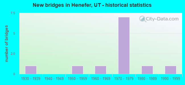
- New bridges - historical statistics
- 11930-1939
- 11950-1959
- 11960-1969
- 71970-1979
- 11980-1989
- 11990-1999


- Bridge Condition - Deck
- 30.0%Good
- 40.0%Satisfactory
- 30.0%Fair

- Bridge Condition - Superstructure
- 30.0%Good
- 50.0%Satisfactory
- 20.0%Fair

- Bridge Condition - Substructure
- 40.0%Good
- 40.0%Satisfactory
- 20.0%Fair

- Bridge Condition - Channel
- 14.3%Very good
- 85.7%Good
Find on map >> Show street view
Structure Number: 29014D, Location: AT DEVILS SLIDE (Lat: 41.060356, Lng: -111.539583), Route carried "on" structure: County highway 1980, Year Built: 1934, Status: Posted for load, Structure Length: 2.97m (9.74ft), Average Daily Traffic: 2,428 (year 2020), Average Future Daily Traffic: 3,035 (year 2040), Design Load: H 15, Features Intersected: WEBER RIVER AND LOST C, Facility Carried by Structure: COUNTY ROAD
Minimum Vertical Clearance: 30+ m (98+ ft), Kilometerpoint: 0.052, Lanes on structure: 2, Owner: County Highway Agency, Approaching Roadway Width: 7.5m (24.6ft), Material/Design: Concrete, Design/Construction: Frame, Number Of Spans In Main Unit: 5, Length of Maximum Span: 5.8m (19.0ft), Curb-To-Curb Width: 7.5m (24.6ft), Out-to-Out Width: 8.1m (26.6ft)
Condition: Deck: Fair, Superstructure: Fair, Substructure: Fair, Channel: Good, Operating Rating: 20.1 metric tons, Method Used To Determine Operating Rating: Load Factor (LF) rating reported by rating factor (RF) method using MS18 loading, Inventory Rating: 13.0 metric tons, Method Used To Determine Inventory Rating: Load Factor (LF) rating reported by rating factor (RF) method using MS18 loading, Structural Evaluation: Meets minimum limits, Deck Geometry: High priority of replacement, Waterway Adequacy: Meets minimum limits, Approach Roadway Alignment: High priority of corrective action, Bridge Posting: Required (Relationship of Operating Rating to Maximum Legal Load: 30.0 - 39.9% below), Designated Inspection Frequency: Every 25 months, Inspection Date: April 2020, Deck Structure Type: Concrete Cast-file-Place, Wearing Surface/Protective System: Wearing Surface: Bituminous
Find on map >> Show street view
Structure Number: 29015D, Location: 1.5 MILES N. DEVILS SLIDE (Lat: 41.070378, Lng: -111.521178), Route carried "on" structure: County highway 1980, Year Built: 1954, Status: Posted for load, Structure Length: 1.97m (6.46ft), Average Daily Traffic: 2,428 (year 2020), Average Future Daily Traffic: 3,035 (year 2040), Design Load: H 15, Features Intersected: LOST CREEK, Facility Carried by Structure: COUNTY ROAD
Minimum Vertical Clearance: 30+ m (98+ ft), Kilometerpoint: 2.272, Lanes on structure: 2, Owner: County Highway Agency, Approaching Roadway Width: 7.3m (24.0ft), Skew: 3 degrees, Material/Design: Concrete, Design/Construction: Frame, Number Of Spans In Main Unit: 1, Length of Maximum Span: 17.6m (57.7ft), Curb or Sidewalk Widths: Left: 0.6m (2.0ft), Right: 0.6m (2.0ft), Curb-To-Curb Width: 7.3m (24.0ft), Out-to-Out Width: 9.2m (30.2ft)
Condition: Deck: Good, Superstructure: Good, Substructure: Good, Channel: Good, Operating Rating: 21.7 metric tons, Method Used To Determine Operating Rating: Load and Resistance Factor Rating (LRFR) rating reported by rating factor(RF) method using HL-93 loadings, Inventory Rating: 13.6 metric tons, Method Used To Determine Inventory Rating: Load and Resistance Factor Rating (LRFR) rating reported by rating factor(RF) method using HL-93 loadings, Structural Evaluation: Meets minimum limits, Deck Geometry: High priority of replacement, Waterway Adequacy: Better than present minimum criteria, Approach Roadway Alignment: Equal to present desirable criteria, Bridge Posting: Required (Relationship of Operating Rating to Maximum Legal Load: 30.0 - 39.9% below), Designated Inspection Frequency: Every 25 months, Inspection Date: April 2020, Deck Structure Type: Concrete Cast-file-Place, Wearing Surface/Protective System: Wearing Surface: Bituminous
Find on map >> Show street view
Structure Number: 43035C, Location: ADJ.TO E.HENEFER,I-84 INT (Lat: 41.016275, Lng: -111.489086), Route carried "on" structure: City street 2612, Year Built: 1997, Status: Open, Structure Length: 4.35m (14.27ft), Average Daily Traffic: 190 (year 2020), Truck Traffic: 10%, Average Future Daily Traffic: 238 (year 2040), Design Load: HS 20+Mod, Features Intersected: UNION PACIFIC RAILROAD, Facility Carried by Structure: HENEFER TOWN ROAD
Minimum Vertical Clearance: 30+ m (98+ ft), Kilometerpoint: 0.000, Lanes on structure: 2, Owner: Town or Township Highway Agency, Approaching Roadway Width: 12.2m (40.0ft), Material/Design: Steel, Design/Construction: Stringer/Multi-beam, Number Of Spans In Main Unit: 1, Length of Maximum Span: 42.6m (139.8ft), Curb-To-Curb Width: 12.2m (40.0ft), Out-to-Out Width: 13.2m (43.3ft)
Condition: Deck: Good, Superstructure: Good, Substructure: Good, Operating Rating: 55.7 metric tons, Method Used To Determine Operating Rating: Load and Resistance Factor Rating (LRFR) rating reported by rating factor(RF) method using HL-93 loadings, Inventory Rating: 46.7 metric tons, Method Used To Determine Inventory Rating: Load Factor (LF) rating reported by rating factor (RF) method using MS18 loading, Structural Evaluation: Better than present minimum criteria, Deck Geometry: Superior to present desirable criteria, Underclear: Superior to present desirable criteria, Approach Roadway Alignment: Equal to present desirable criteria, Designated Inspection Frequency: Every 25 months, Inspection Date: May 2020, Deck Structure Type: Concrete Cast-file-Place, Wearing Surface/Protective System: Wearing Surface: Bituminous, Membrane: Built-up, Deck Protection: Epoxy Coated Reinforcing
Find on map >> Show street view
Structure Number: 43041F, Location: NORTHEAST SIDE OF HENEFER (Lat: 41.018100, Lng: -111.495342), Route carried "on" structure: City street , Year Built: 1989, Status: Open, Structure Length: 2.28m (7.48ft), Average Daily Traffic: 233 (year 2020), Truck Traffic: 1%, Average Future Daily Traffic: 283 (year 2040), Design Load: HS 20+Mod, Features Intersected: WEBER RIVER, Facility Carried by Structure: CENTER ST, HENEFER
Minimum Vertical Clearance: 30+ m (98+ ft), Kilometerpoint: 0.282, Lanes on structure: 2, Owner: Town or Township Highway Agency, Approaching Roadway Width: 9.1m (29.9ft), Material/Design: Prestressed concrete, Design/Construction: Stringer/Multi-beam, Number Of Spans In Main Unit: 1, Length of Maximum Span: 22.0m (72.2ft), Curb-To-Curb Width: 9.1m (29.9ft), Out-to-Out Width: 10.1m (33.1ft)
Condition: Deck: Good, Superstructure: Good, Substructure: Satisfactory, Channel: Good, Operating Rating: 55.4 metric tons, Method Used To Determine Operating Rating: Load and Resistance Factor Rating (LRFR) rating reported by rating factor(RF) method using HL-93 loadings, Inventory Rating: 33.4 metric tons, Method Used To Determine Inventory Rating: Load Factor (LF) rating reported by rating factor (RF) method using MS18 loading, Structural Evaluation: Equal to present minimum criteria, Deck Geometry: Equal to present minimum criteria, Waterway Adequacy: Better than present minimum criteria, Approach Roadway Alignment: Equal to present desirable criteria, Designated Inspection Frequency: Every 25 months, Inspection Date: May 2020, Deck Structure Type: Concrete Cast-file-Place, Wearing Surface/Protective System: Wearing Surface: Monolithic Concrete
Find on map >> Show street view
Structure Number: C 603, Location: 0.3 MI.W.DEVILS SLIDE INT (Lat: 41.063544, Lng: -111.546817), Route carried "on" structure: Interstate 84, Year Built: 1973, Status: Open, Structure Length: 4.22m (13.85ft), Average Daily Traffic: 10,313 (year 2020), Truck Traffic: 53%, Average Future Daily Traffic: 12,891 (year 2040), Design Load: HS 20+Mod, Features Intersected: WEBER RIVER
Minimum Vertical Clearance: 30+ m (98+ ft), Kilometerpoint: 178.661, Lanes on structure: 6, Base Highway Network: Yes, Owner: State Highway Agency, Approaching Roadway Width: 34.4m (112.9ft), Skew: 32 degrees, Material/Design: Steel, Design/Construction: Stringer/Multi-beam, Number Of Spans In Main Unit: 1, Length of Maximum Span: 40.8m (133.9ft), Curb-To-Curb Width: 34.4m (112.9ft), Out-to-Out Width: 37.7m (123.7ft)
Condition: Deck: Satisfactory, Superstructure: Satisfactory, Substructure: Satisfactory, Channel: Very good, Operating Rating: 40.8 metric tons, Method Used To Determine Operating Rating: Load and Resistance Factor Rating (LRFR) rating reported by rating factor(RF) method using HL-93 loadings, Inventory Rating: 27.5 metric tons, Method Used To Determine Inventory Rating: Load and Resistance Factor Rating (LRFR) rating reported by rating factor(RF) method using HL-93 loadings, Structural Evaluation: Equal to present minimum criteria, Deck Geometry: Superior to present desirable criteria, Waterway Adequacy: Equal to present desirable criteria, Approach Roadway Alignment: Equal to present desirable criteria, Designated Inspection Frequency: Every 24 months, Inspection Date: July 2021, Deck Structure Type: Concrete Cast-file-Place, Wearing Surface/Protective System: Wearing Surface: Bituminous, Membrane: Preformed Fabric
Find on map >> Show street view
Structure Number: D 772, Location: 0.25 MI EAST OF HENEFER (Lat: 41.015197, Lng: -111.491894), Route carried "on" structure: State highway 65, Year Built: 1968, Status: Open, Structure Length: 4.55m (14.93ft), Average Daily Traffic: 1,646 (year 2020), Truck Traffic: 21%, Average Future Daily Traffic: 2,058 (year 2040), Design Load: HS 20+Mod, Features Intersected: WEBER RIVER
Minimum Vertical Clearance: 30+ m (98+ ft), Kilometerpoint: 45.144, Lanes on structure: 2, Owner: State Highway Agency, Approaching Roadway Width: 9.2m (30.2ft), Skew: 2 degrees, Material/Design: Concrete, Design/Construction: Tee Beam, Number Of Spans In Main Unit: 3, Length of Maximum Span: 19.2m (63.0ft), Curb-To-Curb Width: 9.2m (30.2ft), Out-to-Out Width: 10.4m (34.1ft)
Condition: Deck: Fair, Superstructure: Fair, Substructure: Fair, Channel: Good, Operating Rating: 33.4 metric tons, Method Used To Determine Operating Rating: Load and Resistance Factor Rating (LRFR) rating reported by rating factor(RF) method using HL-93 loadings, Inventory Rating: 27.2 metric tons, Method Used To Determine Inventory Rating: Load Factor (LF) rating reported by rating factor (RF) method using MS18 loading, Structural Evaluation: Somewhat better than minimum adequacy, Deck Geometry: Somewhat better than minimum adequacy, Waterway Adequacy: Equal to present desirable criteria, Approach Roadway Alignment: Equal to present minimum criteria, Designated Inspection Frequency: Every 26 months, Inspection Date: June 2020, Deck Structure Type: Concrete Cast-file-Place, Wearing Surface/Protective System: Wearing Surface: Bituminous
Find on map >> Show street view
Structure Number: F 262, Location: DEVILS SLIDE INTERCHANGE (Lat: 41.059189, Lng: -111.540422), Route carried "on" structure: Interstate 84, Year Built: 1973, Status: Open, Structure Length: 3.32m (10.89ft), Average Daily Traffic: 10,313 (year 2020), Truck Traffic: 53%, Average Future Daily Traffic: 12,891 (year 2040), Design Load: HS 20+Mod, Features Intersected: CO. ROAD TO DEVILS SLIDE
Minimum Vertical Clearance: 30+ m (98+ ft), Kilometerpoint: 179.384, Lanes on structure: 4, Lanes under structure: 2, Base Highway Network: Yes, Owner: State Highway Agency, Approaching Roadway Width: 27.6m (90.6ft), Skew: 32 degrees, Material/Design: Prestressed concrete, Design/Construction: Stringer/Multi-beam, Number Of Spans In Main Unit: 1, Length of Maximum Span: 31.5m (103.3ft), Curb-To-Curb Width: 27.6m (90.6ft), Out-to-Out Width: 28.6m (93.8ft)
Condition: Deck: Satisfactory, Superstructure: Satisfactory, Substructure: Good, Operating Rating: 34.0 metric tons, Method Used To Determine Operating Rating: Load and Resistance Factor Rating (LRFR) rating reported by rating factor(RF) method using HL-93 loadings, Inventory Rating: 20.4 metric tons, Method Used To Determine Inventory Rating: Load Factor (LF) rating reported by rating factor (RF) method using MS18 loading, Structural Evaluation: Somewhat better than minimum adequacy, Deck Geometry: Superior to present desirable criteria, Underclear: Meets minimum limits, Approach Roadway Alignment: Equal to present desirable criteria, Designated Inspection Frequency: Every 24 months, Inspection Date: July 2021, Deck Structure Type: Concrete Cast-file-Place, Wearing Surface/Protective System: Wearing Surface: Bituminous, Membrane: Preformed Fabric
Find on map >> Show street view
Structure Number: F 292, Location: WEST HENEFER INTERCHANGE (Lat: 41.044464, Lng: -111.523564), Route carried "on" structure: Interstate 84, Year Built: 1973, Status: Open, Structure Length: 3.45m (11.32ft), Average Daily Traffic: 9,556 (year 2020), Truck Traffic: 52%, Average Future Daily Traffic: 11,945 (year 2040), Design Load: HS 20+Mod, Features Intersected: SR-86, INT. X-ROAD
Minimum Vertical Clearance: 30+ m (98+ ft), Kilometerpoint: 181.693, Lanes on structure: 4, Lanes under structure: 2, Base Highway Network: Yes, Owner: State Highway Agency, Approaching Roadway Width: 27.6m (90.6ft), Skew: 30 degrees, Material/Design: Prestressed concrete, Design/Construction: Stringer/Multi-beam, Number Of Spans In Main Unit: 1, Length of Maximum Span: 33.3m (109.3ft), Curb-To-Curb Width: 27.6m (90.6ft), Out-to-Out Width: 29.7m (97.4ft)
Condition: Deck: Satisfactory, Superstructure: Satisfactory, Substructure: Good, Operating Rating: 32.7 metric tons, Method Used To Determine Operating Rating: Load and Resistance Factor Rating (LRFR) rating reported by rating factor(RF) method using HL-93 loadings, Inventory Rating: 21.1 metric tons, Method Used To Determine Inventory Rating: Load Factor (LF) rating reported by rating factor (RF) method using MS18 loading, Structural Evaluation: Somewhat better than minimum adequacy, Deck Geometry: Superior to present desirable criteria, Underclear: Equal to present minimum criteria, Approach Roadway Alignment: Equal to present desirable criteria, Designated Inspection Frequency: Every 26 months, Inspection Date: June 2020, Deck Structure Type: Concrete Cast-file-Place, Wearing Surface/Protective System: Wearing Surface: Bituminous, Membrane: Preformed Fabric
Find on map >> Show street view
Structure Number: 2F 201, Location: NORTHWEST OF HENEFER (Lat: 41.035806, Lng: -111.510303), Route carried "on" structure: Interstate 84, Year Built: 1971, Status: Open, Structure Length: 3.84m (12.60ft), Average Daily Traffic: 8,224 (year 2020), Truck Traffic: 50%, Average Future Daily Traffic: 10,280 (year 2040), Design Load: HS 20+Mod, Features Intersected: WEBER RIVER
Minimum Vertical Clearance: 30+ m (98+ ft), Kilometerpoint: 182.900, Lanes on structure: 2, Base Highway Network: Yes, Owner: State Highway Agency, Approaching Roadway Width: 11.5m (37.7ft), Material/Design: Prestressed concrete, Design/Construction: Stringer/Multi-beam, Number Of Spans In Main Unit: 2, Length of Maximum Span: 18.6m (61.0ft), Curb-To-Curb Width: 11.5m (37.7ft), Out-to-Out Width: 12.5m (41.0ft)
Condition: Deck: Fair, Superstructure: Satisfactory, Substructure: Satisfactory, Channel: Good, Operating Rating: 35.6 metric tons, Method Used To Determine Operating Rating: Load and Resistance Factor Rating (LRFR) rating reported by rating factor(RF) method using HL-93 loadings, Inventory Rating: 22.7 metric tons, Method Used To Determine Inventory Rating: Load Factor (LF) rating reported by rating factor (RF) method using MS18 loading, Structural Evaluation: Somewhat better than minimum adequacy, Deck Geometry: Somewhat better than minimum adequacy, Waterway Adequacy: Equal to present minimum criteria, Approach Roadway Alignment: Equal to present desirable criteria, Designated Inspection Frequency: Every 24 months, Underwater Inspection Frequency: Every 60 months, Inspection Date: June 2020, Underwater Inspection Date: August 2019, Deck Structure Type: Concrete Cast-file-Place, Wearing Surface/Protective System: Wearing Surface: Bituminous, Membrane: Preformed Fabric
Find on map >> Show street view
Structure Number: 4F 201, Location: NORTHWEST OF HENEFER (Lat: 41.035775, Lng: -111.509611), Route carried "on" structure: Interstate 84, Year Built: 1971, Status: Open, Structure Length: 3.84m (12.60ft), Average Daily Traffic: 8,224 (year 2020), Truck Traffic: 50%, Average Future Daily Traffic: 10,280 (year 2040), Design Load: HS 20+Mod, Features Intersected: WEBER RIVER
Minimum Vertical Clearance: 30+ m (98+ ft), Kilometerpoint: 183.037, Lanes on structure: 2, Base Highway Network: Yes, Owner: State Highway Agency, Approaching Roadway Width: 10.6m (34.8ft), Skew: 10 degrees, Material/Design: Prestressed concrete, Design/Construction: Stringer/Multi-beam, Number Of Spans In Main Unit: 2, Length of Maximum Span: 18.4m (60.4ft), Curb-To-Curb Width: 11.5m (37.7ft), Out-to-Out Width: 12.6m (41.3ft)
Condition: Deck: Satisfactory, Superstructure: Satisfactory, Substructure: Satisfactory, Channel: Good, Operating Rating: 38.2 metric tons, Method Used To Determine Operating Rating: Load and Resistance Factor Rating (LRFR) rating reported by rating factor(RF) method using HL-93 loadings, Inventory Rating: 22.7 metric tons, Method Used To Determine Inventory Rating: Load Factor (LF) rating reported by rating factor (RF) method using MS18 loading, Structural Evaluation: Somewhat better than minimum adequacy, Deck Geometry: Somewhat better than minimum adequacy, Waterway Adequacy: Equal to present minimum criteria, Approach Roadway Alignment: Equal to present desirable criteria, Designated Inspection Frequency: Every 26 months, Underwater Inspection Frequency: Every 60 months, Inspection Date: June 2020, Underwater Inspection Date: August 2019, Deck Structure Type: Concrete Cast-file-Place, Wearing Surface/Protective System: Wearing Surface: Bituminous, Membrane: Preformed Fabric
Find on map >> Show street view
Structure Number: F 262, Location: DEVILS SLIDE INTERCHANGE (Lat: 41.059189, Lng: -111.540422), Route carried "under" structure: County highway , Year Built: 1973, Structure Length: 0. m, Features Intersected: CO. ROAD TO DEVILS SLIDE, Facility Carried by Structure: I-84 (SR-84)
Minimum Vertical Clearance: 4.82m (15.81ft), Kilometerpoint: 0.000, Lanes on structure: 4, Lanes under structure: 2, Material/Design: Prestressed concrete, Design/Construction: Stringer/Multi-beam, Length of Maximum Span: 31.5m (103.3ft)
Find on map >> Show street view
Structure Number: F 292, Location: WEST HENEFER INTERCHANGE (Lat: 41.044464, Lng: -111.523564), Route carried "under" structure: State highway 86, Year Built: 1973, Structure Length: 0. m, Average Daily Traffic: 572 (year 2020), Truck Traffic: 14%, Features Intersected: SR-86, INT. X-ROAD, Facility Carried by Structure: I-84 (SR-84)
Minimum Vertical Clearance: 4.62m (15.16ft), Kilometerpoint: 0.064, Lanes on structure: 4, Lanes under structure: 2, Material/Design: Prestressed concrete, Design/Construction: Stringer/Multi-beam, Length of Maximum Span: 33.3m (109.3ft)