Bridge Statistics for Herkimer, New York (NY)
Condition, Traffic, Stress, Structural Evaluation, Project Costs
- National Bridge Inventory (NBI) Statistics
- 23Number of bridges
- 256ft / 78.1mTotal length
- $56,775,000Total costs
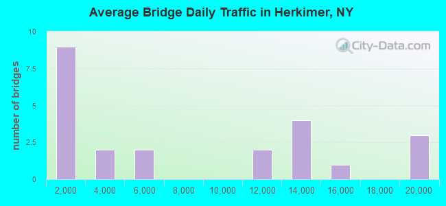
- 164,086Total average daily traffic
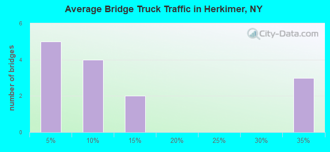
- 20,648Total average daily truck traffic
- National Bridge Inventory (NBI) Registered Bridges for Herkimer
- No street view available for this location
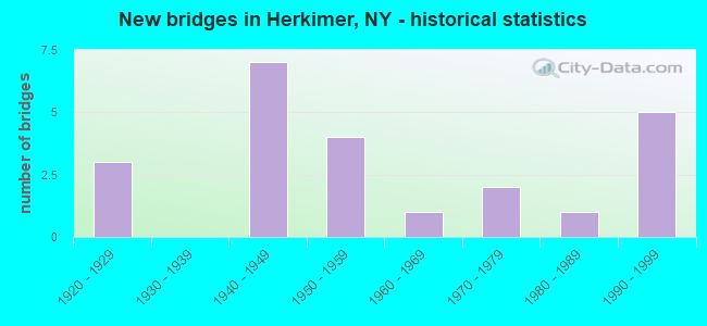
- New bridges - historical statistics
- 31920-1929
- 71940-1949
- 41950-1959
- 11960-1969
- 21970-1979
- 11980-1989
- 51990-1999
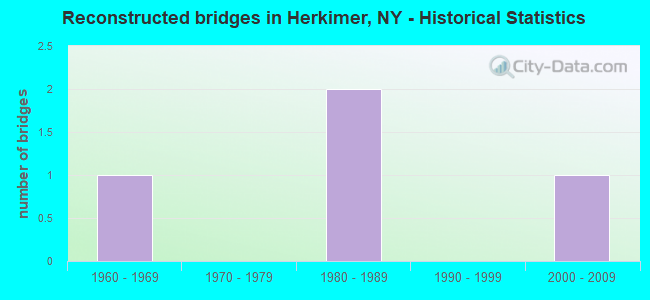
- Reconstructed bridges - Historical Statistics
- 11960-1969
- 01970-1979
- 21980-1989
- 01990-1999
- 12000-2009
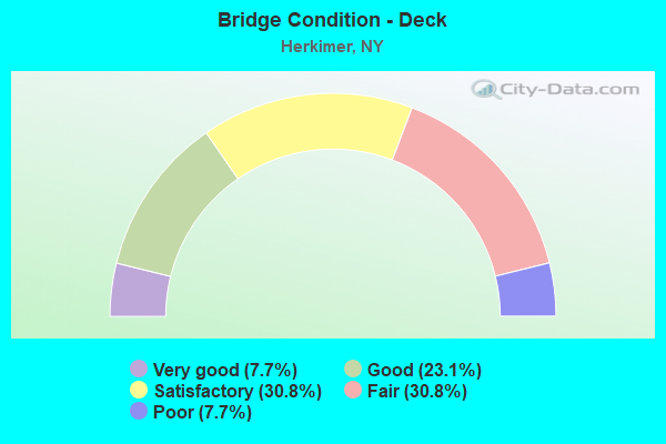
- Bridge Condition - Deck
- 7.7%Very good
- 23.1%Good
- 30.8%Satisfactory
- 30.8%Fair
- 7.7%Poor
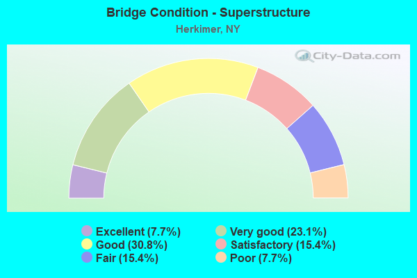
- Bridge Condition - Superstructure
- 7.7%Excellent
- 23.1%Very good
- 30.8%Good
- 15.4%Satisfactory
- 15.4%Fair
- 7.7%Poor
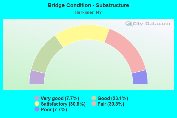
- Bridge Condition - Substructure
- 7.7%Very good
- 23.1%Good
- 30.8%Satisfactory
- 30.8%Fair
- 7.7%Poor
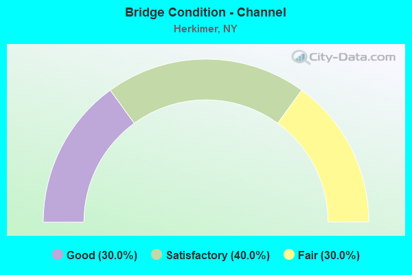
- Bridge Condition - Channel
- 30.0%Good
- 40.0%Satisfactory
- 30.0%Fair
Find on map >> Show street view
Structure Number: 1002429, Location: 1.7 MI E JCT RTS 5 & 51 (Lat: 43.020100, Lng: -75.000469), Route carried "on" structure: State highway 5, Year Built: 1949, Year Reconstructed: 1992, Status: Open, Structure Length: 2.29m (7.51ft), Average Daily Traffic: 13,020 (year 2013), Truck Traffic: 5%, Average Future Daily Traffic: 13,081 (year 2040), Design Load: HS 20, Features Intersected: CSX TRANSPRTATION
Minimum Vertical Clearance: 30+ m (98+ ft), Kilometerpoint: 17.442, Lanes on structure: 4, Base Highway Network: Yes, Owner: State Highway Agency, Approaching Roadway Width: 17.7m (58.1ft), Skew: 26 degrees, Material/Design: Steel, Design/Construction: Stringer/Multi-beam, Number Of Spans In Main Unit: 1, Length of Maximum Span: 20.4m (66.9ft), Curb-To-Curb Width: 17.7m (58.1ft), Out-to-Out Width: 19.3m (63.3ft)
Condition: Deck: Good, Superstructure: Very good, Substructure: Satisfactory, Operating Rating: 99.8 metric tons, Method Used To Determine Operating Rating: Load Factor (LF), Inventory Rating: 59.0 metric tons, Method Used To Determine Inventory Rating: Load Factor (LF), Structural Evaluation: Equal to present minimum criteria, Deck Geometry: Somewhat better than minimum adequacy, Approach Roadway Alignment: Equal to present desirable criteria, Length Of Structure Improvement: 2.28m (7.48ft), Designated Inspection Frequency: Every 24 months, Inspection Date: November 2020, Bridge Improvement Cost: $2,666,000, Roadway Improvement Cost: $1,561,000, Total Project Cost: $4,227,000 ( Estimate for 2021), Deck Structure Type: Concrete Cast-file-Place, Wearing Surface/Protective System: Wearing Surface: Integral Concrete, Deck Protection: Epoxy Coated Reinforcing
Find on map >> Show street view
Structure Number: 100243, Location: .1 MI W JCT SH 5 & SH 28 (Lat: 43.026561, Lng: -74.983122), Route carried "on" structure: State highway 5, Year Built: 1949, Status: Open, Structure Length: 1.46m (4.79ft), Average Daily Traffic: 15,055 (year 2020), Truck Traffic: 5%, Average Future Daily Traffic: 15,125 (year 2040), Design Load: HS 20, Features Intersected: HYDRAULIC CANAL
Minimum Vertical Clearance: 30+ m (98+ ft), Kilometerpoint: 19.083, Lanes on structure: 6, Base Highway Network: Yes, Owner: State Highway Agency, Approaching Roadway Width: 18.9m (62.0ft), Skew: 20 degrees, Material/Design: Steel, Design/Construction: Stringer/Multi-beam, Number Of Spans In Main Unit: 1, Length of Maximum Span: 13.4m (44.0ft), Curb or Sidewalk Widths: Left: 1.5m (4.9ft), Right: 1.5m (4.9ft), Curb-To-Curb Width: 27.9m (91.5ft), Out-to-Out Width: 31.6m (103.7ft)
Condition: Deck: Fair, Superstructure: Good, Substructure: Fair, Channel: Good, Operating Rating: 67.4 metric tons, Method Used To Determine Operating Rating: Load and Resistance Factor Rating (LRFR) rating reported by rating factor(RF) method using HL-93 loadings, Inventory Rating: 51.8 metric tons, Method Used To Determine Inventory Rating: Load and Resistance Factor Rating (LRFR) rating reported by rating factor(RF) method using HL-93 loadings, Structural Evaluation: Somewhat better than minimum adequacy, Deck Geometry: Superior to present desirable criteria, Waterway Adequacy: Equal to present minimum criteria, Approach Roadway Alignment: Equal to present desirable criteria, Length Of Structure Improvement: 1.46m (4.79ft), Designated Inspection Frequency: Every 24 months, Inspection Date: July 2020, Bridge Improvement Cost: $1,227,000, Roadway Improvement Cost: $718,000, Total Project Cost: $1,945,000 ( Estimate for 2021), Deck Structure Type: Concrete Cast-file-Place, Wearing Surface/Protective System: Wearing Surface: Bituminous
Find on map >> Show street view
Structure Number: 100244, Location: .3 MI W JCT SH 5 & SH 28 (Lat: 43.029181, Lng: -74.974922), Route carried "on" structure: State highway 5, Year Built: 1997, Status: Open, Structure Length: 18.14m (59.51ft), Average Daily Traffic: 11,195 (year 2020), Truck Traffic: 5%, Average Future Daily Traffic: 11,247 (year 2040), Design Load: HS 25 or greater, Features Intersected: WEST CANADA CREEK
Minimum Vertical Clearance: 30+ m (98+ ft), Kilometerpoint: 19.791, Lanes on structure: 4, Base Highway Network: Yes, Owner: State Highway Agency, Approaching Roadway Width: 15.8m (51.8ft), Skew: 21 degrees, Material/Design: Steel continuous, Design/Construction: Stringer/Multi-beam, Number Of Spans In Main Unit: 4, Length of Maximum Span: 49.9m (163.7ft), Curb or Sidewalk Widths: Left: 1.5m (4.9ft), Right: 0.0m, Curb-To-Curb Width: 20.7m (67.9ft), Out-to-Out Width: 23.0m (75.5ft)
Condition: Deck: Satisfactory, Superstructure: Very good, Substructure: Good, Channel: Good, Operating Rating: 76.2 metric tons, Method Used To Determine Operating Rating: Load Factor (LF), Inventory Rating: 45.4 metric tons, Method Used To Determine Inventory Rating: Load Factor (LF), Structural Evaluation: Better than present minimum criteria, Deck Geometry: Superior to present desirable criteria, Waterway Adequacy: Somewhat better than minimum adequacy, Approach Roadway Alignment: Equal to present desirable criteria, Length Of Structure Improvement: 18.13m (59.48ft), Designated Inspection Frequency: Every 24 months, Inspection Date: June 2021, Bridge Improvement Cost: $6,562,000, Roadway Improvement Cost: $3,842,000, Total Project Cost: $10,404,000 ( Estimate for 2021), Deck Structure Type: Concrete Cast-file-Place, Wearing Surface/Protective System: Wearing Surface: Integral Concrete, Deck Protection: Epoxy Coated Reinforcing
Find on map >> Show street view
Structure Number: 1020079, Location: MOHAWK ST RT 28 (Lat: 43.017522, Lng: -74.993569), Route carried "on" structure: Interstate 90, Year Built: 1954, Status: Open, Structure Length: 3.96m (12.99ft), Average Daily Traffic: 19,222 (year 2020), Truck Traffic: 32%, Average Future Daily Traffic: 22,147 (year 2040), Design Load: HS 20, Features Intersected: NYS Route 28 SB, RTE 28
Minimum Vertical Clearance: 30+ m (98+ ft), Kilometerpoint: 17.812, Lanes on structure: 4, Lanes under structure: 5, Base Highway Network: Yes, Toll: On Interstate toll segment, Owner: State Toll Authority, Approaching Roadway Width: 39.6m (129.9ft), Skew: 33 degrees, Material/Design: Steel, Design/Construction: Stringer/Multi-beam, Number Of Spans In Main Unit: 2, Length of Maximum Span: 18.9m (62.0ft), Curb-To-Curb Width: 39.5m (129.6ft), Out-to-Out Width: 40.6m (133.2ft)
Condition: Deck: Fair, Superstructure: Fair, Substructure: Poor, Operating Rating: 52.6 metric tons, Method Used To Determine Operating Rating: Load Factor (LF), Inventory Rating: 31.8 metric tons, Method Used To Determine Inventory Rating: Load Factor (LF), Structural Evaluation: Meets minimum limits, Deck Geometry: Superior to present desirable criteria, Underclear: High priority of corrective action, Approach Roadway Alignment: Equal to present desirable criteria, Length Of Structure Improvement: 3.96m (12.99ft), Designated Inspection Frequency: Every 24 months, Inspection Date: August 2020, Bridge Improvement Cost: $3,855,000, Roadway Improvement Cost: $2,258,000, Total Project Cost: $6,113,000 ( Estimate for 2021), Deck Structure Type: Concrete Cast-file-Place, Wearing Surface/Protective System: Wearing Surface: Bituminous, Membrane: Other
Find on map >> Show street view
Structure Number: 102009, Location: 15 MI N JCT RTS 5 & 28 (Lat: 43.049256, Lng: -74.985767), Route carried "on" structure: State highway 28, Year Built: 1964, Status: Open, Structure Length: 1.65m (5.41ft), Average Daily Traffic: 4,000 (year 2018), Truck Traffic: 13%, Average Future Daily Traffic: 4,024 (year 2040), Design Load: HS 20, Features Intersected: HYDRAULIC CANAL
Minimum Vertical Clearance: 30+ m (98+ ft), Kilometerpoint: 22.751, Lanes on structure: 2, Base Highway Network: Yes, Owner: State Highway Agency, Approaching Roadway Width: 12.2m (40.0ft), Skew: 4 degrees, Material/Design: Steel, Design/Construction: Culvert, Number Of Spans In Main Unit: 2, Length of Maximum Span: 6.7m (22.0ft)
Condition: Channel: Fair, Culverts: Satisfactory, Operating Rating: 76.8 metric tons, Method Used To Determine Operating Rating: Field evaluation and documented engineering judgment, Inventory Rating: 29.4 metric tons, Method Used To Determine Inventory Rating: Field evaluation and documented engineering judgment, Structural Evaluation: Equal to present minimum criteria, Waterway Adequacy: Superior to present desirable criteria, Approach Roadway Alignment: Equal to present desirable criteria, Length Of Structure Improvement: 1.64m (5.38ft), Designated Inspection Frequency: Every 24 months, Inspection Date: June 2021, Bridge Improvement Cost: $289,000, Roadway Improvement Cost: $169,000, Total Project Cost: $458,000 ( Estimate for 2021)
Find on map >> Show street view
Structure Number: 220462, Location: .75 MI N JCT SH 5 & SH 28 (Lat: 43.049044, Lng: -74.985200), Route carried "on" structure: County highway , Year Built: 1989, Status: Open, Structure Length: 10.52m (34.51ft), Average Daily Traffic: 667 (year 2017), Truck Traffic: 6%, Average Future Daily Traffic: 934 (year 2037), Design Load: HS 20, Features Intersected: WEST CANADA CREEK, Facility Carried by Structure: SHELLS BUSH ROAD
Minimum Vertical Clearance: 30+ m (98+ ft), Kilometerpoint: 0.000, Lanes on structure: 2, Owner: Town or Township Highway Agency, Approaching Roadway Width: 7.0m (23.0ft), Skew: 1 degrees, Material/Design: Steel continuous, Design/Construction: Stringer/Multi-beam, Number Of Spans In Main Unit: 3, Length of Maximum Span: 42.0m (137.8ft), Curb-To-Curb Width: 7.0m (23.0ft), Out-to-Out Width: 7.6m (24.9ft)
Condition: Deck: Satisfactory, Superstructure: Satisfactory, Substructure: Good, Channel: Satisfactory, Operating Rating: 94.7 metric tons, Method Used To Determine Operating Rating: Field evaluation and documented engineering judgment, Inventory Rating: 32.7 metric tons, Method Used To Determine Inventory Rating: Field evaluation and documented engineering judgment, Structural Evaluation: Equal to present minimum criteria, Deck Geometry: Meets minimum limits, Waterway Adequacy: Somewhat better than minimum adequacy, Approach Roadway Alignment: Equal to present desirable criteria, Length Of Structure Improvement: 10.51m (34.48ft), Designated Inspection Frequency: Every 24 months, Inspection Date: July 2021, Bridge Improvement Cost: $1,298,000, Roadway Improvement Cost: $760,000, Total Project Cost: $2,058,000 ( Estimate for 2021), Deck Structure Type: Concrete Cast-file-Place, Wearing Surface/Protective System: Wearing Surface: Integral Concrete, Deck Protection: Epoxy Coated Reinforcing
Find on map >> Show street view
Structure Number: 220463, Location: 1 MILE NE OF KAST BRIDGE (Lat: 43.075761, Lng: -74.972336), Route carried "on" structure: Other road , Year Built: 1970, Status: Posted for load, Structure Length: 1.92m (6.30ft), Average Daily Traffic: 93 (year 2017), Truck Traffic: 4%, Average Future Daily Traffic: 130 (year 2037), Design Load: HS 15, Features Intersected: NORTH CREEK, Facility Carried by Structure: FIDDLETOWN ROAD
Minimum Vertical Clearance: 30+ m (98+ ft), Kilometerpoint: 2.188, Lanes on structure: 2, Owner: Town or Township Highway Agency, Approaching Roadway Width: 4.9m (16.1ft), Material/Design: Steel, Design/Construction: Stringer/Multi-beam, Number Of Spans In Main Unit: 1, Length of Maximum Span: 17.9m (58.7ft), Curb-To-Curb Width: 6.1m (20.0ft), Out-to-Out Width: 6.4m (21.0ft)
Condition: Deck: Fair, Superstructure: Fair, Substructure: Satisfactory, Channel: Good, Operating Rating: 52.6 metric tons, Method Used To Determine Operating Rating: Load Factor (LF), Inventory Rating: 31.8 metric tons, Method Used To Determine Inventory Rating: Load Factor (LF), Structural Evaluation: Somewhat better than minimum adequacy, Deck Geometry: Somewhat better than minimum adequacy, Waterway Adequacy: Meets minimum limits, Approach Roadway Alignment: Meets minimum limits, Bridge Posting: Required (Relationship of Operating Rating to Maximum Legal Load: > 39.9% below), Length Of Structure Improvement: 1.92m (6.30ft), Designated Inspection Frequency: Every 12 months, Inspection Date: April 2021, Bridge Improvement Cost: $244,000, Roadway Improvement Cost: $143,000, Total Project Cost: $387,000 ( Estimate for 2021), Deck Structure Type: Open Grating, Wearing Surface/Protective System: Wearing Surface: Other
Find on map >> Show street view
Structure Number: 226373, Location: VILLAGE OF HERKIMER (Lat: 43.022228, Lng: -74.978719), Route carried "on" structure: City street , Year Built: 1970, Status: Open, Structure Length: 1.74m (5.71ft), Average Daily Traffic: 2,002 (year 2017), Truck Traffic: 4%, Average Future Daily Traffic: 2,803 (year 2037), Features Intersected: HYDRAULIC CANAL, Facility Carried by Structure: EAST STEELE ST
Minimum Vertical Clearance: 30+ m (98+ ft), Kilometerpoint: 0.338, Lanes on structure: 2, Owner: Town or Township Highway Agency, Approaching Roadway Width: 7.9m (25.9ft), Skew: 3 degrees, Material/Design: Prestressed concrete, Design/Construction: Tee Beam, Number Of Spans In Main Unit: 1, Length of Maximum Span: 16.4m (53.8ft), Curb or Sidewalk Widths: Left: 1.5m (4.9ft), Right: 1.5m (4.9ft), Curb-To-Curb Width: 7.9m (25.9ft), Out-to-Out Width: 11.6m (38.1ft)
Condition: Deck: Fair, Superstructure: Satisfactory, Substructure: Satisfactory, Channel: Fair, Operating Rating: 84.3 metric tons, Method Used To Determine Operating Rating: Field evaluation and documented engineering judgment, Inventory Rating: 32.7 metric tons, Method Used To Determine Inventory Rating: Field evaluation and documented engineering judgment, Structural Evaluation: Equal to present minimum criteria, Deck Geometry: High priority of corrective action, Waterway Adequacy: Meets minimum limits, Approach Roadway Alignment: Equal to present minimum criteria, Length Of Structure Improvement: 1.73m (5.68ft), Designated Inspection Frequency: Every 24 months, Inspection Date: July 2021, Bridge Improvement Cost: $423,000, Roadway Improvement Cost: $247,000, Total Project Cost: $670,000 ( Estimate for 2021), Wearing Surface/Protective System: Wearing Surface: Bituminous
Find on map >> Show street view
Structure Number: 226375, Location: VILLAGE OF HERKIMER (Lat: 43.024022, Lng: -74.981344), Route carried "on" structure: City street , Year Built: 1920, Year Reconstructed: 1971, Status: Posted for load, Structure Length: 1.46m (4.79ft), Average Daily Traffic: 477 (year 2018), Truck Traffic: 2%, Average Future Daily Traffic: 668 (year 2038), Design Load: H 20, Features Intersected: HYDRAULIC CANAL, Facility Carried by Structure: EAST SMITH STREET
Minimum Vertical Clearance: 30+ m (98+ ft), Kilometerpoint: 0.225, Lanes on structure: 2, Owner: Town or Township Highway Agency, Approaching Roadway Width: 7.3m (24.0ft), Skew: 1 degrees, Material/Design: Steel, Design/Construction: Stringer/Multi-beam, Number Of Spans In Main Unit: 1, Length of Maximum Span: 13.7m (44.9ft), Curb or Sidewalk Widths: Left: 1.5m (4.9ft), Right: 1.5m (4.9ft), Curb-To-Curb Width: 7.3m (24.0ft), Out-to-Out Width: 10.9m (35.8ft)
Condition: Deck: Good, Superstructure: Good, Substructure: Fair, Channel: Satisfactory, Operating Rating: 27.2 metric tons, Method Used To Determine Operating Rating: Load Factor (LF), Inventory Rating: 16.3 metric tons, Method Used To Determine Inventory Rating: Load Factor (LF), Structural Evaluation: Somewhat better than minimum adequacy, Deck Geometry: Meets minimum limits, Waterway Adequacy: Meets minimum limits, Approach Roadway Alignment: Equal to present minimum criteria, Bridge Posting: Required (Relationship of Operating Rating to Maximum Legal Load: > 39.9% below), Length Of Structure Improvement: 1.46m (4.79ft), Designated Inspection Frequency: Every 12 months, Inspection Date: July 2020, Bridge Improvement Cost: $462,000, Roadway Improvement Cost: $271,000, Total Project Cost: $733,000 ( Estimate for 2021), Deck Structure Type: Concrete Cast-file-Place, Wearing Surface/Protective System: Wearing Surface: Bituminous
Find on map >> Show street view
Structure Number: 226682, Location: VILLAGE OF HERKIMER (Lat: 43.026656, Lng: -74.997442), Route carried "on" structure: City street , Year Built: 1920, Year Reconstructed: 1986, Status: Open, Structure Length: 0.94m (3.08ft), Average Daily Traffic: 4,125 (year 2019), Truck Traffic: 4%, Average Future Daily Traffic: 5,011 (year 2040), Features Intersected: BELLINGER BROOK, Facility Carried by Structure: WEST GERMAN ST
Minimum Vertical Clearance: 30+ m (98+ ft), Kilometerpoint: 0.740, Lanes on structure: 2, Owner: Town or Township Highway Agency, Approaching Roadway Width: 13.4m (44.0ft), Skew: 4 degrees, Material/Design: Concrete, Design/Construction: Slab, Number Of Spans In Main Unit: 1, Length of Maximum Span: 8.2m (26.9ft), Curb or Sidewalk Widths: Left: 2.1m (6.9ft), Right: 2.0m (6.6ft), Curb-To-Curb Width: 13.4m (44.0ft), Out-to-Out Width: 19.0m (62.3ft)
Condition: Deck: Poor, Superstructure: Poor, Substructure: Fair, Channel: Fair, Operating Rating: 46.7 metric tons, Method Used To Determine Operating Rating: Field evaluation and documented engineering judgment, Inventory Rating: 13.4 metric tons, Method Used To Determine Inventory Rating: Field evaluation and documented engineering judgment, Structural Evaluation: Meets minimum limits, Deck Geometry: Better than present minimum criteria, Waterway Adequacy: Meets minimum limits, Approach Roadway Alignment: Meets minimum limits, Length Of Structure Improvement: 0.94m (3.08ft), Designated Inspection Frequency: Every 24 months, Inspection Date: June 2021, Bridge Improvement Cost: $523,000, Roadway Improvement Cost: $306,000, Total Project Cost: $829,000 ( Estimate for 2021), Wearing Surface/Protective System: Wearing Surface: Bituminous
Find on map >> Show street view
Structure Number: 226683, Location: VILLAGE OF HERKIMER (Lat: 43.027125, Lng: -74.997525), Route carried "on" structure: City street , Year Built: 1920, Year Reconstructed: 2013, Status: Open, Structure Length: 0.85m (2.79ft), Average Daily Traffic: 463 (year 2019), Truck Traffic: 4%, Average Future Daily Traffic: 572 (year 2040), Features Intersected: BELLINGER BROOK, Facility Carried by Structure: MAPLE GROVE AVE
Minimum Vertical Clearance: 30+ m (98+ ft), Kilometerpoint: 0.016, Lanes on structure: 2, Owner: Town or Township Highway Agency, Approaching Roadway Width: 10.1m (33.1ft), Skew: 4 degrees, Material/Design: Prestressed concrete, Design/Construction: Box Beam or Girders - Multiple, Number Of Spans In Main Unit: 1, Length of Maximum Span: 7.6m (24.9ft), Curb or Sidewalk Widths: Left: 2.4m (7.9ft), Right: 2.4m (7.9ft), Curb-To-Curb Width: 10.2m (33.5ft), Out-to-Out Width: 15.8m (51.8ft)
Condition: Deck: Very good, Superstructure: Very good, Substructure: Fair, Channel: Satisfactory, Operating Rating: 88.9 metric tons, Method Used To Determine Operating Rating: Load Factor (LF), Inventory Rating: 50.8 metric tons, Method Used To Determine Inventory Rating: Load Factor (LF), Structural Evaluation: Somewhat better than minimum adequacy, Deck Geometry: Equal to present minimum criteria, Waterway Adequacy: Meets minimum limits, Approach Roadway Alignment: Somewhat better than minimum adequacy, Length Of Structure Improvement: 0.85m (2.79ft), Designated Inspection Frequency: Every 24 months, Inspection Date: July 2020, Bridge Improvement Cost: $425,000, Roadway Improvement Cost: $249,000, Total Project Cost: $674,000 ( Estimate for 2021), Wearing Surface/Protective System: Wearing Surface: Bituminous
Find on map >> Show street view
Structure Number: 33077, Location: 0.1 MILE EAST OF NYS RT28 (Lat: 43.070908, Lng: -74.989458), Route carried "on" structure: ServiceCounty highway , Year Built: 1999, Status: Open, Structure Length: 9.17m (30.09ft), Average Daily Traffic: 723 (year 2017), Truck Traffic: 10%, Average Future Daily Traffic: 1,012 (year 2037), Design Load: HS 25 or greater, Features Intersected: WEST CANADA CREEK, Facility Carried by Structure: WEST END ROAD
Minimum Vertical Clearance: 30+ m (98+ ft), Kilometerpoint: 0.161, Lanes on structure: 2, Owner: County Highway Agency, Approaching Roadway Width: 7.3m (24.0ft), Skew: 3 degrees, Material/Design: Steel continuous, Design/Construction: Stringer/Multi-beam, Number Of Spans In Main Unit: 2, Length of Maximum Span: 45.1m (148.0ft), Curb-To-Curb Width: 9.0m (29.5ft), Out-to-Out Width: 10.0m (32.8ft)
Condition: Deck: Satisfactory, Superstructure: Excellent, Substructure: Very good, Channel: Satisfactory, Operating Rating: 46.3 metric tons, Method Used To Determine Operating Rating: Load Factor (LF), Inventory Rating: 28.1 metric tons, Method Used To Determine Inventory Rating: Load Factor (LF), Structural Evaluation: Better than present minimum criteria, Deck Geometry: Somewhat better than minimum adequacy, Waterway Adequacy: Meets minimum limits, Approach Roadway Alignment: Equal to present desirable criteria, Length Of Structure Improvement: 9.17m (30.09ft), Designated Inspection Frequency: Every 24 months, Inspection Date: June 2020, Bridge Improvement Cost: $1,654,000, Roadway Improvement Cost: $969,000, Total Project Cost: $2,623,000 ( Estimate for 2021), Deck Structure Type: Concrete Cast-file-Place, Wearing Surface/Protective System: Wearing Surface: Monolithic Concrete, Deck Protection: Epoxy Coated Reinforcing
Find on map >> Show street view
Structure Number: 5002419, Location: 1MI EAST OF HERKIMER (Lat: 43.017628, Lng: -75.009539), Route carried "on" structure: Interstate 90, Year Built: 1994, Status: Open, Structure Length: 22.49m (73.79ft), Average Daily Traffic: 19,222 (year 2020), Truck Traffic: 30%, Average Future Daily Traffic: 22,147 (year 2040), Design Load: HS 25 or greater, Features Intersected: NY Route 5 EB, RTE 5, We
Minimum Vertical Clearance: 30+ m (98+ ft), Kilometerpoint: 16.428, Lanes on structure: 4, Lanes under structure: 6, Base Highway Network: Yes, Toll: On Interstate toll segment, Owner: State Toll Authority, Approaching Roadway Width: 32.0m (105.0ft), Skew: 25 degrees, Material/Design: Steel, Design/Construction: Stringer/Multi-beam, Number Of Spans In Main Unit: 4, Length of Maximum Span: 83.5m (274.0ft), Curb-To-Curb Width: 31.9m (104.7ft), Out-to-Out Width: 33.9m (111.2ft)
Condition: Deck: Good, Superstructure: Good, Substructure: Good, Operating Rating: 87.1 metric tons, Method Used To Determine Operating Rating: Load Factor (LF), Inventory Rating: 42.6 metric tons, Method Used To Determine Inventory Rating: Load Factor (LF), Structural Evaluation: Better than present minimum criteria, Deck Geometry: Superior to present desirable criteria, Underclear: High priority of corrective action, Approach Roadway Alignment: Equal to present desirable criteria, Length Of Structure Improvement: 22.49m (73.79ft), Designated Inspection Frequency: Every 24 months, Inspection Date: June 2021, Bridge Improvement Cost: $14,057,000, Roadway Improvement Cost: $8,232,000, Total Project Cost: $22,288,000 ( Estimate for 2021), Deck Structure Type: Concrete Cast-file-Place, Wearing Surface/Protective System: Wearing Surface: Bituminous, Membrane: Other, Deck Protection: Epoxy Coated Reinforcing
Find on map >> Show street view
Structure Number: 5516049, Location: RTE I-90 AT INT 30 (Lat: 43.017869, Lng: -74.989578), Route carried "on" structure: Interstate 90, Year Built: 1955, Status: Open, Structure Length: 1.55m (5.09ft), Average Daily Traffic: 18,320 (year 2020), Truck Traffic: 32%, Average Future Daily Traffic: 21,108 (year 2040), Design Load: HS 20+Mod, Features Intersected: EXIT 30 RAMP
Minimum Vertical Clearance: 30+ m (98+ ft), Kilometerpoint: 18.166, Lanes on structure: 5, Lanes under structure: 2, Base Highway Network: Yes, Toll: On Interstate toll segment, Owner: State Toll Authority, Approaching Roadway Width: 32.3m (106.0ft), Skew: 30 degrees, Material/Design: Steel, Design/Construction: Stringer/Multi-beam, Number Of Spans In Main Unit: 1, Length of Maximum Span: 14.3m (46.9ft), Curb-To-Curb Width: 36.7m (120.4ft), Out-to-Out Width: 38.1m (125.0ft)
Condition: Deck: Satisfactory, Superstructure: Good, Substructure: Satisfactory, Operating Rating: 51.2 metric tons, Method Used To Determine Operating Rating: Load and Resistance Factor Rating (LRFR) rating reported by rating factor(RF) method using HL-93 loadings, Inventory Rating: 39.5 metric tons, Method Used To Determine Inventory Rating: Load and Resistance Factor Rating (LRFR) rating reported by rating factor(RF) method using HL-93 loadings, Structural Evaluation: Equal to present minimum criteria, Deck Geometry: Superior to present desirable criteria, Underclear: High priority of corrective action, Approach Roadway Alignment: Equal to present desirable criteria, Length Of Structure Improvement: 1.55m (5.09ft), Designated Inspection Frequency: Every 24 months, Inspection Date: June 2021, Bridge Improvement Cost: $2,123,000, Roadway Improvement Cost: $1,243,000, Total Project Cost: $3,366,000 ( Estimate for 2021), Deck Structure Type: Concrete Cast-file-Place, Wearing Surface/Protective System: Wearing Surface: Bituminous, Membrane: Other
Find on map >> Show street view
Structure Number: 1020079, Location: MOHAWK ST RT 28 (Lat: 43.017522, Lng: -74.993569), Route carried "under" structure: State highway 28, Year Built: 1954, Structure Length: 0. m, Average Daily Traffic: 13,383 (year 2000), Features Intersected: NYS Route 28 SB, RTE 28, Facility Carried by Structure: RTE I90
Minimum Vertical Clearance: 4.50m (14.76ft), Kilometerpoint: 18.262, Lanes on structure: 4, Lanes under structure: 2, Material/Design: Steel, Design/Construction: Stringer/Multi-beam, Length of Maximum Span: 18.9m (62.0ft)
Find on map >> Show street view
Structure Number: 5002419, Location: 1MI EAST OF HERKIMER (Lat: 43.017628, Lng: -75.009539), Route carried "under" structure: State highway 5, Year Built: 1994, Structure Length: 0. m, Average Daily Traffic: 11,915 (year 2000), Features Intersected: NY Route 5 EB, RTE 5, We, Facility Carried by Structure: RTE I90
Minimum Vertical Clearance: 6.99m (22.93ft), Kilometerpoint: 16.669, Lanes on structure: 4, Lanes under structure: 2, Material/Design: Steel, Design/Construction: Stringer/Multi-beam, Length of Maximum Span: 83.5m (274.0ft)
Find on map >> Show street view
Structure Number: 5002419, Location: 1MI EAST OF HERKIMER (Lat: 43.017628, Lng: -75.009539), Route carried "under" structure: State highway , Year Built: 1994, Structure Length: 0. m, Average Daily Traffic: 100 (year 2021), Features Intersected: NY Route 5 EB, RTE 5, We, Facility Carried by Structure: RTE I90
Minimum Vertical Clearance: 7.42m (24.34ft), Kilometerpoint: 16.669, Lanes on structure: 4, Lanes under structure: 2, Material/Design: Steel, Design/Construction: Stringer/Multi-beam, Length of Maximum Span: 83.5m (274.0ft)
Find on map >> Show street view
Structure Number: 5516049, Location: RTE I-90 AT INT 30 (Lat: 43.017869, Lng: -74.989578), Route carried "under" structure: Ramp Interstate , Year Built: 1955, Structure Length: 0. m, Average Daily Traffic: 750 (year 2021), Features Intersected: EXIT 30 RAMP, Facility Carried by Structure: RTE I90
Minimum Vertical Clearance: 4.39m (14.40ft), Kilometerpoint: 353.497, Lanes on structure: 5, Lanes under structure: 2, Toll: On Interstate toll segment, Material/Design: Steel, Design/Construction: Stringer/Multi-beam, Length of Maximum Span: 14.3m (46.9ft)
Find on map >> Show street view
Structure Number: 7020081, Location: 02MI W INT 30 RTE 90I (Lat: 43.019417, Lng: -74.991814), Route carried "under" structure: State highway 28, Year Built: 1943, Structure Length: 0. m, Average Daily Traffic: 13,202 (year 2000), Features Intersected: RTE 28, Facility Carried by Structure: CSX TRANSPRTATION
Minimum Vertical Clearance: 4.31m (14.14ft), Kilometerpoint: 18.504, Lanes under structure: 4, Material/Design: Steel, Design/Construction: Girder and Floorbeam System, Length of Maximum Span: 26.8m (87.9ft)
Find on map >> Show street view
Structure Number: 7020082, Location: 02MI W INT 30 RTE 90I (Lat: 43.019328, Lng: -74.991897), Route carried "under" structure: State highway 28, Year Built: 1943, Structure Length: 0. m, Average Daily Traffic: 13,202 (year 2000), Features Intersected: RTE 28, Facility Carried by Structure: CSX TRANSPRTATION
Minimum Vertical Clearance: 4.57m (14.99ft), Kilometerpoint: 18.504, Lanes under structure: 4, Material/Design: Steel, Design/Construction: Girder and Floorbeam System, Length of Maximum Span: 28.3m (92.8ft)
Find on map >> Show street view
Structure Number: 771438, Location: AT HERKIMER (Lat: 43.020567, Lng: -74.980944), Route carried "under" structure: State highway 922B, Year Built: 1941, Structure Length: 0. m, Average Daily Traffic: 2,750 (year 1984), Features Intersected: RTE 922B, Facility Carried by Structure: CSX TRANSPRTATION
Minimum Vertical Clearance: 4.29m (14.07ft), Kilometerpoint: 0.000, Lanes under structure: 2, Material/Design: Steel, Design/Construction: Stringer/Multi-beam, Length of Maximum Span: 14.0m (45.9ft)
Find on map >> Show street view
Structure Number: 771439, Location: AT HERKIMER (Lat: 43.019764, Lng: -74.984736), Route carried "under" structure: City street , Year Built: 1941, Structure Length: 0. m, Average Daily Traffic: 150 (year 2021), Features Intersected: DEWEY AVENUE, Facility Carried by Structure: CSX TRANSPRTATION
Minimum Vertical Clearance: 4.74m (15.55ft), Kilometerpoint: 0.000, Lanes under structure: 2, Material/Design: Steel, Design/Construction: Stringer/Multi-beam, Length of Maximum Span: 14.0m (45.9ft)
Find on map >> Show street view
Structure Number: 77144, Location: HERKIMER (Lat: 43.021572, Lng: -74.977561), Route carried "under" structure: City street , Year Built: 1941, Structure Length: 0. m, Average Daily Traffic: 50 (year 2021), Features Intersected: DUMP ROAD, HYDRAULIC CAN, Facility Carried by Structure: CSX TRANSPRTATION
Minimum Vertical Clearance: 0.00m, Kilometerpoint: 0.000, Lanes under structure: 2, Material/Design: Steel, Design/Construction: Stringer/Multi-beam, Length of Maximum Span: 21.0m (68.9ft)