Bridge Statistics for Herrin, Illinois (IL)
Condition, Traffic, Stress, Structural Evaluation, Project Costs
- National Bridge Inventory (NBI) Statistics
- 12Number of bridges
- 125ft / 38.0mTotal length
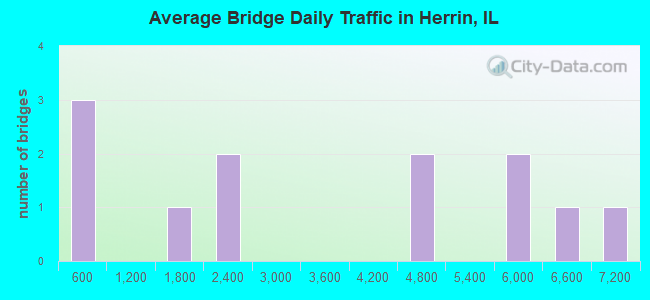
- 39,850Total average daily traffic
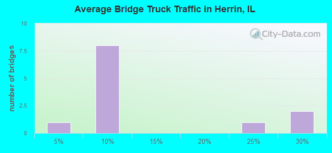
- 2,634Total average daily truck traffic
- 52,206Total future (year 2032) average daily traffic
- National Bridge Inventory (NBI) Registered Bridges for Herrin
- No street view available for this location
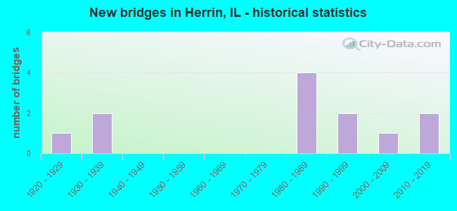
- New bridges - historical statistics
- 11920-1929
- 21930-1939
- 41980-1989
- 21990-1999
- 12000-2009
- 22010-2019
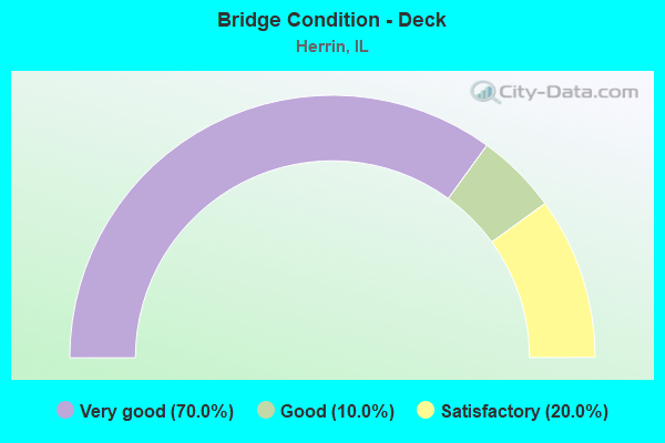
- Bridge Condition - Deck
- 70.0%Very good
- 10.0%Good
- 20.0%Satisfactory
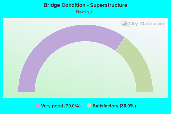
- Bridge Condition - Superstructure
- 70.0%Very good
- 30.0%Satisfactory
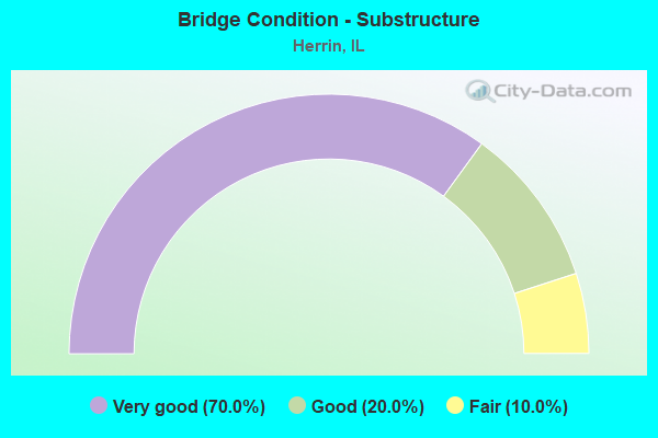
- Bridge Condition - Substructure
- 70.0%Very good
- 20.0%Good
- 10.0%Fair
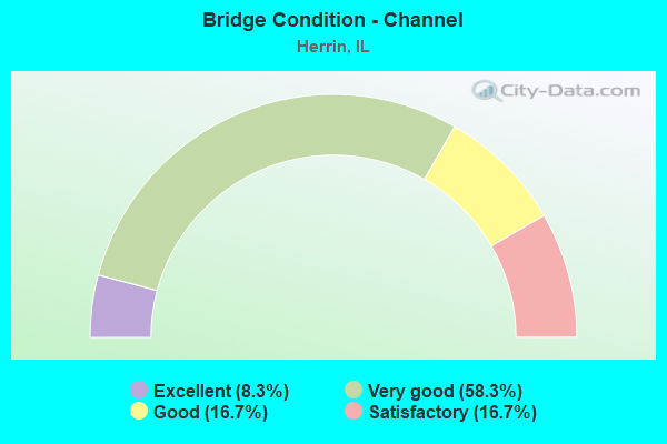
- Bridge Condition - Channel
- 8.3%Excellent
- 58.3%Very good
- 16.7%Good
- 16.7%Satisfactory
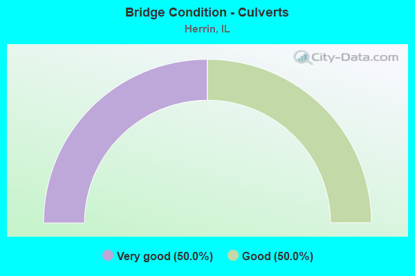
- Bridge Condition - Culverts
- 50.0%Very good
- 50.0%Good
Find on map >> Show street view
Structure Number: 1000032, Location: 0.1 MI S FRANKLIN CO (Lat: 37.860375, Lng: -89.060039), Route carried "on" structure: State highway 148, Year Built: 1931, Year Reconstructed: 1984, Status: Open, Structure Length: 13.72m (45.01ft), Average Daily Traffic: 4,400 (year 2021), Truck Traffic: 5%, Average Future Daily Traffic: 4,743 (year 2032), Design Load: HS 20, Features Intersected: BIG MUDDY RIVER
Minimum Vertical Clearance: 30+ m (98+ ft), Kilometerpoint: 30.094, Lanes on structure: 2, Base Highway Network: Yes, Owner: State Highway Agency, Approaching Roadway Width: 9.9m (32.5ft), Material/Design: Steel continuous, Design/Construction: Stringer/Multi-beam, Number Of Spans In Main Unit: 6, Length of Maximum Span: 29.6m (97.1ft), Curb-To-Curb Width: 9.8m (32.2ft), Out-to-Out Width: 10.7m (35.1ft)
Condition: Deck: Good, Superstructure: Satisfactory, Substructure: Good, Channel: Satisfactory, Operating Rating: 50.2 metric tons, Method Used To Determine Operating Rating: Load Factor (LF) rating reported by rating factor (RF) method using MS18 loading, Inventory Rating: 30.1 metric tons, Method Used To Determine Inventory Rating: Load Factor (LF) rating reported by rating factor (RF) method using MS18 loading, Structural Evaluation: Equal to present minimum criteria, Deck Geometry: Meets minimum limits, Waterway Adequacy: Equal to present desirable criteria, Approach Roadway Alignment: Equal to present desirable criteria, Designated Inspection Frequency: Every 24 months, Underwater Inspection Frequency: Every 60 months, Inspection Date: January 2021, Underwater Inspection Date: October 2020, Deck Structure Type: Concrete Cast-file-Place, Wearing Surface/Protective System: Wearing Surface: Bituminous, Membrane: Built-up, Deck Protection: Epoxy Coated Reinforcing
Find on map >> Show street view
Structure Number: 1000033, Location: 1.1 MI S FRANKLIN CO (Lat: 37.847644, Lng: -89.055150), Route carried "on" structure: State highway 148, Year Built: 1931, Year Reconstructed: 1983, Status: Open, Structure Length: 5.43m (17.81ft), Average Daily Traffic: 4,400 (year 2021), Truck Traffic: 5%, Average Future Daily Traffic: 4,743 (year 2032), Design Load: HS 20, Features Intersected: POND CREEK
Minimum Vertical Clearance: 30+ m (98+ ft), Kilometerpoint: 28.565, Lanes on structure: 2, Base Highway Network: Yes, Owner: State Highway Agency, Approaching Roadway Width: 9.8m (32.2ft), Material/Design: Steel continuous, Design/Construction: Stringer/Multi-beam, Number Of Spans In Main Unit: 3, Length of Maximum Span: 21.8m (71.5ft), Curb-To-Curb Width: 9.8m (32.2ft), Out-to-Out Width: 10.7m (35.1ft)
Condition: Deck: Satisfactory, Superstructure: Satisfactory, Substructure: Good, Channel: Very good, Operating Rating: 59.3 metric tons, Method Used To Determine Operating Rating: Load Factor (LF) rating reported by rating factor (RF) method using MS18 loading, Inventory Rating: 35.6 metric tons, Method Used To Determine Inventory Rating: Load Factor (LF) rating reported by rating factor (RF) method using MS18 loading, Structural Evaluation: Equal to present minimum criteria, Deck Geometry: Meets minimum limits, Waterway Adequacy: Equal to present desirable criteria, Approach Roadway Alignment: Equal to present desirable criteria, Designated Inspection Frequency: Every 24 months, Inspection Date: September 2020, Deck Structure Type: Concrete Cast-file-Place, Wearing Surface/Protective System: Wearing Surface: Bituminous, Membrane: Built-up, Deck Protection: Epoxy Coated Reinforcing
Find on map >> Show street view
Structure Number: 1000045, Location: 1.1 MI W OF ILL 148 (Lat: 37.737725, Lng: -89.033781), Route carried "on" structure: County highway , Year Built: 1920, Year Reconstructed: 1984, Status: Open, Structure Length: 1.01m (3.31ft), Average Daily Traffic: 1,550 (year 2021), Truck Traffic: 6%, Average Future Daily Traffic: 2,343 (year 2032), Design Load: HS 20, Features Intersected: PIGEON CREEK, Facility Carried by Structure: SBI 13 (UNMARKED)
Minimum Vertical Clearance: 30+ m (98+ ft), Kilometerpoint: 12.005, Lanes on structure: 2, Owner: State Highway Agency, Approaching Roadway Width: 8.5m (27.9ft), Material/Design: Prestressed concrete, Design/Construction: Box Beam or Girders - Multiple, Number Of Spans In Main Unit: 1, Length of Maximum Span: 8.9m (29.2ft), Curb-To-Curb Width: 9.3m (30.5ft), Out-to-Out Width: 9.3m (30.5ft)
Condition: Deck: Satisfactory, Superstructure: Satisfactory, Substructure: Fair, Channel: Satisfactory, Operating Rating: 75.8 metric tons, Method Used To Determine Operating Rating: Load Factor (LF) rating reported by rating factor (RF) method using MS18 loading, Inventory Rating: 47.0 metric tons, Method Used To Determine Inventory Rating: Load Factor (LF) rating reported by rating factor (RF) method using MS18 loading, Structural Evaluation: Somewhat better than minimum adequacy, Deck Geometry: Somewhat better than minimum adequacy, Waterway Adequacy: Equal to present desirable criteria, Approach Roadway Alignment: Equal to present desirable criteria, Designated Inspection Frequency: Every 24 months, Inspection Date: November 2021, Deck Structure Type: Concrete Precast Panels, Wearing Surface/Protective System: Wearing Surface: Bituminous, Membrane: Built-up
Find on map >> Show street view
Structure Number: 100008, Location: 0.75M E HERRIN (Lat: 37.811225, Lng: -89.004642), Route carried "on" structure: Other road , Year Built: 2016, Status: Open, Structure Length: 2.04m (6.69ft), Average Daily Traffic: 6,200 (year 2021), Truck Traffic: 6%, Average Future Daily Traffic: 6,515 (year 2032), Design Load: HS 20, Features Intersected: TRIB TO POND CREEK, Facility Carried by Structure: HERRIN ROAD
Minimum Vertical Clearance: 30+ m (98+ ft), Kilometerpoint: 5.214, Lanes on structure: 2, Base Highway Network: Yes, Owner: State Highway Agency, Approaching Roadway Width: 11.0m (36.1ft), Skew: 3 degrees, Material/Design: Steel, Design/Construction: Stringer/Multi-beam, Number Of Spans In Main Unit: 1, Length of Maximum Span: 19.5m (64.0ft), Curb-To-Curb Width: 11.0m (36.1ft), Out-to-Out Width: 11.9m (39.0ft)
Condition: Deck: Very good, Superstructure: Very good, Substructure: Very good, Channel: Excellent, Operating Rating: 80.7 metric tons, Method Used To Determine Operating Rating: Load Factor (LF) rating reported by rating factor (RF) method using MS18 loading, Inventory Rating: 42.8 metric tons, Method Used To Determine Inventory Rating: Load Factor (LF) rating reported by rating factor (RF) method using MS18 loading, Structural Evaluation: Equal to present desirable criteria, Deck Geometry: Meets minimum limits, Waterway Adequacy: Superior to present desirable criteria, Approach Roadway Alignment: Equal to present desirable criteria, Designated Inspection Frequency: Every 48 months, Inspection Date: June 2018, Deck Structure Type: Concrete Cast-file-Place, Wearing Surface/Protective System: Deck Protection: Epoxy Coated Reinforcing
Find on map >> Show street view
Structure Number: 1000081, Location: 1.0M E HERRIN (Lat: 37.813572, Lng: -88.998747), Route carried "on" structure: Other road , Year Built: 2016, Status: Open, Structure Length: 3.97m (13.02ft), Average Daily Traffic: 5,700 (year 2021), Truck Traffic: 9%, Average Future Daily Traffic: 7,658 (year 2032), Design Load: HS 20, Features Intersected: TRIB TO POND CREEK, Facility Carried by Structure: HERRIN ROAD
Minimum Vertical Clearance: 30+ m (98+ ft), Kilometerpoint: 5.793, Lanes on structure: 2, Base Highway Network: Yes, Owner: State Highway Agency, Approaching Roadway Width: 11.0m (36.1ft), Skew: 4 degrees, Material/Design: Concrete continuous, Design/Construction: Stringer/Multi-beam, Number Of Spans In Main Unit: 3, Length of Maximum Span: 12.4m (40.7ft), Curb-To-Curb Width: 11.0m (36.1ft), Out-to-Out Width: 11.9m (39.0ft)
Condition: Deck: Very good, Superstructure: Very good, Substructure: Very good, Channel: Very good, Operating Rating: 76.8 metric tons, Method Used To Determine Operating Rating: Load Factor (LF) rating reported by rating factor (RF) method using MS18 loading, Inventory Rating: 46.0 metric tons, Method Used To Determine Inventory Rating: Load Factor (LF) rating reported by rating factor (RF) method using MS18 loading, Structural Evaluation: Equal to present desirable criteria, Deck Geometry: Meets minimum limits, Waterway Adequacy: Superior to present desirable criteria, Approach Roadway Alignment: Equal to present desirable criteria, Designated Inspection Frequency: Every 48 months, Inspection Date: June 2018, Deck Structure Type: Concrete Cast-file-Place, Wearing Surface/Protective System: Deck Protection: Epoxy Coated Reinforcing
Find on map >> Show street view
Structure Number: 1002018, Location: 0.5 MI E OF COLP (Lat: 37.811103, Lng: -89.067750), Route carried "on" structure: County highway , Year Built: 2001, Status: Open, Structure Length: 1.04m (3.41ft), Average Daily Traffic: 5,700 (year 2021), Truck Traffic: 5%, Average Future Daily Traffic: 8,801 (year 2032), Design Load: HS 20, Features Intersected: TRIB TO HURRICANE CR, Facility Carried by Structure: FAS 908 (CH 11)
Minimum Vertical Clearance: 30+ m (98+ ft), Kilometerpoint: 4.908, Lanes on structure: 2, Base Highway Network: Yes, Owner: State Highway Agency, Approaching Roadway Width: 7.3m (24.0ft), Skew: 4 degrees, Material/Design: Concrete continuous, Design/Construction: Culvert, Number Of Spans In Main Unit: 3, Length of Maximum Span: 3.4m (11.2ft)
Condition: Channel: Good, Culverts: Good, Operating Rating: 97.2 metric tons, Method Used To Determine Operating Rating: Load Factor (LF) rating reported by rating factor (RF) method using MS18 loading, Inventory Rating: 63.8 metric tons, Method Used To Determine Inventory Rating: Load Factor (LF) rating reported by rating factor (RF) method using MS18 loading, Structural Evaluation: Better than present minimum criteria, Waterway Adequacy: Equal to present minimum criteria, Approach Roadway Alignment: Equal to present desirable criteria, Designated Inspection Frequency: Every 48 months, Inspection Date: Febuary 2019
Find on map >> Show street view
Structure Number: 1003116, Location: 2 MILES E HERRIN (Lat: 37.795653, Lng: -88.980708), Route carried "on" structure: County highway , Year Built: 1983, Status: Open, Structure Length: 1.86m (6.10ft), Average Daily Traffic: 2,150 (year 2021), Truck Traffic: 8%, Average Future Daily Traffic: 3,143 (year 2032), Design Load: HS 20, Features Intersected: BEAR CREEK, Facility Carried by Structure: CH 4
Minimum Vertical Clearance: 30+ m (98+ ft), Kilometerpoint: 1.432, Lanes on structure: 2, Owner: County Highway Agency, Approaching Roadway Width: 12.2m (40.0ft), Material/Design: Prestressed concrete, Design/Construction: Box Beam or Girders - Multiple, Number Of Spans In Main Unit: 1, Length of Maximum Span: 18.0m (59.1ft), Curb-To-Curb Width: 12.2m (40.0ft), Out-to-Out Width: 12.2m (40.0ft)
Condition: Deck: Very good, Superstructure: Very good, Substructure: Very good, Channel: Very good, Operating Rating: 53.8 metric tons, Method Used To Determine Operating Rating: Load Factor (LF) rating reported by rating factor (RF) method using MS18 loading, Inventory Rating: 32.4 metric tons, Method Used To Determine Inventory Rating: Load Factor (LF) rating reported by rating factor (RF) method using MS18 loading, Structural Evaluation: Equal to present desirable criteria, Deck Geometry: Equal to present minimum criteria, Waterway Adequacy: Equal to present desirable criteria, Approach Roadway Alignment: Equal to present desirable criteria, Designated Inspection Frequency: Every 48 months, Inspection Date: October 2019, Deck Structure Type: Concrete Precast Panels, Wearing Surface/Protective System: Wearing Surface: Bituminous, Membrane: Built-up
Find on map >> Show street view
Structure Number: 1003124, Location: 3.5 MI WEST MARION (Lat: 37.738008, Lng: -89.030961), Route carried "on" structure: County highway , Year Built: 1984, Status: Open, Structure Length: 1.10m (3.61ft), Average Daily Traffic: 50 (year 2021), Truck Traffic: 24%, Average Future Daily Traffic: 29 (year 2032), Design Load: HS 20, Features Intersected: NAMELESS-STREAM, Facility Carried by Structure: TR 202
Minimum Vertical Clearance: 30+ m (98+ ft), Kilometerpoint: 0.612, Lanes on structure: 2, Owner: Town or Township Highway Agency, Approaching Roadway Width: 6.1m (20.0ft), Material/Design: Prestressed concrete, Design/Construction: Box Beam or Girders - Multiple, Number Of Spans In Main Unit: 1, Length of Maximum Span: 10.4m (34.1ft), Curb-To-Curb Width: 7.4m (24.3ft), Out-to-Out Width: 7.4m (24.3ft)
Condition: Deck: Very good, Superstructure: Very good, Substructure: Very good, Channel: Very good, Operating Rating: 44.4 metric tons, Method Used To Determine Operating Rating: Assigned rating based on Load Factor Design (LFD) reported by rating factor (RF) using MS18 loading, Inventory Rating: 32.4 metric tons, Method Used To Determine Inventory Rating: Assigned rating based on Load Factor Design (LFD) reported by rating factor (RF) using MS18 loading, Structural Evaluation: Equal to present desirable criteria, Deck Geometry: Equal to present minimum criteria, Waterway Adequacy: Equal to present desirable criteria, Approach Roadway Alignment: Better than present minimum criteria, Designated Inspection Frequency: Every 48 months, Inspection Date: August 2019, Deck Structure Type: Concrete Precast Panels
Find on map >> Show street view
Structure Number: 1003125, Location: 1 MI. EAST OF HERRIN (Lat: 37.795642, Lng: -88.992561), Route carried "on" structure: County highway , Year Built: 1987, Status: Open, Structure Length: 1.89m (6.20ft), Average Daily Traffic: 2,050 (year 2021), Truck Traffic: 4%, Average Future Daily Traffic: 3,429 (year 2032), Design Load: HS 20, Features Intersected: UNNAMED STREAM, Facility Carried by Structure: FAS 2903-CH 4
Minimum Vertical Clearance: 30+ m (98+ ft), Kilometerpoint: 0.370, Lanes on structure: 2, Owner: County Highway Agency, Approaching Roadway Width: 12.2m (40.0ft), Skew: 2 degrees, Material/Design: Prestressed concrete, Design/Construction: Box Beam or Girders - Multiple, Number Of Spans In Main Unit: 1, Length of Maximum Span: 18.0m (59.1ft), Curb-To-Curb Width: 12.3m (40.4ft), Out-to-Out Width: 12.3m (40.4ft)
Condition: Deck: Very good, Superstructure: Very good, Substructure: Very good, Channel: Very good, Operating Rating: 53.8 metric tons, Method Used To Determine Operating Rating: Load Factor (LF) rating reported by rating factor (RF) method using MS18 loading, Inventory Rating: 32.4 metric tons, Method Used To Determine Inventory Rating: Load Factor (LF) rating reported by rating factor (RF) method using MS18 loading, Structural Evaluation: Equal to present desirable criteria, Deck Geometry: Equal to present minimum criteria, Waterway Adequacy: Equal to present desirable criteria, Approach Roadway Alignment: Equal to present desirable criteria, Designated Inspection Frequency: Every 48 months, Inspection Date: October 2019, Deck Structure Type: Concrete Precast Panels, Wearing Surface/Protective System: Wearing Surface: Bituminous, Membrane: Built-up
Find on map >> Show street view
Structure Number: 1003127, Location: 2 MILES NEHERRIN (Lat: 37.839744, Lng: -89.001042), Route carried "on" structure: County highway , Year Built: 1985, Status: Open, Structure Length: 3.41m (11.19ft), Average Daily Traffic: 275 (year 2021), Truck Traffic: 27%, Average Future Daily Traffic: 229 (year 2032), Design Load: HS 20, Features Intersected: LAKE CREEK, Facility Carried by Structure: TR 23
Minimum Vertical Clearance: 30+ m (98+ ft), Kilometerpoint: 0.901, Lanes on structure: 2, Owner: Town or Township Highway Agency, Approaching Roadway Width: 7.3m (24.0ft), Material/Design: Prestressed concrete, Design/Construction: Box Beam or Girders - Multiple, Number Of Spans In Main Unit: 3, Length of Maximum Span: 15.2m (49.9ft), Curb-To-Curb Width: 7.4m (24.3ft), Out-to-Out Width: 7.4m (24.3ft)
Condition: Deck: Very good, Superstructure: Very good, Substructure: Very good, Channel: Good, Operating Rating: 44.4 metric tons, Method Used To Determine Operating Rating: Assigned rating based on Load Factor Design (LFD) reported by rating factor (RF) using MS18 loading, Inventory Rating: 32.4 metric tons, Method Used To Determine Inventory Rating: Assigned rating based on Load Factor Design (LFD) reported by rating factor (RF) using MS18 loading, Structural Evaluation: Equal to present desirable criteria, Deck Geometry: Somewhat better than minimum adequacy, Waterway Adequacy: Equal to present desirable criteria, Approach Roadway Alignment: Equal to present desirable criteria, Designated Inspection Frequency: Every 48 months, Inspection Date: October 2019, Deck Structure Type: Concrete Precast Panels
Find on map >> Show street view
Structure Number: 1003155, Location: 1 MI NE OF HERRIN (Lat: 37.832517, Lng: -89.004336), Route carried "on" structure: County highway , Year Built: 1996, Status: Open, Structure Length: 1.57m (5.15ft), Average Daily Traffic: 375 (year 2021), Truck Traffic: 27%, Average Future Daily Traffic: 400 (year 2032), Design Load: HS 20, Features Intersected: POND CREEK TRIBUTARY, Facility Carried by Structure: TR 43-CHITTYVILLE
Minimum Vertical Clearance: 30+ m (98+ ft), Kilometerpoint: 1.030, Lanes on structure: 2, Owner: Town or Township Highway Agency, Approaching Roadway Width: 6.0m (19.7ft), Material/Design: Prestressed concrete, Design/Construction: Box Beam or Girders - Multiple, Number Of Spans In Main Unit: 1, Length of Maximum Span: 14.9m (48.9ft), Curb-To-Curb Width: 7.4m (24.3ft), Out-to-Out Width: 7.4m (24.3ft)
Condition: Deck: Very good, Superstructure: Very good, Substructure: Very good, Channel: Very good, Operating Rating: 44.1 metric tons, Method Used To Determine Operating Rating: Assigned rating based on Load Factor Design (LFD) reported by rating factor (RF) using MS18 loading, Inventory Rating: 32.4 metric tons, Method Used To Determine Inventory Rating: Assigned rating based on Load Factor Design (LFD) reported by rating factor (RF) using MS18 loading, Structural Evaluation: Equal to present desirable criteria, Deck Geometry: Somewhat better than minimum adequacy, Waterway Adequacy: Equal to present desirable criteria, Approach Roadway Alignment: Equal to present desirable criteria, Designated Inspection Frequency: Every 48 months, Inspection Date: June 2021, Deck Structure Type: Concrete Precast Panels
Find on map >> Show street view
Structure Number: 1006021, Location: 0.31 MI W OF IL 148 (Lat: 37.811000, Lng: -89.032997), Route carried "on" structure: Other road , Year Built: 1999, Status: Open, Structure Length: 0.91m (2.99ft), Average Daily Traffic: 7,000 (year 2021), Truck Traffic: 7%, Average Future Daily Traffic: 10,173 (year 2032), Design Load: HS 20, Features Intersected: 17TH ST DITCH, Facility Carried by Structure: FAU 9588-HERRIN ST
Minimum Vertical Clearance: 30+ m (98+ ft), Kilometerpoint: 2.671, Lanes on structure: 2, Base Highway Network: Yes, Owner: City or Municipal Highway Agency, Approaching Roadway Width: 12.2m (40.0ft), Skew: 2 degrees, Material/Design: Concrete, Design/Construction: Culvert, Number Of Spans In Main Unit: 3, Length of Maximum Span: 3.0m (9.8ft)
Condition: Channel: Very good, Culverts: Very good, Operating Rating: 44.1 metric tons, Method Used To Determine Operating Rating: Assigned rating based on Load Factor Design (LFD) reported by rating factor (RF) using MS18 loading, Inventory Rating: 32.4 metric tons, Method Used To Determine Inventory Rating: Assigned rating based on Load Factor Design (LFD) reported by rating factor (RF) using MS18 loading, Structural Evaluation: Equal to present desirable criteria, Waterway Adequacy: Equal to present desirable criteria, Approach Roadway Alignment: Equal to present desirable criteria, Designated Inspection Frequency: Every 48 months, Inspection Date: April 2019