Bridge Statistics for Hewitt, Texas (TX)
Condition, Traffic, Stress, Structural Evaluation, Project Costs
- National Bridge Inventory (NBI) Statistics
- 30Number of bridges
- 591ft / 180mTotal length
- $2,542,000Total costs
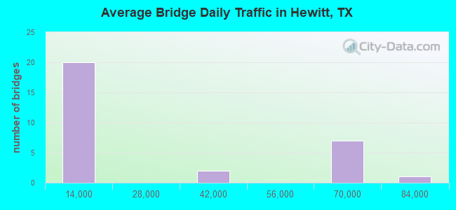
- 696,457Total average daily traffic
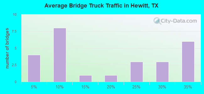
- 194,071Total average daily truck traffic
- National Bridge Inventory (NBI) Registered Bridges for Hewitt
- No street view available for this location
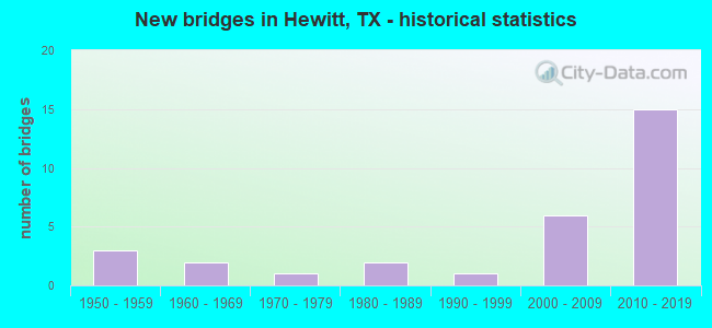
- New bridges - historical statistics
- 31950-1959
- 21960-1969
- 11970-1979
- 21980-1989
- 11990-1999
- 62000-2009
- 152010-2019
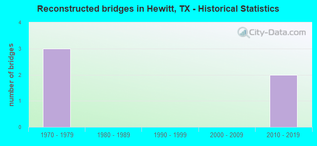
- Reconstructed bridges - Historical Statistics
- 31970-1979
- 01980-1989
- 01990-1999
- 02000-2009
- 22010-2019
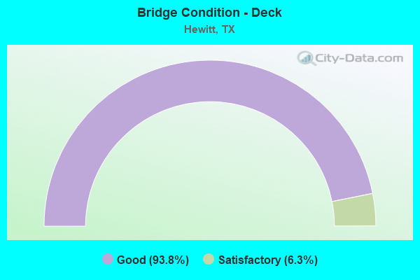
- Bridge Condition - Deck
- 93.8%Good
- 6.3%Satisfactory
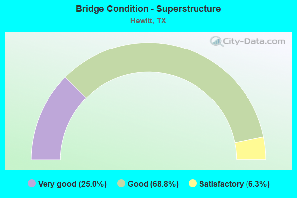
- Bridge Condition - Superstructure
- 25.0%Very good
- 68.8%Good
- 6.3%Satisfactory
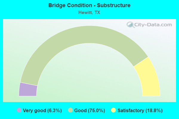
- Bridge Condition - Substructure
- 6.3%Very good
- 75.0%Good
- 18.8%Satisfactory
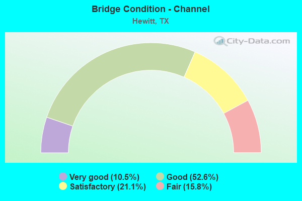
- Bridge Condition - Channel
- 10.5%Very good
- 52.6%Good
- 21.1%Satisfactory
- 15.8%Fair
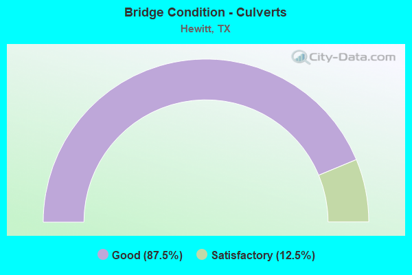
- Bridge Condition - Culverts
- 87.5%Good
- 12.5%Satisfactory
Find on map >> Show street view
Structure Number: 91610001501511, Location: 2.8 Mi S of LP 340 (Lat: 31.457483, Lng: -97.173097), Route carried "on" structure: State highway 2063, Year Built: 2009, Status: Open, Structure Length: 6.68m (21.92ft), Average Daily Traffic: 4,621 (year 2017), Truck Traffic: 3%, Average Future Daily Traffic: 7,680 (year 2037), Design Load: HL 93, Features Intersected: IH 35
Minimum Vertical Clearance: 30+ m (98+ ft), Kilometerpoint: 13.338, Lanes on structure: 6, Lanes under structure: 7, Owner: State Highway Agency, Approaching Roadway Width: 23.2m (76.1ft), Material/Design: Prestressed concrete, Design/Construction: Stringer/Multi-beam, Number Of Spans In Main Unit: 2, Length of Maximum Span: 33.5m (109.9ft), Curb or Sidewalk Widths: Left: 0.0m, Right: 1.7m (5.6ft), Curb-To-Curb Width: 23.2m (76.1ft), Out-to-Out Width: 25.5m (83.7ft)
Condition: Deck: Good, Superstructure: Good, Substructure: Very good, Operating Rating: 54.4 metric tons, Method Used To Determine Operating Rating: Assigned ratings based on Load and Resistance Factor Design (LRFD) reported in metric tons, Inventory Rating: 32.7 metric tons, Method Used To Determine Inventory Rating: Assigned ratings based on Load and Resistance Factor Design (LRFD) reported in metric tons, Structural Evaluation: Better than present minimum criteria, Deck Geometry: Meets minimum limits, Underclear: Somewhat better than minimum adequacy, Approach Roadway Alignment: Equal to present desirable criteria, Designated Inspection Frequency: Every 24 months, Inspection Date: Febuary 2021, Deck Structure Type: Concrete Cast-file-Place
Find on map >> Show street view
Structure Number: 91610001501609, Location: 0.2 Mi S of FM 2063 (Lat: 31.455492, Lng: -97.174328), Route carried "on" structure: Interstate 35, Year Built: 2015, Status: Open, Structure Length: 1.10m (3.61ft), Average Daily Traffic: 69,580 (year 2017), Truck Traffic: 34%, Average Future Daily Traffic: 97,410 (year 2037), Design Load: HL 93, Features Intersected: Chambers Creek
Minimum Vertical Clearance: 30+ m (98+ ft), Kilometerpoint: 13.029, Lanes on structure: 10, Base Highway Network: Yes, Owner: State Highway Agency, Approaching Roadway Width: 54.9m (180.1ft), Skew: 39 degrees, Material/Design: Concrete, Design/Construction: Culvert, Number Of Spans In Main Unit: 3, Length of Maximum Span: 3.0m (9.8ft)
Condition: Channel: Good, Culverts: Good, Operating Rating: 54.4 metric tons, Method Used To Determine Operating Rating: Assigned ratings based on Load and Resistance Factor Design (LRFD) reported in metric tons, Inventory Rating: 32.7 metric tons, Method Used To Determine Inventory Rating: Assigned ratings based on Load and Resistance Factor Design (LRFD) reported in metric tons, Structural Evaluation: Better than present minimum criteria, Waterway Adequacy: Equal to present minimum criteria, Approach Roadway Alignment: Equal to present desirable criteria, Designated Inspection Frequency: Every 24 months, Inspection Date: March 2021
Find on map >> Show street view
Structure Number: 91610001501625, Location: 0.4 MI. S. of FM 3148 (Lat: 31.417389, Lng: -97.197761), Route carried "on" structure: ServiceState highway 35, Year Built: 2014, Status: Open, Structure Length: 7.99m (26.21ft), Average Daily Traffic: 3,060 (year 2017), Truck Traffic: 3%, Average Future Daily Traffic: 4,290 (year 2037), Design Load: HL 93, Features Intersected: BULLHIDE CREEK
Minimum Vertical Clearance: 30+ m (98+ ft), Kilometerpoint: 3.851, Lanes on structure: 2, Owner: State Highway Agency, Approaching Roadway Width: 9.1m (29.9ft), Skew: 4 degrees, Material/Design: Prestressed concrete, Design/Construction: Stringer/Multi-beam, Number Of Spans In Main Unit: 3, Length of Maximum Span: 26.8m (87.9ft), Curb-To-Curb Width: 9.5m (31.2ft), Out-to-Out Width: 10.4m (34.1ft)
Condition: Deck: Good, Superstructure: Very good, Substructure: Good, Channel: Good, Operating Rating: 54.4 metric tons, Method Used To Determine Operating Rating: Assigned ratings based on Load and Resistance Factor Design (LRFD) reported in metric tons, Inventory Rating: 32.7 metric tons, Method Used To Determine Inventory Rating: Assigned ratings based on Load and Resistance Factor Design (LRFD) reported in metric tons, Structural Evaluation: Better than present minimum criteria, Deck Geometry: Meets minimum limits, Waterway Adequacy: Equal to present desirable criteria, Approach Roadway Alignment: Equal to present desirable criteria, Designated Inspection Frequency: Every 24 months, Inspection Date: April 2021, Deck Structure Type: Concrete Precast Panels
Find on map >> Show street view
Structure Number: 91610001501626, Location: 0.4 MI S OF FM 3148 (Lat: 31.417408, Lng: -97.197244), Route carried "on" structure: Interstate 35, Year Built: 2015, Status: Open, Structure Length: 7.92m (25.98ft), Average Daily Traffic: 34,790 (year 2017), Truck Traffic: 34%, Average Future Daily Traffic: 48,705 (year 2037), Design Load: HL 93, Features Intersected: BULLHIDE CREEK
Minimum Vertical Clearance: 30+ m (98+ ft), Kilometerpoint: 4.582, Lanes on structure: 3, Base Highway Network: Yes, Owner: State Highway Agency, Approaching Roadway Width: 17.7m (58.1ft), Skew: 4 degrees, Material/Design: Prestressed concrete, Design/Construction: Stringer/Multi-beam, Number Of Spans In Main Unit: 3, Length of Maximum Span: 26.8m (87.9ft), Curb-To-Curb Width: 17.5m (57.4ft), Out-to-Out Width: 18.3m (60.0ft)
Condition: Deck: Good, Superstructure: Very good, Substructure: Good, Channel: Good, Operating Rating: 54.4 metric tons, Method Used To Determine Operating Rating: Assigned ratings based on Load and Resistance Factor Design (LRFD) reported in metric tons, Inventory Rating: 32.7 metric tons, Method Used To Determine Inventory Rating: Assigned ratings based on Load and Resistance Factor Design (LRFD) reported in metric tons, Structural Evaluation: Better than present minimum criteria, Deck Geometry: Better than present minimum criteria, Waterway Adequacy: Superior to present desirable criteria, Approach Roadway Alignment: Equal to present desirable criteria, Designated Inspection Frequency: Every 24 months, Inspection Date: April 2021, Deck Structure Type: Concrete Precast Panels
Find on map >> Show street view
Structure Number: 91610001501627, Location: 0.4 MI S OF FM 3148 (Lat: 31.417122, Lng: -97.197039), Route carried "on" structure: Interstate 35, Year Built: 2015, Status: Open, Structure Length: 7.92m (25.98ft), Average Daily Traffic: 34,790 (year 2017), Truck Traffic: 34%, Average Future Daily Traffic: 48,705 (year 2037), Design Load: HL 93, Features Intersected: BULLHIDE CREEK
Minimum Vertical Clearance: 30+ m (98+ ft), Kilometerpoint: 4.582, Lanes on structure: 4, Base Highway Network: Yes, Owner: State Highway Agency, Approaching Roadway Width: 17.7m (58.1ft), Skew: 4 degrees, Material/Design: Prestressed concrete, Design/Construction: Stringer/Multi-beam, Number Of Spans In Main Unit: 3, Length of Maximum Span: 26.8m (87.9ft), Curb-To-Curb Width: 8.7m (28.5ft), Out-to-Out Width: 18.3m (60.0ft)
Condition: Deck: Good, Superstructure: Very good, Substructure: Good, Channel: Good, Operating Rating: 54.4 metric tons, Method Used To Determine Operating Rating: Assigned ratings based on Load and Resistance Factor Design (LRFD) reported in metric tons, Inventory Rating: 32.7 metric tons, Method Used To Determine Inventory Rating: Assigned ratings based on Load and Resistance Factor Design (LRFD) reported in metric tons, Structural Evaluation: Better than present minimum criteria, Deck Geometry: High priority of replacement, Waterway Adequacy: Superior to present desirable criteria, Approach Roadway Alignment: Equal to present desirable criteria, Designated Inspection Frequency: Every 24 months, Inspection Date: April 2021, Deck Structure Type: Concrete Precast Panels
Find on map >> Show street view
Structure Number: 91610001501628, Location: 0.4 MI S OF FM 3148 (Lat: 31.417428, Lng: -97.196156), Route carried "on" structure: ServiceState highway 35, Year Built: 2015, Status: Open, Structure Length: 7.92m (25.98ft), Average Daily Traffic: 3,060 (year 2017), Truck Traffic: 3%, Average Future Daily Traffic: 4,290 (year 2037), Design Load: HL 93, Features Intersected: BULLHIDE CREEK
Minimum Vertical Clearance: 30+ m (98+ ft), Kilometerpoint: 4.532, Lanes on structure: 2, Owner: State Highway Agency, Approaching Roadway Width: 9.1m (29.9ft), Skew: 4 degrees, Material/Design: Prestressed concrete, Design/Construction: Stringer/Multi-beam, Number Of Spans In Main Unit: 3, Length of Maximum Span: 26.8m (87.9ft), Curb-To-Curb Width: 9.6m (31.5ft), Out-to-Out Width: 10.4m (34.1ft)
Condition: Deck: Good, Superstructure: Good, Substructure: Good, Channel: Good, Operating Rating: 54.4 metric tons, Method Used To Determine Operating Rating: Assigned ratings based on Load and Resistance Factor Design (LRFD) reported in metric tons, Inventory Rating: 32.7 metric tons, Method Used To Determine Inventory Rating: Assigned ratings based on Load and Resistance Factor Design (LRFD) reported in metric tons, Structural Evaluation: Better than present minimum criteria, Deck Geometry: Meets minimum limits, Waterway Adequacy: Superior to present desirable criteria, Approach Roadway Alignment: Equal to present desirable criteria, Designated Inspection Frequency: Every 24 months, Inspection Date: April 2021, Deck Structure Type: Concrete Precast Panels
Find on map >> Show street view
Structure Number: 91610001501631, Location: 9.50 MI N OF FM 107 (Lat: 31.421417, Lng: -97.194228), Route carried "on" structure: State highway 1695, Year Built: 2015, Status: Open, Structure Length: 7.96m (26.12ft), Average Daily Traffic: 1,344 (year 2017), Truck Traffic: 6%, Average Future Daily Traffic: 1,833 (year 2037), Design Load: HL 93, Features Intersected: IH 35
Minimum Vertical Clearance: 30+ m (98+ ft), Kilometerpoint: 9.656, Lanes on structure: 1, Lanes under structure: 6, Owner: State Highway Agency, Approaching Roadway Width: 12.8m (42.0ft), Material/Design: Prestressed concrete, Design/Construction: Stringer/Multi-beam, Number Of Spans In Main Unit: 2, Length of Maximum Span: 44.5m (146.0ft), Curb-To-Curb Width: 7.6m (24.9ft), Out-to-Out Width: 10.7m (35.1ft)
Condition: Deck: Good, Superstructure: Very good, Substructure: Good, Operating Rating: 54.4 metric tons, Method Used To Determine Operating Rating: Assigned ratings based on Load and Resistance Factor Design (LRFD) reported in metric tons, Inventory Rating: 32.7 metric tons, Method Used To Determine Inventory Rating: Assigned ratings based on Load and Resistance Factor Design (LRFD) reported in metric tons, Structural Evaluation: Better than present minimum criteria, Deck Geometry: Meets minimum limits, Underclear: Equal to present minimum criteria, Approach Roadway Alignment: Equal to present desirable criteria, Designated Inspection Frequency: Every 24 months, Inspection Date: April 2021, Deck Structure Type: Concrete Precast Panels
Find on map >> Show street view
Structure Number: 91610001501632, Location: 9.50 MI N OF FM 107 (Lat: 31.421633, Lng: -97.194108), Route carried "on" structure: State highway 1695, Year Built: 2015, Status: Open, Structure Length: 7.96m (26.12ft), Average Daily Traffic: 1,344 (year 2017), Truck Traffic: 6%, Average Future Daily Traffic: 1,833 (year 2037), Design Load: HL 93, Features Intersected: IH 35
Minimum Vertical Clearance: 30+ m (98+ ft), Kilometerpoint: 9.656, Lanes on structure: 6, Lanes under structure: 6, Owner: State Highway Agency, Approaching Roadway Width: 12.8m (42.0ft), Material/Design: Prestressed concrete, Design/Construction: Stringer/Multi-beam, Number Of Spans In Main Unit: 2, Length of Maximum Span: 44.5m (146.0ft), Curb-To-Curb Width: 25.6m (84.0ft), Out-to-Out Width: 26.2m (86.0ft)
Condition: Deck: Good, Superstructure: Good, Substructure: Good, Operating Rating: 54.4 metric tons, Method Used To Determine Operating Rating: Assigned ratings based on Load and Resistance Factor Design (LRFD) reported in metric tons, Inventory Rating: 32.7 metric tons, Method Used To Determine Inventory Rating: Assigned ratings based on Load and Resistance Factor Design (LRFD) reported in metric tons, Structural Evaluation: Better than present minimum criteria, Deck Geometry: Somewhat better than minimum adequacy, Underclear: Equal to present minimum criteria, Approach Roadway Alignment: Equal to present desirable criteria, Designated Inspection Frequency: Every 24 months, Inspection Date: April 2021, Deck Structure Type: Concrete Precast Panels
Find on map >> Show street view
Structure Number: 91610001501633, Location: 9.50 MI N OF FM 107 (Lat: 31.421792, Lng: -97.194014), Route carried "on" structure: State highway 1695, Year Built: 2015, Status: Open, Structure Length: 7.96m (26.12ft), Average Daily Traffic: 1,345 (year 2017), Truck Traffic: 6%, Average Future Daily Traffic: 1,883 (year 2037), Design Load: HL 93, Features Intersected: IH 35
Minimum Vertical Clearance: 30+ m (98+ ft), Kilometerpoint: 5.195, Lanes on structure: 1, Lanes under structure: 6, Owner: State Highway Agency, Approaching Roadway Width: 12.8m (42.0ft), Material/Design: Prestressed concrete, Design/Construction: Stringer/Multi-beam, Number Of Spans In Main Unit: 2, Length of Maximum Span: 44.5m (146.0ft), Curb-To-Curb Width: 7.6m (24.9ft), Out-to-Out Width: 10.7m (35.1ft)
Condition: Deck: Good, Superstructure: Good, Substructure: Good, Operating Rating: 54.4 metric tons, Method Used To Determine Operating Rating: Assigned ratings based on Load and Resistance Factor Design (LRFD) reported in metric tons, Inventory Rating: 32.7 metric tons, Method Used To Determine Inventory Rating: Assigned ratings based on Load and Resistance Factor Design (LRFD) reported in metric tons, Structural Evaluation: Better than present minimum criteria, Deck Geometry: Meets minimum limits, Underclear: High priority of corrective action, Approach Roadway Alignment: Equal to present desirable criteria, Designated Inspection Frequency: Every 24 months, Inspection Date: April 2021, Deck Structure Type: Concrete Precast Panels
Find on map >> Show street view
Structure Number: 91610001502606, Location: 0.10 Mi S of FM 1695 (Lat: 31.420203, Lng: -97.195978), Route carried "on" structure: Interstate 35, Year Built: 2015, Status: Open, Structure Length: 0.73m (2.40ft), Average Daily Traffic: 65,120 (year 2011), Truck Traffic: 28%, Average Future Daily Traffic: 91,170 (year 2031), Design Load: HL 93, Features Intersected: Trib Bullhide Creek
Minimum Vertical Clearance: 30+ m (98+ ft), Kilometerpoint: 11.148, Lanes on structure: 10, Owner: State Highway Agency, Approaching Roadway Width: 55.5m (182.1ft), Skew: 39 degrees, Material/Design: Concrete, Design/Construction: Culvert, Number Of Spans In Main Unit: 2, Length of Maximum Span: 2.4m (7.9ft)
Condition: Channel: Very good, Culverts: Good, Operating Rating: 54.4 metric tons, Method Used To Determine Operating Rating: Assigned ratings based on Load and Resistance Factor Design (LRFD) reported in metric tons, Inventory Rating: 32.7 metric tons, Method Used To Determine Inventory Rating: Assigned ratings based on Load and Resistance Factor Design (LRFD) reported in metric tons, Structural Evaluation: Better than present minimum criteria, Waterway Adequacy: Superior to present desirable criteria, Approach Roadway Alignment: Equal to present desirable criteria, Designated Inspection Frequency: Every 48 months, Inspection Date: December 2020
Find on map >> Show street view
Structure Number: 91610001502607, Location: 1.30 Mi N of FM 3148 (Lat: 31.437800, Lng: -97.184061), Route carried "on" structure: Interstate 35, Year Built: 2015, Status: Open, Structure Length: 2.07m (6.79ft), Average Daily Traffic: 65,120 (year 2011), Truck Traffic: 28%, Average Future Daily Traffic: 91,170 (year 2031), Design Load: HL 93, Features Intersected: Castleman Creek
Minimum Vertical Clearance: 30+ m (98+ ft), Kilometerpoint: 13.459, Lanes on structure: 10, Owner: State Highway Agency, Approaching Roadway Width: 55.5m (182.1ft), Skew: 39 degrees, Material/Design: Concrete, Design/Construction: Culvert, Number Of Spans In Main Unit: 4, Length of Maximum Span: 3.0m (9.8ft)
Condition: Channel: Good, Culverts: Good, Operating Rating: 54.4 metric tons, Method Used To Determine Operating Rating: Assigned ratings based on Load and Resistance Factor Design (LRFD) reported in metric tons, Inventory Rating: 32.7 metric tons, Method Used To Determine Inventory Rating: Assigned ratings based on Load and Resistance Factor Design (LRFD) reported in metric tons, Structural Evaluation: Better than present minimum criteria, Waterway Adequacy: Superior to present desirable criteria, Approach Roadway Alignment: Equal to present desirable criteria, Designated Inspection Frequency: Every 48 months, Inspection Date: December 2020
Find on map >> Show street view
Structure Number: 91610001521436, Location: 0.2 Mi N of FM 2063 (Lat: 31.464611, Lng: -97.182222), Route carried "on" structure: State highway 3476, Year Built: 1992, Year Reconstructed: 2010, Status: Open, Structure Length: 2.93m (9.61ft), Average Daily Traffic: 11,618 (year 2020), Truck Traffic: 6%, Average Future Daily Traffic: 13,600 (year 2037), Design Load: HS 20, Features Intersected: Chambers Creek
Minimum Vertical Clearance: 30+ m (98+ ft), Kilometerpoint: 5.855, Lanes on structure: 5, Base Highway Network: Yes, Owner: State Highway Agency, Approaching Roadway Width: 25.6m (84.0ft), Skew: 2 degrees, Material/Design: Concrete, Design/Construction: Stringer/Multi-beam, Number Of Spans In Main Unit: 3, Length of Maximum Span: 9.8m (32.2ft), Curb-To-Curb Width: 25.6m (84.0ft), Out-to-Out Width: 26.2m (86.0ft)
Condition: Deck: Good, Superstructure: Good, Substructure: Good, Channel: Satisfactory, Operating Rating: 54.4 metric tons, Method Used To Determine Operating Rating: Assigned rating based on Load Factor Design (LFD) reported in metric tons, Inventory Rating: 32.7 metric tons, Method Used To Determine Inventory Rating: Assigned rating based on Load Factor Design (LFD) reported in metric tons, Structural Evaluation: Better than present minimum criteria, Deck Geometry: Superior to present desirable criteria, Waterway Adequacy: Superior to present desirable criteria, Approach Roadway Alignment: Equal to present desirable criteria, Designated Inspection Frequency: Every 24 months, Inspection Date: January 2021, Deck Structure Type: Concrete Cast-file-Place, Wearing Surface/Protective System: Wearing Surface: Bituminous
Find on map >> Show street view
Structure Number: 91610206001001, Location: 0.2 Mi SW of IH 35 (Lat: 31.456272, Lng: -97.175481), Route carried "on" structure: State highway 2113, Year Built: 1957, Year Reconstructed: 1984, Status: Open, Structure Length: 1.86m (6.10ft), Average Daily Traffic: 5,769 (year 2020), Truck Traffic: 7%, Average Future Daily Traffic: 5,410 (year 2033), Design Load: H 15, Features Intersected: Chambers Creek
Minimum Vertical Clearance: 30+ m (98+ ft), Kilometerpoint: 0.435, Lanes on structure: 2, Owner: State Highway Agency, Approaching Roadway Width: 13.4m (44.0ft), Material/Design: Concrete, Design/Construction: Stringer/Multi-beam, Number Of Spans In Main Unit: 2, Length of Maximum Span: 9.1m (29.9ft), Curb-To-Curb Width: 13.0m (42.7ft), Out-to-Out Width: 14.0m (45.9ft)
Condition: Deck: Good, Superstructure: Satisfactory, Substructure: Satisfactory, Channel: Satisfactory, Operating Rating: 52.6 metric tons, Method Used To Determine Operating Rating: Load Factor (LF), Inventory Rating: 31.7 metric tons, Method Used To Determine Inventory Rating: Load Factor (LF), Structural Evaluation: Equal to present minimum criteria, Deck Geometry: Somewhat better than minimum adequacy, Waterway Adequacy: Superior to present desirable criteria, Approach Roadway Alignment: Equal to present desirable criteria, Length Of Structure Improvement: 2.74m (8.99ft), Designated Inspection Frequency: Every 24 months, Inspection Date: Febuary 2021, Bridge Improvement Cost: $300,000, Roadway Improvement Cost: $100,000, Total Project Cost: $500,000, Deck Structure Type: Concrete Cast-file-Place, Wearing Surface/Protective System: Wearing Surface: Bituminous
Find on map >> Show street view
Structure Number: 91610206001002, Location: 1.6 Mi SW of IH 35 (Lat: 31.445092, Lng: -97.193561), Route carried "on" structure: State highway 2113, Year Built: 1957, Year Reconstructed: 1984, Status: Open, Structure Length: 1.86m (6.10ft), Average Daily Traffic: 5,769 (year 2020), Truck Traffic: 8%, Average Future Daily Traffic: 8,520 (year 2033), Design Load: H 15, Features Intersected: Castleman Creek
Minimum Vertical Clearance: 30+ m (98+ ft), Kilometerpoint: 2.739, Lanes on structure: 2, Owner: State Highway Agency, Approaching Roadway Width: 13.4m (44.0ft), Material/Design: Concrete, Design/Construction: Stringer/Multi-beam, Number Of Spans In Main Unit: 2, Length of Maximum Span: 9.1m (29.9ft), Curb-To-Curb Width: 13.0m (42.7ft), Out-to-Out Width: 14.0m (45.9ft)
Condition: Deck: Good, Superstructure: Good, Substructure: Satisfactory, Channel: Fair, Operating Rating: 49.9 metric tons, Method Used To Determine Operating Rating: Load Factor (LF), Inventory Rating: 29.9 metric tons, Method Used To Determine Inventory Rating: Load Factor (LF), Structural Evaluation: Equal to present minimum criteria, Deck Geometry: Somewhat better than minimum adequacy, Waterway Adequacy: Superior to present desirable criteria, Approach Roadway Alignment: Equal to present desirable criteria, Length Of Structure Improvement: 2.74m (8.99ft), Designated Inspection Frequency: Every 24 months, Inspection Date: Febuary 2021, Bridge Improvement Cost: $300,000, Roadway Improvement Cost: $100,000, Total Project Cost: $500,000, Deck Structure Type: Concrete Cast-file-Place, Wearing Surface/Protective System: Wearing Surface: Bituminous
Find on map >> Show street view
Structure Number: 91610206001003, Location: 3.6 Mi SW of IH 35 (Lat: 31.429939, Lng: -97.221056), Route carried "on" structure: State highway 2113, Year Built: 1957, Year Reconstructed: 1984, Status: Open, Structure Length: 1.86m (6.10ft), Average Daily Traffic: 6,393 (year 2020), Truck Traffic: 5%, Average Future Daily Traffic: 6,790 (year 2033), Design Load: H 15, Features Intersected: Bullhide Creek
Minimum Vertical Clearance: 30+ m (98+ ft), Kilometerpoint: 5.718, Lanes on structure: 2, Owner: State Highway Agency, Approaching Roadway Width: 13.4m (44.0ft), Material/Design: Concrete, Design/Construction: Stringer/Multi-beam, Number Of Spans In Main Unit: 2, Length of Maximum Span: 9.1m (29.9ft), Curb-To-Curb Width: 13.0m (42.7ft), Out-to-Out Width: 14.0m (45.9ft)
Condition: Deck: Good, Superstructure: Good, Substructure: Satisfactory, Channel: Satisfactory, Operating Rating: 54.4 metric tons, Method Used To Determine Operating Rating: Load Factor (LF), Inventory Rating: 32.7 metric tons, Method Used To Determine Inventory Rating: Load Factor (LF), Structural Evaluation: Equal to present minimum criteria, Deck Geometry: Somewhat better than minimum adequacy, Waterway Adequacy: Equal to present minimum criteria, Approach Roadway Alignment: Equal to present desirable criteria, Length Of Structure Improvement: 2.74m (8.99ft), Designated Inspection Frequency: Every 24 months, Inspection Date: Febuary 2021, Bridge Improvement Cost: $300,000, Roadway Improvement Cost: $100,000, Total Project Cost: $500,000, Deck Structure Type: Concrete Cast-file-Place, Wearing Surface/Protective System: Wearing Surface: Bituminous
Find on map >> Show street view
Structure Number: 91610250601001, Location: 1.2 Mi N of FM 2113 (Lat: 31.452186, Lng: -97.202197), Route carried "on" structure: State highway 1695, Year Built: 1961, Year Reconstructed: 2010, Status: Open, Structure Length: 1.49m (4.89ft), Average Daily Traffic: 8,238 (year 2020), Truck Traffic: 22%, Average Future Daily Traffic: 5,390 (year 2033), Features Intersected: Castleman Creek
Minimum Vertical Clearance: 30+ m (98+ ft), Kilometerpoint: 37.900, Lanes on structure: 5, Base Highway Network: Yes, Owner: State Highway Agency, Approaching Roadway Width: 22.9m (75.1ft), Material/Design: Concrete, Design/Construction: Culvert, Number Of Spans In Main Unit: 6, Length of Maximum Span: 2.1m (6.9ft), Curb or Sidewalk Widths: Left: 0.0m, Right: 2.2m (7.2ft), Curb-To-Curb Width: 22.9m (75.1ft), Out-to-Out Width: 25.8m (84.6ft)
Condition: Channel: Good, Culverts: Good, Operating Rating: 39.9 metric tons, Method Used To Determine Operating Rating: Load Factor (LF), Inventory Rating: 23.6 metric tons, Method Used To Determine Inventory Rating: Load Factor (LF), Structural Evaluation: Somewhat better than minimum adequacy, Deck Geometry: Equal to present minimum criteria, Waterway Adequacy: Equal to present minimum criteria, Approach Roadway Alignment: Equal to present desirable criteria, Designated Inspection Frequency: Every 24 months, Inspection Date: January 2021, Deck Structure Type: Concrete Cast-file-Place, Wearing Surface/Protective System: Wearing Surface: Bituminous
Find on map >> Show street view
Structure Number: 91610250601003, Location: 1.2 Mi NW of IH 35 (Lat: 31.435436, Lng: -97.206381), Route carried "on" structure: State highway 1695, Year Built: 2008, Status: Open, Structure Length: 21.49m (70.51ft), Average Daily Traffic: 8,238 (year 2020), Truck Traffic: 22%, Average Future Daily Traffic: 5,390 (year 2033), Design Load: HL 93, Features Intersected: UP RR & FM 2113
Minimum Vertical Clearance: 30+ m (98+ ft), Kilometerpoint: 40.498, Lanes on structure: 5, Lanes under structure: 8, Owner: State Highway Agency, Approaching Roadway Width: 25.6m (84.0ft), Skew: 9 degrees, Material/Design: Prestressed concrete, Design/Construction: Stringer/Multi-beam, Number Of Spans In Main Unit: 7, Length of Maximum Span: 36.6m (120.1ft), Curb-To-Curb Width: 25.6m (84.0ft), Out-to-Out Width: 26.2m (86.0ft)
Condition: Deck: Good, Superstructure: Good, Substructure: Good, Operating Rating: 54.4 metric tons, Method Used To Determine Operating Rating: Assigned ratings based on Load and Resistance Factor Design (LRFD) reported in metric tons, Inventory Rating: 32.7 metric tons, Method Used To Determine Inventory Rating: Assigned ratings based on Load and Resistance Factor Design (LRFD) reported in metric tons, Structural Evaluation: Better than present minimum criteria, Deck Geometry: Superior to present desirable criteria, Underclear: Equal to present minimum criteria, Approach Roadway Alignment: Equal to present desirable criteria, Designated Inspection Frequency: Every 24 months, Inspection Date: Febuary 2021, Deck Structure Type: Concrete Precast Panels
Find on map >> Show street view
Structure Number: 91610250601004, Location: 0.2 Mi W of IH 35 (Lat: 31.423369, Lng: -97.197581), Route carried "on" structure: State highway 1695, Year Built: 2008, Status: Open, Structure Length: 2.10m (6.89ft), Average Daily Traffic: 8,238 (year 2020), Truck Traffic: 22%, Average Future Daily Traffic: 5,390 (year 2033), Design Load: HS 20, Features Intersected: Trib of Bullhide Creek
Minimum Vertical Clearance: 30+ m (98+ ft), Kilometerpoint: 42.416, Lanes on structure: 5, Owner: State Highway Agency, Approaching Roadway Width: 25.9m (85.0ft), Skew: 4 degrees, Material/Design: Concrete, Design/Construction: Culvert, Number Of Spans In Main Unit: 5, Length of Maximum Span: 1.5m (4.9ft)
Condition: Channel: Good, Culverts: Good, Operating Rating: 54.4 metric tons, Method Used To Determine Operating Rating: Assigned rating based on Load Factor Design (LFD) reported in metric tons, Inventory Rating: 32.7 metric tons, Method Used To Determine Inventory Rating: Assigned rating based on Load Factor Design (LFD) reported in metric tons, Structural Evaluation: Better than present minimum criteria, Waterway Adequacy: Equal to present minimum criteria, Approach Roadway Alignment: Equal to present desirable criteria, Designated Inspection Frequency: Every 48 months, Inspection Date: January 2021
Find on map >> Show street view
Structure Number: 91610262501002, Location: 0.2 Mi S of FM 2063 (Lat: 31.454133, Lng: -97.175517), Route carried "on" structure: Ramp State highway 2113, Year Built: 2013, Status: Open, Structure Length: 71.17m (233.50ft), Average Daily Traffic: 2,100 (year 2013), Truck Traffic: 10%, Average Future Daily Traffic: 2,900 (year 2033), Design Load: HL 93, Features Intersected: IH 35 & FM 2063
Minimum Vertical Clearance: 30+ m (98+ ft), Kilometerpoint: 0.343, Lanes on structure: 1, Lanes under structure: 14, Base Highway Network: Yes, Owner: State Highway Agency, Approaching Roadway Width: 7.9m (25.9ft), Material/Design: Steel continuous, Design/Construction: Box Beam or Girders - Multiple, Number Of Spans In Main Unit: 4, Number Of Approach Spans: 13, Length of Maximum Span: 96.9m (317.9ft), Curb-To-Curb Width: 7.9m (25.9ft), Out-to-Out Width: 8.5m (27.9ft)
Condition: Deck: Good, Superstructure: Good, Substructure: Good, Channel: Very good, Operating Rating: 54.4 metric tons, Method Used To Determine Operating Rating: Assigned ratings based on Load and Resistance Factor Design (LRFD) reported in metric tons, Inventory Rating: 32.7 metric tons, Method Used To Determine Inventory Rating: Assigned ratings based on Load and Resistance Factor Design (LRFD) reported in metric tons, Structural Evaluation: Better than present minimum criteria, Deck Geometry: Equal to present desirable criteria, Underclear: Equal to present minimum criteria, Waterway Adequacy: Superior to present desirable criteria, Approach Roadway Alignment: Equal to present desirable criteria, Designated Inspection Frequency: Every 24 months, Critical Feature Inspection Frequency: Every 24 months, Inspection Date: Febuary 2021, Critical Feature Inspection Date: September 2021, Deck Structure Type: Corrugated Steel, Wearing Surface/Protective System: Wearing Surface: Monolithic Concrete
Find on map >> Show street view
Structure Number: 91610AA0328001, Location: 1.50 MI NE OF FM 2837 (Lat: 31.444661, Lng: -97.228536), Route carried "on" structure: County highway 105, Year Built: 1965, Status: Open, Structure Length: 0.82m (2.69ft), Average Daily Traffic: 644 (year 2020), Truck Traffic: 1%, Average Future Daily Traffic: 350 (year 2036), Features Intersected: BULL HIDE CRK #86, Facility Carried by Structure: WARREN RD
Minimum Vertical Clearance: 30+ m (98+ ft), Kilometerpoint: 1.127, Lanes on structure: 2, Owner: County Highway Agency, Approaching Roadway Width: 5.5m (18.0ft), Material/Design: Concrete, Design/Construction: Culvert, Number Of Spans In Main Unit: 3, Length of Maximum Span: 2.4m (7.9ft), Curb-To-Curb Width: 8.5m (27.9ft), Out-to-Out Width: 8.9m (29.2ft)
Condition: Channel: Good, Culverts: Good, Operating Rating: 39.9 metric tons, Method Used To Determine Operating Rating: Load Factor (LF), Inventory Rating: 23.6 metric tons, Method Used To Determine Inventory Rating: Load Factor (LF), Structural Evaluation: Equal to present minimum criteria, Deck Geometry: Somewhat better than minimum adequacy, Waterway Adequacy: Meets minimum limits, Approach Roadway Alignment: Equal to present desirable criteria, Length Of Structure Improvement: 1.83m (6.00ft), Designated Inspection Frequency: Every 24 months, Inspection Date: March 2020, Bridge Improvement Cost: $167,000, Roadway Improvement Cost: $41,000, Total Project Cost: $208,000, Deck Structure Type: Concrete Cast-file-Place
Find on map >> Show street view
Structure Number: 91610AA9536001, Location: 0.3 MI S OF FM 3148 (Lat: 31.416453, Lng: -97.193831), Route carried "on" structure: County highway 9536, Year Built: 2006, Status: Open, Structure Length: 3.29m (10.79ft), Average Daily Traffic: 1,682 (year 2020), Average Future Daily Traffic: 80 (year 2036), Design Load: HL 93, Features Intersected: BULL HIDE CREEK MAP#2004, Facility Carried by Structure: OLD WACO/TEMPLE RD
Minimum Vertical Clearance: 30+ m (98+ ft), Kilometerpoint: 5.150, Lanes on structure: 2, Owner: County Highway Agency, Approaching Roadway Width: 6.7m (22.0ft), Material/Design: Prestressed concrete, Design/Construction: Stringer/Multi-beam, Number Of Spans In Main Unit: 1, Length of Maximum Span: 32.9m (107.9ft), Curb-To-Curb Width: 8.8m (28.9ft), Out-to-Out Width: 9.8m (32.2ft)
Condition: Deck: Good, Superstructure: Good, Substructure: Good, Channel: Fair, Operating Rating: 54.4 metric tons, Method Used To Determine Operating Rating: Assigned ratings based on Load and Resistance Factor Design (LRFD) reported in metric tons, Inventory Rating: 32.7 metric tons, Method Used To Determine Inventory Rating: Assigned ratings based on Load and Resistance Factor Design (LRFD) reported in metric tons, Structural Evaluation: Better than present minimum criteria, Deck Geometry: Somewhat better than minimum adequacy, Waterway Adequacy: Better than present minimum criteria, Approach Roadway Alignment: Equal to present desirable criteria, Designated Inspection Frequency: Every 24 months, Inspection Date: March 2020, Deck Structure Type: Concrete Cast-file-Place
Find on map >> Show street view
Structure Number: 91610V00215001, Location: 1.50 MI SE OF US 84 (Lat: 31.481647, Lng: -97.201019), Route carried "on" structure: City street , Year Built: 1975, Status: Open, Structure Length: 1.31m (4.30ft), Average Daily Traffic: 392 (year 2020), Average Future Daily Traffic: 500 (year 2032), Features Intersected: FLAT CRK #1003 HEW, Facility Carried by Structure: OLD HEWITT RD
Minimum Vertical Clearance: 30+ m (98+ ft), Kilometerpoint: 2.414, Lanes on structure: 2, Owner: City or Municipal Highway Agency, Approaching Roadway Width: 7.3m (24.0ft), Material/Design: Concrete, Design/Construction: Culvert, Number Of Spans In Main Unit: 4, Length of Maximum Span: 3.0m (9.8ft), Curb-To-Curb Width: 9.2m (30.2ft), Out-to-Out Width: 9.6m (31.5ft)
Condition: Channel: Fair, Culverts: Satisfactory, Operating Rating: 32.7 metric tons, Method Used To Determine Operating Rating: Field evaluation and documented engineering judgment, Inventory Rating: 24.5 metric tons, Method Used To Determine Inventory Rating: Field evaluation and documented engineering judgment, Structural Evaluation: Equal to present minimum criteria, Deck Geometry: Equal to present minimum criteria, Waterway Adequacy: Better than present minimum criteria, Approach Roadway Alignment: Equal to present desirable criteria, Length Of Structure Improvement: 1.83m (6.00ft), Designated Inspection Frequency: Every 24 months, Inspection Date: Febuary 2020, Bridge Improvement Cost: $167,000, Roadway Improvement Cost: $41,000, Total Project Cost: $208,000, Deck Structure Type: Concrete Cast-file-Place, Wearing Surface/Protective System: Wearing Surface: Bituminous
Find on map >> Show street view
Structure Number: 91610V00460002, Location: 0.30 MI S OF FM 2113 (Lat: 31.442078, Lng: -97.190311), Route carried "on" structure: City street , Year Built: 1988, Status: Open, Structure Length: 2.77m (9.09ft), Average Daily Traffic: 1,461 (year 2020), Average Future Daily Traffic: 2,200 (year 2036), Design Load: HS 20, Features Intersected: CASTLEMAN CRK #335 HEW, Facility Carried by Structure: OLD TEMPLE RD
Minimum Vertical Clearance: 30+ m (98+ ft), Kilometerpoint: 3.058, Lanes on structure: 2, Owner: City or Municipal Highway Agency, Approaching Roadway Width: 7.3m (24.0ft), Material/Design: Concrete, Design/Construction: Stringer/Multi-beam, Number Of Spans In Main Unit: 3, Length of Maximum Span: 9.1m (29.9ft), Curb-To-Curb Width: 13.3m (43.6ft), Out-to-Out Width: 14.0m (45.9ft)
Condition: Deck: Satisfactory, Superstructure: Good, Substructure: Good, Channel: Good, Operating Rating: 54.4 metric tons, Method Used To Determine Operating Rating: Assigned rating based on Load Factor Design (LFD) reported in metric tons, Inventory Rating: 32.7 metric tons, Method Used To Determine Inventory Rating: Assigned rating based on Load Factor Design (LFD) reported in metric tons, Structural Evaluation: Better than present minimum criteria, Deck Geometry: Better than present minimum criteria, Waterway Adequacy: Superior to present desirable criteria, Approach Roadway Alignment: Equal to present desirable criteria, Length Of Structure Improvement: 3.66m (12.01ft), Designated Inspection Frequency: Every 24 months, Inspection Date: March 2020, Bridge Improvement Cost: $334,000, Roadway Improvement Cost: $84,000, Total Project Cost: $418,000, Deck Structure Type: Concrete Cast-file-Place
Find on map >> Show street view
Structure Number: 91610V00460003, Location: 0.60 MI S OF FM 2113 (Lat: 31.437989, Lng: -97.191531), Route carried "on" structure: City street , Year Built: 1988, Status: Open, Structure Length: 1.13m (3.71ft), Average Daily Traffic: 1,461 (year 2020), Average Future Daily Traffic: 2,200 (year 2036), Design Load: HS 20, Features Intersected: CASTLMAN CRK TR #336 HEW, Facility Carried by Structure: OLD TEMPLE RD
Minimum Vertical Clearance: 30+ m (98+ ft), Kilometerpoint: 3.541, Lanes on structure: 2, Owner: City or Municipal Highway Agency, Approaching Roadway Width: 7.3m (24.0ft), Skew: 4 degrees, Material/Design: Concrete, Design/Construction: Culvert, Number Of Spans In Main Unit: 3, Length of Maximum Span: 2.4m (7.9ft)
Condition: Channel: Satisfactory, Culverts: Good, Operating Rating: 39.9 metric tons, Method Used To Determine Operating Rating: Load Factor (LF), Inventory Rating: 23.6 metric tons, Method Used To Determine Inventory Rating: Load Factor (LF), Structural Evaluation: Equal to present minimum criteria, Waterway Adequacy: Superior to present desirable criteria, Approach Roadway Alignment: Equal to present desirable criteria, Length Of Structure Improvement: 1.83m (6.00ft), Designated Inspection Frequency: Every 24 months, Inspection Date: March 2020, Bridge Improvement Cost: $167,000, Roadway Improvement Cost: $41,000, Total Project Cost: $208,000
Find on map >> Show street view
Structure Number: 91610001501511, Location: 2.8 Mi S of LP 340 (Lat: 31.457483, Lng: -97.173097), Route carried "under" structure: Interstate 35, Year Built: 2009, Structure Length: 0. m, Average Daily Traffic: 65,020 (year 2013), Truck Traffic: 19%, Features Intersected: IH 35, Facility Carried by Structure: FM 2063
Minimum Vertical Clearance: 5.26m (17.26ft), Kilometerpoint: 13.317, Lanes on structure: 6, Lanes under structure: 7, Material/Design: Prestressed concrete, Design/Construction: Stringer/Multi-beam, Length of Maximum Span: 33.5m (109.9ft)
Find on map >> Show street view
Structure Number: 91610001501631, Location: 9.50 MI N OF FM 107 (Lat: 31.421417, Lng: -97.194228), Route carried "under" structure: Interstate 35, Year Built: 2015, Structure Length: 0. m, Average Daily Traffic: 69,580 (year 2017), Truck Traffic: 34%, Features Intersected: IH 35, Facility Carried by Structure: FM 1695 SOUTH T/A
Minimum Vertical Clearance: 5.64m (18.50ft), Kilometerpoint: 5.195, Lanes on structure: 1, Lanes under structure: 6, Material/Design: Prestressed concrete, Design/Construction: Stringer/Multi-beam, Length of Maximum Span: 44.5m (146.0ft)
Find on map >> Show street view
Structure Number: 91610001501632, Location: 9.50 MI N OF FM 107 (Lat: 31.421633, Lng: -97.194108), Route carried "under" structure: Interstate 35, Year Built: 2015, Structure Length: 0. m, Average Daily Traffic: 69,580 (year 2017), Truck Traffic: 34%, Features Intersected: IH 35, Facility Carried by Structure: FM 1695
Minimum Vertical Clearance: 5.46m (17.91ft), Kilometerpoint: 5.195, Lanes on structure: 6, Lanes under structure: 6, Material/Design: Prestressed concrete, Design/Construction: Stringer/Multi-beam, Length of Maximum Span: 44.5m (146.0ft)
Find on map >> Show street view
Structure Number: 91610001501633, Location: 9.50 MI N OF FM 107 (Lat: 31.421792, Lng: -97.194014), Route carried "under" structure: Interstate 35, Year Built: 2015, Structure Length: 0. m, Average Daily Traffic: 69,580 (year 2017), Truck Traffic: 34%, Features Intersected: IH 35, Facility Carried by Structure: FM 1695 NORTH T/A
Minimum Vertical Clearance: 5.39m (17.68ft), Kilometerpoint: 5.195, Lanes on structure: 1, Lanes under structure: 6, Material/Design: Prestressed concrete, Design/Construction: Stringer/Multi-beam, Length of Maximum Span: 44.5m (146.0ft)
Find on map >> Show street view
Structure Number: 91610250601003, Location: 1.2 Mi NW of IH 35 (Lat: 31.435436, Lng: -97.206381), Route carried "under" structure: State highway 2113, Year Built: 2008, Structure Length: 0. m, Average Daily Traffic: 4,850 (year 2013), Truck Traffic: 5%, Features Intersected: UP RR & FM 2113, Facility Carried by Structure: FM 1695
Minimum Vertical Clearance: 6.10m (20.01ft), Kilometerpoint: 0.000, Lanes on structure: 5, Lanes under structure: 8, Material/Design: Prestressed concrete, Design/Construction: Stringer/Multi-beam, Length of Maximum Span: 36.6m (120.1ft)
Find on map >> Show street view
Structure Number: 91610262501002, Location: 0.2 Mi S of FM 2063 (Lat: 31.454133, Lng: -97.175517), Route carried "under" structure: Interstate 35, Year Built: 2013, Structure Length: 0. m, Average Daily Traffic: 71,670 (year 2011), Truck Traffic: 26%, Features Intersected: IH 35 & FM 2063
Minimum Vertical Clearance: 12.80m (41.99ft), Kilometerpoint: 0.000, Lanes on structure: 1, Lanes under structure: 14, Material/Design: Steel continuous, Design/Construction: Box Beam or Girders - Multiple, Length of Maximum Span: 96.9m (317.9ft)