Bridge Statistics for Heyburn, Idaho (ID)
Condition, Traffic, Stress, Structural Evaluation, Project Costs
- National Bridge Inventory (NBI) Statistics
- 19Number of bridges
- 266ft / 80.7mTotal length
- $24,226,000Total costs
- 142,450Total average daily traffic
- 37,016Total average daily truck traffic
- National Bridge Inventory (NBI) Registered Bridges for Heyburn
- No street view available for this location
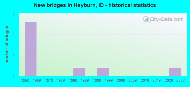
- New bridges - historical statistics
- 131960-1969
- 21980-1989
- 21990-1999
- 22020-2022

- Reconstructed bridges - Historical Statistics
- 21970-1979
- 21980-1989
- 11990-1999
- 02000-2009
- 12010-2019


- Bridge Condition - Deck
- 15.4%Very good
- 38.5%Good
- 38.5%Satisfactory
- 7.7%Fair

- Bridge Condition - Superstructure
- 15.4%Very good
- 7.7%Good
- 53.8%Satisfactory
- 23.1%Fair

- Bridge Condition - Substructure
- 15.4%Very good
- 23.1%Good
- 53.8%Satisfactory
- 7.7%Fair

- Bridge Condition - Channel
- 66.7%Very good
- 33.3%Good
Find on map >> Show street view
Structure Number: 13335, Location: 2.1 N. BURLEY (Lat: 42.568561, Lng: -113.787661), Route carried "on" structure: Ramp Interstate 84, Year Built: 1961, Year Reconstructed: 1979, Status: Open, Structure Length: 7.89m (25.89ft), Average Daily Traffic: 5,500 (year 2019), Truck Traffic: 13%, Average Future Daily Traffic: 8,250 (year 2039), Design Load: HS 20, Features Intersected: I 84B EB-WB;BURLEY IC
Minimum Vertical Clearance: 30+ m (98+ ft), Kilometerpoint: 38.512, Lanes on structure: 2, Lanes under structure: 5, Owner: State Highway Agency, Approaching Roadway Width: 9.1m (29.9ft), Skew: 3 degrees, Material/Design: Prestressed concrete, Design/Construction: Stringer/Multi-beam, Number Of Spans In Main Unit: 3, Number Of Approach Spans: 2, Length of Maximum Span: 21.3m (69.9ft), Curb-To-Curb Width: 8.8m (28.9ft), Out-to-Out Width: 9.5m (31.2ft)
Condition: Deck: Good, Superstructure: Fair, Substructure: Satisfactory, Operating Rating: 59.0 metric tons, Method Used To Determine Operating Rating: Load Factor (LF), Inventory Rating: 35.4 metric tons, Method Used To Determine Inventory Rating: Load Factor (LF), Structural Evaluation: Somewhat better than minimum adequacy, Deck Geometry: Meets minimum limits, Underclear: Meets minimum limits, Approach Roadway Alignment: Equal to present desirable criteria, Length Of Structure Improvement: 8.69m (28.51ft), Designated Inspection Frequency: Every 24 months, Inspection Date: August 2020, Bridge Improvement Cost: $2,304,000, Roadway Improvement Cost: $230,000, Total Project Cost: $3,456,000 ( Estimate for 2020), Deck Structure Type: Concrete Cast-file-Place, Wearing Surface/Protective System: Wearing Surface: Epoxy Overlay
Find on map >> Show street view
Structure Number: 1334, Location: 2.1 N. BURLEY (Lat: 42.567939, Lng: -113.787925), Route carried "on" structure: Ramp Interstate 84, Year Built: 1961, Year Reconstructed: 1979, Status: Open, Structure Length: 7.89m (25.89ft), Average Daily Traffic: 5,500 (year 2019), Truck Traffic: 13%, Average Future Daily Traffic: 8,250 (year 2039), Design Load: HS 20, Features Intersected: I 84B EB-WB;BURLEY IC
Minimum Vertical Clearance: 30+ m (98+ ft), Kilometerpoint: 38.528, Lanes on structure: 2, Lanes under structure: 5, Owner: State Highway Agency, Approaching Roadway Width: 10.4m (34.1ft), Skew: 3 degrees, Material/Design: Prestressed concrete, Design/Construction: Stringer/Multi-beam, Number Of Spans In Main Unit: 3, Number Of Approach Spans: 2, Length of Maximum Span: 21.3m (69.9ft), Curb-To-Curb Width: 8.8m (28.9ft), Out-to-Out Width: 9.5m (31.2ft)
Condition: Deck: Good, Superstructure: Fair, Substructure: Satisfactory, Operating Rating: 58.1 metric tons, Method Used To Determine Operating Rating: Load Factor (LF), Inventory Rating: 34.5 metric tons, Method Used To Determine Inventory Rating: Load Factor (LF), Structural Evaluation: Somewhat better than minimum adequacy, Deck Geometry: Meets minimum limits, Underclear: Meets minimum limits, Approach Roadway Alignment: Equal to present desirable criteria, Length Of Structure Improvement: 8.69m (28.51ft), Designated Inspection Frequency: Every 24 months, Inspection Date: August 2020, Bridge Improvement Cost: $2,304,000, Roadway Improvement Cost: $230,000, Total Project Cost: $3,456,000 ( Estimate for 2020), Deck Structure Type: Concrete Cast-file-Place, Wearing Surface/Protective System: Wearing Surface: Epoxy Overlay
Find on map >> Show street view
Structure Number: 1634, Location: 0.3 W. BURLEY (Lat: 42.568361, Lng: -113.793083), Route carried "on" structure: Interstate 84, Year Built: 1966, Year Reconstructed: 1999, Status: Open, Structure Length: 4.57m (14.99ft), Average Daily Traffic: 10,000 (year 2019), Truck Traffic: 33%, Average Future Daily Traffic: 15,000 (year 2039), Design Load: HS 20, Features Intersected: 'B-4' CANAL
Minimum Vertical Clearance: 30+ m (98+ ft), Kilometerpoint: 334.225, Lanes on structure: 2, Base Highway Network: Yes (Inventory Route: I, Subroute: 2), Owner: State Highway Agency, Approaching Roadway Width: 11.6m (38.1ft), Material/Design: Prestressed concrete, Design/Construction: Stringer/Multi-beam, Number Of Spans In Main Unit: 3, Length of Maximum Span: 14.9m (48.9ft), Curb-To-Curb Width: 11.4m (37.4ft), Out-to-Out Width: 12.3m (40.4ft)
Condition: Deck: Good, Superstructure: Satisfactory, Substructure: Satisfactory, Channel: Very good, Operating Rating: 60.8 metric tons, Method Used To Determine Operating Rating: Load Factor (LF), Inventory Rating: 35.4 metric tons, Method Used To Determine Inventory Rating: Load Factor (LF), Structural Evaluation: Equal to present minimum criteria, Deck Geometry: Somewhat better than minimum adequacy, Waterway Adequacy: Equal to present desirable criteria, Approach Roadway Alignment: Equal to present desirable criteria, Designated Inspection Frequency: Every 48 months, Inspection Date: November 2021, Deck Structure Type: Concrete Cast-file-Place, Wearing Surface/Protective System: Wearing Surface: Epoxy Overlay, Deck Protection: Epoxy Coated Reinforcing
Find on map >> Show street view
Structure Number: 1636, Location: 2.5 E. BURLEY (Lat: 42.568672, Lng: -113.738717), Route carried "on" structure: Interstate 84, Year Built: 1961, Year Reconstructed: 1980, Status: Open, Structure Length: 20.67m (67.81ft), Average Daily Traffic: 9,000 (year 2019), Truck Traffic: 33%, Average Future Daily Traffic: 13,500 (year 2039), Design Load: HS 20, Features Intersected: I 84B; HEYBURN IC
Minimum Vertical Clearance: 30+ m (98+ ft), Kilometerpoint: 338.740, Lanes on structure: 2, Lanes under structure: 5, Base Highway Network: Yes (Inventory Route: I, Subroute: 2), Owner: State Highway Agency, Approaching Roadway Width: 12.2m (40.0ft), Skew: 4 degrees, Material/Design: Prestressed concrete, Design/Construction: Stringer/Multi-beam, Number Of Spans In Main Unit: 9, Length of Maximum Span: 26.2m (86.0ft), Curb-To-Curb Width: 10.4m (34.1ft), Out-to-Out Width: 11.1m (36.4ft)
Condition: Deck: Satisfactory, Superstructure: Satisfactory, Substructure: Satisfactory, Channel: Very good, Operating Rating: 64.4 metric tons, Method Used To Determine Operating Rating: Load Factor (LF), Inventory Rating: 38.1 metric tons, Method Used To Determine Inventory Rating: Load Factor (LF), Structural Evaluation: Equal to present minimum criteria, Deck Geometry: Meets minimum limits, Underclear: High priority of replacement, Waterway Adequacy: Equal to present desirable criteria, Approach Roadway Alignment: Equal to present desirable criteria, Length Of Structure Improvement: 21.49m (70.51ft), Designated Inspection Frequency: Every 48 months, Inspection Date: August 2018, Bridge Improvement Cost: $4,886,000, Roadway Improvement Cost: $487,000, Total Project Cost: $7,329,000 ( Estimate for 2018), Deck Structure Type: Concrete Cast-file-Place, Wearing Surface/Protective System: Wearing Surface: Latex Concrete, Deck Protection: Epoxy Coated Reinforcing
Find on map >> Show street view
Structure Number: 16365, Location: 2.5 E. BURLEY (Lat: 42.568944, Lng: -113.735814), Route carried "on" structure: Interstate 84, Year Built: 1961, Year Reconstructed: 1980, Status: Open, Structure Length: 20.67m (67.81ft), Average Daily Traffic: 9,000 (year 2019), Truck Traffic: 33%, Average Future Daily Traffic: 13,500 (year 2039), Design Load: HS 20, Features Intersected: I 84B; HEYBURN IC
Minimum Vertical Clearance: 30+ m (98+ ft), Kilometerpoint: 338.768, Lanes on structure: 2, Lanes under structure: 5, Base Highway Network: Yes (Inventory Route: I, Subroute: 2), Owner: State Highway Agency, Approaching Roadway Width: 12.2m (40.0ft), Skew: 4 degrees, Material/Design: Prestressed concrete, Design/Construction: Stringer/Multi-beam, Number Of Spans In Main Unit: 9, Length of Maximum Span: 26.2m (86.0ft), Curb-To-Curb Width: 10.4m (34.1ft), Out-to-Out Width: 11.1m (36.4ft)
Condition: Deck: Satisfactory, Superstructure: Satisfactory, Substructure: Satisfactory, Channel: Very good, Operating Rating: 64.4 metric tons, Method Used To Determine Operating Rating: Load Factor (LF), Inventory Rating: 38.1 metric tons, Method Used To Determine Inventory Rating: Load Factor (LF), Structural Evaluation: Equal to present minimum criteria, Deck Geometry: Meets minimum limits, Underclear: High priority of replacement, Waterway Adequacy: Equal to present desirable criteria, Approach Roadway Alignment: Equal to present desirable criteria, Length Of Structure Improvement: 21.49m (70.51ft), Designated Inspection Frequency: Every 48 months, Inspection Date: August 2020, Bridge Improvement Cost: $4,886,000, Roadway Improvement Cost: $487,000, Total Project Cost: $7,329,000 ( Estimate for 2018), Deck Structure Type: Concrete Cast-file-Place, Wearing Surface/Protective System: Wearing Surface: Latex Concrete, Deck Protection: Epoxy Coated Reinforcing
Find on map >> Show street view
Structure Number: 23935, Location: 0.2 S. 5.0 W. DECLO (Lat: 42.512806, Lng: -113.724861), Route carried "on" structure: County highway , Year Built: 1986, Status: Open, Structure Length: 0.67m (2.20ft), Average Daily Traffic: 250 (year 2019), Truck Traffic: 10%, Average Future Daily Traffic: 375 (year 2039), Design Load: HS 20, Features Intersected: 'G' CANAL, Facility Carried by Structure: 350 EAST ROAD
Minimum Vertical Clearance: 30+ m (98+ ft), Kilometerpoint: 170.056, Lanes on structure: 2, Owner: Local Agency, Approaching Roadway Width: 7.3m (24.0ft), Material/Design: Concrete, Design/Construction: Frame, Number Of Spans In Main Unit: 1, Length of Maximum Span: 6.7m (22.0ft), Curb or Sidewalk Widths: Left: 0.3m (1.0ft), Right: 0.3m (1.0ft), Curb-To-Curb Width: 10.5m (34.4ft), Out-to-Out Width: 11.1m (36.4ft)
Condition: Deck: Satisfactory, Superstructure: Satisfactory, Substructure: Good, Channel: Very good, Operating Rating: 34.5 metric tons, Method Used To Determine Operating Rating: Field evaluation and documented engineering judgment, Inventory Rating: 20.9 metric tons, Method Used To Determine Inventory Rating: Field evaluation and documented engineering judgment, Structural Evaluation: Equal to present minimum criteria, Deck Geometry: Better than present minimum criteria, Waterway Adequacy: Equal to present desirable criteria, Approach Roadway Alignment: Equal to present desirable criteria, Designated Inspection Frequency: Every 24 months, Inspection Date: March 2020, Deck Structure Type: Concrete Cast-file-Place, Wearing Surface/Protective System: Wearing Surface: Bituminous
Find on map >> Show street view
Structure Number: 25143, Location: 0.7 S. 3.6 E. HEYBURN (Lat: 42.560444, Lng: -113.705167), Route carried "on" structure: County highway , Year Built: 2020, Status: Open, Structure Length: 0.67m (2.20ft), Average Daily Traffic: 800 (year 2020), Truck Traffic: 24%, Average Future Daily Traffic: 1,200 (year 2040), Design Load: HL 93, Features Intersected: 'A' CANAL, Facility Carried by Structure: 200 WEST ROAD
Minimum Vertical Clearance: 30+ m (98+ ft), Kilometerpoint: 3.608, Lanes on structure: 2, Owner: County Highway Agency, Approaching Roadway Width: 6.7m (22.0ft), Skew: 1 degrees, Material/Design: Concrete, Design/Construction: Frame, Number Of Spans In Main Unit: 1, Length of Maximum Span: 6.2m (20.3ft), Curb or Sidewalk Widths: Left: 0.4m (1.3ft), Right: 0.4m (1.3ft), Curb-To-Curb Width: 10.1m (33.1ft), Out-to-Out Width: 11.0m (36.1ft)
Condition: Deck: Very good, Superstructure: Very good, Substructure: Very good, Channel: Good, Operating Rating: 48.6 metric tons, Method Used To Determine Operating Rating: Load and Resistance Factor Rating (LRFR) rating reported by rating factor(RF) method using HL-93 loadings, Inventory Rating: 37.6 metric tons, Method Used To Determine Inventory Rating: Load and Resistance Factor Rating (LRFR) rating reported by rating factor(RF) method using HL-93 loadings, Structural Evaluation: Equal to present desirable criteria, Deck Geometry: Equal to present minimum criteria, Waterway Adequacy: Equal to present desirable criteria, Approach Roadway Alignment: Equal to present desirable criteria, Designated Inspection Frequency: Every 24 months, Inspection Date: April 2020, Deck Structure Type: Concrete Precast Panels, Wearing Surface/Protective System: Deck Protection: Epoxy Coated Reinforcing
Find on map >> Show street view
Structure Number: 25155, Location: 2.0 S. 2.7 W. RUPERT (Lat: 42.590583, Lng: -113.719389), Route carried "on" structure: County highway , Year Built: 1962, Status: Open, Structure Length: 1.55m (5.09ft), Average Daily Traffic: 200 (year 2019), Truck Traffic: 10%, Average Future Daily Traffic: 300 (year 2039), Design Load: H 15, Features Intersected: 'B-4' CANAL, Facility Carried by Structure: 200 SOUTH ROAD
Minimum Vertical Clearance: 30+ m (98+ ft), Kilometerpoint: 162.998, Lanes on structure: 2, Owner: County Highway Agency, Approaching Roadway Width: 7.3m (24.0ft), Skew: 5 degrees, Material/Design: Prestressed concrete, Design/Construction: Tee Beam, Number Of Spans In Main Unit: 1, Length of Maximum Span: 14.9m (48.9ft), Curb or Sidewalk Widths: Left: 0.3m (1.0ft), Right: 0.3m (1.0ft), Curb-To-Curb Width: 7.3m (24.0ft), Out-to-Out Width: 8.0m (26.2ft)
Condition: Deck: Fair, Superstructure: Fair, Substructure: Fair, Channel: Very good, Operating Rating: 27.2 metric tons, Method Used To Determine Operating Rating: Field evaluation and documented engineering judgment, Inventory Rating: 16.3 metric tons, Method Used To Determine Inventory Rating: Field evaluation and documented engineering judgment, Structural Evaluation: Somewhat better than minimum adequacy, Deck Geometry: Somewhat better than minimum adequacy, Waterway Adequacy: Better than present minimum criteria, Approach Roadway Alignment: Better than present minimum criteria, Length Of Structure Improvement: 2.26m (7.41ft), Designated Inspection Frequency: Every 24 months, Inspection Date: April 2021, Bridge Improvement Cost: $367,000, Roadway Improvement Cost: $37,000, Total Project Cost: $554,000 ( Estimate for 2017), Deck Structure Type: Concrete Precast Panels, Wearing Surface/Protective System: Wearing Surface: Bituminous
Find on map >> Show street view
Structure Number: 25221, Location: 0.7 S. 3.6 E. HEYBURN (Lat: 42.547083, Lng: -113.692417), Route carried "on" structure: County highway , Year Built: 2020, Status: Open, Structure Length: 1.10m (3.61ft), Average Daily Traffic: 1,100 (year 2019), Truck Traffic: 4%, Average Future Daily Traffic: 1,650 (year 2039), Design Load: HL 93, Features Intersected: 'A-5' CANAL, Facility Carried by Structure: 500 SOUTH ROAD
Minimum Vertical Clearance: 30+ m (98+ ft), Kilometerpoint: 5.617, Lanes on structure: 2, Owner: County Highway Agency, Approaching Roadway Width: 7.3m (24.0ft), Skew: 3 degrees, Material/Design: Concrete, Design/Construction: Frame, Number Of Spans In Main Unit: 1, Length of Maximum Span: 10.0m (32.8ft), Curb or Sidewalk Widths: Left: 0.4m (1.3ft), Right: 0.4m (1.3ft), Curb-To-Curb Width: 10.1m (33.1ft), Out-to-Out Width: 11.0m (36.1ft)
Condition: Deck: Very good, Superstructure: Very good, Substructure: Very good, Channel: Good, Operating Rating: 54.1 metric tons, Method Used To Determine Operating Rating: Load and Resistance Factor Rating (LRFR) rating reported by rating factor(RF) method using HL-93 loadings, Inventory Rating: 41.8 metric tons, Method Used To Determine Inventory Rating: Load and Resistance Factor Rating (LRFR) rating reported by rating factor(RF) method using HL-93 loadings, Structural Evaluation: Equal to present desirable criteria, Deck Geometry: Somewhat better than minimum adequacy, Waterway Adequacy: Equal to present desirable criteria, Approach Roadway Alignment: Equal to present desirable criteria, Designated Inspection Frequency: Every 24 months, Inspection Date: April 2020, Deck Structure Type: Concrete Cast-file-Place, Wearing Surface/Protective System: Deck Protection: Epoxy Coated Reinforcing
Find on map >> Show street view
Structure Number: 25255, Location: 2.0 S. 0.8 W. PAUL (Lat: 42.575833, Lng: -113.799444), Route carried "on" structure: County highway , Year Built: 1983, Status: Open, Structure Length: 0.67m (2.20ft), Average Daily Traffic: 200 (year 2019), Truck Traffic: 10%, Average Future Daily Traffic: 300 (year 2039), Design Load: HS 20, Features Intersected: 'B-4' CANAL, Facility Carried by Structure: 300 SOUTH ROAD
Minimum Vertical Clearance: 30+ m (98+ ft), Kilometerpoint: 170.133, Lanes on structure: 2, Owner: County Highway Agency, Approaching Roadway Width: 7.3m (24.0ft), Skew: 5 degrees, Material/Design: Concrete, Design/Construction: Frame, Number Of Spans In Main Unit: 1, Length of Maximum Span: 6.7m (22.0ft), Curb-To-Curb Width: 8.0m (26.2ft), Out-to-Out Width: 12.5m (41.0ft)
Condition: Deck: Satisfactory, Superstructure: Satisfactory, Substructure: Satisfactory, Channel: Good, Operating Rating: 34.5 metric tons, Method Used To Determine Operating Rating: Field evaluation and documented engineering judgment, Inventory Rating: 20.9 metric tons, Method Used To Determine Inventory Rating: Field evaluation and documented engineering judgment, Structural Evaluation: Equal to present minimum criteria, Deck Geometry: Somewhat better than minimum adequacy, Waterway Adequacy: Equal to present desirable criteria, Approach Roadway Alignment: Equal to present desirable criteria, Designated Inspection Frequency: Every 24 months, Inspection Date: March 2020, Deck Structure Type: Concrete Precast Panels, Wearing Surface/Protective System: Wearing Surface: Bituminous
Find on map >> Show street view
Structure Number: 2528, Location: 1.1 S. 3.0 E. PAUL (Lat: 42.590000, Lng: -113.724833), Route carried "on" structure: County highway , Year Built: 1968, Year Reconstructed: 2015, Status: Open, Structure Length: 0.82m (2.69ft), Average Daily Traffic: 100 (year 2019), Truck Traffic: 10%, Average Future Daily Traffic: 150 (year 2039), Design Load: HL 93, Features Intersected: 'B-4' CANAL, Facility Carried by Structure: 300 WEST ROAD
Minimum Vertical Clearance: 30+ m (98+ ft), Kilometerpoint: 177.633, Lanes on structure: 2, Owner: County Highway Agency, Approaching Roadway Width: 7.9m (25.9ft), Material/Design: Concrete, Design/Construction: Slab, Number Of Spans In Main Unit: 1, Length of Maximum Span: 7.9m (25.9ft), Curb-To-Curb Width: 10.2m (33.5ft), Out-to-Out Width: 11.0m (36.1ft)
Condition: Deck: Good, Superstructure: Good, Substructure: Good, Channel: Very good, Operating Rating: 29.5 metric tons, Method Used To Determine Operating Rating: Load and Resistance Factor Rating (LRFR) rating reported by rating factor(RF) method using HL-93 loadings, Inventory Rating: 22.7 metric tons, Method Used To Determine Inventory Rating: Load and Resistance Factor Rating (LRFR) rating reported by rating factor(RF) method using HL-93 loadings, Structural Evaluation: Equal to present minimum criteria, Deck Geometry: Superior to present desirable criteria, Waterway Adequacy: Equal to present desirable criteria, Approach Roadway Alignment: Equal to present desirable criteria, Length Of Structure Improvement: 1.40m (4.59ft), Designated Inspection Frequency: Every 48 months, Inspection Date: April 2021, Bridge Improvement Cost: $274,000, Roadway Improvement Cost: $28,000, Total Project Cost: $411,000 ( Estimate for 2017), Deck Structure Type: Concrete Precast Panels, Wearing Surface/Protective System: Wearing Surface: Bituminous, Deck Protection: Epoxy Coated Reinforcing
Find on map >> Show street view
Structure Number: 25315, Location: 1.2 E. BURLEY (Lat: 42.568056, Lng: -113.763972), Route carried "on" structure: County highway , Year Built: 1961, Status: Open, Structure Length: 6.46m (21.19ft), Average Daily Traffic: 150 (year 2019), Truck Traffic: 10%, Average Future Daily Traffic: 225 (year 2039), Design Load: HS 20, Features Intersected: I 84;500 WEST RD GS, Facility Carried by Structure: 500 WEST ROAD
Minimum Vertical Clearance: 30+ m (98+ ft), Kilometerpoint: 161.642, Lanes on structure: 2, Lanes under structure: 4, Owner: State Highway Agency, Approaching Roadway Width: 7.9m (25.9ft), Material/Design: Prestressed concrete, Design/Construction: Stringer/Multi-beam, Number Of Spans In Main Unit: 3, Number Of Approach Spans: 2, Length of Maximum Span: 14.9m (48.9ft), Curb or Sidewalk Widths: Left: 0.4m (1.3ft), Right: 0.4m (1.3ft), Curb-To-Curb Width: 7.3m (24.0ft), Out-to-Out Width: 8.7m (28.5ft)
Condition: Deck: Satisfactory, Superstructure: Satisfactory, Substructure: Satisfactory, Operating Rating: 49.0 metric tons, Method Used To Determine Operating Rating: Load Factor (LF), Inventory Rating: 29.0 metric tons, Method Used To Determine Inventory Rating: Load Factor (LF), Structural Evaluation: Equal to present minimum criteria, Deck Geometry: Somewhat better than minimum adequacy, Underclear: Meets minimum limits, Approach Roadway Alignment: Equal to present desirable criteria, Length Of Structure Improvement: 7.44m (24.41ft), Designated Inspection Frequency: Every 24 months, Inspection Date: April 2020, Bridge Improvement Cost: $1,127,000, Roadway Improvement Cost: $113,000, Total Project Cost: $1,691,000 ( Estimate for 2020), Deck Structure Type: Concrete Cast-file-Place, Wearing Surface/Protective System: Wearing Surface: Bituminous
Find on map >> Show street view
Structure Number: 2532, Location: 1.0 N. 3.0 E. HEYBURN (Lat: 42.568472, Lng: -113.705167), Route carried "on" structure: County highway , Year Built: 1990, Status: Open, Structure Length: 7.10m (23.29ft), Average Daily Traffic: 150 (year 2019), Truck Traffic: 10%, Average Future Daily Traffic: 225 (year 2039), Design Load: HS 25 or greater, Features Intersected: I 84;200 WEST RD GS, Facility Carried by Structure: 200 WEST ROAD
Minimum Vertical Clearance: 30+ m (98+ ft), Kilometerpoint: 165.360, Lanes on structure: 2, Lanes under structure: 4, Owner: State Highway Agency, Approaching Roadway Width: 7.9m (25.9ft), Material/Design: Prestressed concrete, Design/Construction: Stringer/Multi-beam, Number Of Spans In Main Unit: 2, Length of Maximum Span: 34.7m (113.8ft), Curb-To-Curb Width: 8.7m (28.5ft), Out-to-Out Width: 9.7m (31.8ft)
Condition: Deck: Good, Superstructure: Satisfactory, Substructure: Good, Operating Rating: 89.8 metric tons, Method Used To Determine Operating Rating: Load Factor (LF), Inventory Rating: 36.3 metric tons, Method Used To Determine Inventory Rating: Load Factor (LF), Structural Evaluation: Equal to present minimum criteria, Deck Geometry: Equal to present minimum criteria, Underclear: Equal to present minimum criteria, Approach Roadway Alignment: Equal to present desirable criteria, Designated Inspection Frequency: Every 48 months, Inspection Date: June 2018, Deck Structure Type: Concrete Cast-file-Place, Wearing Surface/Protective System: Wearing Surface: Epoxy Overlay, Deck Protection: Epoxy Coated Reinforcing
Find on map >> Show street view
Structure Number: 13335, Location: 2.1 N. BURLEY (Lat: 42.568561, Lng: -113.787661), Route carried "under" structure: Interstate 84, Year Built: 1961, Structure Length: 0. m, Average Daily Traffic: 17,500 (year 2018), Truck Traffic: 35%, Features Intersected: I 84B EB-WB;BURLEY IC
Minimum Vertical Clearance: 4.95m (16.24ft), Kilometerpoint: 334.720, Lanes on structure: 2, Lanes under structure: 5, Material/Design: Prestressed concrete, Design/Construction: Stringer/Multi-beam, Length of Maximum Span: 21.3m (69.9ft)
Find on map >> Show street view
Structure Number: 1334, Location: 2.1 N. BURLEY (Lat: 42.567939, Lng: -113.787925), Route carried "under" structure: Interstate 84, Year Built: 1961, Structure Length: 0. m, Average Daily Traffic: 19,500 (year 2018), Truck Traffic: 32%, Features Intersected: I 84B EB-WB;BURLEY IC
Minimum Vertical Clearance: 5.00m (16.40ft), Kilometerpoint: 334.710, Lanes on structure: 2, Lanes under structure: 5, Material/Design: Prestressed concrete, Design/Construction: Stringer/Multi-beam, Length of Maximum Span: 21.3m (69.9ft)
Find on map >> Show street view
Structure Number: 1636, Location: 2.5 E. BURLEY (Lat: 42.568672, Lng: -113.738717), Route carried "under" structure: Business Interstate 84, Year Built: 1961, Structure Length: 0. m, Average Daily Traffic: 14,500 (year 2018), Truck Traffic: 6%, Features Intersected: I 84B; HEYBURN IC
Minimum Vertical Clearance: 7.42m (24.34ft), Kilometerpoint: 420.868, Lanes on structure: 2, Lanes under structure: 5, Material/Design: Prestressed concrete, Design/Construction: Stringer/Multi-beam, Length of Maximum Span: 26.2m (86.0ft)
Find on map >> Show street view
Structure Number: 16365, Location: 2.5 E. BURLEY (Lat: 42.568944, Lng: -113.735814), Route carried "under" structure: Business Interstate 84, Year Built: 1961, Structure Length: 0. m, Average Daily Traffic: 14,500 (year 2018), Truck Traffic: 6%, Features Intersected: I 84B; HEYBURN IC
Minimum Vertical Clearance: 7.49m (24.57ft), Kilometerpoint: 420.912, Lanes on structure: 2, Lanes under structure: 5, Material/Design: Prestressed concrete, Design/Construction: Stringer/Multi-beam, Length of Maximum Span: 26.2m (86.0ft)
Find on map >> Show street view
Structure Number: 25315, Location: 1.2 E. BURLEY (Lat: 42.568056, Lng: -113.763972), Route carried "under" structure: Interstate 84, Year Built: 1961, Structure Length: 0. m, Average Daily Traffic: 17,500 (year 2018), Truck Traffic: 34%, Features Intersected: I 84;500 WEST RD GS, Facility Carried by Structure: 500 WEST ROAD
Minimum Vertical Clearance: 5.03m (16.50ft), Kilometerpoint: 336.667, Lanes on structure: 2, Lanes under structure: 4, Material/Design: Prestressed concrete, Design/Construction: Stringer/Multi-beam, Length of Maximum Span: 14.9m (48.9ft)
Find on map >> Show street view
Structure Number: 2532, Location: 1.0 N. 3.0 E. HEYBURN (Lat: 42.568472, Lng: -113.705167), Route carried "under" structure: Interstate 84, Year Built: 1990, Structure Length: 0. m, Average Daily Traffic: 17,000 (year 2018), Truck Traffic: 35%, Features Intersected: I 84;200 WEST RD GS, Facility Carried by Structure: 200 WEST ROAD
Minimum Vertical Clearance: 5.66m (18.57ft), Kilometerpoint: 341.487, Lanes on structure: 2, Lanes under structure: 4, Material/Design: Prestressed concrete, Design/Construction: Stringer/Multi-beam, Length of Maximum Span: 34.7m (113.8ft)