Bridge Statistics for High Ridge, Missouri (MO)
Condition, Traffic, Stress, Structural Evaluation, Project Costs
- National Bridge Inventory (NBI) Statistics
- 23Number of bridges
- 210ft / 63.9mTotal length
- $2,550,000Total costs
- 191,234Total average daily traffic
- 19,778Total average daily truck traffic
- National Bridge Inventory (NBI) Registered Bridges for High Ridge
- No street view available for this location
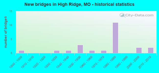
- New bridges - historical statistics
- 11900-1909
- 11930-1939
- 11940-1949
- 31950-1959
- 11960-1969
- 11970-1979
- 111980-1989
- 22000-2009
- 22010-2019

- Reconstructed bridges - Historical Statistics
- 11980-1989
- 11990-1999
- 12000-2009


- Bridge Condition - Deck
- 20.0%Very good
- 30.0%Good
- 40.0%Satisfactory
- 10.0%Fair

- Bridge Condition - Superstructure
- 10.0%Excellent
- 20.0%Very good
- 30.0%Good
- 20.0%Satisfactory
- 10.0%Fair
- 10.0%Poor

- Bridge Condition - Substructure
- 10.0%Excellent
- 50.0%Good
- 30.0%Satisfactory
- 10.0%Fair

- Bridge Condition - Channel
- 40.0%Satisfactory
- 60.0%Fair

- Bridge Condition - Culverts
- 20.0%Good
- 40.0%Satisfactory
- 40.0%Fair
Find on map >> Show street view
Structure Number: 13475, Location: S 32 T 43 N R 5 E (Lat: 38.419525, Lng: -90.483350), Route carried "on" structure: County highway 21, Year Built: 1940, Status: Posted for load, Structure Length: 0.64m (2.10ft), Average Daily Traffic: 4,484 (year 2021), Truck Traffic: 5%, Average Future Daily Traffic: 7,623 (year 2041), Design Load: H 15, Features Intersected: S FK ROCK CR
Minimum Vertical Clearance: 30+ m (98+ ft), Kilometerpoint: 8.449, Lanes on structure: 2, Owner: County Highway Agency, Approaching Roadway Width: 7.3m (24.0ft), Skew: 4 degrees, Material/Design: Concrete, Design/Construction: Culvert, Number Of Spans In Main Unit: 1, Length of Maximum Span: 6.4m (21.0ft), Curb-To-Curb Width: 7.3m (24.0ft), Out-to-Out Width: 7.6m (24.9ft)
Condition: Channel: Fair, Culverts: Fair, Operating Rating: 49.5 metric tons, Method Used To Determine Operating Rating: Allowable Stress (AS), Inventory Rating: 16.2 metric tons, Method Used To Determine Inventory Rating: Allowable Stress (AS), Structural Evaluation: Meets minimum limits, Deck Geometry: High priority of replacement, Waterway Adequacy: Equal to present minimum criteria, Approach Roadway Alignment: Equal to present desirable criteria, Length Of Structure Improvement: 0.13m (0.43ft), Designated Inspection Frequency: Every 24 months, Inspection Date: Febuary 2021, Bridge Improvement Cost: $125,000, Roadway Improvement Cost: $13,000, Total Project Cost: $188,000 ( Estimate for 2022)
Find on map >> Show street view
Structure Number: 13789, Location: S 20 T 43 N R 5 E (Lat: 38.455317, Lng: -90.488983), Route carried "on" structure: County highway , Year Built: 1900, Year Reconstructed: 1995, Status: Posted for load, Structure Length: 1.01m (3.31ft), Average Daily Traffic: 1,100 (year 2021), Truck Traffic: 5%, Average Future Daily Traffic: 1,870 (year 2041), Features Intersected: SUGAR CR, Facility Carried by Structure: OLD SUGAR CREEK RD
Minimum Vertical Clearance: 30+ m (98+ ft), Kilometerpoint: 0.000, Lanes on structure: 2, Owner: County Highway Agency, Approaching Roadway Width: 7.6m (24.9ft), Skew: 3 degrees, Material/Design: Concrete continuous, Design/Construction: Culvert, Number Of Spans In Main Unit: 2, Length of Maximum Span: 4.6m (15.1ft), Curb-To-Curb Width: 8.1m (26.6ft), Out-to-Out Width: 8.6m (28.2ft)
Condition: Channel: Fair, Culverts: Satisfactory, Operating Rating: 54.0 metric tons, Method Used To Determine Operating Rating: Allowable Stress (AS), Inventory Rating: 32.4 metric tons, Method Used To Determine Inventory Rating: Allowable Stress (AS), Structural Evaluation: Equal to present minimum criteria, Deck Geometry: Meets minimum limits, Waterway Adequacy: Better than present minimum criteria, Approach Roadway Alignment: Equal to present minimum criteria, Designated Inspection Frequency: Every 24 months, Inspection Date: Febuary 2021
Find on map >> Show street view
Structure Number: 14222, Location: S 33 T 43 N R 5 E (Lat: 38.426725, Lng: -90.471897), Route carried "on" structure: County highway , Year Built: 1985, Status: Posted for load, Structure Length: 1.22m (4.00ft), Average Daily Traffic: 308 (year 2021), Truck Traffic: 10%, Average Future Daily Traffic: 524 (year 2041), Features Intersected: ROCK CR, Facility Carried by Structure: SWALLER RD
Minimum Vertical Clearance: 30+ m (98+ ft), Kilometerpoint: 0.000, Lanes on structure: 2, Owner: County Highway Agency, Approaching Roadway Width: 6.7m (22.0ft), Skew: 3 degrees, Material/Design: Concrete, Design/Construction: Culvert, Number Of Spans In Main Unit: 1, Length of Maximum Span: 3.7m (12.1ft), Curb-To-Curb Width: 8.7m (28.5ft), Out-to-Out Width: 9.2m (30.2ft)
Condition: Channel: Fair, Culverts: Fair, Operating Rating: 41.4 metric tons, Method Used To Determine Operating Rating: Load Factor (LF), Inventory Rating: 24.3 metric tons, Method Used To Determine Inventory Rating: Load Factor (LF), Structural Evaluation: Somewhat better than minimum adequacy, Deck Geometry: Equal to present minimum criteria, Waterway Adequacy: Equal to present minimum criteria, Approach Roadway Alignment: Meets minimum limits, Designated Inspection Frequency: Every 24 months, Inspection Date: Febuary 2021, Deck Structure Type: Concrete Cast-file-Place, Wearing Surface/Protective System: Wearing Surface: Bituminous
Find on map >> Show street view
Structure Number: 15606, Location: S 33 T 44 N R 4 E (Lat: 38.504550, Lng: -90.561344), Route carried "on" structure: County highway , Year Built: 1960, Year Reconstructed: 2012, Status: Posted for load, Structure Length: 1.68m (5.51ft), Average Daily Traffic: 3,951 (year 2020), Truck Traffic: 6%, Average Future Daily Traffic: 5,334 (year 2040), Design Load: HS 20, Features Intersected: ANTIRE CR, Facility Carried by Structure: BEAUMONT-ANTIRE RD
Minimum Vertical Clearance: 30+ m (98+ ft), Kilometerpoint: 1.770, Lanes on structure: 2, Owner: County Highway Agency, Approaching Roadway Width: 7.6m (24.9ft), Skew: 4 degrees, Material/Design: Prestressed concrete, Design/Construction: Box Beam or Girders - Multiple, Number Of Spans In Main Unit: 1, Length of Maximum Span: 14.0m (45.9ft), Curb or Sidewalk Widths: Left: 0.5m (1.6ft), Right: 0.5m (1.6ft), Curb-To-Curb Width: 7.5m (24.6ft), Out-to-Out Width: 8.3m (27.2ft)
Condition: Deck: Very good, Superstructure: Very good, Substructure: Satisfactory, Channel: Fair, Operating Rating: 70.2 metric tons, Method Used To Determine Operating Rating: Load and Resistance Factor (LRFR), Inventory Rating: 40.5 metric tons, Method Used To Determine Inventory Rating: Load and Resistance Factor (LRFR), Structural Evaluation: Equal to present minimum criteria, Deck Geometry: High priority of replacement, Waterway Adequacy: Better than present minimum criteria, Approach Roadway Alignment: Equal to present minimum criteria, Length Of Structure Improvement: 0.24m (0.79ft), Designated Inspection Frequency: Every 24 months, Inspection Date: March 2021, Bridge Improvement Cost: $206,000, Roadway Improvement Cost: $21,000, Total Project Cost: $309,000 ( Estimate for 2022), Deck Structure Type: Other
Find on map >> Show street view
Structure Number: 2432, Location: S 3 T 34 N R 31 W (Lat: 37.745744, Lng: -94.311644), Route carried "on" structure: Interstate 49, Year Built: 1977, Status: Open, Structure Length: 0.79m (2.59ft), Average Daily Traffic: 11,509 (year 2021), Truck Traffic: 41%, Average Future Daily Traffic: 20,141 (year 2041), Design Load: HS 20, Features Intersected: DRY CR
Minimum Vertical Clearance: 30+ m (98+ ft), Kilometerpoint: 143.425, Lanes on structure: 4, Base Highway Network: Yes, Owner: State Highway Agency, Approaching Roadway Width: 20.1m (65.9ft), Skew: 21 degrees, Material/Design: Concrete continuous, Design/Construction: Culvert, Number Of Spans In Main Unit: 2, Length of Maximum Span: 3.7m (12.1ft)
Condition: Channel: Fair, Culverts: Satisfactory, Operating Rating: 44.1 metric tons, Method Used To Determine Operating Rating: Load Factor (LF), Inventory Rating: 26.1 metric tons, Method Used To Determine Inventory Rating: Load Factor (LF), Structural Evaluation: Equal to present minimum criteria, Waterway Adequacy: Equal to present desirable criteria, Approach Roadway Alignment: Equal to present desirable criteria, Designated Inspection Frequency: Every 24 months, Inspection Date: March 2022
Find on map >> Show street view
Structure Number: 2526, Location: S 5 T 42 N R 5 E (Lat: 38.413114, Lng: -90.491164), Route carried "on" structure: State highway 21, Year Built: 1987, Status: Open, Structure Length: 9.72m (31.89ft), Average Daily Traffic: 8,145 (year 2021), Truck Traffic: 4%, Average Future Daily Traffic: 15,068 (year 2041), Design Load: HS 20, Features Intersected: CRD OLD HWY 21
Minimum Vertical Clearance: 30+ m (98+ ft), Kilometerpoint: 22.075, Lanes on structure: 2, Lanes under structure: 2, Base Highway Network: Yes, Owner: State Highway Agency, Approaching Roadway Width: 12.2m (40.0ft), Skew: 5 degrees, Material/Design: Steel, Design/Construction: Stringer/Multi-beam, Number Of Spans In Main Unit: 4, Length of Maximum Span: 27.1m (88.9ft), Curb or Sidewalk Widths: Left: 0.2m (0.7ft), Right: 0.2m (0.7ft), Curb-To-Curb Width: 12.0m (39.4ft), Out-to-Out Width: 12.8m (42.0ft)
Condition: Deck: Satisfactory, Superstructure: Good, Substructure: Good, Operating Rating: 56.7 metric tons, Method Used To Determine Operating Rating: Load Factor (LF), Inventory Rating: 34.2 metric tons, Method Used To Determine Inventory Rating: Load Factor (LF), Structural Evaluation: Better than present minimum criteria, Deck Geometry: Equal to present minimum criteria, Underclear: Equal to present minimum criteria, Approach Roadway Alignment: Equal to present desirable criteria, Designated Inspection Frequency: Every 24 months, Inspection Date: November 2020, Deck Structure Type: Concrete Cast-file-Place, Wearing Surface/Protective System: Wearing Surface: Bituminous, Deck Protection: Epoxy Coated Reinforcing
Find on map >> Show street view
Structure Number: 2527, Location: S 5 T 42 N R 5 E (Lat: 38.412378, Lng: -90.491383), Route carried "on" structure: State highway 21, Year Built: 1987, Status: Open, Structure Length: 8.41m (27.59ft), Average Daily Traffic: 8,302 (year 2021), Truck Traffic: 7%, Average Future Daily Traffic: 15,359 (year 2041), Design Load: HS 20, Features Intersected: CRD OLD HWY 21
Minimum Vertical Clearance: 30+ m (98+ ft), Kilometerpoint: 290.197, Lanes on structure: 2, Lanes under structure: 3, Base Highway Network: Yes, Owner: State Highway Agency, Approaching Roadway Width: 12.2m (40.0ft), Skew: 4 degrees, Material/Design: Steel, Design/Construction: Stringer/Multi-beam, Number Of Spans In Main Unit: 4, Length of Maximum Span: 24.1m (79.1ft), Curb or Sidewalk Widths: Left: 0.2m (0.7ft), Right: 0.2m (0.7ft), Curb-To-Curb Width: 12.0m (39.4ft), Out-to-Out Width: 12.8m (42.0ft)
Condition: Deck: Satisfactory, Superstructure: Fair, Substructure: Good, Operating Rating: 59.4 metric tons, Method Used To Determine Operating Rating: Load Factor (LF), Inventory Rating: 35.1 metric tons, Method Used To Determine Inventory Rating: Load Factor (LF), Structural Evaluation: Somewhat better than minimum adequacy, Deck Geometry: Equal to present minimum criteria, Underclear: Equal to present minimum criteria, Approach Roadway Alignment: Equal to present desirable criteria, Designated Inspection Frequency: Every 24 months, Inspection Date: November 2020, Deck Structure Type: Concrete Cast-file-Place, Wearing Surface/Protective System: Wearing Surface: Bituminous, Deck Protection: Epoxy Coated Reinforcing
Find on map >> Show street view
Structure Number: 2528, Location: S 7 T 42 N R 5 E (Lat: 38.395314, Lng: -90.502069), Route carried "on" structure: County highway , Year Built: 1988, Status: Open, Structure Length: 9.69m (31.79ft), Average Daily Traffic: 2,719 (year 2021), Truck Traffic: 4%, Average Future Daily Traffic: 4,894 (year 2041), Design Load: HS 20, Features Intersected: MO 21, Facility Carried by Structure: WEST FOUR RIDGE RD
Minimum Vertical Clearance: 30+ m (98+ ft), Kilometerpoint: 6.260, Lanes on structure: 2, Lanes under structure: 4, Owner: State Highway Agency, Approaching Roadway Width: 10.4m (34.1ft), Material/Design: Steel continuous, Design/Construction: Stringer/Multi-beam, Number Of Spans In Main Unit: 2, Length of Maximum Span: 38.5m (126.3ft), Curb or Sidewalk Widths: Left: 0.2m (0.7ft), Right: 0.2m (0.7ft), Curb-To-Curb Width: 10.0m (32.8ft), Out-to-Out Width: 10.8m (35.4ft)
Condition: Deck: Satisfactory, Superstructure: Good, Substructure: Good, Operating Rating: 41.4 metric tons, Method Used To Determine Operating Rating: Load Factor (LF), Inventory Rating: 25.2 metric tons, Method Used To Determine Inventory Rating: Load Factor (LF), Structural Evaluation: Equal to present minimum criteria, Deck Geometry: Meets minimum limits, Underclear: Better than present minimum criteria, Approach Roadway Alignment: Equal to present desirable criteria, Designated Inspection Frequency: Every 24 months, Inspection Date: November 2020, Deck Structure Type: Concrete Cast-file-Place, Wearing Surface/Protective System: Wearing Surface: Monolithic Concrete, Deck Protection: Epoxy Coated Reinforcing
Find on map >> Show street view
Structure Number: 254, Location: S 1974 T 43 N R 5 E (Lat: 38.428667, Lng: -90.470903), Route carried "on" structure: State highway 21, Year Built: 1987, Status: Posted for load, Structure Length: 7.71m (25.30ft), Average Daily Traffic: 9,186 (year 2021), Truck Traffic: 4%, Average Future Daily Traffic: 16,994 (year 2041), Design Load: HS 20, Features Intersected: CRD OLD HWY 21
Minimum Vertical Clearance: 30+ m (98+ ft), Kilometerpoint: 292.776, Lanes on structure: 2, Lanes under structure: 2, Base Highway Network: Yes, Owner: State Highway Agency, Approaching Roadway Width: 12.2m (40.0ft), Skew: 5 degrees, Material/Design: Steel continuous, Design/Construction: Stringer/Multi-beam, Number Of Spans In Main Unit: 3, Length of Maximum Span: 30.8m (101.0ft), Curb or Sidewalk Widths: Left: 0.2m (0.7ft), Right: 0.2m (0.7ft), Curb-To-Curb Width: 12.0m (39.4ft), Out-to-Out Width: 12.8m (42.0ft)
Condition: Deck: Satisfactory, Superstructure: Satisfactory, Substructure: Satisfactory, Operating Rating: 51.3 metric tons, Method Used To Determine Operating Rating: Load Factor (LF), Inventory Rating: 31.5 metric tons, Method Used To Determine Inventory Rating: Load Factor (LF), Structural Evaluation: Equal to present minimum criteria, Deck Geometry: Equal to present minimum criteria, Underclear: Meets minimum limits, Approach Roadway Alignment: Equal to present desirable criteria, Designated Inspection Frequency: Every 24 months, Inspection Date: November 2020, Deck Structure Type: Concrete Cast-file-Place, Wearing Surface/Protective System: Wearing Surface: Bituminous, Deck Protection: Epoxy Coated Reinforcing
Find on map >> Show street view
Structure Number: 31217, Location: S 1974 T 43 N R 5 E (Lat: 38.426703, Lng: -90.474281), Route carried "on" structure: County highway 39, Year Built: 2006, Status: Posted for load, Structure Length: 3.72m (12.20ft), Average Daily Traffic: 5,438 (year 2021), Truck Traffic: 5%, Average Future Daily Traffic: 9,245 (year 2041), Design Load: HS 20, Features Intersected: ROCK CR, Facility Carried by Structure: OLD HWY 21
Minimum Vertical Clearance: 30+ m (98+ ft), Kilometerpoint: 7.355, Lanes on structure: 2, Owner: County Highway Agency, Approaching Roadway Width: 12.2m (40.0ft), Skew: 4 degrees, Material/Design: Steel, Design/Construction: Stringer/Multi-beam, Number Of Spans In Main Unit: 1, Length of Maximum Span: 34.7m (113.8ft), Curb-To-Curb Width: 12.2m (40.0ft), Out-to-Out Width: 13.0m (42.7ft)
Condition: Deck: Good, Superstructure: Satisfactory, Substructure: Good, Channel: Satisfactory, Operating Rating: 81.9 metric tons, Method Used To Determine Operating Rating: Load Factor (LF), Inventory Rating: 38.7 metric tons, Method Used To Determine Inventory Rating: Load Factor (LF), Structural Evaluation: Equal to present minimum criteria, Deck Geometry: Somewhat better than minimum adequacy, Waterway Adequacy: Superior to present desirable criteria, Approach Roadway Alignment: Equal to present desirable criteria, Designated Inspection Frequency: Every 24 months, Inspection Date: Febuary 2021, Deck Structure Type: Concrete Cast-file-Place, Wearing Surface/Protective System: Deck Protection: Epoxy Coated Reinforcing
Find on map >> Show street view
Structure Number: 32415, Location: S 10 T 43 N R 4 E (Lat: 38.479722, Lng: -90.565000), Route carried "on" structure: County highway 14, Year Built: 2004, Status: Posted for load, Structure Length: 1.25m (4.10ft), Average Daily Traffic: 522 (year 2021), Truck Traffic: 10%, Average Future Daily Traffic: 887 (year 2041), Design Load: HS 20, Features Intersected: ANTIRE CR, Facility Carried by Structure: JIM WEBER RD
Minimum Vertical Clearance: 30+ m (98+ ft), Kilometerpoint: 0.000, Lanes on structure: 2, Owner: County Highway Agency, Approaching Roadway Width: 7.3m (24.0ft), Material/Design: Prestressed concrete, Design/Construction: Box Beam or Girders - Multiple, Number Of Spans In Main Unit: 1, Length of Maximum Span: 12.5m (41.0ft), Curb-To-Curb Width: 7.3m (24.0ft), Out-to-Out Width: 7.3m (24.0ft)
Condition: Deck: Very good, Superstructure: Very good, Substructure: Good, Channel: Satisfactory, Operating Rating: 65.7 metric tons, Method Used To Determine Operating Rating: Load Factor (LF), Inventory Rating: 38.7 metric tons, Method Used To Determine Inventory Rating: Load Factor (LF), Structural Evaluation: Better than present minimum criteria, Deck Geometry: Meets minimum limits, Waterway Adequacy: Better than present minimum criteria, Approach Roadway Alignment: Equal to present desirable criteria, Designated Inspection Frequency: Every 24 months, Inspection Date: Febuary 2021, Deck Structure Type: Concrete Precast Panels, Wearing Surface/Protective System: Wearing Surface: Bituminous
Find on map >> Show street view
Structure Number: 33857, Location: S 31 T 43 N R 5 E (Lat: 38.427444, Lng: -90.503333), Route carried "on" structure: County highway , Year Built: 2011, Status: Posted for load, Structure Length: 0.82m (2.69ft), Average Daily Traffic: 800 (year 2021), Truck Traffic: 10%, Average Future Daily Traffic: 1,600 (year 2041), Design Load: HS 20+Mod, Features Intersected: TRIB TO ROCK CR, Facility Carried by Structure: ROCK CR VALLEY RD
Minimum Vertical Clearance: 30+ m (98+ ft), Kilometerpoint: 0.000, Lanes on structure: 2, Owner: County Highway Agency, Approaching Roadway Width: 7.3m (24.0ft), Skew: 5 degrees, Material/Design: Aluminum, Iron, Design/Construction: Culvert, Number Of Spans In Main Unit: 1, Length of Maximum Span: 8.2m (26.9ft), Curb-To-Curb Width: 7.8m (25.6ft), Out-to-Out Width: 9.4m (30.8ft)
Condition: Channel: Satisfactory, Culverts: Good, Operating Rating: 54.0 metric tons, Method Used To Determine Operating Rating: Field evaluation and documented engineering judgment, Inventory Rating: 32.4 metric tons, Method Used To Determine Inventory Rating: Field evaluation and documented engineering judgment, Structural Evaluation: Better than present minimum criteria, Deck Geometry: Meets minimum limits, Waterway Adequacy: Superior to present desirable criteria, Approach Roadway Alignment: Somewhat better than minimum adequacy, Designated Inspection Frequency: Every 24 months, Inspection Date: Febuary 2021
Find on map >> Show street view
Structure Number: 35694, Location: S 13 T 43 N R 4 E (Lat: 38.464722, Lng: -90.512694), Route carried "on" structure: County highway 50, Year Built: 2017, Status: Open, Structure Length: 1.58m (5.18ft), Average Daily Traffic: 1,400 (year 2021), Truck Traffic: 10%, Average Future Daily Traffic: 2,380 (year 2041), Features Intersected: TRIB TO SALINE CR, Facility Carried by Structure: SCHUMACHER RD
Minimum Vertical Clearance: 30+ m (98+ ft), Kilometerpoint: 1.127, Lanes on structure: 2, Owner: County Highway Agency, Approaching Roadway Width: 7.3m (24.0ft), Material/Design: Prestressed concrete, Design/Construction: Box Beam or Girders - Multiple, Number Of Spans In Main Unit: 1, Length of Maximum Span: 14.8m (48.6ft), Curb-To-Curb Width: 9.1m (29.9ft), Out-to-Out Width: 9.1m (29.9ft)
Condition: Deck: Good, Superstructure: Excellent, Substructure: Excellent, Channel: Satisfactory, Operating Rating: 72.0 metric tons, Method Used To Determine Operating Rating: Load Factor (LF), Inventory Rating: 55.8 metric tons, Method Used To Determine Inventory Rating: Load Factor (LF), Structural Evaluation: Superior to present desirable criteria, Deck Geometry: Somewhat better than minimum adequacy, Waterway Adequacy: Superior to present desirable criteria, Approach Roadway Alignment: Meets minimum limits, Designated Inspection Frequency: Every 24 months, Inspection Date: Febuary 2021, Deck Structure Type: Concrete Precast Panels, Wearing Surface/Protective System: Wearing Surface: Monolithic Concrete, Membrane: Built-up, Deck Protection: Epoxy Coated Reinforcing
Find on map >> Show street view
Structure Number: 5937, Location: S 6 T 23 N R 25 W (Lat: 36.732633, Lng: -93.670294), Route carried "on" structure: State highway 39, Year Built: 1938, Status: Posted for load, Structure Length: 7.47m (24.51ft), Average Daily Traffic: 1,881 (year 2021), Truck Traffic: 8%, Average Future Daily Traffic: 3,668 (year 2041), Design Load: H 15, Features Intersected: FLAT CR
Minimum Vertical Clearance: 4.60m (15.09ft), Kilometerpoint: 146.140, Lanes on structure: 2, Base Highway Network: Yes, Owner: State Highway Agency, Approaching Roadway Width: 6.1m (20.0ft), Material/Design: Steel, Design/Construction: Truss - Thru, Number Of Spans In Main Unit: 1, Number Of Approach Spans: 2, Length of Maximum Span: 52.0m (170.6ft), Curb-To-Curb Width: 6.7m (22.0ft), Out-to-Out Width: 7.1m (23.3ft)
Condition: Deck: Fair, Superstructure: Poor, Substructure: Fair, Channel: Fair, Operating Rating: 27.0 metric tons, Method Used To Determine Operating Rating: Allowable Stress (AS), Inventory Rating: 14.4 metric tons, Method Used To Determine Inventory Rating: Allowable Stress (AS), Structural Evaluation: Meets minimum limits, Deck Geometry: High priority of corrective action, Waterway Adequacy: Equal to present desirable criteria, Approach Roadway Alignment: Equal to present desirable criteria, Bridge Posting: Required (Relationship of Operating Rating to Maximum Legal Load: 10.0 - 19.9% below), Length Of Structure Improvement: 0.85m (2.79ft), Designated Inspection Frequency: Every 24 months, Critical Feature Inspection Frequency: Every 24 months, Inspection Date: July 2021, Critical Feature Inspection Date: July 2021, Bridge Improvement Cost: $1,369,000, Roadway Improvement Cost: $137,000, Total Project Cost: $2,053,000 ( Estimate for 2022), Deck Structure Type: Concrete Cast-file-Place, Wearing Surface/Protective System: Wearing Surface: Bituminous
Find on map >> Show street view
Structure Number: 6492, Location: S 34 T 44 N R 4 E (Lat: 38.515297, Lng: -90.549767), Route carried "on" structure: County highway , Year Built: 1958, Year Reconstructed: 1989, Status: Posted for load, Structure Length: 8.17m (26.80ft), Average Daily Traffic: 1,306 (year 2021), Truck Traffic: 5%, Average Future Daily Traffic: 1,959 (year 2041), Design Load: HS 20+Mod, Features Intersected: IS 44, Facility Carried by Structure: BEAUMONT ANTIRE RD
Minimum Vertical Clearance: 30+ m (98+ ft), Kilometerpoint: 0.060, Lanes on structure: 2, Lanes under structure: 7, Owner: State Highway Agency, Approaching Roadway Width: 14.6m (47.9ft), Material/Design: Prestressed concrete continuous, Design/Construction: Stringer/Multi-beam, Number Of Spans In Main Unit: 4, Length of Maximum Span: 26.5m (86.9ft), Curb or Sidewalk Widths: Left: 0.2m (0.7ft), Right: 0.2m (0.7ft), Curb-To-Curb Width: 13.0m (42.7ft), Out-to-Out Width: 13.9m (45.6ft)
Condition: Deck: Good, Superstructure: Good, Substructure: Satisfactory, Operating Rating: 39.6 metric tons, Method Used To Determine Operating Rating: Load Factor (LF), Inventory Rating: 23.4 metric tons, Method Used To Determine Inventory Rating: Load Factor (LF), Structural Evaluation: Equal to present minimum criteria, Deck Geometry: Better than present minimum criteria, Underclear: Equal to present minimum criteria, Approach Roadway Alignment: Equal to present minimum criteria, Designated Inspection Frequency: Every 24 months, Inspection Date: July 2020, Deck Structure Type: Concrete Cast-file-Place, Wearing Surface/Protective System: Wearing Surface: Monolithic Concrete, Deck Protection: Epoxy Coated Reinforcing
Find on map >> Show street view
Structure Number: 2526, Location: S 5 T 42 N R 5 E (Lat: 38.413114, Lng: -90.491164), Route carried "under" structure: County highway , Year Built: 1987, Structure Length: 0. m, Average Daily Traffic: 8,457 (year 2021), Truck Traffic: 5%, Features Intersected: CRD OLD HWY 21, Facility Carried by Structure: MO 21 S
Minimum Vertical Clearance: 5.41m (17.75ft), Kilometerpoint: 6.999, Lanes on structure: 2, Lanes under structure: 2, Material/Design: Steel, Design/Construction: Stringer/Multi-beam, Length of Maximum Span: 27.1m (88.9ft)
Find on map >> Show street view
Structure Number: 2527, Location: S 5 T 42 N R 5 E (Lat: 38.412378, Lng: -90.491383), Route carried "under" structure: County highway , Year Built: 1987, Structure Length: 0. m, Average Daily Traffic: 5,456 (year 2021), Truck Traffic: 6%, Features Intersected: CRD OLD HWY 21, Facility Carried by Structure: MO 21 N
Minimum Vertical Clearance: 5.23m (17.16ft), Kilometerpoint: 7.083, Lanes on structure: 2, Lanes under structure: 3, Material/Design: Steel, Design/Construction: Stringer/Multi-beam, Length of Maximum Span: 24.1m (79.1ft)
Find on map >> Show street view
Structure Number: 2528, Location: S 7 T 42 N R 5 E (Lat: 38.395314, Lng: -90.502069), Route carried "under" structure: State highway 21, Year Built: 1988, Structure Length: 0. m, Average Daily Traffic: 7,613 (year 2021), Truck Traffic: 8%, Features Intersected: MO 21, Facility Carried by Structure: WEST FOUR RIDGE RD
Minimum Vertical Clearance: 9.17m (30.09ft), Kilometerpoint: 24.436, Lanes on structure: 2, Lanes under structure: 2, Material/Design: Steel continuous, Design/Construction: Stringer/Multi-beam, Length of Maximum Span: 38.5m (126.3ft)
Find on map >> Show street view
Structure Number: 2528, Location: S 7 T 42 N R 5 E (Lat: 38.395314, Lng: -90.502069), Route carried "under" structure: State highway 21, Year Built: 1988, Structure Length: 0. m, Average Daily Traffic: 8,302 (year 2021), Truck Traffic: 7%, Features Intersected: MO 21, Facility Carried by Structure: WEST FOUR RIDGE RD
Minimum Vertical Clearance: 9.19m (30.15ft), Kilometerpoint: 288.030, Lanes on structure: 2, Lanes under structure: 2, Material/Design: Steel continuous, Design/Construction: Stringer/Multi-beam, Length of Maximum Span: 38.5m (126.3ft)
Find on map >> Show street view
Structure Number: 254, Location: S 1974 T 43 N R 5 E (Lat: 38.428667, Lng: -90.470903), Route carried "under" structure: County highway , Year Built: 1987, Structure Length: 0. m, Average Daily Traffic: 11,458 (year 2021), Truck Traffic: 5%, Features Intersected: CRD OLD HWY 21, Facility Carried by Structure: MO 21 N
Minimum Vertical Clearance: 6.32m (20.73ft), Kilometerpoint: 4.468, Lanes on structure: 2, Lanes under structure: 2, Material/Design: Steel continuous, Design/Construction: Stringer/Multi-beam, Length of Maximum Span: 30.8m (101.0ft)
Find on map >> Show street view
Structure Number: 2541, Location: S 1974 T 43 N R 5 E (Lat: 38.428494, Lng: -90.471431), Route carried "under" structure: County highway , Year Built: 1987, Structure Length: 0. m, Average Daily Traffic: 11,458 (year 2021), Truck Traffic: 5%, Features Intersected: CRD OLD HWY 21, Facility Carried by Structure: MO 21 S
Minimum Vertical Clearance: 5.03m (16.50ft), Kilometerpoint: 4.516, Lanes on structure: 2, Lanes under structure: 2, Material/Design: Steel continuous, Design/Construction: Stringer/Multi-beam, Length of Maximum Span: 32.9m (107.9ft)
Find on map >> Show street view
Structure Number: 6492, Location: S 34 T 44 N R 4 E (Lat: 38.515297, Lng: -90.549767), Route carried "under" structure: Interstate 44, Year Built: 1958, Structure Length: 0. m, Average Daily Traffic: 41,334 (year 2021), Truck Traffic: 12%, Features Intersected: IS 44, Facility Carried by Structure: BEAUMONT ANTIRE RD
Minimum Vertical Clearance: 5.26m (17.26ft), Kilometerpoint: 39.149, Lanes on structure: 2, Lanes under structure: 3, Material/Design: Prestressed concrete continuous, Design/Construction: Stringer/Multi-beam, Length of Maximum Span: 26.5m (86.9ft)
Find on map >> Show street view
Structure Number: 6492, Location: S 34 T 44 N R 4 E (Lat: 38.515297, Lng: -90.549767), Route carried "under" structure: Interstate 44, Year Built: 1958, Structure Length: 0. m, Average Daily Traffic: 36,105 (year 2021), Truck Traffic: 12%, Features Intersected: IS 44, Facility Carried by Structure: BEAUMONT ANTIRE RD
Minimum Vertical Clearance: 5.11m (16.77ft), Kilometerpoint: 432.578, Lanes on structure: 2, Lanes under structure: 4, Material/Design: Prestressed concrete continuous, Design/Construction: Stringer/Multi-beam, Length of Maximum Span: 26.5m (86.9ft)