Bridge Statistics for Highland Park, Michigan (MI)
Condition, Traffic, Stress, Structural Evaluation, Project Costs
- National Bridge Inventory (NBI) Statistics
- 19Number of bridges
- 180ft / 54.5mTotal length
- $240,000Total costs
- 769,219Total average daily traffic
- 16,897Total average daily truck traffic
- National Bridge Inventory (NBI) Registered Bridges for Highland Park
- No street view available for this location
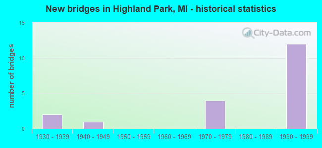
- New bridges - historical statistics
- 21930-1939
- 11940-1949
- 41970-1979
- 121990-1999
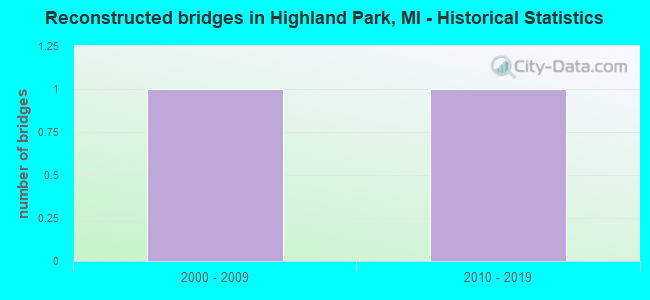
- Reconstructed bridges - Historical Statistics
- 12000-2009
- 12010-2019
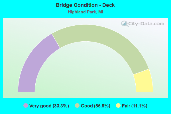
- Bridge Condition - Deck
- 33.3%Very good
- 55.6%Good
- 11.1%Fair
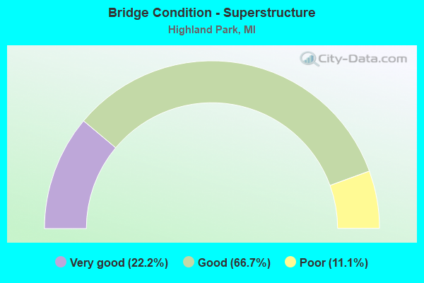
- Bridge Condition - Superstructure
- 22.2%Very good
- 66.7%Good
- 11.1%Poor
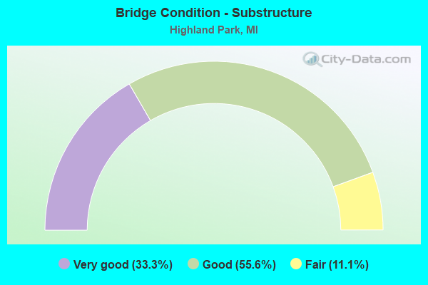
- Bridge Condition - Substructure
- 33.3%Very good
- 55.6%Good
- 11.1%Fair
Find on map >> Show street view
Structure Number: 1137, Location: GIRARD TWP SEC 15-16 (Lat: 42.042964, Lng: -85.001142), Route carried "on" structure: County highway 1265, Year Built: 1930, Status: Open, Structure Length: 0.70m (2.30ft), Average Daily Traffic: 1,950 (year 2004), Truck Traffic: 4%, Average Future Daily Traffic: 2,400 (year 2024), Design Load: H 15, Features Intersected: WARREN BROOK DRAIN 20/31, Facility Carried by Structure: NORTH MARSHALL RD
Minimum Vertical Clearance: 30.48m (100.00ft), Kilometerpoint: 11.367, Lanes on structure: 2, Owner: County Highway Agency, Approaching Roadway Width: 11.0m (36.1ft), Material/Design: Concrete, Design/Construction: Tee Beam, Number Of Spans In Main Unit: 1, Length of Maximum Span: 6.7m (22.0ft), Curb-To-Curb Width: 10.7m (35.1ft), Out-to-Out Width: 11.7m (38.4ft)
Condition: Deck: Fair, Superstructure: Poor, Substructure: Fair, Channel: Satisfactory, Operating Rating: 44.7 metric tons, Method Used To Determine Operating Rating: Field evaluation and documented engineering judgment, Inventory Rating: 26.5 metric tons, Method Used To Determine Inventory Rating: Field evaluation and documented engineering judgment, Structural Evaluation: Meets minimum limits, Deck Geometry: Equal to present minimum criteria, Waterway Adequacy: Equal to present desirable criteria, Approach Roadway Alignment: Equal to present desirable criteria, Length Of Structure Improvement: 1.10m (3.61ft), Designated Inspection Frequency: Every 12 months, Inspection Date: October 2021, Bridge Improvement Cost: $172,000, Roadway Improvement Cost: $20,000, Total Project Cost: $240,000, Deck Structure Type: Concrete Cast-file-Place, Wearing Surface/Protective System: Wearing Surface: Bituminous, Membrane: Other
Find on map >> Show street view
Structure Number: 11368, Location: HIGHLAND PARK E/LODGE FWY (Lat: 42.400011, Lng: -83.104556), Route carried "on" structure: City street , Year Built: 1996, Status: Open, Structure Length: 5.61m (18.41ft), Average Daily Traffic: 26,400 (year 1995), Truck Traffic: 1%, Average Future Daily Traffic: 26,400 (year 2015), Design Load: HS 20, Features Intersected: M-8, DAVISON FWY, Facility Carried by Structure: HAMILTON AVENUE
Minimum Vertical Clearance: 30.48m (100.00ft), Kilometerpoint: 2.274, Lanes on structure: 5, Lanes under structure: 10, Owner: State Highway Agency, Approaching Roadway Width: 21.9m (71.9ft), Material/Design: Prestressed concrete, Design/Construction: Box Beam or Girders - Multiple, Number Of Spans In Main Unit: 2, Length of Maximum Span: 28.0m (91.9ft), Curb or Sidewalk Widths: Left: 2.9m (9.5ft), Right: 2.9m (9.5ft), Curb-To-Curb Width: 24.7m (81.0ft), Out-to-Out Width: 31.5m (103.3ft)
Condition: Deck: Very good, Superstructure: Good, Substructure: Very good, Operating Rating: 70.0 metric tons, Method Used To Determine Operating Rating: Load Factor (LF) rating reported by rating factor (RF) method using MS18 loading, Inventory Rating: 3.6 metric tons, Method Used To Determine Inventory Rating: Load Factor (LF) rating reported by rating factor (RF) method using MS18 loading, Structural Evaluation: High priority of corrective action, Deck Geometry: Superior to present desirable criteria, Underclear: Meets minimum limits, Approach Roadway Alignment: Equal to present desirable criteria, Designated Inspection Frequency: Every 24 months, Inspection Date: October 2021, Deck Structure Type: Concrete Cast-file-Place, Wearing Surface/Protective System: Wearing Surface: Epoxy Overlay, Deck Protection: Epoxy Coated Reinforcing
Find on map >> Show street view
Structure Number: 11369, Location: HIGHLAND PARK E/HAMILTON (Lat: 42.401072, Lng: -83.101461), Route carried "on" structure: City street , Year Built: 1996, Status: Open, Structure Length: 6.48m (21.26ft), Average Daily Traffic: 3,400 (year 1995), Truck Traffic: 5%, Average Future Daily Traffic: 3,400 (year 2015), Design Load: HS 20, Features Intersected: M-8, DAVISON FWY, Facility Carried by Structure: THIRD AVENUE
Minimum Vertical Clearance: 30.48m (100.00ft), Kilometerpoint: 4.106, Lanes on structure: 5, Lanes under structure: 6, Owner: State Highway Agency, Approaching Roadway Width: 12.8m (42.0ft), Material/Design: Prestressed concrete, Design/Construction: Stringer/Multi-beam, Number Of Spans In Main Unit: 2, Length of Maximum Span: 32.4m (106.3ft), Curb or Sidewalk Widths: Left: 1.5m (4.9ft), Right: 1.5m (4.9ft), Curb-To-Curb Width: 11.3m (37.1ft), Out-to-Out Width: 15.3m (50.2ft)
Condition: Deck: Good, Superstructure: Good, Substructure: Good, Operating Rating: 83.3 metric tons, Method Used To Determine Operating Rating: Load Factor (LF) rating reported by rating factor (RF) method using MS18 loading, Inventory Rating: 37.3 metric tons, Method Used To Determine Inventory Rating: Load Factor (LF) rating reported by rating factor (RF) method using MS18 loading, Structural Evaluation: Better than present minimum criteria, Deck Geometry: High priority of replacement, Underclear: High priority of corrective action, Approach Roadway Alignment: Equal to present desirable criteria, Designated Inspection Frequency: Every 24 months, Inspection Date: October 2021, Deck Structure Type: Concrete Cast-file-Place, Wearing Surface/Protective System: Wearing Surface: Epoxy Overlay, Deck Protection: Epoxy Coated Reinforcing
Find on map >> Show street view
Structure Number: 1137, Location: HIGHLAND PARK W/WOODWARD (Lat: 42.401900, Lng: -83.098767), Route carried "on" structure: City street , Year Built: 1996, Status: Open, Structure Length: 7.14m (23.43ft), Average Daily Traffic: 5,500 (year 1995), Truck Traffic: 5%, Average Future Daily Traffic: 14,079 (year 2000), Design Load: HS 20, Features Intersected: M-8, DAVISON FWY, Facility Carried by Structure: SECOND AVENUE
Minimum Vertical Clearance: 30.48m (100.00ft), Kilometerpoint: 1.209, Lanes on structure: 4, Lanes under structure: 10, Owner: State Highway Agency, Approaching Roadway Width: 12.2m (40.0ft), Material/Design: Prestressed concrete, Design/Construction: Box Beam or Girders - Multiple, Number Of Spans In Main Unit: 2, Length of Maximum Span: 37.9m (124.3ft), Curb or Sidewalk Widths: Left: 2.5m (8.2ft), Right: 1.5m (4.9ft), Curb-To-Curb Width: 17.6m (57.7ft), Out-to-Out Width: 22.7m (74.5ft)
Condition: Deck: Good, Superstructure: Good, Substructure: Good, Operating Rating: 54.8 metric tons, Method Used To Determine Operating Rating: Load Factor (LF) rating reported by rating factor (RF) method using MS18 loading, Inventory Rating: 29.2 metric tons, Method Used To Determine Inventory Rating: Load Factor (LF) rating reported by rating factor (RF) method using MS18 loading, Structural Evaluation: Better than present minimum criteria, Deck Geometry: Somewhat better than minimum adequacy, Underclear: High priority of corrective action, Approach Roadway Alignment: Equal to present desirable criteria, Designated Inspection Frequency: Every 24 months, Inspection Date: October 2021, Deck Structure Type: Concrete Cast-file-Place, Wearing Surface/Protective System: Wearing Surface: Epoxy Overlay, Deck Protection: Epoxy Coated Reinforcing
Find on map >> Show street view
Structure Number: 11374, Location: HIGHLAND PARK E/WOODWARD (Lat: 42.404361, Lng: -83.092522), Route carried "on" structure: City street , Year Built: 1996, Status: Open, Structure Length: 6.48m (21.26ft), Average Daily Traffic: 5,600 (year 1995), Truck Traffic: 5%, Average Future Daily Traffic: 5,600 (year 2015), Design Load: HS 20+Mod, Features Intersected: M-8, DAVISON FWY, Facility Carried by Structure: JOHN R STREET
Minimum Vertical Clearance: 30.48m (100.00ft), Kilometerpoint: 2.757, Lanes on structure: 4, Lanes under structure: 10, Owner: State Highway Agency, Approaching Roadway Width: 12.2m (40.0ft), Material/Design: Prestressed concrete, Design/Construction: Stringer/Multi-beam, Number Of Spans In Main Unit: 2, Length of Maximum Span: 32.4m (106.3ft), Curb or Sidewalk Widths: Left: 1.5m (4.9ft), Right: 1.5m (4.9ft), Curb-To-Curb Width: 11.3m (37.1ft), Out-to-Out Width: 15.3m (50.2ft)
Condition: Deck: Very good, Superstructure: Good, Substructure: Very good, Operating Rating: 79.8 metric tons, Method Used To Determine Operating Rating: Load Factor (LF), Inventory Rating: 37.7 metric tons, Method Used To Determine Inventory Rating: Load Factor (LF), Structural Evaluation: Better than present minimum criteria, Deck Geometry: High priority of replacement, Underclear: High priority of corrective action, Approach Roadway Alignment: Equal to present desirable criteria, Designated Inspection Frequency: Every 24 months, Inspection Date: October 2021, Deck Structure Type: Concrete Cast-file-Place, Wearing Surface/Protective System: Wearing Surface: Epoxy Overlay, Deck Protection: Epoxy Coated Reinforcing
Find on map >> Show street view
Structure Number: 11376, Location: IN HIGHLAND PARK (Lat: 42.406375, Lng: -83.086792), Route carried "on" structure: City street 2057, Year Built: 1971, Year Reconstructed: 2015, Status: Open, Structure Length: 8.04m (26.38ft), Average Daily Traffic: 7,000 (year 1970), Truck Traffic: 3%, Average Future Daily Traffic: 7,000 (year 1977), Design Load: HS 20, Features Intersected: M-8, DAVISON FWY, Facility Carried by Structure: SB OAKLAND AVENUE
Minimum Vertical Clearance: 30.48m (100.00ft), Kilometerpoint: 1.700, Lanes on structure: 4, Lanes under structure: 10, Owner: State Highway Agency, Approaching Roadway Width: 15.8m (51.8ft), Material/Design: Steel continuous, Design/Construction: Stringer/Multi-beam, Number Of Spans In Main Unit: 5, Length of Maximum Span: 22.9m (75.1ft), Curb or Sidewalk Widths: Left: 0.0m, Right: 2.4m (7.9ft), Curb-To-Curb Width: 16.0m (52.5ft), Out-to-Out Width: 19.2m (63.0ft)
Condition: Deck: Very good, Superstructure: Very good, Substructure: Good, Operating Rating: 56.4 metric tons, Method Used To Determine Operating Rating: Load Factor (LF) rating reported by rating factor (RF) method using MS18 loading, Inventory Rating: 33.7 metric tons, Method Used To Determine Inventory Rating: Load Factor (LF) rating reported by rating factor (RF) method using MS18 loading, Structural Evaluation: Better than present minimum criteria, Deck Geometry: Meets minimum limits, Underclear: High priority of corrective action, Approach Roadway Alignment: Equal to present desirable criteria, Designated Inspection Frequency: Every 24 months, Inspection Date: October 2021, Deck Structure Type: Concrete Cast-file-Place, Wearing Surface/Protective System: Wearing Surface: Monolithic Concrete, Deck Protection: Epoxy Coated Reinforcing
Find on map >> Show street view
Structure Number: 11381, Location: IN HIGHLAND PARK (Lat: 42.406514, Lng: -83.086419), Route carried "on" structure: City street 2057, Year Built: 1971, Year Reconstructed: 2000, Status: Open, Structure Length: 8.04m (26.38ft), Average Daily Traffic: 6,240 (year 1970), Average Future Daily Traffic: 6,240 (year 1977), Design Load: HS 20, Features Intersected: M-8, DAVISON FWY, Facility Carried by Structure: NB OAKLAND AVENUE
Minimum Vertical Clearance: 30.48m (100.00ft), Kilometerpoint: 4.096, Lanes on structure: 4, Lanes under structure: 10, Owner: State Highway Agency, Approaching Roadway Width: 14.6m (47.9ft), Material/Design: Steel continuous, Design/Construction: Stringer/Multi-beam, Number Of Spans In Main Unit: 5, Length of Maximum Span: 22.9m (75.1ft), Curb or Sidewalk Widths: Left: 0.2m (0.7ft), Right: 2.9m (9.5ft), Curb-To-Curb Width: 15.2m (49.9ft), Out-to-Out Width: 19.2m (63.0ft)
Condition: Deck: Good, Superstructure: Good, Substructure: Good, Operating Rating: 58.6 metric tons, Method Used To Determine Operating Rating: Load Factor (LF) rating reported by rating factor (RF) method using MS18 loading, Inventory Rating: 35.3 metric tons, Method Used To Determine Inventory Rating: Load Factor (LF) rating reported by rating factor (RF) method using MS18 loading, Structural Evaluation: Better than present minimum criteria, Deck Geometry: High priority of corrective action, Underclear: High priority of corrective action, Approach Roadway Alignment: Equal to present desirable criteria, Designated Inspection Frequency: Every 24 months, Inspection Date: October 2021, Deck Structure Type: Concrete Cast-file-Place, Wearing Surface/Protective System: Wearing Surface: Monolithic Concrete, Deck Protection: Other
Find on map >> Show street view
Structure Number: 11615, Location: IN HIGHLAND PARK (Lat: 42.403300, Lng: -83.095556), Route carried "on" structure: State highway 1, Year Built: 1996, Status: Open, Structure Length: 5.88m (19.29ft), Average Daily Traffic: 21,758 (year 2007), Truck Traffic: 3%, Average Future Daily Traffic: 28,595 (year 2018), Design Load: HS 25 or greater, Features Intersected: M-8 DAVISON FWY
Minimum Vertical Clearance: 30.48m (100.00ft), Kilometerpoint: 1.794, Lanes on structure: 8, Lanes under structure: 6, Base Highway Network: Yes (Inventory Route: 159, Subroute: 1), Owner: State Highway Agency, Approaching Roadway Width: 24.7m (81.0ft), Skew: 20 degrees, Material/Design: Prestressed concrete, Design/Construction: Stringer/Multi-beam, Number Of Spans In Main Unit: 2, Length of Maximum Span: 27.5m (90.2ft), Curb or Sidewalk Widths: Left: 3.0m (9.8ft), Right: 3.0m (9.8ft), Curb-To-Curb Width: 24.7m (81.0ft), Out-to-Out Width: 31.7m (104.0ft)
Condition: Deck: Good, Superstructure: Very good, Substructure: Good, Operating Rating: 64.2 metric tons, Method Used To Determine Operating Rating: Load Factor (LF) rating reported by rating factor (RF) method using MS18 loading, Inventory Rating: 33.0 metric tons, Method Used To Determine Inventory Rating: Load Factor (LF) rating reported by rating factor (RF) method using MS18 loading, Structural Evaluation: Better than present minimum criteria, Deck Geometry: High priority of replacement, Underclear: Meets minimum limits, Approach Roadway Alignment: Equal to present desirable criteria, Designated Inspection Frequency: Every 24 months, Inspection Date: November 2021, Deck Structure Type: Concrete Cast-file-Place, Wearing Surface/Protective System: Wearing Surface: Monolithic Concrete, Deck Protection: Epoxy Coated Reinforcing
Find on map >> Show street view
Structure Number: 12667, Location: CITY OF HIGHLAND PARK (Lat: 42.404031, Lng: -83.093633), Route carried "on" structure: State highway 1, Year Built: 1996, Status: Open, Structure Length: 6.17m (20.24ft), Average Daily Traffic: 4,000 (year 1995), Truck Traffic: 5%, Average Future Daily Traffic: 4,000 (year 2015), Design Load: HS 20, Features Intersected: M-8, DAVISON FWY, Facility Carried by Structure: WOODWARD AVE UTURN
Minimum Vertical Clearance: 30.48m (100.00ft), Kilometerpoint: 0.061, Lanes on structure: 2, Lanes under structure: 10, Base Highway Network: Yes (Inventory Route: 470, Subroute: 6), Owner: State Highway Agency, Approaching Roadway Width: 12.8m (42.0ft), Material/Design: Prestressed concrete, Design/Construction: Stringer/Multi-beam, Number Of Spans In Main Unit: 2, Length of Maximum Span: 32.4m (106.3ft), Curb-To-Curb Width: 10.4m (34.1ft), Out-to-Out Width: 11.3m (37.1ft)
Condition: Deck: Good, Superstructure: Good, Substructure: Very good, Operating Rating: 69.3 metric tons, Method Used To Determine Operating Rating: Load Factor (LF) rating reported by rating factor (RF) method using MS18 loading, Inventory Rating: 32.7 metric tons, Method Used To Determine Inventory Rating: Load Factor (LF) rating reported by rating factor (RF) method using MS18 loading, Structural Evaluation: Better than present minimum criteria, Deck Geometry: Somewhat better than minimum adequacy, Underclear: Somewhat better than minimum adequacy, Approach Roadway Alignment: Equal to present desirable criteria, Designated Inspection Frequency: Every 24 months, Inspection Date: November 2021, Deck Structure Type: Concrete Cast-file-Place, Wearing Surface/Protective System: Wearing Surface: Epoxy Overlay, Deck Protection: Epoxy Coated Reinforcing
Find on map >> Show street view
Structure Number: 11368, Location: HIGHLAND PARK E/LODGE FWY (Lat: 42.400011, Lng: -83.104556), Route carried "under" structure: State highway 8, Year Built: 1996, Structure Length: 0. m, Average Daily Traffic: 79,030 (year 2007), Truck Traffic: 2%, Features Intersected: M-8, DAVISON FWY, Facility Carried by Structure: HAMILTON AVENUE
Minimum Vertical Clearance: 5.03m (16.50ft), Kilometerpoint: 4.875, Lanes on structure: 5, Lanes under structure: 10, Material/Design: Prestressed concrete, Design/Construction: Box Beam or Girders - Multiple, Length of Maximum Span: 28.0m (91.9ft)
Find on map >> Show street view
Structure Number: 11369, Location: HIGHLAND PARK E/HAMILTON (Lat: 42.401072, Lng: -83.101461), Route carried "under" structure: State highway 8, Year Built: 1996, Structure Length: 0. m, Average Daily Traffic: 79,030 (year 2007), Truck Traffic: 2%, Features Intersected: M-8, DAVISON FWY, Facility Carried by Structure: THIRD AVENUE
Minimum Vertical Clearance: 4.60m (15.09ft), Kilometerpoint: 5.155, Lanes on structure: 5, Lanes under structure: 6, Material/Design: Prestressed concrete, Design/Construction: Stringer/Multi-beam, Length of Maximum Span: 32.4m (106.3ft)
Find on map >> Show street view
Structure Number: 1137, Location: HIGHLAND PARK W/WOODWARD (Lat: 42.401900, Lng: -83.098767), Route carried "under" structure: State highway 8, Year Built: 1996, Structure Length: 0. m, Average Daily Traffic: 79,030 (year 2007), Truck Traffic: 2%, Features Intersected: M-8, DAVISON FWY, Facility Carried by Structure: SECOND AVENUE
Minimum Vertical Clearance: 4.57m (14.99ft), Kilometerpoint: 5.383, Lanes on structure: 4, Lanes under structure: 10, Material/Design: Prestressed concrete, Design/Construction: Box Beam or Girders - Multiple, Length of Maximum Span: 37.9m (124.3ft)
Find on map >> Show street view
Structure Number: 11374, Location: HIGHLAND PARK E/WOODWARD (Lat: 42.404361, Lng: -83.092522), Route carried "under" structure: State highway 8, Year Built: 1996, Structure Length: 0. m, Average Daily Traffic: 80,714 (year 2007), Truck Traffic: 2%, Features Intersected: M-8, DAVISON FWY, Facility Carried by Structure: JOHN R STREET
Minimum Vertical Clearance: 4.90m (16.08ft), Kilometerpoint: 5.977, Lanes on structure: 4, Lanes under structure: 10, Material/Design: Prestressed concrete, Design/Construction: Stringer/Multi-beam, Length of Maximum Span: 32.4m (106.3ft)
Find on map >> Show street view
Structure Number: 11376, Location: IN HIGHLAND PARK (Lat: 42.406375, Lng: -83.086792), Route carried "under" structure: State highway 8, Year Built: 1971, Structure Length: 0. m, Average Daily Traffic: 80,714 (year 2007), Truck Traffic: 2%, Features Intersected: M-8, DAVISON FWY, Facility Carried by Structure: SB OAKLAND AVENUE
Minimum Vertical Clearance: 4.98m (16.34ft), Kilometerpoint: 6.499, Lanes on structure: 4, Lanes under structure: 10, Material/Design: Steel continuous, Design/Construction: Stringer/Multi-beam, Length of Maximum Span: 22.9m (75.1ft)
Find on map >> Show street view
Structure Number: 11381, Location: IN HIGHLAND PARK (Lat: 42.406514, Lng: -83.086419), Route carried "under" structure: State highway 8, Year Built: 1971, Structure Length: 0. m, Average Daily Traffic: 80,714 (year 2007), Truck Traffic: 2%, Features Intersected: M-8, DAVISON FWY, Facility Carried by Structure: NB OAKLAND AVENUE
Minimum Vertical Clearance: 4.70m (15.42ft), Kilometerpoint: 6.533, Lanes on structure: 4, Lanes under structure: 10, Material/Design: Steel continuous, Design/Construction: Stringer/Multi-beam, Length of Maximum Span: 22.9m (75.1ft)
Find on map >> Show street view
Structure Number: 11615, Location: IN HIGHLAND PARK (Lat: 42.403300, Lng: -83.095556), Route carried "under" structure: State highway 8, Year Built: 1996, Structure Length: 0. m, Average Daily Traffic: 80,714 (year 2007), Truck Traffic: 2%, Features Intersected: M-8 DAVISON FWY, Facility Carried by Structure: M-1 WOODARD AVE
Minimum Vertical Clearance: 4.72m (15.49ft), Kilometerpoint: 5.700, Lanes on structure: 8, Lanes under structure: 6, Material/Design: Prestressed concrete, Design/Construction: Stringer/Multi-beam, Length of Maximum Span: 27.5m (90.2ft)
Find on map >> Show street view
Structure Number: 11618, Location: IN HIGHLAND PARK (Lat: 42.411425, Lng: -83.101047), Route carried "under" structure: State highway 1, Year Built: 1936, Structure Length: 0. m, Average Daily Traffic: 18,797 (year 2007), Truck Traffic: 3%, Features Intersected: M-1, Facility Carried by Structure: CR RR
Minimum Vertical Clearance: 4.52m (14.83ft), Kilometerpoint: 0.784, Lanes under structure: 8, Material/Design: Steel, Design/Construction: Girder and Floorbeam System, Length of Maximum Span: 29.2m (95.8ft)
Find on map >> Show street view
Structure Number: 12092, Location: DETROIT/HIGHLAND PK W/I75 (Lat: 42.418042, Lng: -83.089328), Route carried "under" structure: County highway 2000, Year Built: 1941, Structure Length: 0. m, Average Daily Traffic: 27,914 (year 1997), Truck Traffic: 5%, Features Intersected: SIX MILE ROAD, Facility Carried by Structure: GTW RR
Minimum Vertical Clearance: 4.26m (13.98ft), Kilometerpoint: 0.431, Lanes under structure: 6, Material/Design: Steel, Design/Construction: Girder and Floorbeam System, Length of Maximum Span: 16.1m (52.8ft)
Find on map >> Show street view
Structure Number: 12667, Location: CITY OF HIGHLAND PARK (Lat: 42.404031, Lng: -83.093633), Route carried "under" structure: State highway 8, Year Built: 1996, Structure Length: 0. m, Average Daily Traffic: 80,714 (year 2007), Truck Traffic: 2%, Features Intersected: M-8, DAVISON FWY, Facility Carried by Structure: WOODWARD AVE UTURN
Minimum Vertical Clearance: 5.28m (17.32ft), Kilometerpoint: 1.838, Lanes on structure: 2, Lanes under structure: 10, Material/Design: Prestressed concrete, Design/Construction: Stringer/Multi-beam, Length of Maximum Span: 32.4m (106.3ft)