Bridge Statistics for Hill City, South Dakota (SD)
Condition, Traffic, Stress, Structural Evaluation, Project Costs
- National Bridge Inventory (NBI) Statistics
- 27Number of bridges
- 105ft / 32.3mTotal length
- $476,000Total costs
- 103,665Total average daily traffic
- 8,898Total average daily truck traffic
- National Bridge Inventory (NBI) Registered Bridges for Hill City
- No street view available for this location
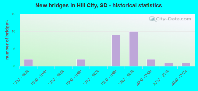
- New bridges - historical statistics
- 21930-1939
- 21960-1969
- 91980-1989
- 101990-1999
- 22000-2009
- 12010-2019
- 12020-2022


- Bridge Condition - Deck
- 7.7%Very good
- 30.8%Good
- 38.5%Satisfactory
- 15.4%Fair
- 7.7%Poor

- Bridge Condition - Superstructure
- 7.7%Very good
- 23.1%Good
- 46.2%Satisfactory
- 15.4%Fair
- 7.7%Poor

- Bridge Condition - Substructure
- 53.8%Good
- 23.1%Satisfactory
- 15.4%Fair
- 7.7%Poor

- Bridge Condition - Channel
- 34.8%Excellent
- 39.1%Very good
- 13.0%Good
- 13.0%Satisfactory

- Bridge Condition - Culverts
- 16.7%Very good
- 16.7%Good
- 66.7%Satisfactory
Find on map >> Show street view
Structure Number: 52221445, Location: 1.6 N OF CUSTER CO LINE (Lat: 43.875197, Lng: -103.614794), Route carried "on" structure: US 16, Year Built: 1998, Status: Open, Structure Length: 0.70m (2.30ft), Average Daily Traffic: 6,855 (year 2021), Truck Traffic: 15%, Average Future Daily Traffic: 10,810 (year 2041), Design Load: HS 20+Mod, Features Intersected: SPRING CK
Minimum Vertical Clearance: 30+ m (98+ ft), Kilometerpoint: 57.454, Lanes on structure: 2, Owner: State Highway Agency, Approaching Roadway Width: 13.4m (44.0ft), Material/Design: Concrete continuous, Design/Construction: Culvert, Number Of Spans In Main Unit: 2, Length of Maximum Span: 3.4m (11.2ft)
Condition: Channel: Excellent, Culverts: Satisfactory, Inventory Rating: 91.3 metric tons, Method Used To Determine Inventory Rating: Load Factor (LF), Structural Evaluation: Equal to present minimum criteria, Waterway Adequacy: Superior to present desirable criteria, Approach Roadway Alignment: Superior to present desirable criteria, Designated Inspection Frequency: Every 48 months, Inspection Date: April 2020
Find on map >> Show street view
Structure Number: 52224439, Location: 2.4 N OF CUSTER CO LINE (Lat: 43.884239, Lng: -103.605464), Route carried "on" structure: US 16, Year Built: 1996, Status: Open, Structure Length: 0.76m (2.49ft), Average Daily Traffic: 6,855 (year 2021), Truck Traffic: 15%, Average Future Daily Traffic: 10,810 (year 2041), Design Load: HS 20+Mod, Features Intersected: SPRING CK
Minimum Vertical Clearance: 30+ m (98+ ft), Kilometerpoint: 58.725, Lanes on structure: 2, Owner: State Highway Agency, Approaching Roadway Width: 13.4m (44.0ft), Skew: 1 degrees, Material/Design: Concrete continuous, Design/Construction: Culvert, Number Of Spans In Main Unit: 2, Length of Maximum Span: 3.7m (12.1ft)
Condition: Channel: Excellent, Culverts: Satisfactory, Operating Rating: 89.8 metric tons, Method Used To Determine Operating Rating: Load Factor (LF), Inventory Rating: 70.9 metric tons, Method Used To Determine Inventory Rating: Load Factor (LF), Structural Evaluation: Equal to present minimum criteria, Waterway Adequacy: Superior to present desirable criteria, Approach Roadway Alignment: Equal to present desirable criteria, Designated Inspection Frequency: Every 24 months, Inspection Date: March 2020
Find on map >> Show street view
Structure Number: 52226438, Location: 2.5 N OF CUSTER CO LINE (Lat: 43.885408, Lng: -103.601406), Route carried "on" structure: US 16, Year Built: 1998, Status: Open, Structure Length: 0.75m (2.46ft), Average Daily Traffic: 6,855 (year 2021), Truck Traffic: 15%, Average Future Daily Traffic: 10,810 (year 2041), Design Load: HS 20+Mod, Features Intersected: SPRING CK
Minimum Vertical Clearance: 30+ m (98+ ft), Kilometerpoint: 59.079, Lanes on structure: 2, Owner: State Highway Agency, Approaching Roadway Width: 13.4m (44.0ft), Material/Design: Concrete continuous, Design/Construction: Culvert, Number Of Spans In Main Unit: 2, Length of Maximum Span: 3.7m (12.1ft)
Condition: Channel: Excellent, Culverts: Satisfactory, Operating Rating: 89.8 metric tons, Method Used To Determine Operating Rating: Load Factor (LF), Inventory Rating: 83.1 metric tons, Method Used To Determine Inventory Rating: Load Factor (LF), Structural Evaluation: Equal to present minimum criteria, Waterway Adequacy: Superior to present desirable criteria, Approach Roadway Alignment: Equal to present desirable criteria, Designated Inspection Frequency: Every 48 months, Inspection Date: April 2020
Find on map >> Show street view
Structure Number: 52231439, Location: 3.0 N OF CUSTER CO LINE (Lat: 43.884128, Lng: -103.595664), Route carried "on" structure: US 16, Year Built: 1998, Status: Open, Structure Length: 0.77m (2.53ft), Average Daily Traffic: 6,855 (year 2021), Truck Traffic: 15%, Average Future Daily Traffic: 10,810 (year 2041), Design Load: HS 20+Mod, Features Intersected: SPRING CK
Minimum Vertical Clearance: 30+ m (98+ ft), Kilometerpoint: 59.578, Lanes on structure: 2, Owner: State Highway Agency, Approaching Roadway Width: 13.4m (44.0ft), Skew: 1 degrees, Material/Design: Concrete continuous, Design/Construction: Culvert, Number Of Spans In Main Unit: 2, Length of Maximum Span: 3.7m (12.1ft)
Condition: Channel: Excellent, Culverts: Satisfactory, Inventory Rating: 91.6 metric tons, Method Used To Determine Inventory Rating: Load Factor (LF), Structural Evaluation: Equal to present minimum criteria, Waterway Adequacy: Superior to present desirable criteria, Approach Roadway Alignment: Equal to present desirable criteria, Designated Inspection Frequency: Every 48 months, Inspection Date: April 2020
Find on map >> Show street view
Structure Number: 52232439, Location: 3.1 N CUSTER CO LINE (Lat: 43.885050, Lng: -103.593389), Route carried "on" structure: US 16, Year Built: 1998, Status: Open, Structure Length: 0.75m (2.46ft), Average Daily Traffic: 6,855 (year 2021), Truck Traffic: 15%, Average Future Daily Traffic: 10,810 (year 2041), Design Load: HS 20+Mod, Features Intersected: SPRING CK
Minimum Vertical Clearance: 30+ m (98+ ft), Kilometerpoint: 59.803, Lanes on structure: 2, Owner: State Highway Agency, Approaching Roadway Width: 13.4m (44.0ft), Material/Design: Concrete continuous, Design/Construction: Culvert, Number Of Spans In Main Unit: 2, Length of Maximum Span: 3.7m (12.1ft)
Condition: Channel: Excellent, Culverts: Satisfactory, Inventory Rating: 91.4 metric tons, Method Used To Determine Inventory Rating: Load Factor (LF), Structural Evaluation: Equal to present minimum criteria, Waterway Adequacy: Superior to present desirable criteria, Approach Roadway Alignment: Better than present minimum criteria, Designated Inspection Frequency: Every 48 months, Inspection Date: April 2020
Find on map >> Show street view
Structure Number: 52236392, Location: .3W & .9N HILL CITY (Lat: 43.952175, Lng: -103.585936), Route carried "on" structure: County highway , Year Built: 1987, Status: Open, Structure Length: 0.76m (2.49ft), Average Daily Traffic: 537 (year 2019), Truck Traffic: 3%, Average Future Daily Traffic: 537 (year 2032), Design Load: HS 20+Mod, Features Intersected: NEWTON FORK CK, Facility Carried by Structure: DEERFIELD ROAD
Minimum Vertical Clearance: 30+ m (98+ ft), Kilometerpoint: 0.000, Lanes on structure: 2, Owner: County Highway Agency, Approaching Roadway Width: 7.3m (24.0ft), Material/Design: Prestressed concrete, Design/Construction: Tee Beam, Number Of Spans In Main Unit: 1, Length of Maximum Span: 7.3m (24.0ft), Curb-To-Curb Width: 9.8m (32.2ft), Out-to-Out Width: 10.5m (34.4ft)
Condition: Deck: Satisfactory, Superstructure: Satisfactory, Substructure: Satisfactory, Channel: Satisfactory, Operating Rating: 65.5 metric tons, Method Used To Determine Operating Rating: Load Factor (LF), Inventory Rating: 39.2 metric tons, Method Used To Determine Inventory Rating: Load Factor (LF), Structural Evaluation: Equal to present minimum criteria, Deck Geometry: Equal to present minimum criteria, Waterway Adequacy: Equal to present minimum criteria, Approach Roadway Alignment: Better than present minimum criteria, Designated Inspection Frequency: Every 24 months, Inspection Date: September 2020, Deck Structure Type: Concrete Precast Panels, Wearing Surface/Protective System: Wearing Surface: Bituminous
Find on map >> Show street view
Structure Number: 52239394, Location: .3W & .8N HILL CITY (Lat: 43.948092, Lng: -103.581631), Route carried "on" structure: County highway , Year Built: 1987, Status: Open, Structure Length: 0.76m (2.49ft), Average Daily Traffic: 537 (year 2019), Truck Traffic: 3%, Average Future Daily Traffic: 537 (year 2032), Design Load: HS 20+Mod, Features Intersected: NEWTON FORK CK, Facility Carried by Structure: DEERFIELD ROAD
Minimum Vertical Clearance: 30+ m (98+ ft), Kilometerpoint: 0.000, Lanes on structure: 2, Owner: County Highway Agency, Approaching Roadway Width: 7.3m (24.0ft), Material/Design: Prestressed concrete, Design/Construction: Tee Beam, Number Of Spans In Main Unit: 1, Length of Maximum Span: 7.3m (24.0ft), Curb-To-Curb Width: 9.8m (32.2ft), Out-to-Out Width: 10.5m (34.4ft)
Condition: Deck: Satisfactory, Superstructure: Satisfactory, Substructure: Good, Channel: Satisfactory, Operating Rating: 65.5 metric tons, Method Used To Determine Operating Rating: Load Factor (LF), Inventory Rating: 39.2 metric tons, Method Used To Determine Inventory Rating: Load Factor (LF), Structural Evaluation: Equal to present minimum criteria, Deck Geometry: Equal to present minimum criteria, Waterway Adequacy: Equal to present minimum criteria, Approach Roadway Alignment: Superior to present desirable criteria, Designated Inspection Frequency: Every 24 months, Inspection Date: September 2020, Deck Structure Type: Concrete Precast Panels, Wearing Surface/Protective System: Wearing Surface: Bituminous
Find on map >> Show street view
Structure Number: 52239411, Location: 0.5M S & 0.5M W HILL CITY (Lat: 43.920333, Lng: -103.584058), Route carried "on" structure: ServiceUS 16, Year Built: 1980, Year Reconstructed: 2002, Status: Open, Structure Length: 0.77m (2.53ft), Average Daily Traffic: 10 (year 2020), Truck Traffic: 3%, Average Future Daily Traffic: 15 (year 2040), Design Load: HS 20, Features Intersected: SPRING CK
Minimum Vertical Clearance: 30+ m (98+ ft), Kilometerpoint: 64.261, Lanes on structure: 1, Owner: State Highway Agency, Approaching Roadway Width: 4.3m (14.1ft), Material/Design: Steel, Design/Construction: Stringer/Multi-beam, Number Of Spans In Main Unit: 1, Length of Maximum Span: 7.1m (23.3ft), Curb or Sidewalk Widths: Left: 0.2m (0.7ft), Right: 0.2m (0.7ft), Curb-To-Curb Width: 4.3m (14.1ft), Out-to-Out Width: 4.7m (15.4ft)
Condition: Deck: Good, Superstructure: Satisfactory, Substructure: Good, Channel: Good, Operating Rating: 80.2 metric tons, Method Used To Determine Operating Rating: Load Factor (LF), Inventory Rating: 48.0 metric tons, Method Used To Determine Inventory Rating: Load Factor (LF), Structural Evaluation: Equal to present minimum criteria, Deck Geometry: Equal to present minimum criteria, Waterway Adequacy: Better than present minimum criteria, Approach Roadway Alignment: Equal to present desirable criteria, Designated Inspection Frequency: Every 24 months, Inspection Date: December 2020, Deck Structure Type: Wood or Timber, Wearing Surface/Protective System: Wearing Surface: Wood or Timber
Find on map >> Show street view
Structure Number: 52242403, Location: OLD HWY16-N EDGE TOWN- HC (Lat: 43.936053, Lng: -103.571750), Route carried "on" structure: City street , Year Built: 1930, Status: Posted for load, Structure Length: 3.08m (10.10ft), Average Daily Traffic: 1,000 (year 2019), Truck Traffic: 9%, Average Future Daily Traffic: 1,368 (year 2032), Design Load: HS 20+Mod, Features Intersected: ABANDON LINE RR, Facility Carried by Structure: TOWN STREET (US16)
Minimum Vertical Clearance: 30+ m (98+ ft), Kilometerpoint: 0.000, Lanes on structure: 2, Owner: Town or Township Highway Agency, Approaching Roadway Width: 7.3m (24.0ft), Material/Design: Steel continuous, Design/Construction: Stringer/Multi-beam, Number Of Spans In Main Unit: 3, Length of Maximum Span: 10.1m (33.1ft), Curb-To-Curb Width: 6.1m (20.0ft), Out-to-Out Width: 6.9m (22.6ft)
Condition: Deck: Poor, Superstructure: Poor, Substructure: Poor, Operating Rating: 24.5 metric tons, Method Used To Determine Operating Rating: Load Factor (LF), Inventory Rating: 18.3 metric tons, Method Used To Determine Inventory Rating: Load Factor (LF), Structural Evaluation: Meets minimum limits, Deck Geometry: High priority of corrective action, Underclear: Equal to present minimum criteria, Approach Roadway Alignment: Meets minimum limits, Bridge Posting: Required (Relationship of Operating Rating to Maximum Legal Load: 20.0 - 29.9% below), Length Of Structure Improvement: 3.66m (12.01ft), Designated Inspection Frequency: Every 24 months, Critical Feature Inspection Frequency: Every 24 months, Inspection Date: August 2020, Critical Feature Inspection Date: August 2020, Bridge Improvement Cost: $338,000, Roadway Improvement Cost: $34,000, Total Project Cost: $476,000, Deck Structure Type: Concrete Cast-file-Place, Wearing Surface/Protective System: Wearing Surface: Bituminous, Membrane: Preformed Fabric
Find on map >> Show street view
Structure Number: 52243404, Location: 200' EAST NEWTON ST (Lat: 43.934528, Lng: -103.572000), Route carried "on" structure: US 16, Year Built: 1995, Status: Open, Structure Length: 1.17m (3.84ft), Average Daily Traffic: 7,418 (year 2021), Truck Traffic: 4%, Average Future Daily Traffic: 11,698 (year 2041), Design Load: HS 25 or greater, Features Intersected: SPRING CK
Minimum Vertical Clearance: 30+ m (98+ ft), Kilometerpoint: 66.225, Lanes on structure: 2, Owner: State Highway Agency, Approaching Roadway Width: 14.6m (47.9ft), Material/Design: Concrete, Design/Construction: Frame, Number Of Spans In Main Unit: 1, Length of Maximum Span: 10.7m (35.1ft), Curb or Sidewalk Widths: Left: 3.7m (12.1ft), Right: 3.7m (12.1ft), Curb-To-Curb Width: 15.2m (49.9ft), Out-to-Out Width: 23.2m (76.1ft)
Condition: Deck: Satisfactory, Superstructure: Satisfactory, Substructure: Good, Channel: Very good, Operating Rating: 49.4 metric tons, Method Used To Determine Operating Rating: Load and Resistance Factor (LRFR), Inventory Rating: 38.2 metric tons, Method Used To Determine Inventory Rating: Load and Resistance Factor (LRFR), Structural Evaluation: Equal to present minimum criteria, Deck Geometry: Superior to present desirable criteria, Waterway Adequacy: Equal to present desirable criteria, Approach Roadway Alignment: Superior to present desirable criteria, Designated Inspection Frequency: Every 24 months, Inspection Date: December 2021, Deck Structure Type: Concrete Cast-file-Place, Wearing Surface/Protective System: Wearing Surface: Epoxy Overlay, Membrane: Epoxy, Deck Protection: Epoxy Coated Reinforcing
Find on map >> Show street view
Structure Number: 52244404, Location: 0.3E & 0.3N HILL CITY (Lat: 43.934908, Lng: -103.568683), Route carried "on" structure: US 16, Year Built: 1995, Status: Open, Structure Length: 1.22m (4.00ft), Average Daily Traffic: 7,418 (year 2021), Truck Traffic: 4%, Average Future Daily Traffic: 11,698 (year 2041), Design Load: HS 25 or greater, Features Intersected: SPRING CK
Minimum Vertical Clearance: 30+ m (98+ ft), Kilometerpoint: 66.498, Lanes on structure: 2, Owner: State Highway Agency, Approaching Roadway Width: 14.6m (47.9ft), Skew: 1 degrees, Material/Design: Concrete, Design/Construction: Frame, Number Of Spans In Main Unit: 1, Length of Maximum Span: 11.0m (36.1ft), Curb or Sidewalk Widths: Left: 3.7m (12.1ft), Right: 3.7m (12.1ft), Curb-To-Curb Width: 14.6m (47.9ft), Out-to-Out Width: 22.6m (74.1ft)
Condition: Deck: Good, Superstructure: Good, Substructure: Good, Channel: Very good, Operating Rating: 50.6 metric tons, Method Used To Determine Operating Rating: Load and Resistance Factor (LRFR), Inventory Rating: 38.8 metric tons, Method Used To Determine Inventory Rating: Load and Resistance Factor (LRFR), Structural Evaluation: Better than present minimum criteria, Deck Geometry: Superior to present desirable criteria, Waterway Adequacy: Superior to present desirable criteria, Approach Roadway Alignment: Superior to present desirable criteria, Designated Inspection Frequency: Every 24 months, Inspection Date: December 2021, Deck Structure Type: Concrete Cast-file-Place, Wearing Surface/Protective System: Wearing Surface: Epoxy Overlay, Membrane: Epoxy, Deck Protection: Epoxy Coated Reinforcing
Find on map >> Show street view
Structure Number: 52245404, Location: MAJOR LK RD - HILL CITY (Lat: 43.935694, Lng: -103.567883), Route carried "on" structure: County highway , Year Built: 2021, Status: Open, Structure Length: 0.96m (3.15ft), Average Daily Traffic: 917 (year 2019), Truck Traffic: 2%, Average Future Daily Traffic: 917 (year 2032), Design Load: HL 93, Features Intersected: MAJOR LAKE SPILLWAY, Facility Carried by Structure: MAJOR LAKE ROAD
Minimum Vertical Clearance: 30+ m (98+ ft), Kilometerpoint: 0.000, Lanes on structure: 2, Owner: Town or Township Highway Agency, Approaching Roadway Width: 7.3m (24.0ft), Skew: 2 degrees, Material/Design: Concrete continuous, Design/Construction: Culvert, Number Of Spans In Main Unit: 2, Length of Maximum Span: 4.7m (15.4ft), Curb or Sidewalk Widths: Left: 2.4m (7.9ft), Right: 0.0m, Out-to-Out Width: 9.8m (32.2ft)
Condition: Channel: Excellent, Culverts: Very good, Operating Rating: 48.1 metric tons, Method Used To Determine Operating Rating: Load and Resistance Factor (LRFR), Inventory Rating: 37.2 metric tons, Method Used To Determine Inventory Rating: Load and Resistance Factor (LRFR), Structural Evaluation: Equal to present desirable criteria, Waterway Adequacy: Superior to present desirable criteria, Approach Roadway Alignment: Superior to present desirable criteria, Designated Inspection Frequency: Every 24 months, Inspection Date: Febuary 2022
Find on map >> Show street view
Structure Number: 52245405, Location: 0.3N & 0.4E HILL CITY (Lat: 43.935031, Lng: -103.567881), Route carried "on" structure: US 16, Year Built: 1995, Status: Open, Structure Length: 0.67m (2.20ft), Average Daily Traffic: 7,418 (year 2021), Truck Traffic: 4%, Average Future Daily Traffic: 11,698 (year 2041), Design Load: HS 20+Mod, Features Intersected: NEWTON FORK CK
Minimum Vertical Clearance: 30+ m (98+ ft), Kilometerpoint: 66.562, Lanes on structure: 2, Owner: State Highway Agency, Approaching Roadway Width: 14.6m (47.9ft), Skew: 2 degrees, Material/Design: Concrete continuous, Design/Construction: Culvert, Number Of Spans In Main Unit: 2, Length of Maximum Span: 3.2m (10.5ft)
Condition: Channel: Very good, Culverts: Good, Operating Rating: 51.1 metric tons, Method Used To Determine Operating Rating: Load Factor (LF), Inventory Rating: 30.6 metric tons, Method Used To Determine Inventory Rating: Load Factor (LF), Structural Evaluation: Better than present minimum criteria, Waterway Adequacy: Equal to present desirable criteria, Approach Roadway Alignment: Superior to present desirable criteria, Designated Inspection Frequency: Every 24 months, Inspection Date: December 2021
Find on map >> Show street view
Structure Number: 52256401, Location: 1.2 E OF HILL CITY (Lat: 43.940258, Lng: -103.546197), Route carried "on" structure: US 16, Year Built: 1986, Status: Open, Structure Length: 3.26m (10.70ft), Average Daily Traffic: 6,892 (year 2021), Truck Traffic: 5%, Average Future Daily Traffic: 10,869 (year 2041), Design Load: HS 20+Mod, Features Intersected: SPRING CK
Minimum Vertical Clearance: 30+ m (98+ ft), Kilometerpoint: 68.622, Lanes on structure: 2, Owner: State Highway Agency, Approaching Roadway Width: 13.4m (44.0ft), Material/Design: Steel, Design/Construction: Stringer/Multi-beam, Number Of Spans In Main Unit: 1, Length of Maximum Span: 32.0m (105.0ft), Curb-To-Curb Width: 13.4m (44.0ft), Out-to-Out Width: 14.2m (46.6ft)
Condition: Deck: Satisfactory, Superstructure: Satisfactory, Substructure: Good, Channel: Very good, Operating Rating: 89.8 metric tons, Method Used To Determine Operating Rating: Load Factor (LF), Inventory Rating: 60.5 metric tons, Method Used To Determine Inventory Rating: Load Factor (LF), Structural Evaluation: Equal to present minimum criteria, Deck Geometry: Equal to present minimum criteria, Waterway Adequacy: Equal to present desirable criteria, Approach Roadway Alignment: Equal to present minimum criteria, Designated Inspection Frequency: Every 24 months, Inspection Date: November 2021, Deck Structure Type: Concrete Cast-file-Place, Wearing Surface/Protective System: Wearing Surface: Epoxy Overlay, Membrane: Epoxy, Deck Protection: Epoxy Coated Reinforcing
Find on map >> Show street view
Structure Number: 52256434, Location: 1.4E 2.7S HILL CITY (Lat: 43.891292, Lng: -103.549222), Route carried "on" structure: County highway , Year Built: 2009, Status: Open, Structure Length: 1.29m (4.23ft), Average Daily Traffic: 106 (year 2019), Truck Traffic: 2%, Average Future Daily Traffic: 106 (year 2032), Features Intersected: PALMER CK RD, Facility Carried by Structure: PALMER GULCH RD
Minimum Vertical Clearance: 30+ m (98+ ft), Kilometerpoint: 0.000, Lanes on structure: 2, Lanes under structure: 2, Owner: County Highway Agency, Approaching Roadway Width: 4.1m (13.5ft), Skew: 3 degrees, Material/Design: Wood or Timber, Design/Construction: Slab, Number Of Spans In Main Unit: 1, Length of Maximum Span: 12.2m (40.0ft), Curb-To-Curb Width: 4.1m (13.5ft), Out-to-Out Width: 4.9m (16.1ft)
Condition: Deck: Very good, Superstructure: Very good, Substructure: Good, Operating Rating: 32.7 metric tons, Method Used To Determine Operating Rating: Field evaluation and documented engineering judgment, Inventory Rating: 24.5 metric tons, Method Used To Determine Inventory Rating: Field evaluation and documented engineering judgment, Structural Evaluation: Equal to present minimum criteria, Deck Geometry: High priority of replacement, Underclear: High priority of corrective action, Approach Roadway Alignment: Superior to present desirable criteria, Designated Inspection Frequency: Every 24 months, Inspection Date: June 2021, Deck Structure Type: Wood or Timber, Wearing Surface/Protective System: Wearing Surface: Wood or Timber
Find on map >> Show street view
Structure Number: 52257401, Location: 1.8 W JCT US 385 (Lat: 43.940419, Lng: -103.544419), Route carried "on" structure: US 16, Year Built: 1986, Status: Open, Structure Length: 1.62m (5.31ft), Average Daily Traffic: 6,892 (year 2021), Truck Traffic: 5%, Average Future Daily Traffic: 10,869 (year 2041), Design Load: HS 20+Mod, Features Intersected: SPRING CK
Minimum Vertical Clearance: 30+ m (98+ ft), Kilometerpoint: 68.767, Lanes on structure: 2, Owner: State Highway Agency, Approaching Roadway Width: 13.4m (44.0ft), Skew: 4 degrees, Material/Design: Concrete continuous, Design/Construction: Culvert, Number Of Spans In Main Unit: 3, Length of Maximum Span: 5.2m (17.1ft)
Condition: Channel: Very good, Culverts: Satisfactory, Operating Rating: 90.7 metric tons, Method Used To Determine Operating Rating: Load Factor (LF), Inventory Rating: 54.4 metric tons, Method Used To Determine Inventory Rating: Load Factor (LF), Structural Evaluation: Equal to present minimum criteria, Waterway Adequacy: Equal to present desirable criteria, Approach Roadway Alignment: Equal to present minimum criteria, Designated Inspection Frequency: Every 48 months, Inspection Date: March 2020
Find on map >> Show street view
Structure Number: 52261397, Location: 1.2 W JCT US 385 (Lat: 43.945158, Lng: -103.535892), Route carried "on" structure: US 16, Year Built: 1986, Status: Open, Structure Length: 0.89m (2.92ft), Average Daily Traffic: 6,892 (year 2021), Truck Traffic: 5%, Average Future Daily Traffic: 10,869 (year 2041), Design Load: HS 20+Mod, Features Intersected: SPRING CK
Minimum Vertical Clearance: 30+ m (98+ ft), Kilometerpoint: 69.910, Lanes on structure: 2, Owner: State Highway Agency, Approaching Roadway Width: 13.4m (44.0ft), Skew: 4 degrees, Material/Design: Concrete continuous, Design/Construction: Culvert, Number Of Spans In Main Unit: 2, Length of Maximum Span: 4.3m (14.1ft)
Condition: Channel: Very good, Culverts: Satisfactory, Operating Rating: 89.8 metric tons, Method Used To Determine Operating Rating: Load Factor (LF), Inventory Rating: 79.8 metric tons, Method Used To Determine Inventory Rating: Load Factor (LF), Structural Evaluation: Equal to present minimum criteria, Waterway Adequacy: Equal to present desirable criteria, Approach Roadway Alignment: Better than present minimum criteria, Designated Inspection Frequency: Every 48 months, Inspection Date: March 2020
Find on map >> Show street view
Structure Number: 52261398, Location: 1.3 W JCT US 385 (Lat: 43.942886, Lng: -103.537164), Route carried "on" structure: US 16, Year Built: 1986, Status: Open, Structure Length: 0.89m (2.92ft), Average Daily Traffic: 6,892 (year 2021), Truck Traffic: 5%, Average Future Daily Traffic: 10,869 (year 2041), Design Load: HS 20+Mod, Features Intersected: SPRING CK
Minimum Vertical Clearance: 30+ m (98+ ft), Kilometerpoint: 69.636, Lanes on structure: 2, Owner: State Highway Agency, Approaching Roadway Width: 13.4m (44.0ft), Skew: 3 degrees, Material/Design: Concrete continuous, Design/Construction: Culvert, Number Of Spans In Main Unit: 2, Length of Maximum Span: 4.3m (14.1ft)
Condition: Channel: Good, Culverts: Satisfactory, Operating Rating: 89.8 metric tons, Method Used To Determine Operating Rating: Load Factor (LF), Inventory Rating: 71.9 metric tons, Method Used To Determine Inventory Rating: Load Factor (LF), Structural Evaluation: Equal to present minimum criteria, Waterway Adequacy: Equal to present desirable criteria, Approach Roadway Alignment: Better than present minimum criteria, Designated Inspection Frequency: Every 48 months, Inspection Date: March 2020
Find on map >> Show street view
Structure Number: 52261399, Location: 2E & 0.8N HILL CITY (Lat: 43.942478, Lng: -103.536114), Route carried "on" structure: County highway , Year Built: 1964, Status: Posted for load, Structure Length: 0.94m (3.08ft), Average Daily Traffic: 106 (year 2019), Truck Traffic: 2%, Average Future Daily Traffic: 106 (year 2032), Features Intersected: SPRING CK, Facility Carried by Structure: SPRING CREEK RD
Minimum Vertical Clearance: 30+ m (98+ ft), Kilometerpoint: 0.000, Lanes on structure: 2, Owner: County Highway Agency, Approaching Roadway Width: 6.1m (20.0ft), Material/Design: Concrete, Design/Construction: Channel Beam, Number Of Spans In Main Unit: 1, Length of Maximum Span: 9.1m (29.9ft), Curb or Sidewalk Widths: Left: 0.2m (0.7ft), Right: 0.2m (0.7ft), Curb-To-Curb Width: 6.4m (21.0ft), Out-to-Out Width: 6.8m (22.3ft)
Condition: Deck: Fair, Superstructure: Fair, Substructure: Fair, Channel: Satisfactory, Operating Rating: 24.5 metric tons, Method Used To Determine Operating Rating: Field evaluation and documented engineering judgment, Inventory Rating: 18.3 metric tons, Method Used To Determine Inventory Rating: Field evaluation and documented engineering judgment, Structural Evaluation: Somewhat better than minimum adequacy, Deck Geometry: Meets minimum limits, Waterway Adequacy: Equal to present minimum criteria, Approach Roadway Alignment: Better than present minimum criteria, Bridge Posting: Required (Relationship of Operating Rating to Maximum Legal Load: 20.0 - 29.9% below), Designated Inspection Frequency: Every 24 months, Inspection Date: June 2021, Deck Structure Type: Concrete Cast-file-Place, Wearing Surface/Protective System: Wearing Surface: Monolithic Concrete
Find on map >> Show street view
Structure Number: 52261428, Location: 3.2 E JCT US 385 & 16 (Lat: 43.900472, Lng: -103.535806), Route carried "on" structure: State highway 244, Year Built: 1966, Status: Open, Structure Length: 2.12m (6.96ft), Average Daily Traffic: 4,714 (year 2021), Truck Traffic: 1%, Average Future Daily Traffic: 7,434 (year 2041), Design Load: HS 20, Features Intersected: PALMER GULCH
Minimum Vertical Clearance: 30+ m (98+ ft), Kilometerpoint: 43.597, Lanes on structure: 2, Base Highway Network: Yes, Owner: State Highway Agency, Approaching Roadway Width: 9.1m (29.9ft), Skew: 3 degrees, Material/Design: Wood or Timber, Design/Construction: Stringer/Multi-beam, Number Of Spans In Main Unit: 3, Length of Maximum Span: 7.0m (23.0ft), Curb-To-Curb Width: 9.1m (29.9ft), Out-to-Out Width: 9.7m (31.8ft)
Condition: Deck: Fair, Superstructure: Fair, Substructure: Fair, Channel: Very good, Operating Rating: 44.0 metric tons, Method Used To Determine Operating Rating: Allowable Stress (AS), Inventory Rating: 31.5 metric tons, Method Used To Determine Inventory Rating: Allowable Stress (AS), Structural Evaluation: Somewhat better than minimum adequacy, Deck Geometry: Meets minimum limits, Waterway Adequacy: Equal to present desirable criteria, Approach Roadway Alignment: Equal to present minimum criteria, Designated Inspection Frequency: Every 24 months, Inspection Date: May 2021, Deck Structure Type: Wood or Timber, Wearing Surface/Protective System: Wearing Surface: Bituminous
Find on map >> Show street view
Structure Number: 52266397, Location: 2.6E & 0.8N Hill City (Lat: 43.944869, Lng: -103.525469), Route carried "on" structure: County highway , Year Built: 2016, Status: Open, Structure Length: 0.87m (2.85ft), Average Daily Traffic: 106 (year 2019), Truck Traffic: 3%, Average Future Daily Traffic: 106 (year 2034), Features Intersected: SPRING CREEK, Facility Carried by Structure: PALMER GULCH RD
Minimum Vertical Clearance: 30+ m (98+ ft), Kilometerpoint: 0.000, Lanes on structure: 2, Owner: County Highway Agency, Approaching Roadway Width: 7.9m (25.9ft), Material/Design: Concrete, Design/Construction: Culvert, Number Of Spans In Main Unit: 2, Length of Maximum Span: 4.3m (14.1ft)
Condition: Channel: Very good, Culverts: Very good, Operating Rating: 32.7 metric tons, Method Used To Determine Operating Rating: Field evaluation and documented engineering judgment, Inventory Rating: 24.5 metric tons, Method Used To Determine Inventory Rating: Field evaluation and documented engineering judgment, Structural Evaluation: Equal to present minimum criteria, Waterway Adequacy: Equal to present desirable criteria, Approach Roadway Alignment: Equal to present desirable criteria, Designated Inspection Frequency: Every 24 months, Inspection Date: June 2021
Find on map >> Show street view
Structure Number: 52273394, Location: 0.2 E JCT US 385 (Lat: 43.947894, Lng: -103.513586), Route carried "on" structure: US 16, Year Built: 1985, Status: Open, Structure Length: 1.20m (3.94ft), Average Daily Traffic: 6,155 (year 2021), Truck Traffic: 16%, Average Future Daily Traffic: 9,706 (year 2041), Design Load: HS 20+Mod, Features Intersected: SPRING CK
Minimum Vertical Clearance: 30+ m (98+ ft), Kilometerpoint: 72.678, Lanes on structure: 2, Owner: State Highway Agency, Approaching Roadway Width: 13.4m (44.0ft), Skew: 3 degrees, Material/Design: Concrete, Design/Construction: Slab, Number Of Spans In Main Unit: 1, Length of Maximum Span: 10.5m (34.4ft), Curb-To-Curb Width: 13.4m (44.0ft), Out-to-Out Width: 14.2m (46.6ft)
Condition: Deck: Satisfactory, Superstructure: Satisfactory, Substructure: Satisfactory, Channel: Good, Operating Rating: 63.4 metric tons, Method Used To Determine Operating Rating: Load Factor (LF), Inventory Rating: 37.9 metric tons, Method Used To Determine Inventory Rating: Load Factor (LF), Structural Evaluation: Equal to present minimum criteria, Deck Geometry: Equal to present minimum criteria, Waterway Adequacy: Equal to present desirable criteria, Approach Roadway Alignment: Equal to present desirable criteria, Designated Inspection Frequency: Every 24 months, Inspection Date: October 2020, Deck Structure Type: Concrete Cast-file-Place, Wearing Surface/Protective System: Wearing Surface: Epoxy Overlay, Membrane: Epoxy, Deck Protection: Epoxy Coated Reinforcing
Find on map >> Show street view
Structure Number: 52273397, Location: 0.5 E JCT US 385 (Lat: 43.944803, Lng: -103.513736), Route carried "on" structure: ServiceUS 16, Year Built: 1985, Status: Open, Structure Length: 0.96m (3.15ft), Average Daily Traffic: 60 (year 2020), Truck Traffic: 5%, Average Future Daily Traffic: 60 (year 2040), Design Load: HS 20+Mod, Features Intersected: SPRING CK
Minimum Vertical Clearance: 30+ m (98+ ft), Kilometerpoint: 73.016, Lanes on structure: 2, Owner: State Highway Agency, Approaching Roadway Width: 5.5m (18.0ft), Material/Design: Steel, Design/Construction: Culvert, Number Of Spans In Main Unit: 1, Length of Maximum Span: 9.5m (31.2ft)
Condition: Channel: Very good, Culverts: Good, Operating Rating: 41.8 metric tons, Method Used To Determine Operating Rating: Load and Resistance Factor (LRFR), Inventory Rating: 32.3 metric tons, Method Used To Determine Inventory Rating: Load and Resistance Factor (LRFR), Structural Evaluation: Better than present minimum criteria, Waterway Adequacy: Equal to present desirable criteria, Approach Roadway Alignment: Better than present minimum criteria, Designated Inspection Frequency: Every 24 months, Inspection Date: November 2020
Find on map >> Show street view
Structure Number: 5227939, Location: 0.8 NE JCT US 16 E (Lat: 43.954922, Lng: -103.500639), Route carried "on" structure: ServiceUS 385, Year Built: 1996, Status: Open, Structure Length: 3.02m (9.91ft), Average Daily Traffic: 5 (year 2020), Truck Traffic: 5%, Average Future Daily Traffic: 6 (year 2040), Design Load: HS 20+Mod, Features Intersected: SPRING CK
Minimum Vertical Clearance: 30+ m (98+ ft), Kilometerpoint: 138.806, Lanes on structure: 1, Owner: State Highway Agency, Approaching Roadway Width: 4.3m (14.1ft), Material/Design: Concrete continuous, Design/Construction: Slab, Number Of Spans In Main Unit: 3, Length of Maximum Span: 10.9m (35.8ft), Curb-To-Curb Width: 4.3m (14.1ft), Out-to-Out Width: 4.5m (14.8ft)
Condition: Deck: Good, Superstructure: Good, Substructure: Good, Channel: Excellent, Operating Rating: 73.3 metric tons, Method Used To Determine Operating Rating: Load Factor (LF), Inventory Rating: 43.9 metric tons, Method Used To Determine Inventory Rating: Load Factor (LF), Structural Evaluation: Better than present minimum criteria, Deck Geometry: Equal to present minimum criteria, Waterway Adequacy: Superior to present desirable criteria, Approach Roadway Alignment: Equal to present desirable criteria, Designated Inspection Frequency: Every 24 months, Inspection Date: November 2020, Deck Structure Type: Concrete Cast-file-Place, Wearing Surface/Protective System: Wearing Surface: Monolithic Concrete
Find on map >> Show street view
Structure Number: 52283387, Location: 1.3 NE JCT US 16 E (Lat: 43.959494, Lng: -103.493381), Route carried "on" structure: ServiceUS 385, Year Built: 1996, Status: Open, Structure Length: 2.07m (6.79ft), Average Daily Traffic: 5 (year 2020), Truck Traffic: 5%, Average Future Daily Traffic: 6 (year 2040), Design Load: HS 20+Mod, Features Intersected: SPRING CK
Minimum Vertical Clearance: 30+ m (98+ ft), Kilometerpoint: 139.611, Lanes on structure: 2, Owner: State Highway Agency, Approaching Roadway Width: 7.3m (24.0ft), Material/Design: Concrete continuous, Design/Construction: Frame, Number Of Spans In Main Unit: 2, Length of Maximum Span: 9.8m (32.2ft), Curb-To-Curb Width: 7.3m (24.0ft), Out-to-Out Width: 7.5m (24.6ft)
Condition: Deck: Good, Superstructure: Good, Substructure: Satisfactory, Channel: Excellent, Operating Rating: 61.7 metric tons, Method Used To Determine Operating Rating: Load Factor (LF), Inventory Rating: 47.7 metric tons, Method Used To Determine Inventory Rating: Load Factor (LF), Structural Evaluation: Equal to present minimum criteria, Deck Geometry: Equal to present minimum criteria, Waterway Adequacy: Superior to present desirable criteria, Approach Roadway Alignment: Equal to present desirable criteria, Designated Inspection Frequency: Every 24 months, Inspection Date: November 2020, Deck Structure Type: Concrete Cast-file-Place, Wearing Surface/Protective System: Wearing Surface: Monolithic Concrete
Find on map >> Show street view
Structure Number: 52234432, Location: 0.1N OF JCT SD87 (Lat: 43.894589, Lng: -103.590692), Route carried "under" structure: US 16, Year Built: 1937, Structure Length: 0. m, Average Daily Traffic: 5,204 (year 2018), Truck Traffic: 6%, Features Intersected: US16 & US385, Facility Carried by Structure: MICKELSON TRAIL
Minimum Vertical Clearance: 4.83m (15.85ft), Kilometerpoint: 61.026, Lanes under structure: 2, Material/Design: Steel, Design/Construction: Stringer/Multi-beam, Length of Maximum Span: 28.3m (92.8ft)
Find on map >> Show street view
Structure Number: 52256434, Location: 1.4E 2.7S HILL CITY (Lat: 43.891292, Lng: -103.549222), Route carried "under" structure: County highway , Year Built: 2009, Structure Length: 0. m, Average Daily Traffic: 106 (year 2019), Truck Traffic: 1%, Features Intersected: PALMER CK RD, Facility Carried by Structure: PALMER GULCH RD
Minimum Vertical Clearance: 4.11m (13.48ft), Kilometerpoint: 0.000, Lanes on structure: 2, Lanes under structure: 2, Material/Design: Wood or Timber, Design/Construction: Slab, Length of Maximum Span: 12.2m (40.0ft)