Bridge Statistics for Hillsborough, New Hampshire (NH)
Condition, Traffic, Stress, Structural Evaluation, Project Costs
- National Bridge Inventory (NBI) Statistics
- 29Number of bridges
- 230ft / 69.7mTotal length
- $69,124,000Total costs
- 92,691Total average daily traffic
- 6,437Total average daily truck traffic
- National Bridge Inventory (NBI) Registered Bridges for Hillsborough
- No street view available for this location
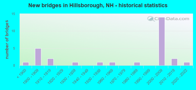
- New bridges - historical statistics
- 1Before 1900
- 51900-1909
- 21910-1919
- 11930-1939
- 11950-1959
- 11960-1969
- 11980-1989
- 142000-2009
- 22010-2019
- 12020-2022

- Reconstructed bridges - Historical Statistics
- 11920-1929
- 11930-1939
- 11940-1949
- 01950-1959
- 01960-1969
- 01970-1979
- 11980-1989
- 41990-1999
- 02000-2009
- 12010-2019


- Bridge Condition - Deck
- 6.7%Excellent
- 26.7%Very good
- 33.3%Good
- 20.0%Satisfactory
- 13.3%Fair

- Bridge Condition - Superstructure
- 6.7%Excellent
- 33.3%Very good
- 33.3%Good
- 6.7%Satisfactory
- 13.3%Fair
- 6.7%Poor

- Bridge Condition - Substructure
- 13.3%Very good
- 60.0%Good
- 20.0%Satisfactory
- 6.7%Fair

- Bridge Condition - Channel
- 18.8%Very good
- 50.0%Good
- 31.3%Satisfactory

- Bridge Condition - Culverts
- 14.3%Excellent
- 14.3%Very good
- 14.3%Good
- 14.3%Satisfactory
- 14.3%Fair
- 28.6%Poor
Find on map >> Show street view
Structure Number: 122008800093, Location: 2.6 MILE FR NH RTE 9 (Lat: 43.144994, Lng: -71.959397), Route carried "on" structure: Other road , Year Built: 1900, Status: Posted for load, Structure Length: 1.04m (3.41ft), Average Daily Traffic: 81 (year 2020), Average Future Daily Traffic: 119 (year 2042), Features Intersected: BEARDS BROOK, Facility Carried by Structure: GLEASON FALLS ROAD
Minimum Vertical Clearance: 30+ m (98+ ft), Kilometerpoint: 2.263, Lanes on structure: 1, Owner: City or Municipal Highway Agency, Approaching Roadway Width: 3.7m (12.1ft), Material/Design: Masonry, Design/Construction: Culvert, Number Of Spans In Main Unit: 1, Length of Maximum Span: 10.4m (34.1ft)
Condition: Channel: Good, Culverts: Poor, Operating Rating: 9.8 metric tons, Method Used To Determine Operating Rating: Field evaluation and documented engineering judgment, Inventory Rating: 5.9 metric tons, Method Used To Determine Inventory Rating: Field evaluation and documented engineering judgment, Structural Evaluation: High priority of replacement, Waterway Adequacy: Better than present minimum criteria, Approach Roadway Alignment: Better than present minimum criteria, Bridge Posting: Required (Relationship of Operating Rating to Maximum Legal Load: > 39.9% below), Length Of Structure Improvement: 1.04m (3.41ft), Designated Inspection Frequency: Every 16 months, Inspection Date: November 2021, Bridge Improvement Cost: $2,718,000, Roadway Improvement Cost: $200,000, Total Project Cost: $3,142,000 ( Estimate for 2022)
Find on map >> Show street view
Structure Number: 122008900064, Location: 0.2 MI FR NH RTE 31 (Lat: 43.124589, Lng: -71.952836), Route carried "on" structure: Other road , Year Built: 1919, Year Reconstructed: 1936, Status: Open, Structure Length: 0.79m (2.59ft), Average Daily Traffic: 81 (year 2020), Average Future Daily Traffic: 119 (year 2042), Features Intersected: SHEDD BROOK, Facility Carried by Structure: SHEDD ROAD
Minimum Vertical Clearance: 30+ m (98+ ft), Kilometerpoint: 0.684, Lanes on structure: 1, Owner: City or Municipal Highway Agency, Approaching Roadway Width: 4.9m (16.1ft), Skew: 1 degrees, Material/Design: Concrete, Design/Construction: Slab, Number Of Spans In Main Unit: 1, Length of Maximum Span: 6.7m (22.0ft), Curb-To-Curb Width: 4.7m (15.4ft), Out-to-Out Width: 5.5m (18.0ft)
Condition: Deck: Fair, Superstructure: Fair, Substructure: Satisfactory, Channel: Satisfactory, Operating Rating: 23.6 metric tons, Method Used To Determine Operating Rating: Load Factor (LF), Inventory Rating: 16.3 metric tons, Method Used To Determine Inventory Rating: Load Factor (LF), Structural Evaluation: Somewhat better than minimum adequacy, Deck Geometry: Better than present minimum criteria, Waterway Adequacy: Equal to present desirable criteria, Approach Roadway Alignment: Equal to present minimum criteria, Length Of Structure Improvement: 0.79m (2.59ft), Designated Inspection Frequency: Every 24 months, Inspection Date: October 2020, Bridge Improvement Cost: $2,718,000, Roadway Improvement Cost: $200,000, Total Project Cost: $3,142,000 ( Estimate for 2022), Deck Structure Type: Concrete Cast-file-Place, Wearing Surface/Protective System: Wearing Surface: Monolithic Concrete
Find on map >> Show street view
Structure Number: 12200920009, Location: 2.7 MI FR NH RTE 9 (Lat: 43.143614, Lng: -71.955725), Route carried "on" structure: Other road , Year Built: 1900, Status: Posted for load, Structure Length: 0.91m (2.99ft), Average Daily Traffic: 81 (year 2020), Truck Traffic: 4%, Average Future Daily Traffic: 119 (year 2042), Features Intersected: BEARDS BROOK, Facility Carried by Structure: BEARD ROAD
Minimum Vertical Clearance: 30+ m (98+ ft), Kilometerpoint: 4.342, Lanes on structure: 2, Owner: City or Municipal Highway Agency, Approaching Roadway Width: 4.3m (14.1ft), Material/Design: Masonry, Design/Construction: Culvert, Number Of Spans In Main Unit: 1, Length of Maximum Span: 9.1m (29.9ft)
Condition: Channel: Very good, Culverts: Fair, Operating Rating: 9.8 metric tons, Method Used To Determine Operating Rating: Field evaluation and documented engineering judgment, Inventory Rating: 6.1 metric tons, Method Used To Determine Inventory Rating: Field evaluation and documented engineering judgment, Structural Evaluation: High priority of replacement, Waterway Adequacy: Better than present minimum criteria, Approach Roadway Alignment: Better than present minimum criteria, Bridge Posting: Required (Relationship of Operating Rating to Maximum Legal Load: > 39.9% below), Length Of Structure Improvement: 0.91m (2.99ft), Designated Inspection Frequency: Every 24 months, Inspection Date: October 2020, Bridge Improvement Cost: $2,718,000, Roadway Improvement Cost: $200,000, Total Project Cost: $3,142,000 ( Estimate for 2022)
Find on map >> Show street view
Structure Number: 122009300044, Location: 1.0 MI FR ANTRIM TL (Lat: 43.111458, Lng: -71.943050), Route carried "on" structure: Other road , Year Built: 1900, Year Reconstructed: 2001, Status: Open, Structure Length: 0.91m (2.99ft), Average Daily Traffic: 733 (year 2020), Truck Traffic: 4%, Average Future Daily Traffic: 1,084 (year 2042), Design Load: HS 15, Features Intersected: BROOK, Facility Carried by Structure: SECOND NH TPK
Minimum Vertical Clearance: 30+ m (98+ ft), Kilometerpoint: 1.609, Lanes on structure: 2, Owner: City or Municipal Highway Agency, Approaching Roadway Width: 6.7m (22.0ft), Material/Design: Masonry, Design/Construction: Culvert, Number Of Spans In Main Unit: 1, Length of Maximum Span: 9.1m (29.9ft), Out-to-Out Width: 6.1m (20.0ft)
Condition: Channel: Good, Culverts: Satisfactory, Operating Rating: 68.1 metric tons, Method Used To Determine Operating Rating: Allowable Stress (AS), Inventory Rating: 68.1 metric tons, Method Used To Determine Inventory Rating: Allowable Stress (AS), Structural Evaluation: Equal to present minimum criteria, Waterway Adequacy: Better than present minimum criteria, Approach Roadway Alignment: Better than present minimum criteria, Length Of Structure Improvement: 0.91m (2.99ft), Designated Inspection Frequency: Every 24 months, Inspection Date: October 2020, Bridge Improvement Cost: $2,718,000, Roadway Improvement Cost: $200,000, Total Project Cost: $3,142,000 ( Estimate for 2022)
Find on map >> Show street view
Structure Number: 122009300045, Location: 1.0 MI. ANTRIM TL (Lat: 43.111642, Lng: -71.943261), Route carried "on" structure: Other road , Year Built: 1900, Year Reconstructed: 2001, Status: Open, Structure Length: 0.85m (2.79ft), Average Daily Traffic: 733 (year 2020), Truck Traffic: 4%, Average Future Daily Traffic: 1,084 (year 2042), Design Load: HS 15, Features Intersected: BROOK, Facility Carried by Structure: SECOND NH TPK
Minimum Vertical Clearance: 30+ m (98+ ft), Kilometerpoint: 1.584, Lanes on structure: 2, Owner: City or Municipal Highway Agency, Approaching Roadway Width: 6.1m (20.0ft), Material/Design: Masonry, Design/Construction: Culvert, Number Of Spans In Main Unit: 1, Length of Maximum Span: 7.0m (23.0ft), Curb-To-Curb Width: 4.5m (14.8ft), Out-to-Out Width: 6.1m (20.0ft)
Condition: Channel: Good, Culverts: Good, Operating Rating: 51.4 metric tons, Method Used To Determine Operating Rating: Allowable Stress (AS), Inventory Rating: 51.4 metric tons, Method Used To Determine Inventory Rating: Allowable Stress (AS), Structural Evaluation: Better than present minimum criteria, Deck Geometry: High priority of replacement, Waterway Adequacy: Better than present minimum criteria, Approach Roadway Alignment: Better than present minimum criteria, Length Of Structure Improvement: 0.85m (2.79ft), Designated Inspection Frequency: Every 24 months, Inspection Date: October 2020, Bridge Improvement Cost: $2,718,000, Roadway Improvement Cost: $200,000, Total Project Cost: $3,142,000 ( Estimate for 2022)
Find on map >> Show street view
Structure Number: 12201000007, Location: 1.3 MI FR NH RTE 31 (Lat: 43.130264, Lng: -71.944719), Route carried "on" structure: Other road , Year Built: 1900, Status: Posted for load, Structure Length: 1.37m (4.49ft), Average Daily Traffic: 81 (year 2020), Truck Traffic: 4%, Average Future Daily Traffic: 119 (year 2042), Features Intersected: BEARDS BROOK, Facility Carried by Structure: JONES ROAD
Minimum Vertical Clearance: 30+ m (98+ ft), Kilometerpoint: 1.711, Lanes on structure: 1, Owner: City or Municipal Highway Agency, Approaching Roadway Width: 3.7m (12.1ft), Material/Design: Masonry, Design/Construction: Culvert, Number Of Spans In Main Unit: 2, Length of Maximum Span: 6.4m (21.0ft)
Condition: Channel: Good, Culverts: Poor, Operating Rating: 9.8 metric tons, Method Used To Determine Operating Rating: Field evaluation and documented engineering judgment, Inventory Rating: 6.1 metric tons, Method Used To Determine Inventory Rating: Field evaluation and documented engineering judgment, Structural Evaluation: High priority of replacement, Waterway Adequacy: Better than present minimum criteria, Approach Roadway Alignment: Equal to present minimum criteria, Bridge Posting: Required (Relationship of Operating Rating to Maximum Legal Load: > 39.9% below), Length Of Structure Improvement: 1.37m (4.49ft), Designated Inspection Frequency: Every 16 months, Inspection Date: November 2021, Bridge Improvement Cost: $2,718,000, Roadway Improvement Cost: $200,000, Total Project Cost: $3,142,000 ( Estimate for 2022)
Find on map >> Show street view
Structure Number: 122010700056, Location: 0.8 MI FR NH RTE 9 (Lat: 43.121625, Lng: -71.933528), Route carried "on" structure: Other road , Year Built: 1965, Year Reconstructed: 2019, Status: Open, Structure Length: 0.73m (2.40ft), Average Daily Traffic: 400 (year 2020), Truck Traffic: 4%, Average Future Daily Traffic: 592 (year 2042), Features Intersected: BEARDS BROOK, Facility Carried by Structure: BEARD ROAD
Minimum Vertical Clearance: 30+ m (98+ ft), Kilometerpoint: 1.207, Lanes on structure: 2, Owner: City or Municipal Highway Agency, Approaching Roadway Width: 6.1m (20.0ft), Material/Design: Concrete, Design/Construction: Slab, Number Of Spans In Main Unit: 1, Length of Maximum Span: 5.2m (17.1ft), Curb or Sidewalk Widths: Left: 0.1m (0.3ft), Right: 0.1m (0.3ft), Curb-To-Curb Width: 6.4m (21.0ft), Out-to-Out Width: 7.2m (23.6ft)
Condition: Deck: Excellent, Superstructure: Excellent, Substructure: Good, Channel: Satisfactory, Operating Rating: 50.8 metric tons, Method Used To Determine Operating Rating: Load and Resistance Factor (LRFR), Inventory Rating: 39.2 metric tons, Method Used To Determine Inventory Rating: Load and Resistance Factor (LRFR), Structural Evaluation: Better than present minimum criteria, Deck Geometry: Meets minimum limits, Waterway Adequacy: Equal to present desirable criteria, Approach Roadway Alignment: Equal to present desirable criteria, Length Of Structure Improvement: 0.73m (2.40ft), Designated Inspection Frequency: Every 24 months, Inspection Date: October 2020, Bridge Improvement Cost: $2,718,000, Roadway Improvement Cost: $200,000, Total Project Cost: $3,142,000 ( Estimate for 2022), Deck Structure Type: Concrete Precast Panels, Wearing Surface/Protective System: Wearing Surface: Bituminous
Find on map >> Show street view
Structure Number: 122011000051, Location: NH 9 at Beards Brook (Lat: 43.117250, Lng: -71.929344), Route carried "on" structure: State highway 9, Year Built: 2002, Status: Open, Structure Length: 12.53m (41.11ft), Average Daily Traffic: 5,579 (year 2020), Truck Traffic: 7%, Average Future Daily Traffic: 8,256 (year 2042), Design Load: HS 25 or greater, Features Intersected: BEARDS BROOK,BEARDS RD
Minimum Vertical Clearance: 30+ m (98+ ft), Kilometerpoint: 68.074, Lanes on structure: 2, Lanes under structure: 2, Base Highway Network: Yes, Owner: State Highway Agency, Approaching Roadway Width: 13.1m (43.0ft), Material/Design: Steel continuous, Design/Construction: Stringer/Multi-beam, Number Of Spans In Main Unit: 3, Length of Maximum Span: 57.0m (187.0ft), Curb or Sidewalk Widths: Left: 0.1m (0.3ft), Right: 0.1m (0.3ft), Curb-To-Curb Width: 13.1m (43.0ft), Out-to-Out Width: 14.3m (46.9ft)
Condition: Deck: Very good, Superstructure: Very good, Substructure: Very good, Channel: Good, Operating Rating: 69.9 metric tons, Method Used To Determine Operating Rating: Load Factor (LF), Inventory Rating: 41.7 metric tons, Method Used To Determine Inventory Rating: Load Factor (LF), Structural Evaluation: Equal to present desirable criteria, Deck Geometry: Somewhat better than minimum adequacy, Underclear: Superior to present desirable criteria, Waterway Adequacy: Equal to present desirable criteria, Approach Roadway Alignment: Superior to present desirable criteria, Length Of Structure Improvement: 12.53m (41.11ft), Designated Inspection Frequency: Every 24 months, Inspection Date: March 2020, Bridge Improvement Cost: $2,718,000, Roadway Improvement Cost: $200,000, Total Project Cost: $3,142,000 ( Estimate for 2022), Deck Structure Type: Concrete Cast-file-Place, Wearing Surface/Protective System: Wearing Surface: Bituminous, Membrane: Other, Deck Protection: Epoxy Coated Reinforcing
Find on map >> Show street view
Structure Number: 122011100042, Location: 0.3MI JCT 9-31-202 (Lat: 43.113117, Lng: -71.925247), Route carried "on" structure: State highway 9, Year Built: 1951, Year Reconstructed: 2004, Status: Open, Structure Length: 2.38m (7.81ft), Average Daily Traffic: 2,731 (year 2020), Truck Traffic: 7%, Average Future Daily Traffic: 4,041 (year 2042), Design Load: H 20, Features Intersected: BEARDS BROOK
Minimum Vertical Clearance: 30+ m (98+ ft), Kilometerpoint: 4.756, Lanes on structure: 2, Owner: City or Municipal Highway Agency, Approaching Roadway Width: 9.1m (29.9ft), Skew: 4 degrees, Material/Design: Steel, Design/Construction: Stringer/Multi-beam, Number Of Spans In Main Unit: 1, Length of Maximum Span: 20.7m (67.9ft), Curb or Sidewalk Widths: Left: 0.1m (0.3ft), Right: 0.1m (0.3ft), Curb-To-Curb Width: 9.1m (29.9ft), Out-to-Out Width: 10.4m (34.1ft)
Condition: Deck: Satisfactory, Superstructure: Good, Substructure: Satisfactory, Channel: Satisfactory, Operating Rating: 44.3 metric tons, Method Used To Determine Operating Rating: Load Factor (LF), Inventory Rating: 26.5 metric tons, Method Used To Determine Inventory Rating: Load Factor (LF), Structural Evaluation: Equal to present minimum criteria, Deck Geometry: Meets minimum limits, Waterway Adequacy: Equal to present desirable criteria, Approach Roadway Alignment: Equal to present desirable criteria, Length Of Structure Improvement: 2.38m (7.81ft), Designated Inspection Frequency: Every 24 months, Inspection Date: October 2020, Bridge Improvement Cost: $2,718,000, Roadway Improvement Cost: $200,000, Total Project Cost: $3,142,000 ( Estimate for 2022), Deck Structure Type: Concrete Cast-file-Place, Wearing Surface/Protective System: Wearing Surface: Integral Concrete
Find on map >> Show street view
Structure Number: 122011200042, Location: 1.4 MI. RTE. 9 (Lat: 43.112914, Lng: -71.925056), Route carried "on" structure: Other road , Year Built: 1919, Year Reconstructed: 1931, Status: Open, Structure Length: 1.10m (3.61ft), Average Daily Traffic: 648 (year 2020), Truck Traffic: 4%, Average Future Daily Traffic: 959 (year 2042), Features Intersected: BEARDS BROOK, Facility Carried by Structure: SAW MILL ROAD
Minimum Vertical Clearance: 30+ m (98+ ft), Kilometerpoint: 0.042, Lanes on structure: 2, Owner: City or Municipal Highway Agency, Approaching Roadway Width: 6.7m (22.0ft), Material/Design: Concrete, Design/Construction: Frame, Number Of Spans In Main Unit: 1, Length of Maximum Span: 9.8m (32.2ft), Curb-To-Curb Width: 7.9m (25.9ft), Out-to-Out Width: 8.8m (28.9ft)
Condition: Deck: Satisfactory, Superstructure: Satisfactory, Substructure: Satisfactory, Channel: Good, Operating Rating: 36.3 metric tons, Method Used To Determine Operating Rating: Field evaluation and documented engineering judgment, Inventory Rating: 26.3 metric tons, Method Used To Determine Inventory Rating: Field evaluation and documented engineering judgment, Structural Evaluation: Equal to present minimum criteria, Deck Geometry: Somewhat better than minimum adequacy, Waterway Adequacy: Superior to present desirable criteria, Approach Roadway Alignment: Better than present minimum criteria, Length Of Structure Improvement: 1.10m (3.61ft), Designated Inspection Frequency: Every 24 months, Inspection Date: October 2020, Bridge Improvement Cost: $2,718,000, Roadway Improvement Cost: $200,000, Total Project Cost: $3,142,000 ( Estimate for 2022), Deck Structure Type: Concrete Cast-file-Place, Wearing Surface/Protective System: Wearing Surface: Bituminous
Find on map >> Show street view
Structure Number: 122011200051, Location: JCT NH 9/US202 (Lat: 43.116367, Lng: -71.917831), Route carried "on" structure: State highway 9, Year Built: 2001, Status: Open, Structure Length: 2.65m (8.69ft), Average Daily Traffic: 9,025 (year 2020), Truck Traffic: 7%, Average Future Daily Traffic: 13,357 (year 2042), Design Load: HS 25 or greater, Features Intersected: US202
Minimum Vertical Clearance: 30+ m (98+ ft), Kilometerpoint: 69.013, Lanes on structure: 2, Lanes under structure: 2, Base Highway Network: Yes, Owner: State Highway Agency, Approaching Roadway Width: 19.5m (64.0ft), Skew: 1 degrees, Material/Design: Concrete, Design/Construction: Stringer/Multi-beam, Number Of Spans In Main Unit: 1, Length of Maximum Span: 23.4m (76.8ft), Curb or Sidewalk Widths: Left: 0.1m (0.3ft), Right: 0.1m (0.3ft), Curb-To-Curb Width: 20.6m (67.6ft), Out-to-Out Width: 21.6m (70.9ft)
Condition: Deck: Very good, Superstructure: Good, Substructure: Good, Operating Rating: 69.9 metric tons, Method Used To Determine Operating Rating: Load Factor (LF), Inventory Rating: 41.7 metric tons, Method Used To Determine Inventory Rating: Load Factor (LF), Structural Evaluation: Better than present minimum criteria, Deck Geometry: Superior to present desirable criteria, Underclear: Equal to present minimum criteria, Approach Roadway Alignment: Superior to present desirable criteria, Length Of Structure Improvement: 2.65m (8.69ft), Designated Inspection Frequency: Every 24 months, Inspection Date: March 2020, Bridge Improvement Cost: $2,718,000, Roadway Improvement Cost: $200,000, Total Project Cost: $3,142,000 ( Estimate for 2022), Deck Structure Type: Concrete Cast-file-Place, Wearing Surface/Protective System: Wearing Surface: Bituminous, Membrane: Preformed Fabric, Deck Protection: Epoxy Coated Reinforcing
Find on map >> Show street view
Structure Number: 12201160005, Location: NH 9 under Bible Hill Ro (Lat: 43.116264, Lng: -71.921108), Route carried "on" structure: Other road , Year Built: 2000, Status: Open, Structure Length: 9.48m (31.10ft), Average Daily Traffic: 81 (year 2020), Truck Traffic: 4%, Average Future Daily Traffic: 119 (year 2042), Design Load: HS 25 or greater, Features Intersected: NH 9,RAMP A, Facility Carried by Structure: BIBLE HILL ROAD
Minimum Vertical Clearance: 30+ m (98+ ft), Kilometerpoint: 0.608, Lanes on structure: 2, Lanes under structure: 4, Owner: State Highway Agency, Approaching Roadway Width: 9.1m (29.9ft), Skew: 4 degrees, Material/Design: Steel continuous, Design/Construction: Stringer/Multi-beam, Number Of Spans In Main Unit: 2, Length of Maximum Span: 48.8m (160.1ft), Curb or Sidewalk Widths: Left: 0.2m (0.7ft), Right: 1.5m (4.9ft), Curb-To-Curb Width: 8.5m (27.9ft), Out-to-Out Width: 11.4m (37.4ft)
Condition: Deck: Good, Superstructure: Very good, Substructure: Good, Operating Rating: 73.5 metric tons, Method Used To Determine Operating Rating: Load Factor (LF), Inventory Rating: 43.5 metric tons, Method Used To Determine Inventory Rating: Load Factor (LF), Structural Evaluation: Better than present minimum criteria, Deck Geometry: Better than present minimum criteria, Underclear: Equal to present minimum criteria, Approach Roadway Alignment: Equal to present desirable criteria, Length Of Structure Improvement: 9.48m (31.10ft), Designated Inspection Frequency: Every 24 months, Inspection Date: March 2020, Bridge Improvement Cost: $2,718,000, Roadway Improvement Cost: $200,000, Total Project Cost: $3,142,000 ( Estimate for 2022), Deck Structure Type: Concrete Cast-file-Place, Wearing Surface/Protective System: Wearing Surface: Bituminous, Membrane: Preformed Fabric, Deck Protection: Epoxy Coated Reinforcing
Find on map >> Show street view
Structure Number: 122011700035, Location: 0.5 MI FROM ANTRIM TL (Lat: 43.111514, Lng: -71.919231), Route carried "on" structure: US 202, Year Built: 1988, Year Reconstructed: 2001, Status: Open, Structure Length: 3.41m (11.19ft), Average Daily Traffic: 5,748 (year 2020), Truck Traffic: 7%, Average Future Daily Traffic: 8,507 (year 2042), Design Load: HS 20, Features Intersected: N BRANCH RIVER
Minimum Vertical Clearance: 30+ m (98+ ft), Kilometerpoint: 52.572, Lanes on structure: 4, Owner: State Highway Agency, Approaching Roadway Width: 20.8m (68.2ft), Material/Design: Concrete, Design/Construction: Frame, Number Of Spans In Main Unit: 2, Length of Maximum Span: 15.2m (49.9ft), Curb or Sidewalk Widths: Left: 1.5m (4.9ft), Right: 1.5m (4.9ft), Curb-To-Curb Width: 18.3m (60.0ft), Out-to-Out Width: 18.4m (60.4ft)
Condition: Deck: Good, Superstructure: Good, Substructure: Good, Channel: Very good, Operating Rating: 54.4 metric tons, Method Used To Determine Operating Rating: Load Factor (LF), Inventory Rating: 32.7 metric tons, Method Used To Determine Inventory Rating: Load Factor (LF), Structural Evaluation: Better than present minimum criteria, Deck Geometry: Somewhat better than minimum adequacy, Waterway Adequacy: Equal to present desirable criteria, Approach Roadway Alignment: Equal to present desirable criteria, Length Of Structure Improvement: 3.41m (11.19ft), Designated Inspection Frequency: Every 24 months, Inspection Date: March 2020, Bridge Improvement Cost: $2,718,000, Roadway Improvement Cost: $200,000, Total Project Cost: $3,142,000 ( Estimate for 2022), Deck Structure Type: Concrete Cast-file-Place, Wearing Surface/Protective System: Wearing Surface: Bituminous, Membrane: Preformed Fabric, Deck Protection: Epoxy Coated Reinforcing
Find on map >> Show street view
Structure Number: 122011800045, Location: Bible Hill Road / US202 (Lat: 43.113872, Lng: -71.918561), Route carried "on" structure: Other road , Year Built: 2000, Status: Open, Structure Length: 3.32m (10.89ft), Average Daily Traffic: 81 (year 2020), Truck Traffic: 4%, Average Future Daily Traffic: 119 (year 2042), Design Load: HS 25 or greater, Features Intersected: US202, Facility Carried by Structure: BIBLE HILL ROAD
Minimum Vertical Clearance: 30+ m (98+ ft), Kilometerpoint: 0.262, Lanes on structure: 2, Lanes under structure: 2, Owner: State Highway Agency, Approaching Roadway Width: 9.0m (29.5ft), Skew: 4 degrees, Material/Design: Steel, Design/Construction: Stringer/Multi-beam, Number Of Spans In Main Unit: 1, Length of Maximum Span: 29.9m (98.1ft), Curb or Sidewalk Widths: Left: 0.2m (0.7ft), Right: 1.5m (4.9ft), Curb-To-Curb Width: 9.0m (29.5ft), Out-to-Out Width: 11.4m (37.4ft)
Condition: Deck: Good, Superstructure: Very good, Substructure: Good, Operating Rating: 73.5 metric tons, Method Used To Determine Operating Rating: Load Factor (LF), Inventory Rating: 43.9 metric tons, Method Used To Determine Inventory Rating: Load Factor (LF), Structural Evaluation: Better than present minimum criteria, Deck Geometry: Better than present minimum criteria, Underclear: Somewhat better than minimum adequacy, Approach Roadway Alignment: Better than present minimum criteria, Length Of Structure Improvement: 3.32m (10.89ft), Designated Inspection Frequency: Every 24 months, Inspection Date: March 2020, Bridge Improvement Cost: $2,718,000, Roadway Improvement Cost: $200,000, Total Project Cost: $3,142,000 ( Estimate for 2022), Deck Structure Type: Concrete Cast-file-Place, Wearing Surface/Protective System: Wearing Surface: Bituminous, Membrane: Built-up, Deck Protection: Epoxy Coated Reinforcing
Find on map >> Show street view
Structure Number: 122013700051, Location: 2.2MI W HENNIKER T/L (Lat: 43.121389, Lng: -71.901292), Route carried "on" structure: Other road , Year Built: 2002, Status: Open, Structure Length: 3.57m (11.71ft), Average Daily Traffic: 3,015 (year 2020), Truck Traffic: 6%, Average Future Daily Traffic: 4,462 (year 2042), Design Load: HS 25 or greater, Features Intersected: US202,NH 9, Facility Carried by Structure: CENTER ROAD
Minimum Vertical Clearance: 30+ m (98+ ft), Kilometerpoint: 0.935, Lanes on structure: 2, Lanes under structure: 3, Owner: State Highway Agency, Approaching Roadway Width: 9.1m (29.9ft), Material/Design: Steel, Design/Construction: Stringer/Multi-beam, Number Of Spans In Main Unit: 1, Length of Maximum Span: 31.7m (104.0ft), Curb or Sidewalk Widths: Left: 1.5m (4.9ft), Right: 1.5m (4.9ft), Curb-To-Curb Width: 9.1m (29.9ft), Out-to-Out Width: 12.8m (42.0ft)
Condition: Deck: Good, Superstructure: Good, Substructure: Good, Operating Rating: 72.3 metric tons, Method Used To Determine Operating Rating: Load Factor (LF), Inventory Rating: 43.3 metric tons, Method Used To Determine Inventory Rating: Load Factor (LF), Structural Evaluation: Better than present minimum criteria, Deck Geometry: Meets minimum limits, Underclear: Somewhat better than minimum adequacy, Approach Roadway Alignment: Somewhat better than minimum adequacy, Length Of Structure Improvement: 3.57m (11.71ft), Designated Inspection Frequency: Every 24 months, Inspection Date: March 2020, Bridge Improvement Cost: $2,718,000, Roadway Improvement Cost: $200,000, Total Project Cost: $3,142,000 ( Estimate for 2022), Deck Structure Type: Concrete Cast-file-Place, Wearing Surface/Protective System: Wearing Surface: Bituminous, Membrane: Built-up, Deck Protection: Epoxy Coated Reinforcing
Find on map >> Show street view
Structure Number: 122014400033, Location: .1 MI. FROM JCT. US 202 (Lat: 43.113369, Lng: -71.894119), Route carried "on" structure: State highway 149, Year Built: 1893, Year Reconstructed: 1940, Status: Open, Structure Length: 7.50m (24.61ft), Average Daily Traffic: 4,243 (year 2020), Truck Traffic: 10%, Average Future Daily Traffic: 6,279 (year 2042), Design Load: H 15, Features Intersected: CONTOOCOOK RIVER
Minimum Vertical Clearance: 30+ m (98+ ft), Kilometerpoint: 2.382, Lanes on structure: 2, Owner: State Highway Agency, Approaching Roadway Width: 6.4m (21.0ft), Material/Design: Concrete, Design/Construction: Frame, Number Of Spans In Main Unit: 1, Number Of Approach Spans: 1, Length of Maximum Span: 21.3m (69.9ft), Curb or Sidewalk Widths: Left: 1.4m (4.6ft), Right: 0.0m, Curb-To-Curb Width: 6.5m (21.3ft), Out-to-Out Width: 8.7m (28.5ft)
Condition: Deck: Fair, Superstructure: Fair, Substructure: Fair, Channel: Good, Operating Rating: 33.0 metric tons, Method Used To Determine Operating Rating: Load Factor (LF), Inventory Rating: 19.8 metric tons, Method Used To Determine Inventory Rating: Load Factor (LF), Structural Evaluation: Somewhat better than minimum adequacy, Deck Geometry: High priority of replacement, Waterway Adequacy: Equal to present desirable criteria, Approach Roadway Alignment: Equal to present minimum criteria, Length Of Structure Improvement: 7.50m (24.61ft), Designated Inspection Frequency: Every 24 months, Underwater Inspection Frequency: Every 60 months, Inspection Date: August 2021, Underwater Inspection Date: August 2021, Bridge Improvement Cost: $2,718,000, Roadway Improvement Cost: $200,000, Total Project Cost: $3,142,000 ( Estimate for 2022), Deck Structure Type: Concrete Cast-file-Place, Wearing Surface/Protective System: Wearing Surface: Bituminous
Find on map >> Show street view
Structure Number: 122015200095, Location: 0.58 MI N GOULD POND JCT (Lat: 43.156489, Lng: -71.901044), Route carried "on" structure: Other road , Year Built: 2015, Status: Open, Structure Length: 0.76m (2.49ft), Average Daily Traffic: 81 (year 2020), Average Future Daily Traffic: 119 (year 2042), Design Load: HL 93, Features Intersected: SAND BROOK, Facility Carried by Structure: BOG ROAD
Minimum Vertical Clearance: 30+ m (98+ ft), Kilometerpoint: 3.146, Lanes on structure: 2, Owner: City or Municipal Highway Agency, Approaching Roadway Width: 10.1m (33.1ft), Skew: 1 degrees, Material/Design: Concrete, Design/Construction: Frame, Number Of Spans In Main Unit: 1, Length of Maximum Span: 7.0m (23.0ft), Curb or Sidewalk Widths: Left: 0.2m (0.7ft), Right: 0.2m (0.7ft), Curb-To-Curb Width: 10.1m (33.1ft), Out-to-Out Width: 11.3m (37.1ft)
Condition: Deck: Very good, Superstructure: Very good, Substructure: Very good, Channel: Satisfactory, Operating Rating: 50.4 metric tons, Method Used To Determine Operating Rating: Load and Resistance Factor (LRFR), Inventory Rating: 38.9 metric tons, Method Used To Determine Inventory Rating: Load and Resistance Factor (LRFR), Structural Evaluation: Equal to present desirable criteria, Deck Geometry: Superior to present desirable criteria, Waterway Adequacy: Better than present minimum criteria, Approach Roadway Alignment: Equal to present minimum criteria, Length Of Structure Improvement: 0.76m (2.49ft), Designated Inspection Frequency: Every 24 months, Inspection Date: October 2020, Bridge Improvement Cost: $2,718,000, Roadway Improvement Cost: $200,000, Total Project Cost: $3,142,000 ( Estimate for 2022), Deck Structure Type: Concrete Precast Panels, Wearing Surface/Protective System: Wearing Surface: Gravel, Membrane: Preformed Fabric, Deck Protection: Epoxy Coated Reinforcing
Find on map >> Show street view
Structure Number: 122015700056, Location: 1.2MI W HENNIKER T/L (Lat: 43.130367, Lng: -71.885103), Route carried "on" structure: Other road , Year Built: 2002, Status: Open, Structure Length: 4.91m (16.11ft), Average Daily Traffic: 81 (year 2020), Truck Traffic: 4%, Average Future Daily Traffic: 119 (year 2042), Design Load: HS 25 or greater, Features Intersected: US202,NH 9, Facility Carried by Structure: OLD HENNIKER ROAD
Minimum Vertical Clearance: 30+ m (98+ ft), Kilometerpoint: 0.726, Lanes on structure: 2, Lanes under structure: 3, Owner: State Highway Agency, Approaching Roadway Width: 10.4m (34.1ft), Skew: 4 degrees, Material/Design: Steel, Design/Construction: Stringer/Multi-beam, Number Of Spans In Main Unit: 1, Length of Maximum Span: 43.3m (142.1ft), Curb or Sidewalk Widths: Left: 0.2m (0.7ft), Right: 1.5m (4.9ft), Curb-To-Curb Width: 9.8m (32.2ft), Out-to-Out Width: 11.9m (39.0ft)
Condition: Deck: Very good, Superstructure: Very good, Substructure: Good, Operating Rating: 71.8 metric tons, Method Used To Determine Operating Rating: Load Factor (LF), Inventory Rating: 43.3 metric tons, Method Used To Determine Inventory Rating: Load Factor (LF), Structural Evaluation: Better than present minimum criteria, Deck Geometry: Equal to present desirable criteria, Underclear: Equal to present minimum criteria, Approach Roadway Alignment: Better than present minimum criteria, Length Of Structure Improvement: 4.91m (16.11ft), Designated Inspection Frequency: Every 24 months, Inspection Date: March 2020, Bridge Improvement Cost: $2,718,000, Roadway Improvement Cost: $200,000, Total Project Cost: $3,142,000 ( Estimate for 2022), Deck Structure Type: Concrete Cast-file-Place, Wearing Surface/Protective System: Wearing Surface: Bituminous, Membrane: Preformed Fabric, Deck Protection: Epoxy Coated Reinforcing
Find on map >> Show street view
Structure Number: 12201580008, Location: TOWN ROAD (Lat: 43.148472, Lng: -71.893983), Route carried "on" structure: Other road , Year Built: 2021, Status: Open, Structure Length: 0.82m (2.69ft), Average Daily Traffic: 100 (year 1993), Truck Traffic: 5%, Average Future Daily Traffic: 148 (year 2042), Design Load: HL 93, Features Intersected: NELSON BROOK, Facility Carried by Structure: RED FOX CROSSING
Minimum Vertical Clearance: 30+ m (98+ ft), Kilometerpoint: 0.105, Lanes on structure: 2, Owner: Local Agency, Approaching Roadway Width: 5.8m (19.0ft), Material/Design: Concrete, Design/Construction: Culvert, Number Of Spans In Main Unit: 1, Length of Maximum Span: 7.6m (24.9ft)
Condition: Channel: Satisfactory, Culverts: Excellent, Operating Rating: 50.2 metric tons, Method Used To Determine Operating Rating: Load and Resistance Factor (LRFR), Inventory Rating: 38.7 metric tons, Method Used To Determine Inventory Rating: Load and Resistance Factor (LRFR), Structural Evaluation: Superior to present desirable criteria, Waterway Adequacy: Equal to present desirable criteria, Approach Roadway Alignment: Equal to present desirable criteria, Length Of Structure Improvement: 0.82m (2.69ft), Designated Inspection Frequency: Every 24 months, Inspection Date: November 2021, Bridge Improvement Cost: $2,718,000, Roadway Improvement Cost: $200,000, Total Project Cost: $3,142,000 ( Estimate for 2022), Wearing Surface/Protective System: Wearing Surface: Gravel
Find on map >> Show street view
Structure Number: 12201650006, Location: 0.8MI W HENNIKER T/L (Lat: 43.135917, Lng: -71.881083), Route carried "on" structure: US 202, Year Built: 2002, Status: Open, Structure Length: 3.07m (10.07ft), Average Daily Traffic: 9,025 (year 2020), Truck Traffic: 7%, Average Future Daily Traffic: 13,357 (year 2042), Design Load: HS 25 or greater, Features Intersected: EASTERN CONNECTOR
Minimum Vertical Clearance: 30+ m (98+ ft), Kilometerpoint: 56.922, Lanes on structure: 2, Lanes under structure: 4, Base Highway Network: Yes, Owner: State Highway Agency, Approaching Roadway Width: 13.2m (43.3ft), Skew: 5 degrees, Material/Design: Prestressed concrete, Design/Construction: Stringer/Multi-beam, Number Of Spans In Main Unit: 1, Length of Maximum Span: 27.8m (91.2ft), Curb or Sidewalk Widths: Left: 0.1m (0.3ft), Right: 0.1m (0.3ft), Curb-To-Curb Width: 13.7m (44.9ft), Out-to-Out Width: 14.9m (48.9ft)
Condition: Deck: Good, Superstructure: Good, Substructure: Good, Operating Rating: 79.8 metric tons, Method Used To Determine Operating Rating: Load Factor (LF), Inventory Rating: 40.8 metric tons, Method Used To Determine Inventory Rating: Load Factor (LF), Structural Evaluation: Better than present minimum criteria, Deck Geometry: Superior to present desirable criteria, Underclear: Meets minimum limits, Approach Roadway Alignment: Equal to present desirable criteria, Length Of Structure Improvement: 3.07m (10.07ft), Designated Inspection Frequency: Every 24 months, Inspection Date: March 2020, Bridge Improvement Cost: $2,718,000, Roadway Improvement Cost: $200,000, Total Project Cost: $3,142,000 ( Estimate for 2022), Deck Structure Type: Concrete Cast-file-Place, Wearing Surface/Protective System: Wearing Surface: Bituminous, Membrane: Other, Deck Protection: Epoxy Coated Reinforcing
Find on map >> Show street view
Structure Number: 122016900081, Location: 0.4 MI FR. HENNIKER T/L (Lat: 43.150006, Lng: -71.880869), Route carried "on" structure: Other road , Year Built: 2013, Status: Open, Structure Length: 0.79m (2.59ft), Average Daily Traffic: 300 (year 2007), Truck Traffic: 4%, Average Future Daily Traffic: 444 (year 2042), Design Load: HL 93, Features Intersected: SAND BROOK, Facility Carried by Structure: HUMMINGBIRD LANE
Minimum Vertical Clearance: 30+ m (98+ ft), Kilometerpoint: 0.652, Lanes on structure: 2, Owner: Local Agency, Approaching Roadway Width: 6.1m (20.0ft), Skew: 2 degrees, Material/Design: Concrete, Design/Construction: Culvert, Number Of Spans In Main Unit: 1, Length of Maximum Span: 7.3m (24.0ft)
Condition: Channel: Very good, Culverts: Very good, Operating Rating: 89.8 metric tons, Method Used To Determine Operating Rating: Load Factor (LF), Inventory Rating: 54.8 metric tons, Method Used To Determine Inventory Rating: Load Factor (LF), Structural Evaluation: Equal to present desirable criteria, Waterway Adequacy: Superior to present desirable criteria, Approach Roadway Alignment: Equal to present minimum criteria, Length Of Structure Improvement: 0.79m (2.59ft), Designated Inspection Frequency: Every 24 months, Inspection Date: October 2020, Bridge Improvement Cost: $2,718,000, Roadway Improvement Cost: $200,000, Total Project Cost: $3,142,000 ( Estimate for 2022)
Find on map >> Show street view
Structure Number: 122017100064, Location: 0.3 MI. HENNIKER TL (Lat: 43.136383, Lng: -71.874456), Route carried "on" structure: Other road , Year Built: 1933, Year Reconstructed: 1991, Status: Open, Structure Length: 6.83m (22.41ft), Average Daily Traffic: 403 (year 2020), Truck Traffic: 4%, Average Future Daily Traffic: 596 (year 2042), Design Load: H 15, Features Intersected: CONTOOCOOK RIVER, Facility Carried by Structure: CONTOOCOOK FALLS R
Minimum Vertical Clearance: 30+ m (98+ ft), Kilometerpoint: 0.521, Lanes on structure: 2, Owner: City or Municipal Highway Agency, Approaching Roadway Width: 7.0m (23.0ft), Skew: 3 degrees, Material/Design: Steel, Design/Construction: Girder and Floorbeam System, Number Of Spans In Main Unit: 2, Length of Maximum Span: 31.7m (104.0ft), Curb-To-Curb Width: 7.3m (24.0ft), Out-to-Out Width: 8.8m (28.9ft)
Condition: Deck: Satisfactory, Superstructure: Poor, Substructure: Good, Channel: Good, Operating Rating: 22.7 metric tons, Method Used To Determine Operating Rating: Load Factor (LF), Inventory Rating: 15.4 metric tons, Method Used To Determine Inventory Rating: Load Factor (LF), Structural Evaluation: Meets minimum limits, Deck Geometry: Meets minimum limits, Waterway Adequacy: Better than present minimum criteria, Approach Roadway Alignment: Equal to present desirable criteria, Length Of Structure Improvement: 6.83m (22.41ft), Designated Inspection Frequency: Every 16 months, Critical Feature Inspection Frequency: Every 24 months, Underwater Inspection Frequency: Every 60 months, Inspection Date: October 2021, Critical Feature Inspection Date: August 2020, Underwater Inspection Date: September 2017, Bridge Improvement Cost: $2,718,000, Roadway Improvement Cost: $200,000, Total Project Cost: $3,142,000 ( Estimate for 2022), Deck Structure Type: Concrete Cast-file-Place, Wearing Surface/Protective System: Wearing Surface: Bituminous, Membrane: Preformed Fabric, Deck Protection: Epoxy Coated Reinforcing
Find on map >> Show street view
Structure Number: 122011000051, Location: NH 9 at Beards Brook (Lat: 43.117250, Lng: -71.929344), Route carried "under" structure: Other road , Year Built: 2002, Structure Length: 0. m, Average Daily Traffic: 460 (year 2015), Truck Traffic: 4%, Features Intersected: BEARDS BROOK,BEARDS RD, Facility Carried by Structure: NH 9
Minimum Vertical Clearance: 30+ m (98+ ft), Kilometerpoint: 0.000, Lanes on structure: 2, Lanes under structure: 2, Material/Design: Steel continuous, Design/Construction: Stringer/Multi-beam, Length of Maximum Span: 57.0m (187.0ft)
Find on map >> Show street view
Structure Number: 122011200051, Location: JCT NH 9/US202 (Lat: 43.116367, Lng: -71.917831), Route carried "under" structure: Ramp US 202, Year Built: 2001, Structure Length: 0. m, Average Daily Traffic: 6,300 (year 2014), Truck Traffic: 7%, Features Intersected: US202, Facility Carried by Structure: NH 9
Minimum Vertical Clearance: 5.12m (16.80ft), Kilometerpoint: 1.000, Lanes on structure: 2, Lanes under structure: 2, Material/Design: Concrete, Design/Construction: Stringer/Multi-beam, Length of Maximum Span: 23.4m (76.8ft)
Find on map >> Show street view
Structure Number: 12201160005, Location: NH 9 under Bible Hill Ro (Lat: 43.116264, Lng: -71.921108), Route carried "under" structure: State highway 9, Year Built: 2000, Structure Length: 0. m, Average Daily Traffic: 6,300 (year 2014), Truck Traffic: 7%, Features Intersected: NH 9,RAMP A, Facility Carried by Structure: BIBLE HILL ROAD
Minimum Vertical Clearance: 5.08m (16.67ft), Kilometerpoint: 0.000, Lanes on structure: 2, Lanes under structure: 4, Material/Design: Steel continuous, Design/Construction: Stringer/Multi-beam, Length of Maximum Span: 48.8m (160.1ft)
Find on map >> Show street view
Structure Number: 122011800045, Location: Bible Hill Road / US202 (Lat: 43.113872, Lng: -71.918561), Route carried "under" structure: US 202, Year Built: 2000, Structure Length: 0. m, Average Daily Traffic: 6,300 (year 2014), Truck Traffic: 7%, Features Intersected: US202, Facility Carried by Structure: BIBLE HILL ROAD
Minimum Vertical Clearance: 14.48m (47.51ft), Kilometerpoint: 2.000, Lanes on structure: 2, Lanes under structure: 2, Material/Design: Steel, Design/Construction: Stringer/Multi-beam, Length of Maximum Span: 29.9m (98.1ft)
Find on map >> Show street view
Structure Number: 122013700051, Location: 2.2MI W HENNIKER T/L (Lat: 43.121389, Lng: -71.901292), Route carried "under" structure: US 202, Year Built: 2002, Structure Length: 0. m, Average Daily Traffic: 8,400 (year 2014), Truck Traffic: 7%, Features Intersected: US202,NH 9, Facility Carried by Structure: CENTER ROAD
Minimum Vertical Clearance: 4.48m (14.70ft), Kilometerpoint: 3.000, Lanes on structure: 2, Lanes under structure: 3, Material/Design: Steel, Design/Construction: Stringer/Multi-beam, Length of Maximum Span: 31.7m (104.0ft)
Find on map >> Show street view
Structure Number: 122015700056, Location: 1.2MI W HENNIKER T/L (Lat: 43.130367, Lng: -71.885103), Route carried "under" structure: US 202, Year Built: 2002, Structure Length: 0. m, Average Daily Traffic: 13,000 (year 2015), Truck Traffic: 7%, Features Intersected: US202,NH 9, Facility Carried by Structure: OLD HENNIKER ROAD
Minimum Vertical Clearance: 5.03m (16.50ft), Kilometerpoint: 5.000, Lanes on structure: 2, Lanes under structure: 3, Material/Design: Steel, Design/Construction: Stringer/Multi-beam, Length of Maximum Span: 43.3m (142.1ft)
Find on map >> Show street view
Structure Number: 12201650006, Location: 0.8MI W HENNIKER T/L (Lat: 43.135917, Lng: -71.881083), Route carried "under" structure: Ramp State highway , Year Built: 2002, Structure Length: 0. m, Average Daily Traffic: 8,600 (year 2001), Truck Traffic: 7%, Features Intersected: EASTERN CONNECTOR, Facility Carried by Structure: US202,NH 9
Minimum Vertical Clearance: 5.18m (16.99ft), Kilometerpoint: 6.000, Lanes on structure: 2, Lanes under structure: 4, Material/Design: Prestressed concrete, Design/Construction: Stringer/Multi-beam, Length of Maximum Span: 27.8m (91.2ft)