Bridge Statistics for Hillsdale, Kansas (KS)
Condition, Traffic, Stress, Structural Evaluation, Project Costs
- National Bridge Inventory (NBI) Statistics
- 25Number of bridges
- 413ft / 126mTotal length
- $2,092,000Total costs
- 55,517Total average daily traffic
- 6,421Total average daily truck traffic
- 110,322Total future (year 2040) average daily traffic
- National Bridge Inventory (NBI) Registered Bridges for Hillsdale
- No street view available for this location
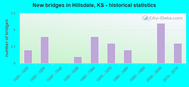
- New bridges - historical statistics
- 21920-1929
- 41930-1939
- 11950-1959
- 41960-1969
- 31970-1979
- 21980-1989
- 62000-2009
- 32010-2019


- Bridge Condition - Deck
- 10.5%Very good
- 63.2%Good
- 15.8%Satisfactory
- 10.5%Fair

- Bridge Condition - Superstructure
- 47.4%Very good
- 21.1%Good
- 26.3%Satisfactory
- 5.3%Fair

- Bridge Condition - Substructure
- 42.1%Very good
- 26.3%Good
- 15.8%Satisfactory
- 10.5%Fair
- 5.3%Poor

- Bridge Condition - Channel
- 15.0%Very good
- 60.0%Good
- 10.0%Satisfactory
- 10.0%Fair
- 5.0%Poor

- Bridge Condition - Culverts
- 33.3%Very good
- 33.3%Good
- 33.3%Satisfactory
Find on map >> Show street view
Structure Number: 2102, Location: 1601 Barn Rd (Lat: 38.827500, Lng: -97.353850), Route carried "on" structure: County highway 186, Year Built: 1961, Status: Open, Structure Length: 2.77m (9.09ft), Average Daily Traffic: 15 (year 2011), Truck Traffic: 11%, Average Future Daily Traffic: 20 (year 2041), Design Load: H 15, Features Intersected: CREEK
Minimum Vertical Clearance: 8.07m (26.48ft), Kilometerpoint: 0.998, Lanes on structure: 2, Owner: County Highway Agency, Approaching Roadway Width: 7.4m (24.3ft), Material/Design: Steel continuous, Design/Construction: Stringer/Multi-beam, Number Of Spans In Main Unit: 3, Length of Maximum Span: 17.7m (58.1ft), Curb or Sidewalk Widths: Left: 0.2m (0.7ft), Right: 0.2m (0.7ft), Curb-To-Curb Width: 7.3m (24.0ft), Out-to-Out Width: 7.7m (25.3ft)
Condition: Deck: Fair, Superstructure: Satisfactory, Substructure: Satisfactory, Channel: Good, Operating Rating: 36.0 metric tons, Method Used To Determine Operating Rating: Allowable Stress (AS), Inventory Rating: 23.4 metric tons, Method Used To Determine Inventory Rating: Allowable Stress (AS), Structural Evaluation: Equal to present minimum criteria, Deck Geometry: Equal to present minimum criteria, Waterway Adequacy: Equal to present desirable criteria, Approach Roadway Alignment: Equal to present desirable criteria, Designated Inspection Frequency: Every 24 months, Inspection Date: March 2021, Deck Structure Type: Concrete Cast-file-Place
Find on map >> Show street view
Structure Number: 2103, Location: 2640 Fair Rd (Lat: 38.979250, Lng: -97.260278), Route carried "on" structure: County highway 189, Year Built: 1954, Status: Open, Structure Length: 2.79m (9.15ft), Average Daily Traffic: 808 (year 2011), Truck Traffic: 11%, Average Future Daily Traffic: 970 (year 2041), Features Intersected: CREEK
Minimum Vertical Clearance: 30.47m (99.97ft), Kilometerpoint: 1.000, Lanes on structure: 2, Owner: County Highway Agency, Approaching Roadway Width: 7.6m (24.9ft), Material/Design: Steel continuous, Design/Construction: Stringer/Multi-beam, Number Of Spans In Main Unit: 3, Length of Maximum Span: 11.6m (38.1ft), Curb-To-Curb Width: 7.3m (24.0ft), Out-to-Out Width: 7.7m (25.3ft)
Condition: Deck: Fair, Superstructure: Satisfactory, Substructure: Satisfactory, Channel: Good, Operating Rating: 36.3 metric tons, Method Used To Determine Operating Rating: Load Factor (LF), Inventory Rating: 21.8 metric tons, Method Used To Determine Inventory Rating: Load Factor (LF), Structural Evaluation: Somewhat better than minimum adequacy, Deck Geometry: Meets minimum limits, Waterway Adequacy: Equal to present desirable criteria, Approach Roadway Alignment: Equal to present desirable criteria, Designated Inspection Frequency: Every 24 months, Inspection Date: March 2021, Deck Structure Type: Concrete Cast-file-Place
Find on map >> Show street view
Structure Number: 33001, Location: 9.5N 2.0W OF MORLAND (Lat: 39.494417, Lng: -100.116567), Route carried "on" structure: County highway 181, Year Built: 1961, Status: Open, Structure Length: 1.61m (5.28ft), Average Daily Traffic: 25 (year 2014), Average Future Daily Traffic: 35 (year 2040), Design Load: H 15, Features Intersected: STREAM, Facility Carried by Structure: Z ROAD (27)
Minimum Vertical Clearance: 30.47m (99.97ft), Kilometerpoint: 0.000, Lanes on structure: 2, Owner: County Highway Agency, Approaching Roadway Width: 8.5m (27.9ft), Material/Design: Concrete, Design/Construction: Culvert, Number Of Spans In Main Unit: 5, Length of Maximum Span: 3.0m (9.8ft), Curb-To-Curb Width: 7.9m (25.9ft), Out-to-Out Width: 8.5m (27.9ft)
Condition: Channel: Good, Culverts: Good, Operating Rating: 24.3 metric tons, Method Used To Determine Operating Rating: Load Factor (LF), Inventory Rating: 14.4 metric tons, Method Used To Determine Inventory Rating: Load Factor (LF), Structural Evaluation: Meets minimum limits, Deck Geometry: Equal to present minimum criteria, Waterway Adequacy: Equal to present desirable criteria, Approach Roadway Alignment: Equal to present desirable criteria, Designated Inspection Frequency: Every 24 months, Inspection Date: May 2020, Wearing Surface/Protective System: Wearing Surface: Gravel
Find on map >> Show street view
Structure Number: 33007, Location: 8.8N 2.0E OF MORLAND (Lat: 39.484519, Lng: -100.031331), Route carried "on" structure: County highway 281, Year Built: 1962, Status: Posted for load, Structure Length: 5.56m (18.24ft), Average Daily Traffic: 40 (year 2014), Average Future Daily Traffic: 50 (year 2040), Design Load: H 15, Features Intersected: BOW CREEK
Minimum Vertical Clearance: 30.47m (99.97ft), Kilometerpoint: 0.000, Lanes on structure: 2, Owner: County Highway Agency, Approaching Roadway Width: 8.5m (27.9ft), Material/Design: Concrete continuous, Design/Construction: Tee Beam, Number Of Spans In Main Unit: 4, Length of Maximum Span: 15.2m (49.9ft), Curb or Sidewalk Widths: Left: 0.3m (1.0ft), Right: 0.3m (1.0ft), Curb-To-Curb Width: 7.3m (24.0ft), Out-to-Out Width: 7.9m (25.9ft)
Condition: Deck: Satisfactory, Superstructure: Satisfactory, Substructure: Satisfactory, Channel: Good, Operating Rating: 28.8 metric tons, Method Used To Determine Operating Rating: Load Factor (LF), Inventory Rating: 17.2 metric tons, Method Used To Determine Inventory Rating: Load Factor (LF), Structural Evaluation: Somewhat better than minimum adequacy, Deck Geometry: Equal to present minimum criteria, Waterway Adequacy: Equal to present minimum criteria, Approach Roadway Alignment: Equal to present desirable criteria, Bridge Posting: Required (Relationship of Operating Rating to Maximum Legal Load: 10.0 - 19.9% below), Designated Inspection Frequency: Every 24 months, Inspection Date: May 2020, Deck Structure Type: Concrete Cast-file-Place, Wearing Surface/Protective System: Wearing Surface: Monolithic Concrete
Find on map >> Show street view
Structure Number: 3301, Location: 6.6N 0.2W OF PENOKEE (Lat: 39.444136, Lng: -99.975519), Route carried "on" structure: County highway 718, Year Built: 1983, Status: Open, Structure Length: 1.01m (3.31ft), Average Daily Traffic: 30 (year 2014), Average Future Daily Traffic: 45 (year 2040), Design Load: H 20, Features Intersected: SAND CREEK
Minimum Vertical Clearance: 30.47m (99.97ft), Kilometerpoint: 0.000, Lanes on structure: 2, Owner: County Highway Agency, Approaching Roadway Width: 8.5m (27.9ft), Skew: 3 degrees, Material/Design: Concrete, Design/Construction: Culvert, Number Of Spans In Main Unit: 2, Length of Maximum Span: 4.9m (16.1ft), Curb-To-Curb Width: 7.9m (25.9ft), Out-to-Out Width: 8.9m (29.2ft)
Condition: Channel: Good, Culverts: Good, Operating Rating: 40.5 metric tons, Method Used To Determine Operating Rating: Load Factor (LF), Inventory Rating: 24.2 metric tons, Method Used To Determine Inventory Rating: Load Factor (LF), Structural Evaluation: Equal to present minimum criteria, Deck Geometry: Equal to present minimum criteria, Waterway Adequacy: Equal to present desirable criteria, Approach Roadway Alignment: Equal to present desirable criteria, Designated Inspection Frequency: Every 24 months, Inspection Date: May 2020, Wearing Surface/Protective System: Wearing Surface: Gravel
Find on map >> Show street view
Structure Number: 610301, Location: E Edge of hillsdale (Lat: 38.665186, Lng: -94.863289), Route carried "on" structure: County highway 460, Year Built: 2013, Status: Open, Structure Length: 6.92m (22.70ft), Average Daily Traffic: 845 (year 2011), Truck Traffic: 10%, Average Future Daily Traffic: 1,357 (year 2041), Design Load: HS 20, Features Intersected: Ten Mile Creek
Minimum Vertical Clearance: 30.47m (99.97ft), Kilometerpoint: 9.366, Lanes on structure: 2, Owner: County Highway Agency, Approaching Roadway Width: 6.6m (21.7ft), Material/Design: Concrete continuous, Design/Construction: Slab, Number Of Spans In Main Unit: 4, Length of Maximum Span: 19.5m (64.0ft), Curb-To-Curb Width: 9.8m (32.2ft), Out-to-Out Width: 10.4m (34.1ft)
Condition: Deck: Very good, Superstructure: Very good, Substructure: Good, Channel: Good, Operating Rating: 51.5 metric tons, Method Used To Determine Operating Rating: Load and Resistance Factor (LRFR), Inventory Rating: 39.7 metric tons, Method Used To Determine Inventory Rating: Load and Resistance Factor (LRFR), Structural Evaluation: Better than present minimum criteria, Deck Geometry: Equal to present minimum criteria, Waterway Adequacy: Equal to present desirable criteria, Approach Roadway Alignment: Equal to present desirable criteria, Designated Inspection Frequency: Every 24 months, Inspection Date: June 2021, Deck Structure Type: Concrete Cast-file-Place, Wearing Surface/Protective System: Wearing Surface: Monolithic Concrete, Deck Protection: Epoxy Coated Reinforcing
Find on map >> Show street view
Structure Number: 610525, Location: 1.5N 2.0W OF HILLSDALE (Lat: 38.687689, Lng: -94.893164), Route carried "on" structure: County highway 1030, Year Built: 1980, Status: Open, Structure Length: 9.81m (32.19ft), Average Daily Traffic: 550 (year 2011), Truck Traffic: 10%, Average Future Daily Traffic: 1,976 (year 2041), Design Load: HS 20, Features Intersected: TRIB. TO BIG BULL CREEK, Facility Carried by Structure: Tontzville Road
Minimum Vertical Clearance: 30.47m (99.97ft), Kilometerpoint: 9.659, Lanes on structure: 2, Owner: County Highway Agency, Approaching Roadway Width: 10.3m (33.8ft), Material/Design: Steel continuous, Design/Construction: Stringer/Multi-beam, Number Of Spans In Main Unit: 5, Length of Maximum Span: 21.6m (70.9ft), Curb-To-Curb Width: 9.8m (32.2ft), Out-to-Out Width: 10.3m (33.8ft)
Condition: Deck: Good, Superstructure: Very good, Substructure: Very good, Channel: Good, Operating Rating: 52.6 metric tons, Method Used To Determine Operating Rating: Load Factor (LF), Inventory Rating: 28.1 metric tons, Method Used To Determine Inventory Rating: Load Factor (LF), Structural Evaluation: Better than present minimum criteria, Deck Geometry: Equal to present minimum criteria, Waterway Adequacy: Equal to present desirable criteria, Approach Roadway Alignment: Equal to present desirable criteria, Designated Inspection Frequency: Every 24 months, Underwater Inspection Frequency: Every 60 months, Inspection Date: June 2021, Underwater Inspection Date: October 2021, Deck Structure Type: Concrete Cast-file-Place
Find on map >> Show street view
Structure Number: 610589, Location: 1.0S OF HILLSDALE (Lat: 38.650147, Lng: -94.854819), Route carried "on" structure: County highway 1604, Year Built: 2002, Status: Open, Structure Length: 8.30m (27.23ft), Average Daily Traffic: 1,490 (year 2011), Truck Traffic: 10%, Average Future Daily Traffic: 7,784 (year 2041), Design Load: HS 20, Features Intersected: TEN MILE CREEK, Facility Carried by Structure: Old KC Road
Minimum Vertical Clearance: 30.47m (99.97ft), Kilometerpoint: 38.801, Lanes on structure: 2, Owner: County Highway Agency, Approaching Roadway Width: 6.0m (19.7ft), Skew: 1 degrees, Material/Design: Prestressed concrete continuous, Design/Construction: Stringer/Multi-beam, Number Of Spans In Main Unit: 3, Length of Maximum Span: 30.5m (100.1ft), Curb-To-Curb Width: 9.8m (32.2ft), Out-to-Out Width: 10.4m (34.1ft)
Condition: Deck: Good, Superstructure: Very good, Substructure: Very good, Channel: Good, Operating Rating: 66.2 metric tons, Method Used To Determine Operating Rating: Load and Resistance Factor (LRFR), Inventory Rating: 39.0 metric tons, Method Used To Determine Inventory Rating: Load and Resistance Factor (LRFR), Structural Evaluation: Equal to present desirable criteria, Deck Geometry: Somewhat better than minimum adequacy, Waterway Adequacy: Somewhat better than minimum adequacy, Approach Roadway Alignment: Equal to present desirable criteria, Length Of Structure Improvement: 9.66m (31.69ft), Designated Inspection Frequency: Every 24 months, Inspection Date: June 2021, Bridge Improvement Cost: $430,000, Roadway Improvement Cost: $43,000, Total Project Cost: $645,000, Deck Structure Type: Concrete Cast-file-Place, Wearing Surface/Protective System: Wearing Surface: Epoxy Overlay, Deck Protection: Epoxy Coated Reinforcing
Find on map >> Show street view
Structure Number: 61059, Location: 0.9S OF HILLSDALE (Lat: 38.653786, Lng: -94.854792), Route carried "on" structure: County highway 1604, Year Built: 2001, Status: Open, Structure Length: 23.23m (76.21ft), Average Daily Traffic: 1,460 (year 2011), Truck Traffic: 10%, Average Future Daily Traffic: 7,784 (year 2041), Design Load: HS 20, Features Intersected: S L S F RR CO, Facility Carried by Structure: Old KC Road
Minimum Vertical Clearance: 30.47m (99.97ft), Kilometerpoint: 38.962, Lanes on structure: 2, Owner: County Highway Agency, Approaching Roadway Width: 6.0m (19.7ft), Skew: 7 degrees, Material/Design: Steel continuous, Design/Construction: Stringer/Multi-beam, Number Of Spans In Main Unit: 5, Length of Maximum Span: 37.5m (123.0ft), Curb-To-Curb Width: 9.8m (32.2ft), Out-to-Out Width: 10.5m (34.4ft)
Condition: Deck: Good, Superstructure: Very good, Substructure: Very good, Operating Rating: 57.2 metric tons, Method Used To Determine Operating Rating: Allowable Stress (AS), Inventory Rating: 34.5 metric tons, Method Used To Determine Inventory Rating: Allowable Stress (AS), Structural Evaluation: Equal to present desirable criteria, Deck Geometry: Somewhat better than minimum adequacy, Underclear: Meets minimum limits, Approach Roadway Alignment: Equal to present desirable criteria, Length Of Structure Improvement: 21.28m (69.82ft), Designated Inspection Frequency: Every 24 months, Inspection Date: June 2021, Bridge Improvement Cost: $131,000, Roadway Improvement Cost: $130,000, Total Project Cost: $196,000, Deck Structure Type: Concrete Cast-file-Place, Wearing Surface/Protective System: Wearing Surface: Epoxy Overlay, Deck Protection: Epoxy Coated Reinforcing
Find on map >> Show street view
Structure Number: 610591, Location: 0.8N OF HILLSDALE (Lat: 38.676428, Lng: -94.851369), Route carried "on" structure: County highway 1604, Year Built: 1938, Status: Open, Structure Length: 0.63m (2.07ft), Average Daily Traffic: 1,795 (year 2011), Truck Traffic: 10%, Average Future Daily Traffic: 8,213 (year 2041), Features Intersected: TRIB. TO COTTONWOOD CK.
Minimum Vertical Clearance: 30.47m (99.97ft), Kilometerpoint: 41.700, Lanes on structure: 2, Owner: County Highway Agency, Approaching Roadway Width: 7.3m (24.0ft), Material/Design: Concrete, Design/Construction: Culvert, Number Of Spans In Main Unit: 2, Length of Maximum Span: 3.0m (9.8ft)
Condition: Channel: Satisfactory, Culverts: Satisfactory, Operating Rating: 45.4 metric tons, Method Used To Determine Operating Rating: Allowable Stress (AS), Inventory Rating: 28.1 metric tons, Method Used To Determine Inventory Rating: Allowable Stress (AS), Structural Evaluation: Equal to present minimum criteria, Waterway Adequacy: Equal to present desirable criteria, Approach Roadway Alignment: Equal to present desirable criteria, Designated Inspection Frequency: Every 24 months, Inspection Date: June 2021, Wearing Surface/Protective System: Wearing Surface: Bituminous
Find on map >> Show street view
Structure Number: 61108150478, Location: 1.0S 2.4E OF ANTIOCH (Lat: 38.709294, Lng: -94.898853), Route carried "on" structure: County highway , Year Built: 1935, Status: Open, Structure Length: 1.01m (3.31ft), Average Daily Traffic: 84 (year 2011), Average Future Daily Traffic: 149 (year 2041), Features Intersected: STREAM, Facility Carried by Structure: 231st Street
Minimum Vertical Clearance: 30.47m (99.97ft), Kilometerpoint: 0.000, Lanes on structure: 2, Owner: County Highway Agency, Approaching Roadway Width: 4.9m (16.1ft), Material/Design: Concrete, Design/Construction: Stringer/Multi-beam, Number Of Spans In Main Unit: 1, Length of Maximum Span: 9.1m (29.9ft), Curb-To-Curb Width: 5.0m (16.4ft), Out-to-Out Width: 5.9m (19.4ft)
Condition: Deck: Satisfactory, Superstructure: Satisfactory, Substructure: Fair, Channel: Fair, Operating Rating: 30.8 metric tons, Method Used To Determine Operating Rating: Allowable Stress (AS), Inventory Rating: 20.9 metric tons, Method Used To Determine Inventory Rating: Allowable Stress (AS), Structural Evaluation: Somewhat better than minimum adequacy, Deck Geometry: High priority of corrective action, Waterway Adequacy: Somewhat better than minimum adequacy, Approach Roadway Alignment: Equal to present minimum criteria, Length Of Structure Improvement: 1.37m (4.49ft), Designated Inspection Frequency: Every 24 months, Inspection Date: June 2021, Bridge Improvement Cost: $200,000, Roadway Improvement Cost: $95,000, Total Project Cost: $300,000, Deck Structure Type: Concrete Cast-file-Place, Wearing Surface/Protective System: Wearing Surface: Gravel
Find on map >> Show street view
Structure Number: 611085004863, Location: 1.5W 1.3S OF HILLSDALE (Lat: 38.647111, Lng: -94.882664), Route carried "on" structure: County highway , Year Built: 1926, Status: Open, Structure Length: 0.67m (2.20ft), Average Daily Traffic: 94 (year 2011), Truck Traffic: 2%, Average Future Daily Traffic: 653 (year 2041), Features Intersected: TRIB. TO BIG BULL CREEK, Facility Carried by Structure: Harmony Road
Minimum Vertical Clearance: 30.47m (99.97ft), Kilometerpoint: 0.000, Lanes on structure: 2, Owner: County Highway Agency, Approaching Roadway Width: 5.7m (18.7ft), Material/Design: Concrete, Design/Construction: Slab, Number Of Spans In Main Unit: 1, Length of Maximum Span: 6.1m (20.0ft), Curb-To-Curb Width: 5.5m (18.0ft), Out-to-Out Width: 6.4m (21.0ft)
Condition: Deck: Satisfactory, Superstructure: Satisfactory, Substructure: Fair, Channel: Fair, Operating Rating: 30.8 metric tons, Method Used To Determine Operating Rating: Field evaluation and documented engineering judgment, Inventory Rating: 20.0 metric tons, Method Used To Determine Inventory Rating: Field evaluation and documented engineering judgment, Structural Evaluation: Somewhat better than minimum adequacy, Deck Geometry: Meets minimum limits, Waterway Adequacy: Equal to present minimum criteria, Approach Roadway Alignment: Somewhat better than minimum adequacy, Length Of Structure Improvement: 0.91m (2.99ft), Designated Inspection Frequency: Every 24 months, Inspection Date: June 2021, Bridge Improvement Cost: $200,000, Roadway Improvement Cost: $95,000, Total Project Cost: $300,000, Deck Structure Type: Concrete Cast-file-Place, Wearing Surface/Protective System: Wearing Surface: Gravel
Find on map >> Show street view
Structure Number: 611087004827, Location: 0.25N OF 255TH ST (Lat: 38.669556, Lng: -94.864361), Route carried "on" structure: County highway 200, Year Built: 2019, Status: Open, Structure Length: 0.98m (3.22ft), Average Daily Traffic: 50 (year 2010), Truck Traffic: 1%, Average Future Daily Traffic: 50 (year 2043), Design Load: HL 93, Features Intersected: STREAM, Facility Carried by Structure: Hospital Drive
Minimum Vertical Clearance: 30.47m (99.97ft), Kilometerpoint: 0.000, Lanes on structure: 2, Owner: County Highway Agency, Approaching Roadway Width: 7.3m (24.0ft), Skew: 3 degrees, Material/Design: Steel, Design/Construction: Stringer/Multi-beam, Number Of Spans In Main Unit: 1, Length of Maximum Span: 9.1m (29.9ft), Curb-To-Curb Width: 7.2m (23.6ft), Out-to-Out Width: 7.3m (24.0ft)
Condition: Deck: Very good, Superstructure: Very good, Substructure: Very good, Channel: Good, Operating Rating: 41.5 metric tons, Method Used To Determine Operating Rating: Load and Resistance Factor Rating (LRFR) rating reported by rating factor(RF) method using HL-93 loadings, Inventory Rating: 35.0 metric tons, Method Used To Determine Inventory Rating: Load and Resistance Factor Rating (LRFR) rating reported by rating factor(RF) method using HL-93 loadings, Structural Evaluation: Equal to present desirable criteria, Deck Geometry: Somewhat better than minimum adequacy, Waterway Adequacy: Better than present minimum criteria, Approach Roadway Alignment: Equal to present minimum criteria, Designated Inspection Frequency: Every 24 months, Inspection Date: June 2021, Deck Structure Type: Concrete Cast-file-Place
Find on map >> Show street view
Structure Number: 611087004903, Location: 0.6W 3.2S OF HILLSDALE (Lat: 38.619044, Lng: -94.863844), Route carried "on" structure: County highway , Year Built: 1935, Status: Open, Structure Length: 0.67m (2.20ft), Average Daily Traffic: 84 (year 2011), Truck Traffic: 5%, Average Future Daily Traffic: 2,228 (year 2041), Features Intersected: TRIB. TO BIG BULL CREEK, Facility Carried by Structure: Hospital Drive Rd
Minimum Vertical Clearance: 30.47m (99.97ft), Kilometerpoint: 0.000, Lanes on structure: 2, Owner: County Highway Agency, Approaching Roadway Width: 7.8m (25.6ft), Skew: 4 degrees, Material/Design: Concrete, Design/Construction: Culvert, Number Of Spans In Main Unit: 2, Length of Maximum Span: 3.0m (9.8ft), Curb-To-Curb Width: 8.8m (28.9ft), Out-to-Out Width: 9.6m (31.5ft)
Condition: Channel: Good, Culverts: Satisfactory, Operating Rating: 39.0 metric tons, Method Used To Determine Operating Rating: Allowable Stress (AS), Inventory Rating: 27.2 metric tons, Method Used To Determine Inventory Rating: Allowable Stress (AS), Structural Evaluation: Equal to present minimum criteria, Deck Geometry: Better than present minimum criteria, Waterway Adequacy: Better than present minimum criteria, Approach Roadway Alignment: Equal to present desirable criteria, Designated Inspection Frequency: Every 24 months, Inspection Date: June 2021, Wearing Surface/Protective System: Wearing Surface: Gravel
Find on map >> Show street view
Structure Number: 611087804825, Location: 0.6N OF HILLSDALE (Lat: 38.673303, Lng: -94.848225), Route carried "on" structure: County highway , Year Built: 1935, Status: Open, Structure Length: 1.00m (3.28ft), Average Daily Traffic: 36 (year 2011), Average Future Daily Traffic: 99 (year 2041), Features Intersected: TRIB. TO TEN MILE CREEK, Facility Carried by Structure: COLUMBIA ROAD
Minimum Vertical Clearance: 30.47m (99.97ft), Kilometerpoint: 0.000, Lanes on structure: 2, Owner: County Highway Agency, Approaching Roadway Width: 6.0m (19.7ft), Material/Design: Concrete, Design/Construction: Tee Beam, Number Of Spans In Main Unit: 1, Length of Maximum Span: 9.1m (29.9ft), Curb-To-Curb Width: 6.1m (20.0ft), Out-to-Out Width: 7.0m (23.0ft)
Condition: Deck: Good, Superstructure: Good, Substructure: Good, Channel: Satisfactory, Operating Rating: 45.4 metric tons, Method Used To Determine Operating Rating: Allowable Stress (AS), Inventory Rating: 28.1 metric tons, Method Used To Determine Inventory Rating: Allowable Stress (AS), Structural Evaluation: Better than present minimum criteria, Deck Geometry: Somewhat better than minimum adequacy, Waterway Adequacy: Better than present minimum criteria, Approach Roadway Alignment: Equal to present desirable criteria, Designated Inspection Frequency: Every 24 months, Inspection Date: June 2021, Deck Structure Type: Concrete Cast-file-Place, Wearing Surface/Protective System: Wearing Surface: Gravel
Find on map >> Show street view
Structure Number: 611089004844, Location: 0.4E 0.4S OF HILLSDALE (Lat: 38.660186, Lng: -94.845453), Route carried "on" structure: County highway , Year Built: 2000, Status: Open, Structure Length: 1.37m (4.49ft), Average Daily Traffic: 68 (year 2011), Truck Traffic: 4%, Average Future Daily Traffic: 471 (year 2041), Design Load: HS 20, Features Intersected: TEN MILE CREEK, Facility Carried by Structure: Columbia Road
Minimum Vertical Clearance: 30.47m (99.97ft), Kilometerpoint: 0.000, Lanes on structure: 2, Owner: County Highway Agency, Approaching Roadway Width: 6.0m (19.7ft), Skew: 3 degrees, Material/Design: Concrete, Design/Construction: Culvert, Number Of Spans In Main Unit: 3, Length of Maximum Span: 4.2m (13.8ft), Curb-To-Curb Width: 9.8m (32.2ft), Out-to-Out Width: 10.5m (34.4ft)
Condition: Channel: Good, Culverts: Very good, Operating Rating: 53.5 metric tons, Method Used To Determine Operating Rating: Allowable Stress (AS), Inventory Rating: 31.8 metric tons, Method Used To Determine Inventory Rating: Allowable Stress (AS), Structural Evaluation: Better than present minimum criteria, Deck Geometry: Equal to present desirable criteria, Waterway Adequacy: Equal to present desirable criteria, Approach Roadway Alignment: Equal to present desirable criteria, Length Of Structure Improvement: 1.04m (3.41ft), Designated Inspection Frequency: Every 24 months, Inspection Date: June 2021, Bridge Improvement Cost: $34,000, Roadway Improvement Cost: $3,000, Total Project Cost: $51,000, Wearing Surface/Protective System: Wearing Surface: Gravel
Find on map >> Show street view
Structure Number: 611089404865, Location: 1.0S 0.9E OF HILLSDALE (Lat: 38.643344, Lng: -94.838450), Route carried "on" structure: County highway , Year Built: 1920, Year Reconstructed: 1961, Status: Posted for load, Structure Length: 1.04m (3.41ft), Average Daily Traffic: 48 (year 2011), Average Future Daily Traffic: 224 (year 2041), Features Intersected: TRIB. TO TEN MILE CREEK, Facility Carried by Structure: 267th Street
Minimum Vertical Clearance: 30.47m (99.97ft), Kilometerpoint: 0.000, Lanes on structure: 1, Owner: County Highway Agency, Approaching Roadway Width: 4.9m (16.1ft), Material/Design: Steel continuous, Design/Construction: Stringer/Multi-beam, Number Of Spans In Main Unit: 4, Length of Maximum Span: 2.7m (8.9ft), Curb-To-Curb Width: 4.3m (14.1ft), Out-to-Out Width: 4.6m (15.1ft)
Condition: Deck: Good, Superstructure: Fair, Substructure: Poor, Channel: Poor, Operating Rating: 43.5 metric tons, Method Used To Determine Operating Rating: Load Factor (LF), Inventory Rating: 26.3 metric tons, Method Used To Determine Inventory Rating: Load Factor (LF), Structural Evaluation: Meets minimum limits, Deck Geometry: Equal to present minimum criteria, Waterway Adequacy: Better than present minimum criteria, Approach Roadway Alignment: High priority of corrective action, Length Of Structure Improvement: 1.83m (6.00ft), Designated Inspection Frequency: Every 24 months, Inspection Date: June 2021, Bridge Improvement Cost: $450,000, Roadway Improvement Cost: $145,000, Total Project Cost: $600,000, Deck Structure Type: Wood or Timber, Wearing Surface/Protective System: Wearing Surface: Wood or Timber
Find on map >> Show street view
Structure Number: 611089504824, Location: 1.0E 0.6N OF HILLSDALE (Lat: 38.674911, Lng: -94.836139), Route carried "on" structure: County highway 488, Year Built: 2015, Status: Open, Structure Length: 1.13m (3.71ft), Average Daily Traffic: 42 (year 2011), Average Future Daily Traffic: 186 (year 2041), Design Load: HL 93, Features Intersected: TRIB. TO TEN MILE CREEK, Facility Carried by Structure: Lone Elm Road
Minimum Vertical Clearance: 30.47m (99.97ft), Kilometerpoint: 0.000, Lanes on structure: 2, Owner: County Highway Agency, Approaching Roadway Width: 5.1m (16.7ft), Material/Design: Concrete, Design/Construction: Culvert, Number Of Spans In Main Unit: 3, Length of Maximum Span: 3.7m (12.1ft), Curb-To-Curb Width: 13.5m (44.3ft), Out-to-Out Width: 13.9m (45.6ft)
Condition: Channel: Very good, Culverts: Very good, Operating Rating: 38.1 metric tons, Method Used To Determine Operating Rating: Load and Resistance Factor (LRFR), Inventory Rating: 34.5 metric tons, Method Used To Determine Inventory Rating: Load and Resistance Factor (LRFR), Structural Evaluation: Equal to present desirable criteria, Deck Geometry: Superior to present desirable criteria, Waterway Adequacy: Equal to present desirable criteria, Approach Roadway Alignment: Equal to present minimum criteria, Designated Inspection Frequency: Every 24 months, Inspection Date: June 2021, Wearing Surface/Protective System: Wearing Surface: Gravel
Find on map >> Show street view
Structure Number: 999906800610421, Location: 1.95 MI W OF US-169 (Lat: 38.621389, Lng: -94.871944), Route carried "on" structure: State highway 68, Year Built: 1964, Status: Open, Structure Length: 20.30m (66.60ft), Average Daily Traffic: 3,591 (year 2020), Truck Traffic: 19%, Average Future Daily Traffic: 5,336 (year 2041), Design Load: HS 20, Features Intersected: BULL CREEK, BNSF RR
Minimum Vertical Clearance: 30.47m (99.97ft), Kilometerpoint: 16.824, Lanes on structure: 2, Owner: State Highway Agency, Approaching Roadway Width: 7.3m (24.0ft), Material/Design: Steel continuous, Design/Construction: Stringer/Multi-beam, Number Of Spans In Main Unit: 5, Length of Maximum Span: 48.8m (160.1ft), Curb-To-Curb Width: 8.5m (27.9ft), Out-to-Out Width: 8.9m (29.2ft)
Condition: Deck: Good, Superstructure: Good, Substructure: Good, Channel: Good, Operating Rating: 35.6 metric tons, Method Used To Determine Operating Rating: Load Factor (LF), Inventory Rating: 20.7 metric tons, Method Used To Determine Inventory Rating: Load Factor (LF), Structural Evaluation: Somewhat better than minimum adequacy, Deck Geometry: Meets minimum limits, Underclear: Superior to present desirable criteria, Waterway Adequacy: Equal to present desirable criteria, Approach Roadway Alignment: Somewhat better than minimum adequacy, Length Of Structure Improvement: 66.59m (218.47ft), Designated Inspection Frequency: Every 24 months, Inspection Date: March 2020, Deck Structure Type: Concrete Cast-file-Place, Wearing Surface/Protective System: Wearing Surface: Low Slump Concrete
Find on map >> Show street view
Structure Number: 999916900610361, Location: 3.02 MI N K68 (Lat: 38.665000, Lng: -94.835000), Route carried "on" structure: US 169, Year Built: 1971, Status: Open, Structure Length: 4.65m (15.26ft), Average Daily Traffic: 7,199 (year 2020), Truck Traffic: 10%, Average Future Daily Traffic: 11,796 (year 2041), Design Load: HS 20, Features Intersected: RS0460 / 255th Street
Minimum Vertical Clearance: 30.47m (99.97ft), Kilometerpoint: 38.423, Lanes on structure: 2, Lanes under structure: 2, Base Highway Network: Yes, Owner: State Highway Agency, Approaching Roadway Width: 12.2m (40.0ft), Material/Design: Concrete continuous, Design/Construction: Slab, Number Of Spans In Main Unit: 3, Length of Maximum Span: 18.3m (60.0ft), Curb-To-Curb Width: 13.4m (44.0ft), Out-to-Out Width: 14.0m (45.9ft)
Condition: Deck: Good, Superstructure: Good, Substructure: Good, Operating Rating: 50.8 metric tons, Method Used To Determine Operating Rating: Load Factor (LF), Inventory Rating: 30.8 metric tons, Method Used To Determine Inventory Rating: Load Factor (LF), Structural Evaluation: Better than present minimum criteria, Deck Geometry: Equal to present minimum criteria, Underclear: Meets minimum limits, Approach Roadway Alignment: Equal to present desirable criteria, Length Of Structure Improvement: 15.25m (50.03ft), Designated Inspection Frequency: Every 24 months, Inspection Date: March 2020, Deck Structure Type: Concrete Cast-file-Place, Wearing Surface/Protective System: Wearing Surface: Low Slump Concrete
Find on map >> Show street view
Structure Number: 999916900610371, Location: 4.51 MI N K68 (Lat: 38.686389, Lng: -94.836111), Route carried "on" structure: US 169, Year Built: 1971, Status: Open, Structure Length: 5.78m (18.96ft), Average Daily Traffic: 7,491 (year 2020), Truck Traffic: 12%, Average Future Daily Traffic: 12,275 (year 2041), Design Load: HS 20, Features Intersected: TEN MILE CREEK
Minimum Vertical Clearance: 30.47m (99.97ft), Kilometerpoint: 40.831, Lanes on structure: 2, Base Highway Network: Yes, Owner: State Highway Agency, Approaching Roadway Width: 12.2m (40.0ft), Material/Design: Concrete continuous, Design/Construction: Tee Beam, Number Of Spans In Main Unit: 3, Length of Maximum Span: 23.5m (77.1ft), Curb-To-Curb Width: 13.4m (44.0ft), Out-to-Out Width: 14.0m (45.9ft)
Condition: Deck: Good, Superstructure: Very good, Substructure: Very good, Channel: Very good, Operating Rating: 49.0 metric tons, Method Used To Determine Operating Rating: Load Factor (LF), Inventory Rating: 29.5 metric tons, Method Used To Determine Inventory Rating: Load Factor (LF), Structural Evaluation: Better than present minimum criteria, Deck Geometry: Equal to present minimum criteria, Waterway Adequacy: Equal to present desirable criteria, Approach Roadway Alignment: Equal to present desirable criteria, Length Of Structure Improvement: 18.95m (62.17ft), Designated Inspection Frequency: Every 24 months, Inspection Date: March 2020, Deck Structure Type: Concrete Cast-file-Place, Wearing Surface/Protective System: Wearing Surface: Low Slump Concrete
Find on map >> Show street view
Structure Number: 999916900610381, Location: 4.66 MI N K68 (Lat: 38.688611, Lng: -94.836111), Route carried "on" structure: US 169, Year Built: 1971, Status: Open, Structure Length: 6.72m (22.05ft), Average Daily Traffic: 7,491 (year 2020), Truck Traffic: 12%, Average Future Daily Traffic: 12,275 (year 2041), Design Load: HS 20, Features Intersected: BNSF RR, Trakrd Serv rd
Minimum Vertical Clearance: 30.47m (99.97ft), Kilometerpoint: 41.061, Lanes on structure: 2, Base Highway Network: Yes, Owner: State Highway Agency, Approaching Roadway Width: 12.2m (40.0ft), Skew: 4 degrees, Material/Design: Steel continuous, Design/Construction: Stringer/Multi-beam, Number Of Spans In Main Unit: 4, Length of Maximum Span: 18.3m (60.0ft), Curb-To-Curb Width: 13.4m (44.0ft), Out-to-Out Width: 14.0m (45.9ft)
Condition: Deck: Good, Superstructure: Very good, Substructure: Good, Operating Rating: 47.8 metric tons, Method Used To Determine Operating Rating: Load Factor (LF), Inventory Rating: 28.7 metric tons, Method Used To Determine Inventory Rating: Load Factor (LF), Structural Evaluation: Better than present minimum criteria, Deck Geometry: Equal to present minimum criteria, Underclear: Better than present minimum criteria, Approach Roadway Alignment: Equal to present desirable criteria, Length Of Structure Improvement: 22.05m (72.34ft), Designated Inspection Frequency: Every 24 months, Inspection Date: March 2020, Deck Structure Type: Concrete Cast-file-Place, Wearing Surface/Protective System: Wearing Surface: Low Slump Concrete
Find on map >> Show street view
Structure Number: 999916900611021, Location: 3.02 MI N K-68 HIGHWAY (Lat: 38.665000, Lng: -94.834722), Route carried "on" structure: US 169, Year Built: 2003, Status: Open, Structure Length: 5.07m (16.63ft), Average Daily Traffic: 7,199 (year 2020), Truck Traffic: 10%, Average Future Daily Traffic: 11,796 (year 2041), Design Load: HS 25 or greater, Features Intersected: 255TH STREET
Minimum Vertical Clearance: 30.47m (99.97ft), Kilometerpoint: 38.447, Lanes on structure: 2, Lanes under structure: 2, Base Highway Network: Yes, Owner: State Highway Agency, Approaching Roadway Width: 12.2m (40.0ft), Material/Design: Concrete continuous, Design/Construction: Slab, Number Of Spans In Main Unit: 3, Length of Maximum Span: 20.0m (65.6ft), Curb-To-Curb Width: 12.2m (40.0ft), Out-to-Out Width: 12.8m (42.0ft)
Condition: Deck: Good, Superstructure: Good, Substructure: Very good, Operating Rating: 83.5 metric tons, Method Used To Determine Operating Rating: Load Factor (LF), Inventory Rating: 49.9 metric tons, Method Used To Determine Inventory Rating: Load Factor (LF), Structural Evaluation: Better than present minimum criteria, Deck Geometry: Better than present minimum criteria, Underclear: Meets minimum limits, Approach Roadway Alignment: Equal to present desirable criteria, Length Of Structure Improvement: 16.65m (54.63ft), Designated Inspection Frequency: Every 24 months, Inspection Date: March 2020, Wearing Surface/Protective System: Wearing Surface: Monolithic Concrete, Deck Protection: Epoxy Coated Reinforcing
Find on map >> Show street view
Structure Number: 999916900611031, Location: 4.5 MI N K-68 HIGHWAY (Lat: 38.686389, Lng: -94.835833), Route carried "on" structure: US 169, Year Built: 2003, Status: Open, Structure Length: 5.79m (19.00ft), Average Daily Traffic: 7,491 (year 2020), Truck Traffic: 12%, Average Future Daily Traffic: 12,275 (year 2041), Design Load: HS 25 or greater, Features Intersected: TENMILE CREEK
Minimum Vertical Clearance: 30.47m (99.97ft), Kilometerpoint: 40.855, Lanes on structure: 2, Base Highway Network: Yes, Owner: State Highway Agency, Approaching Roadway Width: 12.2m (40.0ft), Material/Design: Prestressed concrete continuous, Design/Construction: Stringer/Multi-beam, Number Of Spans In Main Unit: 3, Length of Maximum Span: 23.5m (77.1ft), Curb-To-Curb Width: 12.2m (40.0ft), Out-to-Out Width: 12.8m (42.0ft)
Condition: Deck: Good, Superstructure: Very good, Substructure: Very good, Channel: Very good, Operating Rating: 66.2 metric tons, Method Used To Determine Operating Rating: Load Factor (LF), Inventory Rating: 39.6 metric tons, Method Used To Determine Inventory Rating: Load Factor (LF), Structural Evaluation: Equal to present desirable criteria, Deck Geometry: Better than present minimum criteria, Waterway Adequacy: Equal to present desirable criteria, Approach Roadway Alignment: Equal to present desirable criteria, Length Of Structure Improvement: 18.98m (62.27ft), Designated Inspection Frequency: Every 24 months, Inspection Date: March 2020, Wearing Surface/Protective System: Wearing Surface: Low Slump Concrete, Deck Protection: Epoxy Coated Reinforcing
Find on map >> Show street view
Structure Number: 999916900611041, Location: 4.75 MI N K-68 HIGHWAY (Lat: 38.688889, Lng: -94.835833), Route carried "on" structure: US 169, Year Built: 2003, Status: Open, Structure Length: 6.99m (22.93ft), Average Daily Traffic: 7,491 (year 2020), Truck Traffic: 12%, Average Future Daily Traffic: 12,275 (year 2041), Design Load: HS 25 or greater, Features Intersected: BNSF RAILROAD
Minimum Vertical Clearance: 30.47m (99.97ft), Kilometerpoint: 41.114, Lanes on structure: 2, Base Highway Network: Yes, Owner: State Highway Agency, Approaching Roadway Width: 12.2m (40.0ft), Skew: 4 degrees, Material/Design: Steel continuous, Design/Construction: Stringer/Multi-beam, Number Of Spans In Main Unit: 4, Length of Maximum Span: 19.8m (65.0ft), Curb-To-Curb Width: 12.2m (40.0ft), Out-to-Out Width: 12.8m (42.0ft)
Condition: Deck: Good, Superstructure: Very good, Substructure: Very good, Inventory Rating: 63.5 metric tons, Method Used To Determine Inventory Rating: Load Factor (LF), Structural Evaluation: Equal to present desirable criteria, Deck Geometry: Better than present minimum criteria, Underclear: Superior to present desirable criteria, Approach Roadway Alignment: Equal to present desirable criteria, Length Of Structure Improvement: 22.93m (75.23ft), Designated Inspection Frequency: Every 24 months, Inspection Date: March 2020, Wearing Surface/Protective System: Wearing Surface: Low Slump Concrete, Deck Protection: Epoxy Coated Reinforcing