Bridge Statistics for Hillside, New Jersey (NJ)
Condition, Traffic, Stress, Structural Evaluation, Project Costs
- National Bridge Inventory (NBI) Statistics
- 42Number of bridges
- 604ft / 184mTotal length
- $13,832,000Total costs
- 3,057,398Total average daily traffic
- 159,240Total average daily truck traffic
- National Bridge Inventory (NBI) Registered Bridges for Hillside
- No street view available for this location
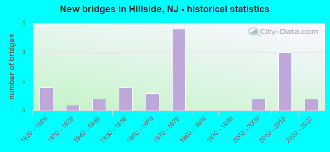
- New bridges - historical statistics
- 41920-1929
- 11930-1939
- 21940-1949
- 41950-1959
- 31960-1969
- 141970-1979
- 22000-2009
- 102010-2019
- 22020-2022
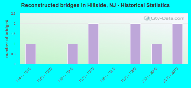
- Reconstructed bridges - Historical Statistics
- 11940-1949
- 01950-1959
- 11960-1969
- 21970-1979
- 01980-1989
- 21990-1999
- 12000-2009
- 22010-2019
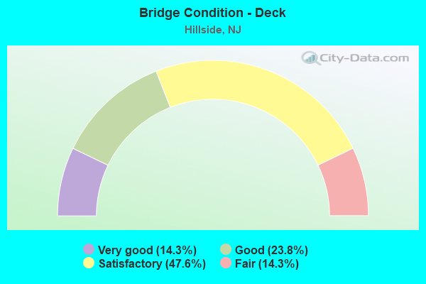
- Bridge Condition - Deck
- 14.3%Very good
- 23.8%Good
- 47.6%Satisfactory
- 14.3%Fair
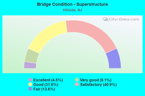
- Bridge Condition - Superstructure
- 4.5%Excellent
- 9.1%Very good
- 31.8%Good
- 40.9%Satisfactory
- 13.6%Fair
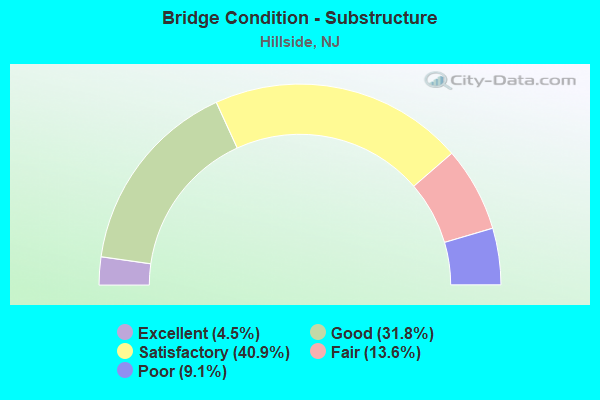
- Bridge Condition - Substructure
- 4.5%Excellent
- 31.8%Good
- 40.9%Satisfactory
- 13.6%Fair
- 9.1%Poor
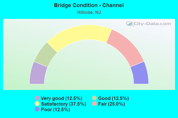
- Bridge Condition - Channel
- 12.5%Very good
- 12.5%Good
- 37.5%Satisfactory
- 25.0%Fair
- 12.5%Poor
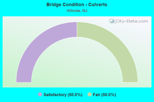
- Bridge Condition - Culverts
- 50.0%Satisfactory
- 50.0%Fair
Find on map >> Show street view
Structure Number: 2004151, Location: .8 MI E OF GSP/RT 82 JCT (Lat: 40.697750, Lng: -74.246589), Route carried "on" structure: US 22, Year Built: 1928, Year Reconstructed: 1940, Status: Open, Structure Length: 2.19m (7.19ft), Average Daily Traffic: 71,800 (year 2021), Truck Traffic: 4%, Average Future Daily Traffic: 86,200 (year 2041), Features Intersected: ELIZABETH RIVER
Minimum Vertical Clearance: 30+ m (98+ ft), Kilometerpoint: 90.928, Lanes on structure: 4, Base Highway Network: Yes, Owner: State Highway Agency, Approaching Roadway Width: 18.3m (60.0ft), Skew: 32 degrees, Material/Design: Steel, Design/Construction: Stringer/Multi-beam, Number Of Spans In Main Unit: 1, Length of Maximum Span: 20.7m (67.9ft), Curb or Sidewalk Widths: Left: 3.0m (9.8ft), Right: 3.0m (9.8ft), Curb-To-Curb Width: 17.7m (58.1ft), Out-to-Out Width: 25.1m (82.3ft)
Condition: Deck: Fair, Superstructure: Satisfactory, Substructure: Poor, Channel: Poor, Operating Rating: 48.1 metric tons, Method Used To Determine Operating Rating: Load Factor (LF), Inventory Rating: 29.0 metric tons, Method Used To Determine Inventory Rating: Load Factor (LF), Structural Evaluation: Meets minimum limits, Deck Geometry: Somewhat better than minimum adequacy, Waterway Adequacy: Equal to present minimum criteria, Approach Roadway Alignment: Equal to present desirable criteria, Length Of Structure Improvement: 2.19m (7.19ft), Designated Inspection Frequency: Every 24 months, Underwater Inspection Frequency: Every 24 months, Inspection Date: October 2021, Underwater Inspection Date: September 2021, Total Project Cost: $652,000 ( Estimate for 2021), Deck Structure Type: Concrete Cast-file-Place, Wearing Surface/Protective System: Wearing Surface: Bituminous, Membrane: Other
Find on map >> Show street view
Structure Number: 2004152, Location: 0.51 MI SOUTH OF CR 509 (Lat: 40.699011, Lng: -74.239200), Route carried "on" structure: County highway 631, Year Built: 1940, Status: Open, Structure Length: 2.35m (7.71ft), Average Daily Traffic: 13,205 (year 2021), Truck Traffic: 4%, Average Future Daily Traffic: 16,113 (year 2041), Features Intersected: US 22, Facility Carried by Structure: BLOY STREET
Minimum Vertical Clearance: 30+ m (98+ ft), Kilometerpoint: 0.595, Lanes on structure: 2, Lanes under structure: 4, Owner: State Highway Agency, Approaching Roadway Width: 9.1m (29.9ft), Material/Design: Steel, Design/Construction: Stringer/Multi-beam, Number Of Spans In Main Unit: 1, Length of Maximum Span: 22.6m (74.1ft), Curb or Sidewalk Widths: Left: 1.9m (6.2ft), Right: 1.9m (6.2ft), Curb-To-Curb Width: 9.2m (30.2ft), Out-to-Out Width: 13.7m (44.9ft)
Condition: Deck: Fair, Superstructure: Satisfactory, Substructure: Poor, Operating Rating: 58.1 metric tons, Method Used To Determine Operating Rating: Load Factor (LF), Inventory Rating: 34.5 metric tons, Method Used To Determine Inventory Rating: Load Factor (LF), Structural Evaluation: Meets minimum limits, Deck Geometry: High priority of corrective action, Underclear: Meets minimum limits, Approach Roadway Alignment: Equal to present minimum criteria, Length Of Structure Improvement: 3.05m (10.01ft), Designated Inspection Frequency: Every 24 months, Inspection Date: June 2021, Bridge Improvement Cost: $1,814,000, Roadway Improvement Cost: $120,000, Total Project Cost: $2,644,000 ( Estimate for 2019), Deck Structure Type: Concrete Cast-file-Place, Wearing Surface/Protective System: Wearing Surface: Bituminous
Find on map >> Show street view
Structure Number: 2004155, Location: 1.42 MI WEST OF NJ27 JCT (Lat: 40.696361, Lng: -74.216811), Route carried "on" structure: City street , Year Built: 2021, Status: Open, Structure Length: 4.11m (13.48ft), Average Daily Traffic: 9,692 (year 2021), Truck Traffic: 1%, Average Future Daily Traffic: 11,827 (year 2041), Design Load: HL 93, Features Intersected: US 22, Facility Carried by Structure: HILLSIDE AVE.
Minimum Vertical Clearance: 30+ m (98+ ft), Kilometerpoint: 0.000, Lanes on structure: 2, Lanes under structure: 4, Owner: State Highway Agency, Approaching Roadway Width: 9.8m (32.2ft), Material/Design: Steel, Design/Construction: Stringer/Multi-beam, Number Of Spans In Main Unit: 1, Length of Maximum Span: 39.6m (129.9ft), Curb or Sidewalk Widths: Left: 0.0m, Right: 1.8m (5.9ft), Curb-To-Curb Width: 9.8m (32.2ft), Out-to-Out Width: 12.6m (41.3ft)
Condition: Deck: Very good, Superstructure: Excellent, Substructure: Excellent, Operating Rating: 42.1 metric tons, Method Used To Determine Operating Rating: Assigned ratings based on Load and Resistance Factor Design (LRFD) reported by rating factor (RF) using HL93 loadings, Inventory Rating: 32.4 metric tons, Method Used To Determine Inventory Rating: Assigned ratings based on Load and Resistance Factor Design (LRFD) reported by rating factor (RF) using HL93 loadings, Structural Evaluation: Equal to present desirable criteria, Deck Geometry: Meets minimum limits, Underclear: Meets minimum limits, Approach Roadway Alignment: Equal to present minimum criteria, Length Of Structure Improvement: 3.35m (10.99ft), Designated Inspection Frequency: Every 24 months, Inspection Date: June 2021, Bridge Improvement Cost: $1,000, Total Project Cost: $2,000 ( Estimate for 2019), Deck Structure Type: Concrete Cast-file-Place, Wearing Surface/Protective System: Wearing Surface: Monolithic Concrete, Deck Protection: Epoxy Coated Reinforcing
Find on map >> Show street view
Structure Number: 2004157, Location: 0.53 Mi. W. of CR 601 (Lat: 40.697061, Lng: -74.216481), Route carried "on" structure: Business County highway 623, Year Built: 1929, Year Reconstructed: 1997, Status: Open, Structure Length: 1.98m (6.50ft), Average Daily Traffic: 15,900 (year 2021), Truck Traffic: 4%, Average Future Daily Traffic: 19,100 (year 2041), Design Load: HS 25 or greater, Features Intersected: US 22
Minimum Vertical Clearance: 30+ m (98+ ft), Kilometerpoint: 5.649, Lanes on structure: 2, Lanes under structure: 4, Owner: State Highway Agency, Approaching Roadway Width: 12.2m (40.0ft), Material/Design: Steel, Design/Construction: Girder and Floorbeam System, Number Of Spans In Main Unit: 1, Length of Maximum Span: 18.9m (62.0ft), Curb or Sidewalk Widths: Left: 2.9m (9.5ft), Right: 2.9m (9.5ft), Curb-To-Curb Width: 12.2m (40.0ft), Out-to-Out Width: 19.4m (63.6ft)
Condition: Deck: Good, Superstructure: Fair, Substructure: Fair, Operating Rating: 36.3 metric tons, Method Used To Determine Operating Rating: Load Factor (LF), Inventory Rating: 21.8 metric tons, Method Used To Determine Inventory Rating: Load Factor (LF), Structural Evaluation: Somewhat better than minimum adequacy, Deck Geometry: Somewhat better than minimum adequacy, Underclear: High priority of replacement, Approach Roadway Alignment: Meets minimum limits, Length Of Structure Improvement: 7.68m (25.20ft), Designated Inspection Frequency: Every 24 months, Critical Feature Inspection Frequency: Every 24 months, Inspection Date: October 2021, Critical Feature Inspection Date: October 2021, Bridge Improvement Cost: $5,444,000, Roadway Improvement Cost: $50,000, Total Project Cost: $7,605,000 ( Estimate for 2021), Deck Structure Type: Concrete Cast-file-Place, Wearing Surface/Protective System: Deck Protection: Epoxy Coated Reinforcing
Find on map >> Show street view
Structure Number: 2004163, Location: 2.95 mi West of NJ 21 Jct (Lat: 40.699200, Lng: -74.232789), Route carried "on" structure: US 22, Year Built: 2013, Status: Open, Structure Length: 2.01m (6.59ft), Average Daily Traffic: 71,845 (year 2021), Truck Traffic: 4%, Average Future Daily Traffic: 86,214 (year 2041), Design Load: HL 93, Features Intersected: ACCESS ROAD
Minimum Vertical Clearance: 30+ m (98+ ft), Kilometerpoint: 92.167, Lanes on structure: 4, Lanes under structure: 2, Base Highway Network: Yes, Owner: State Highway Agency, Approaching Roadway Width: 24.4m (80.1ft), Skew: 30 degrees, Material/Design: Steel, Design/Construction: Stringer/Multi-beam, Number Of Spans In Main Unit: 1, Length of Maximum Span: 18.6m (61.0ft), Curb or Sidewalk Widths: Left: 1.8m (5.9ft), Right: 1.8m (5.9ft), Curb-To-Curb Width: 24.4m (80.1ft), Out-to-Out Width: 29.4m (96.5ft)
Condition: Deck: Very good, Superstructure: Very good, Substructure: Good, Operating Rating: 93.0 metric tons, Method Used To Determine Operating Rating: Load and Resistance Factor Rating (LRFR) rating reported by rating factor(RF) method using HL-93 loadings, Inventory Rating: 74.8 metric tons, Method Used To Determine Inventory Rating: Load and Resistance Factor Rating (LRFR) rating reported by rating factor(RF) method using HL-93 loadings, Structural Evaluation: Better than present minimum criteria, Deck Geometry: Superior to present desirable criteria, Underclear: Equal to present minimum criteria, Approach Roadway Alignment: Better than present minimum criteria, Designated Inspection Frequency: Every 24 months, Inspection Date: March 2021, Deck Structure Type: Concrete Cast-file-Place, Wearing Surface/Protective System: Deck Protection: Epoxy Coated Reinforcing
Find on map >> Show street view
Structure Number: 2004164, Location: 2 MI EAST OF PARKWAY (Lat: 40.699169, Lng: -74.231669), Route carried "on" structure: US 22, Year Built: 2013, Status: Open, Structure Length: 8.35m (27.40ft), Average Daily Traffic: 73,182 (year 2021), Truck Traffic: 4%, Average Future Daily Traffic: 87,818 (year 2041), Design Load: HL 93, Features Intersected: LIBERTY AVE & CONRAIL
Minimum Vertical Clearance: 30+ m (98+ ft), Kilometerpoint: 92.232, Lanes on structure: 4, Lanes under structure: 3, Base Highway Network: Yes, Owner: State Highway Agency, Approaching Roadway Width: 24.4m (80.1ft), Skew: 39 degrees, Material/Design: Steel, Design/Construction: Stringer/Multi-beam, Number Of Spans In Main Unit: 3, Length of Maximum Span: 39.3m (128.9ft), Curb or Sidewalk Widths: Left: 1.8m (5.9ft), Right: 1.8m (5.9ft), Curb-To-Curb Width: 24.4m (80.1ft), Out-to-Out Width: 29.4m (96.5ft)
Condition: Deck: Very good, Superstructure: Very good, Substructure: Good, Operating Rating: 87.8 metric tons, Method Used To Determine Operating Rating: Load and Resistance Factor Rating (LRFR) rating reported by rating factor(RF) method using HL-93 loadings, Inventory Rating: 67.7 metric tons, Method Used To Determine Inventory Rating: Load and Resistance Factor Rating (LRFR) rating reported by rating factor(RF) method using HL-93 loadings, Structural Evaluation: Better than present minimum criteria, Deck Geometry: Superior to present desirable criteria, Underclear: Somewhat better than minimum adequacy, Approach Roadway Alignment: Equal to present desirable criteria, Designated Inspection Frequency: Every 24 months, Inspection Date: March 2021, Deck Structure Type: Concrete Cast-file-Place, Wearing Surface/Protective System: Deck Protection: Epoxy Coated Reinforcing
Find on map >> Show street view
Structure Number: 200702, Location: NEAR CONANT STREET (Lat: 40.689739, Lng: -74.237919), Route carried "on" structure: County highway 509, Year Built: 2005, Status: Open, Structure Length: 2.68m (8.79ft), Average Daily Traffic: 8,082 (year 2020), Truck Traffic: 4%, Average Future Daily Traffic: 9,862 (year 2040), Design Load: HS 25 or greater, Features Intersected: ELIZABETH RIVER
Minimum Vertical Clearance: 30+ m (98+ ft), Kilometerpoint: 22.965, Lanes on structure: 4, Owner: County Highway Agency, Approaching Roadway Width: 14.0m (45.9ft), Material/Design: Steel, Design/Construction: Stringer/Multi-beam, Number Of Spans In Main Unit: 1, Length of Maximum Span: 25.0m (82.0ft), Curb or Sidewalk Widths: Left: 1.6m (5.2ft), Right: 1.6m (5.2ft), Curb-To-Curb Width: 14.0m (45.9ft), Out-to-Out Width: 18.0m (59.1ft)
Condition: Deck: Good, Superstructure: Good, Substructure: Good, Channel: Good, Inventory Rating: 75.3 metric tons, Method Used To Determine Inventory Rating: Load Factor (LF), Structural Evaluation: Better than present minimum criteria, Deck Geometry: High priority of replacement, Waterway Adequacy: Superior to present desirable criteria, Approach Roadway Alignment: Better than present minimum criteria, Length Of Structure Improvement: 2.68m (8.79ft), Designated Inspection Frequency: Every 24 months, Inspection Date: March 2020, Bridge Improvement Cost: $131,000, Roadway Improvement Cost: $26,000, Total Project Cost: $225,000 ( Estimate for 2020), Deck Structure Type: Concrete Cast-file-Place, Wearing Surface/Protective System: Wearing Surface: Epoxy Overlay, Deck Protection: Galvanized Reinforcing
Find on map >> Show street view
Structure Number: 2007032, Location: AT CONRAIL OVERPASS (Lat: 40.689261, Lng: -74.229000), Route carried "on" structure: County highway 630, Year Built: 1930, Status: Open, Structure Length: 0.61m (2.00ft), Average Daily Traffic: 5,422 (year 2020), Truck Traffic: 4%, Average Future Daily Traffic: 6,616 (year 2040), Features Intersected: STREAM 8-5
Minimum Vertical Clearance: 30+ m (98+ ft), Kilometerpoint: 7.194, Lanes on structure: 2, Owner: Town or Township Highway Agency, Approaching Roadway Width: 9.1m (29.9ft), Skew: 9 degrees, Material/Design: Concrete, Design/Construction: Culvert, Number Of Spans In Main Unit: 1, Length of Maximum Span: 6.1m (20.0ft), Curb or Sidewalk Widths: Left: 1.5m (4.9ft), Right: 1.5m (4.9ft)
Condition: Channel: Fair, Culverts: Fair, Operating Rating: 39.0 metric tons, Method Used To Determine Operating Rating: Field evaluation and documented engineering judgment, Inventory Rating: 23.6 metric tons, Method Used To Determine Inventory Rating: Field evaluation and documented engineering judgment, Structural Evaluation: Somewhat better than minimum adequacy, Waterway Adequacy: Equal to present desirable criteria, Approach Roadway Alignment: Better than present minimum criteria, Designated Inspection Frequency: Every 24 months, Underwater Inspection Frequency: Every 24 months, Inspection Date: March 2020, Underwater Inspection Date: March 2020
Find on map >> Show street view
Structure Number: 201116, Location: 5.51 MI WEST OF I-95 (Lat: 40.705131, Lng: -74.246361), Route carried "on" structure: Interstate 78, Year Built: 1976, Year Reconstructed: 2010, Status: Open, Structure Length: 7.92m (25.98ft), Average Daily Traffic: 236,890 (year 2021), Truck Traffic: 9%, Average Future Daily Traffic: 284,265 (year 2041), Design Load: HS 20, Features Intersected: GARDEN STATE PARKWAY
Minimum Vertical Clearance: 30+ m (98+ ft), Kilometerpoint: 85.931, Lanes on structure: 12, Lanes under structure: 13, Base Highway Network: Yes, Owner: State Highway Agency, Approaching Roadway Width: 61.9m (203.1ft), Skew: 30 degrees, Material/Design: Steel, Design/Construction: Stringer/Multi-beam, Number Of Spans In Main Unit: 2, Length of Maximum Span: 41.1m (134.8ft), Curb-To-Curb Width: 61.8m (202.8ft), Out-to-Out Width: 62.8m (206.0ft)
Condition: Deck: Good, Superstructure: Good, Substructure: Satisfactory, Operating Rating: 47.2 metric tons, Method Used To Determine Operating Rating: Load Factor (LF), Inventory Rating: 28.1 metric tons, Method Used To Determine Inventory Rating: Load Factor (LF), Structural Evaluation: Equal to present minimum criteria, Deck Geometry: Superior to present desirable criteria, Underclear: Meets minimum limits, Approach Roadway Alignment: Better than present minimum criteria, Designated Inspection Frequency: Every 24 months, Inspection Date: June 2021, Deck Structure Type: Concrete Cast-file-Place, Wearing Surface/Protective System: Wearing Surface: Latex Concrete
Find on map >> Show street view
Structure Number: 2011162, Location: 0.10 MI EAST OF GSP JCT (Lat: 40.704931, Lng: -74.244731), Route carried "on" structure: Interstate 78, Year Built: 1976, Year Reconstructed: 2010, Status: Open, Structure Length: 5.33m (17.49ft), Average Daily Traffic: 189,710 (year 2021), Truck Traffic: 9%, Average Future Daily Traffic: 227,652 (year 2041), Design Load: HS 20, Features Intersected: GLENWOOD AVENUE&CONRAIL
Minimum Vertical Clearance: 30+ m (98+ ft), Kilometerpoint: 85.928, Lanes on structure: 11, Lanes under structure: 2, Base Highway Network: Yes, Owner: State Highway Agency, Approaching Roadway Width: 59.7m (195.9ft), Skew: 31 degrees, Material/Design: Steel, Design/Construction: Stringer/Multi-beam, Number Of Spans In Main Unit: 2, Length of Maximum Span: 28.0m (91.9ft), Curb-To-Curb Width: 59.8m (196.2ft), Out-to-Out Width: 63.8m (209.3ft)
Condition: Deck: Satisfactory, Superstructure: Good, Substructure: Satisfactory, Operating Rating: 58.1 metric tons, Method Used To Determine Operating Rating: Load Factor (LF), Inventory Rating: 34.5 metric tons, Method Used To Determine Inventory Rating: Load Factor (LF), Structural Evaluation: Equal to present minimum criteria, Deck Geometry: Superior to present desirable criteria, Underclear: Somewhat better than minimum adequacy, Approach Roadway Alignment: Equal to present desirable criteria, Designated Inspection Frequency: Every 24 months, Inspection Date: June 2021, Deck Structure Type: Concrete Cast-file-Place, Wearing Surface/Protective System: Wearing Surface: Latex Concrete
Find on map >> Show street view
Structure Number: 2011164, Location: 0.3 MI EAST OF GSP (Lat: 40.705331, Lng: -74.241400), Route carried "on" structure: Interstate 78, Year Built: 1976, Year Reconstructed: 2009, Status: Open, Structure Length: 5.03m (16.50ft), Average Daily Traffic: 184,314 (year 2021), Truck Traffic: 9%, Average Future Daily Traffic: 221,177 (year 2041), Design Load: HS 20+Mod, Features Intersected: LEHIGH VALLEY RR
Minimum Vertical Clearance: 30+ m (98+ ft), Kilometerpoint: 86.293, Lanes on structure: 11, Base Highway Network: Yes, Owner: State Highway Agency, Approaching Roadway Width: 60.7m (199.1ft), Skew: 24 degrees, Material/Design: Steel, Design/Construction: Stringer/Multi-beam, Number Of Spans In Main Unit: 3, Length of Maximum Span: 29.6m (97.1ft), Curb or Sidewalk Widths: Left: 0.2m (0.7ft), Right: 0.2m (0.7ft), Curb-To-Curb Width: 60.2m (197.5ft), Out-to-Out Width: 65.4m (214.6ft)
Condition: Deck: Satisfactory, Superstructure: Good, Substructure: Satisfactory, Operating Rating: 59.9 metric tons, Method Used To Determine Operating Rating: Load Factor (LF), Inventory Rating: 35.4 metric tons, Method Used To Determine Inventory Rating: Load Factor (LF), Structural Evaluation: Equal to present minimum criteria, Deck Geometry: Superior to present desirable criteria, Underclear: Somewhat better than minimum adequacy, Approach Roadway Alignment: Better than present minimum criteria, Designated Inspection Frequency: Every 24 months, Inspection Date: April 2021, Deck Structure Type: Concrete Cast-file-Place, Wearing Surface/Protective System: Wearing Surface: Latex Concrete
Find on map >> Show street view
Structure Number: 2011165, Location: 0.25 MI EAST OF GSP JCT (Lat: 40.704911, Lng: -74.239639), Route carried "on" structure: Interstate 78, Year Built: 1976, Status: Open, Structure Length: 0.91m (2.99ft), Average Daily Traffic: 184,313 (year 2021), Truck Traffic: 9%, Average Future Daily Traffic: 221,176 (year 2041), Design Load: HS 20+Mod, Features Intersected: CONRAIL RR (ABANDONED)
Minimum Vertical Clearance: 30+ m (98+ ft), Kilometerpoint: 86.373, Lanes on structure: 10, Base Highway Network: Yes, Owner: State Highway Agency, Approaching Roadway Width: 55.2m (181.1ft), Skew: 33 degrees, Material/Design: Concrete, Design/Construction: Frame, Number Of Spans In Main Unit: 1, Length of Maximum Span: 6.4m (21.0ft), Curb or Sidewalk Widths: Left: 0.2m (0.7ft), Right: 0.2m (0.7ft), Curb-To-Curb Width: 54.5m (178.8ft), Out-to-Out Width: 59.0m (193.6ft)
Condition: Superstructure: Good, Substructure: Good, Inventory Rating: 86.2 metric tons, Method Used To Determine Inventory Rating: Load Factor (LF), Structural Evaluation: Better than present minimum criteria, Deck Geometry: Superior to present desirable criteria, Underclear: Meets minimum limits, Approach Roadway Alignment: Equal to present desirable criteria, Designated Inspection Frequency: Every 24 months, Inspection Date: August 2021
Find on map >> Show street view
Structure Number: 2011166, Location: 0.41 MI EAST OF GSP (Lat: 40.705069, Lng: -74.238511), Route carried "on" structure: Interstate 78, Year Built: 1976, Status: Open, Structure Length: 6.04m (19.82ft), Average Daily Traffic: 75,796 (year 2021), Truck Traffic: 9%, Average Future Daily Traffic: 90,955 (year 2041), Design Load: HS 20+Mod, Features Intersected: RAMSEY AVENUE
Minimum Vertical Clearance: 30+ m (98+ ft), Kilometerpoint: 86.600, Lanes on structure: 10, Lanes under structure: 2, Base Highway Network: Yes, Owner: State Highway Agency, Approaching Roadway Width: 54.6m (179.1ft), Skew: 35 degrees, Material/Design: Steel, Design/Construction: Stringer/Multi-beam, Number Of Spans In Main Unit: 3, Length of Maximum Span: 45.4m (149.0ft), Curb or Sidewalk Widths: Left: 0.2m (0.7ft), Right: 0.2m (0.7ft), Curb-To-Curb Width: 54.5m (178.8ft), Out-to-Out Width: 59.0m (193.6ft)
Condition: Deck: Good, Superstructure: Satisfactory, Substructure: Fair, Operating Rating: 50.8 metric tons, Method Used To Determine Operating Rating: Load Factor (LF), Inventory Rating: 30.8 metric tons, Method Used To Determine Inventory Rating: Load Factor (LF), Structural Evaluation: Somewhat better than minimum adequacy, Deck Geometry: Superior to present desirable criteria, Underclear: Better than present minimum criteria, Approach Roadway Alignment: Equal to present desirable criteria, Designated Inspection Frequency: Every 24 months, Inspection Date: May 2021, Deck Structure Type: Concrete Cast-file-Place, Wearing Surface/Protective System: Wearing Surface: Bituminous
Find on map >> Show street view
Structure Number: 2011167, Location: 0.7 MI E OF GSP&I78 JCT (Lat: 40.706911, Lng: -74.233131), Route carried "on" structure: County highway 509, Year Built: 1975, Status: Open, Structure Length: 9.75m (31.99ft), Average Daily Traffic: 8,080 (year 2020), Truck Traffic: 4%, Average Future Daily Traffic: 9,700 (year 2040), Design Load: HS 20+Mod, Features Intersected: I-78
Minimum Vertical Clearance: 30+ m (98+ ft), Kilometerpoint: 25.363, Lanes on structure: 2, Lanes under structure: 11, Owner: State Highway Agency, Approaching Roadway Width: 14.0m (45.9ft), Skew: 4 degrees, Material/Design: Steel, Design/Construction: Stringer/Multi-beam, Number Of Spans In Main Unit: 4, Length of Maximum Span: 27.1m (88.9ft), Curb or Sidewalk Widths: Left: 1.8m (5.9ft), Right: 1.8m (5.9ft), Curb-To-Curb Width: 14.0m (45.9ft), Out-to-Out Width: 18.4m (60.4ft)
Condition: Deck: Satisfactory, Superstructure: Good, Substructure: Satisfactory, Operating Rating: 63.5 metric tons, Method Used To Determine Operating Rating: Load Factor (LF), Inventory Rating: 38.1 metric tons, Method Used To Determine Inventory Rating: Load Factor (LF), Structural Evaluation: Equal to present minimum criteria, Deck Geometry: Superior to present desirable criteria, Underclear: High priority of corrective action, Approach Roadway Alignment: Equal to present desirable criteria, Length Of Structure Improvement: 9.75m (31.99ft), Designated Inspection Frequency: Every 24 months, Inspection Date: July 2020, Bridge Improvement Cost: $1,305,000, Roadway Improvement Cost: $238,000, Total Project Cost: $1,890,000 ( Estimate for 2020), Deck Structure Type: Concrete Cast-file-Place
Find on map >> Show street view
Structure Number: 201117, Location: 0.9 MI EAST OF GSP JCT (Lat: 40.708431, Lng: -74.229739), Route carried "on" structure: City street , Year Built: 1976, Status: Open, Structure Length: 11.13m (36.52ft), Average Daily Traffic: 5,875 (year 2021), Truck Traffic: 1%, Average Future Daily Traffic: 7,050 (year 2041), Design Load: HS 20+Mod, Features Intersected: I-78, Facility Carried by Structure: WINANS AVENUE
Minimum Vertical Clearance: 30+ m (98+ ft), Kilometerpoint: 0.000, Lanes on structure: 3, Lanes under structure: 12, Owner: State Highway Agency, Approaching Roadway Width: 15.2m (49.9ft), Skew: 2 degrees, Material/Design: Steel, Design/Construction: Stringer/Multi-beam, Number Of Spans In Main Unit: 4, Length of Maximum Span: 35.7m (117.1ft), Curb or Sidewalk Widths: Left: 1.8m (5.9ft), Right: 1.8m (5.9ft), Curb-To-Curb Width: 15.2m (49.9ft), Out-to-Out Width: 19.7m (64.6ft)
Condition: Deck: Fair, Superstructure: Satisfactory, Substructure: Satisfactory, Operating Rating: 75.3 metric tons, Method Used To Determine Operating Rating: Load Factor (LF), Inventory Rating: 45.4 metric tons, Method Used To Determine Inventory Rating: Load Factor (LF), Structural Evaluation: Equal to present minimum criteria, Deck Geometry: Equal to present minimum criteria, Underclear: High priority of corrective action, Approach Roadway Alignment: Equal to present desirable criteria, Length Of Structure Improvement: 11.13m (36.52ft), Designated Inspection Frequency: Every 24 months, Inspection Date: May 2021, Roadway Improvement Cost: $598,000, Total Project Cost: $772,000 ( Estimate for 2021), Deck Structure Type: Concrete Cast-file-Place, Wearing Surface/Protective System: Wearing Surface: Monolithic Concrete
Find on map >> Show street view
Structure Number: 201904, Location: 0.05 MI SW OF GSP AT 142A (Lat: 40.707181, Lng: -74.247169), Route carried "on" structure: City street , Year Built: 2004, Status: Open, Structure Length: 1.37m (4.49ft), Average Daily Traffic: 4,724 (year 2020), Truck Traffic: 3%, Average Future Daily Traffic: 5,765 (year 2040), Design Load: HS 20+Mod, Features Intersected: ELIZABETH RIVER, Facility Carried by Structure: UNION AVENUE
Minimum Vertical Clearance: 30+ m (98+ ft), Kilometerpoint: 1.110, Lanes on structure: 2, Owner: County Highway Agency, Approaching Roadway Width: 10.4m (34.1ft), Skew: 3 degrees, Material/Design: Concrete, Design/Construction: Culvert, Number Of Spans In Main Unit: 2, Length of Maximum Span: 4.9m (16.1ft), Curb or Sidewalk Widths: Left: 2.2m (7.2ft), Right: 2.2m (7.2ft), Curb-To-Curb Width: 10.4m (34.1ft), Out-to-Out Width: 15.2m (49.9ft)
Condition: Channel: Satisfactory, Culverts: Satisfactory, Operating Rating: 68.0 metric tons, Method Used To Determine Operating Rating: Field evaluation and documented engineering judgment, Inventory Rating: 40.8 metric tons, Method Used To Determine Inventory Rating: Field evaluation and documented engineering judgment, Structural Evaluation: Equal to present minimum criteria, Deck Geometry: Somewhat better than minimum adequacy, Waterway Adequacy: Better than present minimum criteria, Approach Roadway Alignment: Better than present minimum criteria, Designated Inspection Frequency: Every 24 months, Inspection Date: March 2020, Deck Structure Type: Concrete Cast-file-Place, Wearing Surface/Protective System: Wearing Surface: Bituminous, Deck Protection: Epoxy Coated Reinforcing
Find on map >> Show street view
Structure Number: 2053162, Location: 2.0MI E OF US22&GSP JCT (Lat: 40.695969, Lng: -74.220289), Route carried "on" structure: City street , Year Built: 1966, Status: Open, Structure Length: 27.58m (90.49ft), Average Daily Traffic: 3,174 (year 2021), Truck Traffic: 1%, Average Future Daily Traffic: 3,873 (year 2041), Design Load: HS 20+Mod, Features Intersected: LEHIGH VALLEY (CONRAIL), Facility Carried by Structure: CENTRAL AVENUE
Minimum Vertical Clearance: 30+ m (98+ ft), Kilometerpoint: 0.000, Lanes on structure: 2, Maintenance Responsibility: State Highway Agency, Approaching Roadway Width: 9.1m (29.9ft), Skew: 5 degrees, Material/Design: Prestressed concrete, Design/Construction: Stringer/Multi-beam, Number Of Spans In Main Unit: 14, Length of Maximum Span: 28.3m (92.8ft), Curb or Sidewalk Widths: Left: 0.5m (1.6ft), Right: 1.8m (5.9ft), Curb-To-Curb Width: 9.1m (29.9ft), Out-to-Out Width: 12.1m (39.7ft)
Condition: Deck: Satisfactory, Superstructure: Satisfactory, Substructure: Satisfactory, Operating Rating: 64.4 metric tons, Method Used To Determine Operating Rating: Load Factor (LF), Inventory Rating: 20.0 metric tons, Method Used To Determine Inventory Rating: Load Factor (LF), Structural Evaluation: Somewhat better than minimum adequacy, Deck Geometry: Meets minimum limits, Underclear: Meets minimum limits, Approach Roadway Alignment: Equal to present minimum criteria, Designated Inspection Frequency: Every 24 months, Inspection Date: September 2021, Deck Structure Type: Concrete Cast-file-Place, Wearing Surface/Protective System: Wearing Surface: Monolithic Concrete
Find on map >> Show street view
Structure Number: 2063163, Location: 1 mi North of NJ 439 (Lat: 40.696631, Lng: -74.216189), Route carried "on" structure: County highway 623, Year Built: 1929, Year Reconstructed: 1997, Status: Open, Structure Length: 4.79m (15.72ft), Average Daily Traffic: 15,800 (year 2020), Truck Traffic: 4%, Average Future Daily Traffic: 19,280 (year 2040), Features Intersected: LEHIGH VALLY ML
Minimum Vertical Clearance: 30+ m (98+ ft), Kilometerpoint: 5.617, Lanes on structure: 2, Maintenance Responsibility: State Highway Agency, Approaching Roadway Width: 12.2m (40.0ft), Material/Design: Steel, Design/Construction: Girder and Floorbeam System, Number Of Spans In Main Unit: 1, Number Of Approach Spans: 3, Length of Maximum Span: 27.4m (89.9ft), Curb or Sidewalk Widths: Left: 2.8m (9.2ft), Right: 2.8m (9.2ft), Curb-To-Curb Width: 12.2m (40.0ft), Out-to-Out Width: 12.4m (40.7ft)
Condition: Deck: Satisfactory, Superstructure: Fair, Substructure: Fair, Operating Rating: 58.1 metric tons, Method Used To Determine Operating Rating: Load Factor (LF), Inventory Rating: 34.5 metric tons, Method Used To Determine Inventory Rating: Load Factor (LF), Structural Evaluation: Somewhat better than minimum adequacy, Deck Geometry: Somewhat better than minimum adequacy, Underclear: Somewhat better than minimum adequacy, Approach Roadway Alignment: Equal to present minimum criteria, Designated Inspection Frequency: Every 24 months, Critical Feature Inspection Frequency: Every 24 months, Inspection Date: November 2020, Critical Feature Inspection Date: November 2020, Deck Structure Type: Concrete Cast-file-Place, Wearing Surface/Protective System: Wearing Surface: Monolithic Concrete
Find on map >> Show street view
Structure Number: 361424S, Location: 0.4 MI S OF I-78& GSP JCT (Lat: 40.701589, Lng: -74.248969), Route carried "on" structure: Other road GSP, Year Built: 1954, Year Reconstructed: 1984, Status: Open, Structure Length: 5.09m (16.70ft), Average Daily Traffic: 111,191 (year 2021), Truck Traffic: 1%, Average Future Daily Traffic: 158,625 (year 2041), Design Load: HS 20, Features Intersected: ELIZABETH RIVER, Facility Carried by Structure: GARDEN ST PKWY SB
Minimum Vertical Clearance: 30+ m (98+ ft), Kilometerpoint: 229.332, Lanes on structure: 5, Base Highway Network: Yes, Toll: On toll road, Owner: State Toll Authority, Approaching Roadway Width: 25.9m (85.0ft), Skew: 3 degrees, Material/Design: Steel, Design/Construction: Stringer/Multi-beam, Number Of Spans In Main Unit: 2, Length of Maximum Span: 24.4m (80.1ft), Curb-To-Curb Width: 21.0m (68.9ft), Out-to-Out Width: 21.9m (71.9ft)
Condition: Deck: Satisfactory, Superstructure: Satisfactory, Substructure: Good, Channel: Fair, Operating Rating: 56.1 metric tons, Method Used To Determine Operating Rating: Load and Resistance Factor Rating (LRFR) rating reported by rating factor(RF) method using HL-93 loadings, Inventory Rating: 43.1 metric tons, Method Used To Determine Inventory Rating: Load and Resistance Factor Rating (LRFR) rating reported by rating factor(RF) method using HL-93 loadings, Structural Evaluation: Equal to present minimum criteria, Deck Geometry: Meets minimum limits, Waterway Adequacy: Equal to present desirable criteria, Approach Roadway Alignment: Equal to present desirable criteria, Designated Inspection Frequency: Every 24 months, Inspection Date: August 2021, Deck Structure Type: Concrete Cast-file-Place, Wearing Surface/Protective System: Wearing Surface: Bituminous, Membrane: Preformed Fabric
Find on map >> Show street view
Structure Number: 361425N, Location: 0.4 MI S OF I-78& GSP JCT (Lat: 40.701031, Lng: -74.249131), Route carried "on" structure: Other road GSP, Year Built: 1952, Year Reconstructed: 1984, Status: Open, Structure Length: 5.03m (16.50ft), Average Daily Traffic: 120,168 (year 2021), Truck Traffic: 1%, Average Future Daily Traffic: 172,047 (year 2041), Design Load: HS 20, Features Intersected: ELIZABETH RIVER, Facility Carried by Structure: GARDEN ST PKWY NB
Minimum Vertical Clearance: 30+ m (98+ ft), Kilometerpoint: 229.332, Lanes on structure: 5, Base Highway Network: Yes, Toll: On toll road, Owner: State Toll Authority, Approaching Roadway Width: 21.0m (68.9ft), Skew: 3 degrees, Material/Design: Steel, Design/Construction: Stringer/Multi-beam, Number Of Spans In Main Unit: 2, Length of Maximum Span: 24.4m (80.1ft), Curb-To-Curb Width: 21.0m (68.9ft), Out-to-Out Width: 21.9m (71.9ft)
Condition: Deck: Satisfactory, Superstructure: Satisfactory, Substructure: Satisfactory, Channel: Satisfactory, Operating Rating: 51.2 metric tons, Method Used To Determine Operating Rating: Load and Resistance Factor Rating (LRFR) rating reported by rating factor(RF) method using HL-93 loadings, Inventory Rating: 39.5 metric tons, Method Used To Determine Inventory Rating: Load and Resistance Factor Rating (LRFR) rating reported by rating factor(RF) method using HL-93 loadings, Structural Evaluation: Equal to present minimum criteria, Deck Geometry: Meets minimum limits, Waterway Adequacy: Equal to present desirable criteria, Approach Roadway Alignment: Equal to present desirable criteria, Designated Inspection Frequency: Every 24 months, Inspection Date: August 2021, Deck Structure Type: Concrete Cast-file-Place, Wearing Surface/Protective System: Wearing Surface: Bituminous, Membrane: Preformed Fabric
Find on map >> Show street view
Structure Number: 361428A, Location: 0.1 MI E OF GSP &I78 JCT (Lat: 40.704828, Lng: -74.244525), Route carried "on" structure: Ramp Other road GSP, Year Built: 1968, Status: Open, Structure Length: 4.88m (16.01ft), Average Daily Traffic: 18,293 (year 2021), Truck Traffic: 1%, Average Future Daily Traffic: 22,322 (year 2041), Design Load: HS 20+Mod, Features Intersected: GLENWOOD AVE&CECO SDG RR, Facility Carried by Structure: RAMP GA
Minimum Vertical Clearance: 30+ m (98+ ft), Kilometerpoint: 229.814, Lanes on structure: 1, Lanes under structure: 2, Toll: On toll road, Owner: State Toll Authority, Approaching Roadway Width: 8.5m (27.9ft), Skew: 1 degrees, Material/Design: Steel, Design/Construction: Stringer/Multi-beam, Number Of Spans In Main Unit: 2, Length of Maximum Span: 24.7m (81.0ft), Curb or Sidewalk Widths: Left: 0.4m (1.3ft), Right: 0.4m (1.3ft), Curb-To-Curb Width: 8.8m (28.9ft), Out-to-Out Width: 10.4m (34.1ft)
Condition: Deck: Satisfactory, Superstructure: Good, Substructure: Satisfactory, Operating Rating: 48.9 metric tons, Method Used To Determine Operating Rating: Load and Resistance Factor Rating (LRFR) rating reported by rating factor(RF) method using HL-93 loadings, Inventory Rating: 37.6 metric tons, Method Used To Determine Inventory Rating: Load and Resistance Factor Rating (LRFR) rating reported by rating factor(RF) method using HL-93 loadings, Structural Evaluation: Equal to present minimum criteria, Deck Geometry: Superior to present desirable criteria, Underclear: Superior to present desirable criteria, Approach Roadway Alignment: Equal to present desirable criteria, Designated Inspection Frequency: Every 24 months, Inspection Date: July 2021, Deck Structure Type: Concrete Cast-file-Place, Wearing Surface/Protective System: Wearing Surface: Monolithic Concrete
Find on map >> Show street view
Structure Number: 361429, Location: 0.14 M N OF GSP/I-78 (Lat: 40.709028, Lng: -74.244953), Route carried "on" structure: Ramp Other road GSP, Year Built: 2011, Status: Open, Structure Length: 41.70m (136.81ft), Average Daily Traffic: 21,226 (year 2021), Truck Traffic: 1%, Average Future Daily Traffic: 25,900 (year 2041), Design Load: HS 25 or greater, Features Intersected: GSP,UNI AVE,RampC&F,ACCE
Minimum Vertical Clearance: 30+ m (98+ ft), Kilometerpoint: 229.975, Lanes on structure: 2, Lanes under structure: 14, Toll: On toll road, Owner: State Toll Authority, Approaching Roadway Width: 10.4m (34.1ft), Skew: 1 degrees, Material/Design: Steel continuous, Design/Construction: Stringer/Multi-beam, Number Of Spans In Main Unit: 9, Length of Maximum Span: 53.9m (176.8ft), Curb-To-Curb Width: 10.4m (34.1ft), Out-to-Out Width: 11.5m (37.7ft)
Condition: Deck: Good, Superstructure: Satisfactory, Substructure: Good, Channel: Very good, Operating Rating: 46.7 metric tons, Method Used To Determine Operating Rating: Load and Resistance Factor Rating (LRFR) rating reported by rating factor(RF) method using HL-93 loadings, Inventory Rating: 32.7 metric tons, Method Used To Determine Inventory Rating: Load and Resistance Factor Rating (LRFR) rating reported by rating factor(RF) method using HL-93 loadings, Structural Evaluation: Equal to present minimum criteria, Deck Geometry: Better than present minimum criteria, Underclear: High priority of corrective action, Waterway Adequacy: Equal to present desirable criteria, Approach Roadway Alignment: Equal to present minimum criteria, Length Of Structure Improvement: 41.61m (136.52ft), Designated Inspection Frequency: Every 24 months, Critical Feature Inspection Frequency: Every 24 months, Inspection Date: August 2021, Critical Feature Inspection Date: August 2021, Bridge Improvement Cost: $500,000, Roadway Improvement Cost: $100,000, Deck Structure Type: Concrete Cast-file-Place, Wearing Surface/Protective System: Wearing Surface: Monolithic Concrete, Deck Protection: Epoxy Coated Reinforcing
Find on map >> Show street view
Structure Number: 361430T, Location: 0.2 MI NE OF GSP&RT78 JCT (Lat: 40.707653, Lng: -74.245272), Route carried "on" structure: Other road GSP, Year Built: 1952, Year Reconstructed: 1972, Status: Open, Structure Length: 2.13m (6.99ft), Average Daily Traffic: 189,499 (year 2021), Truck Traffic: 1%, Average Future Daily Traffic: 231,225 (year 2041), Design Load: HS 20, Features Intersected: NORTH UNION AVENUE
Minimum Vertical Clearance: 30+ m (98+ ft), Kilometerpoint: 230.088, Lanes on structure: 11, Lanes under structure: 2, Base Highway Network: Yes, Toll: On toll road, Owner: State Toll Authority, Approaching Roadway Width: 50.0m (164.0ft), Skew: 35 degrees, Material/Design: Steel, Design/Construction: Stringer/Multi-beam, Number Of Spans In Main Unit: 1, Length of Maximum Span: 17.4m (57.1ft), Curb-To-Curb Width: 51.2m (168.0ft), Out-to-Out Width: 53.3m (174.9ft)
Condition: Deck: Satisfactory, Superstructure: Fair, Substructure: Satisfactory, Operating Rating: 28.5 metric tons, Method Used To Determine Operating Rating: Load and Resistance Factor Rating (LRFR) rating reported by rating factor(RF) method using HL-93 loadings, Inventory Rating: 22.0 metric tons, Method Used To Determine Inventory Rating: Load and Resistance Factor Rating (LRFR) rating reported by rating factor(RF) method using HL-93 loadings, Structural Evaluation: Somewhat better than minimum adequacy, Deck Geometry: Superior to present desirable criteria, Underclear: Somewhat better than minimum adequacy, Approach Roadway Alignment: Equal to present desirable criteria, Designated Inspection Frequency: Every 24 months, Critical Feature Inspection Frequency: Every 24 months, Inspection Date: July 2021, Critical Feature Inspection Date: July 2021, Deck Structure Type: Concrete Cast-file-Place, Wearing Surface/Protective System: Wearing Surface: Bituminous, Membrane: Preformed Fabric
Find on map >> Show street view
Structure Number: 361431T, Location: AT GSP & RT 78 JUNCTION (Lat: 40.709528, Lng: -74.245089), Route carried "on" structure: Ramp Other road GSP, Year Built: 1975, Status: Open, Structure Length: 21.24m (69.69ft), Average Daily Traffic: 18,003 (year 2021), Truck Traffic: 1%, Average Future Daily Traffic: 21,967 (year 2041), Design Load: H 20, Features Intersected: GSP & ELIZABETH RIVER, Facility Carried by Structure: RAMP F
Minimum Vertical Clearance: 5.52m (18.11ft), Kilometerpoint: 230.297, Lanes on structure: 1, Lanes under structure: 8, Toll: On toll road, Owner: State Toll Authority, Approaching Roadway Width: 5.8m (19.0ft), Skew: 9 degrees, Material/Design: Steel, Design/Construction: Stringer/Multi-beam, Number Of Spans In Main Unit: 7, Length of Maximum Span: 39.6m (129.9ft), Curb-To-Curb Width: 5.8m (19.0ft), Out-to-Out Width: 7.6m (24.9ft)
Condition: Deck: Satisfactory, Superstructure: Satisfactory, Substructure: Good, Channel: Satisfactory, Operating Rating: 44.7 metric tons, Method Used To Determine Operating Rating: Load and Resistance Factor Rating (LRFR) rating reported by rating factor(RF) method using HL-93 loadings, Inventory Rating: 34.3 metric tons, Method Used To Determine Inventory Rating: Load and Resistance Factor Rating (LRFR) rating reported by rating factor(RF) method using HL-93 loadings, Structural Evaluation: Equal to present minimum criteria, Deck Geometry: Meets minimum limits, Underclear: High priority of corrective action, Waterway Adequacy: Equal to present minimum criteria, Approach Roadway Alignment: Equal to present minimum criteria, Length Of Structure Improvement: 21.23m (69.65ft), Designated Inspection Frequency: Every 24 months, Inspection Date: July 2021, Bridge Improvement Cost: $32,000, Roadway Improvement Cost: $11,000, Total Project Cost: $42,000 ( Estimate for 2015), Deck Structure Type: Concrete Cast-file-Place, Wearing Surface/Protective System: Wearing Surface: Bituminous, Membrane: Preformed Fabric
Find on map >> Show street view
Structure Number: 2004152, Location: 0.51 MI SOUTH OF CR 509 (Lat: 40.699011, Lng: -74.239200), Route carried "under" structure: US 22, Year Built: 1940, Structure Length: 0. m, Average Daily Traffic: 74,566 (year 2021), Truck Traffic: 4%, Features Intersected: US 22, Facility Carried by Structure: BLOY STREET
Minimum Vertical Clearance: 4.50m (14.76ft), Kilometerpoint: 91.572, Lanes on structure: 2, Lanes under structure: 4, Material/Design: Steel, Design/Construction: Stringer/Multi-beam, Length of Maximum Span: 22.6m (74.1ft)
Find on map >> Show street view
Structure Number: 2004155, Location: 1.42 MI WEST OF NJ27 JCT (Lat: 40.696361, Lng: -74.216811), Route carried "under" structure: US 22, Year Built: 2021, Structure Length: 0. m, Average Daily Traffic: 67,893 (year 2021), Truck Traffic: 4%, Features Intersected: US 22, Facility Carried by Structure: HILLSIDE AVE.
Minimum Vertical Clearance: 5.13m (16.83ft), Kilometerpoint: 93.406, Lanes on structure: 2, Lanes under structure: 4, Material/Design: Steel, Design/Construction: Stringer/Multi-beam, Length of Maximum Span: 39.6m (129.9ft)
Find on map >> Show street view
Structure Number: 2004157, Location: 0.53 Mi. W. of CR 601 (Lat: 40.697061, Lng: -74.216481), Route carried "under" structure: US 22, Year Built: 1929, Structure Length: 0. m, Average Daily Traffic: 73,500 (year 2021), Truck Traffic: 4%, Features Intersected: US 22, Facility Carried by Structure: N.BROAD ST (C623)
Minimum Vertical Clearance: 4.93m (16.17ft), Kilometerpoint: 93.535, Lanes on structure: 2, Lanes under structure: 4, Material/Design: Steel, Design/Construction: Girder and Floorbeam System, Length of Maximum Span: 18.9m (62.0ft)
Find on map >> Show street view
Structure Number: 2004163, Location: 2.95 mi West of NJ 21 Jct (Lat: 40.699200, Lng: -74.232789), Route carried "under" structure: ServiceOther road , Year Built: 2013, Structure Length: 0. m, Average Daily Traffic: 1,561 (year 2021), Truck Traffic: 2%, Features Intersected: ACCESS ROAD, Facility Carried by Structure: US 22
Minimum Vertical Clearance: 6.48m (21.26ft), Kilometerpoint: 0.000, Lanes on structure: 4, Lanes under structure: 2, Material/Design: Steel, Design/Construction: Stringer/Multi-beam, Length of Maximum Span: 18.6m (61.0ft)
Find on map >> Show street view
Structure Number: 2004164, Location: 2 MI EAST OF PARKWAY (Lat: 40.699169, Lng: -74.231669), Route carried "under" structure: County highway 509, Year Built: 2013, Structure Length: 0. m, Average Daily Traffic: 7,312 (year 2021), Truck Traffic: 4%, Features Intersected: LIBERTY AVE & CONRAIL, Facility Carried by Structure: US ROUTE 22
Minimum Vertical Clearance: 6.91m (22.67ft), Kilometerpoint: 12.907, Lanes on structure: 4, Lanes under structure: 3, Material/Design: Steel, Design/Construction: Stringer/Multi-beam, Length of Maximum Span: 39.3m (128.9ft)
Find on map >> Show street view
Structure Number: 201116, Location: 5.51 MI WEST OF I-95 (Lat: 40.705131, Lng: -74.246361), Route carried "under" structure: Other road GSP, Year Built: 1976, Structure Length: 0. m, Average Daily Traffic: 234,350 (year 2021), Truck Traffic: 5%, Features Intersected: GARDEN STATE PARKWAY, Facility Carried by Structure: I-78
Minimum Vertical Clearance: 5.46m (17.91ft), Kilometerpoint: 229.814, Lanes on structure: 12, Lanes under structure: 13, Toll: On toll road, Material/Design: Steel, Design/Construction: Stringer/Multi-beam, Length of Maximum Span: 41.1m (134.8ft)
Find on map >> Show street view
Structure Number: 2011162, Location: 0.10 MI EAST OF GSP JCT (Lat: 40.704931, Lng: -74.244731), Route carried "under" structure: City street , Year Built: 1976, Structure Length: 0. m, Average Daily Traffic: 4,896 (year 2021), Truck Traffic: 3%, Features Intersected: GLENWOOD AVENUE&CONRAIL, Facility Carried by Structure: I-78
Minimum Vertical Clearance: 7.60m (24.93ft), Kilometerpoint: 0.772, Lanes on structure: 11, Lanes under structure: 2, Material/Design: Steel, Design/Construction: Stringer/Multi-beam, Length of Maximum Span: 28.0m (91.9ft)
Find on map >> Show street view
Structure Number: 2011166, Location: 0.41 MI EAST OF GSP (Lat: 40.705069, Lng: -74.238511), Route carried "under" structure: City street , Year Built: 1976, Structure Length: 0. m, Average Daily Traffic: 3,804 (year 2021), Truck Traffic: 1%, Features Intersected: RAMSEY AVENUE, Facility Carried by Structure: I-78
Minimum Vertical Clearance: 4.88m (16.01ft), Kilometerpoint: 0.000, Lanes on structure: 10, Lanes under structure: 2, Material/Design: Steel, Design/Construction: Stringer/Multi-beam, Length of Maximum Span: 45.4m (149.0ft)
Find on map >> Show street view
Structure Number: 2011167, Location: 0.7 MI E OF GSP&I78 JCT (Lat: 40.706911, Lng: -74.233131), Route carried "under" structure: Interstate 78, Year Built: 1975, Structure Length: 0. m, Average Daily Traffic: 182,600 (year 2020), Truck Traffic: 9%, Features Intersected: I-78, Facility Carried by Structure: CR 509
Minimum Vertical Clearance: 6.00m (19.69ft), Kilometerpoint: 87.098, Lanes on structure: 2, Lanes under structure: 11, Material/Design: Steel, Design/Construction: Stringer/Multi-beam, Length of Maximum Span: 27.1m (88.9ft)
Find on map >> Show street view
Structure Number: 201117, Location: 0.9 MI EAST OF GSP JCT (Lat: 40.708431, Lng: -74.229739), Route carried "under" structure: Interstate 78, Year Built: 1976, Structure Length: 0. m, Average Daily Traffic: 245,198 (year 2021), Truck Traffic: 9%, Features Intersected: I-78, Facility Carried by Structure: WINANS AVENUE
Minimum Vertical Clearance: 4.78m (15.68ft), Kilometerpoint: 87.420, Lanes on structure: 3, Lanes under structure: 12, Material/Design: Steel, Design/Construction: Stringer/Multi-beam, Length of Maximum Span: 35.7m (117.1ft)
Find on map >> Show street view
Structure Number: 361428A, Location: 0.1 MI E OF GSP &I78 JCT (Lat: 40.704828, Lng: -74.244525), Route carried "under" structure: City street , Year Built: 1968, Structure Length: 0. m, Average Daily Traffic: 3,968 (year 2021), Truck Traffic: 1%, Features Intersected: GLENWOOD AVE&CECO SDG RR, Facility Carried by Structure: RAMP GA
Minimum Vertical Clearance: 6.73m (22.08ft), Kilometerpoint: 0.000, Lanes on structure: 1, Lanes under structure: 2, Material/Design: Steel, Design/Construction: Stringer/Multi-beam, Length of Maximum Span: 24.7m (81.0ft)
Find on map >> Show street view
Structure Number: 361429, Location: 0.14 M N OF GSP/I-78 (Lat: 40.709028, Lng: -74.244953), Route carried "under" structure: Other road , Year Built: 2011, Structure Length: 0. m, Average Daily Traffic: 13 (year 2021), Features Intersected: GSP,UNI AVE,RampC&F,ACCE, Facility Carried by Structure: GSP RAMP NW-D
Minimum Vertical Clearance: 6.68m (21.92ft), Kilometerpoint: 0.000, Lanes on structure: 2, Lanes under structure: 2, Toll: On toll road, Material/Design: Steel continuous, Design/Construction: Stringer/Multi-beam, Length of Maximum Span: 53.9m (176.8ft)
Find on map >> Show street view
Structure Number: 361429, Location: 0.14 M N OF GSP/I-78 (Lat: 40.709028, Lng: -74.244953), Route carried "under" structure: Ramp Other road GSP, Year Built: 2011, Structure Length: 0. m, Average Daily Traffic: 15,949 (year 2021), Truck Traffic: 1%, Features Intersected: GSP,UNI AVE,RampC&F,ACCE
Minimum Vertical Clearance: 7.62m (25.00ft), Kilometerpoint: 229.975, Lanes on structure: 2, Lanes under structure: 1, Toll: On toll road, Material/Design: Steel continuous, Design/Construction: Stringer/Multi-beam, Length of Maximum Span: 53.9m (176.8ft)
Find on map >> Show street view
Structure Number: 361429, Location: 0.14 M N OF GSP/I-78 (Lat: 40.709028, Lng: -74.244953), Route carried "under" structure: City street , Year Built: 2011, Structure Length: 0. m, Average Daily Traffic: 4,039 (year 2021), Truck Traffic: 1%, Features Intersected: GSP,UNI AVE,RampC&F,ACCE, Facility Carried by Structure: GSP RAMP NW-D
Minimum Vertical Clearance: 8.53m (27.99ft), Kilometerpoint: 1.287, Lanes on structure: 2, Lanes under structure: 2, Material/Design: Steel continuous, Design/Construction: Stringer/Multi-beam, Length of Maximum Span: 53.9m (176.8ft)
Find on map >> Show street view
Structure Number: 361429, Location: 0.14 M N OF GSP/I-78 (Lat: 40.709028, Lng: -74.244953), Route carried "under" structure: Other road GSP, Year Built: 2011, Structure Length: 0. m, Average Daily Traffic: 221,522 (year 2021), Truck Traffic: 1%, Features Intersected: GSP,UNI AVE,RampC&F,ACCE
Minimum Vertical Clearance: 7.62m (25.00ft), Kilometerpoint: 229.975, Lanes on structure: 2, Lanes under structure: 8, Toll: On toll road, Material/Design: Steel continuous, Design/Construction: Stringer/Multi-beam, Length of Maximum Span: 53.9m (176.8ft)
Find on map >> Show street view
Structure Number: 361429, Location: 0.14 M N OF GSP/I-78 (Lat: 40.709028, Lng: -74.244953), Route carried "under" structure: Ramp Other road GSP, Year Built: 2011, Structure Length: 0. m, Average Daily Traffic: 17,301 (year 2021), Truck Traffic: 1%, Features Intersected: GSP,UNI AVE,RampC&F,ACCE
Minimum Vertical Clearance: 5.54m (18.18ft), Kilometerpoint: 229.975, Lanes on structure: 2, Lanes under structure: 1, Toll: On toll road, Material/Design: Steel continuous, Design/Construction: Stringer/Multi-beam, Length of Maximum Span: 53.9m (176.8ft)
Find on map >> Show street view
Structure Number: 361430T, Location: 0.2 MI NE OF GSP&RT78 JCT (Lat: 40.707653, Lng: -74.245272), Route carried "under" structure: City street , Year Built: 1952, Structure Length: 0. m, Average Daily Traffic: 12,451 (year 2021), Truck Traffic: 1%, Features Intersected: NORTH UNION AVENUE, Facility Carried by Structure: GSP NB & SB
Minimum Vertical Clearance: 4.37m (14.34ft), Kilometerpoint: 1.287, Lanes on structure: 11, Lanes under structure: 2, Material/Design: Steel, Design/Construction: Stringer/Multi-beam, Length of Maximum Span: 17.4m (57.1ft)
Find on map >> Show street view
Structure Number: 361431T, Location: AT GSP & RT 78 JUNCTION (Lat: 40.709528, Lng: -74.245089), Route carried "under" structure: Other road GSP, Year Built: 1975, Structure Length: 0. m, Average Daily Traffic: 230,291 (year 2021), Truck Traffic: 1%, Features Intersected: GSP & ELIZABETH RIVER, Facility Carried by Structure: RAMP F
Minimum Vertical Clearance: 4.67m (15.32ft), Kilometerpoint: 230.297, Lanes on structure: 1, Lanes under structure: 8, Toll: On toll road, Material/Design: Steel, Design/Construction: Stringer/Multi-beam, Length of Maximum Span: 39.6m (129.9ft)