Bridge Statistics for Hilton, New York (NY)
Condition, Traffic, Stress, Structural Evaluation, Project Costs
- National Bridge Inventory (NBI) Statistics
- 17Number of bridges
- 121ft / 37.0mTotal length
- $26,009,000Total costs
- 77,936Total average daily traffic
- 1,955Total average daily truck traffic
- National Bridge Inventory (NBI) Registered Bridges for Hilton
- No street view available for this location
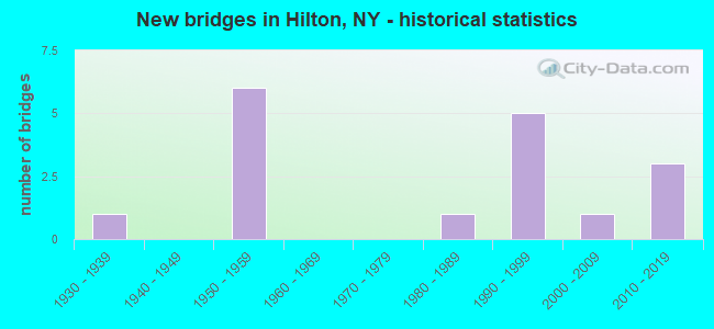
- New bridges - historical statistics
- 11930-1939
- 61950-1959
- 11980-1989
- 51990-1999
- 12000-2009
- 32010-2019

- Reconstructed bridges - Historical Statistics
- 11990-1999
- 02000-2009
- 12010-2019


- Bridge Condition - Deck
- 40.0%Very good
- 50.0%Good
- 10.0%Satisfactory

- Bridge Condition - Superstructure
- 18.2%Excellent
- 18.2%Very good
- 27.3%Good
- 36.4%Satisfactory

- Bridge Condition - Substructure
- 36.4%Very good
- 27.3%Good
- 18.2%Satisfactory
- 18.2%Fair

- Bridge Condition - Channel
- 23.1%Very good
- 46.2%Good
- 15.4%Satisfactory
- 15.4%Fair

- Bridge Condition - Culverts
- 75.0%Very good
- 25.0%Satisfactory
Find on map >> Show street view
Structure Number: 101479, Location: 0.1 MI S JCT RTS 18 & 259 (Lat: 43.286381, Lng: -77.791514), Route carried "on" structure: State highway 18, Year Built: 1930, Year Reconstructed: 1995, Status: Open, Structure Length: 2.65m (8.69ft), Average Daily Traffic: 5,510 (year 2020), Truck Traffic: 4%, Average Future Daily Traffic: 6,693 (year 2040), Design Load: HS 25 or greater, Features Intersected: SALMON CREEK
Minimum Vertical Clearance: 30+ m (98+ ft), Kilometerpoint: 17.619, Lanes on structure: 2, Base Highway Network: Yes, Owner: State Highway Agency, Approaching Roadway Width: 13.7m (44.9ft), Material/Design: Prestressed concrete, Design/Construction: Box Beam or Girders - Multiple, Number Of Spans In Main Unit: 1, Length of Maximum Span: 25.9m (85.0ft), Curb or Sidewalk Widths: Left: 1.5m (4.9ft), Right: 1.5m (4.9ft), Curb-To-Curb Width: 10.6m (34.8ft), Out-to-Out Width: 14.3m (46.9ft)
Condition: Deck: Very good, Superstructure: Good, Substructure: Good, Channel: Good, Operating Rating: 66.2 metric tons, Method Used To Determine Operating Rating: Load Factor (LF), Inventory Rating: 39.9 metric tons, Method Used To Determine Inventory Rating: Load Factor (LF), Structural Evaluation: Better than present minimum criteria, Deck Geometry: Meets minimum limits, Waterway Adequacy: Equal to present minimum criteria, Approach Roadway Alignment: Equal to present minimum criteria, Length Of Structure Improvement: 2.65m (8.69ft), Designated Inspection Frequency: Every 24 months, Inspection Date: October 2021, Bridge Improvement Cost: $1,098,000, Roadway Improvement Cost: $643,000, Total Project Cost: $1,741,000 ( Estimate for 2021), Deck Structure Type: Concrete Cast-file-Place, Wearing Surface/Protective System: Wearing Surface: Bituminous, Membrane: Preformed Fabric, Deck Protection: Epoxy Coated Reinforcing
Find on map >> Show street view
Structure Number: 1035901, Location: 2 mi e LOSP & SH 261 (Lat: 43.315050, Lng: -77.727764), Route carried "on" structure: State highway 947, Year Built: 2014, Status: Open, Structure Length: 7.68m (25.20ft), Average Daily Traffic: 3,917 (year 2020), Truck Traffic: 1%, Average Future Daily Traffic: 4,086 (year 2040), Design Load: HL 93, Features Intersected: SALMON CREEK
Minimum Vertical Clearance: 30+ m (98+ ft), Kilometerpoint: 23.572, Lanes on structure: 2, Owner: State Highway Agency, Approaching Roadway Width: 9.1m (29.9ft), Skew: 1 degrees, Material/Design: Steel continuous, Design/Construction: Stringer/Multi-beam, Number Of Spans In Main Unit: 3, Length of Maximum Span: 30.8m (101.0ft), Curb-To-Curb Width: 10.4m (34.1ft), Out-to-Out Width: 11.5m (37.7ft)
Condition: Deck: Very good, Superstructure: Excellent, Substructure: Very good, Channel: Very good, Inventory Rating: 60.8 metric tons, Method Used To Determine Inventory Rating: Load Factor (LF), Structural Evaluation: Equal to present desirable criteria, Deck Geometry: Meets minimum limits, Waterway Adequacy: Equal to present minimum criteria, Approach Roadway Alignment: Equal to present desirable criteria, Length Of Structure Improvement: 7.68m (25.20ft), Designated Inspection Frequency: Every 24 months, Inspection Date: September 2020, Bridge Improvement Cost: $2,002,000, Roadway Improvement Cost: $1,172,000, Total Project Cost: $3,174,000 ( Estimate for 2021), Deck Structure Type: Concrete Cast-file-Place, Wearing Surface/Protective System: Wearing Surface: Integral Concrete, Deck Protection: Epoxy Coated Reinforcing
Find on map >> Show street view
Structure Number: 1035902, Location: .2 mi E Jct LOSP & SH 261 (Lat: 43.315228, Lng: -77.727942), Route carried "on" structure: State highway 947, Year Built: 2013, Status: Open, Structure Length: 7.68m (25.20ft), Average Daily Traffic: 3,917 (year 2020), Truck Traffic: 1%, Average Future Daily Traffic: 4,086 (year 2040), Design Load: HL 93, Features Intersected: Salmon Creek
Minimum Vertical Clearance: 30+ m (98+ ft), Kilometerpoint: 23.572, Lanes on structure: 2, Owner: State Highway Agency, Approaching Roadway Width: 9.1m (29.9ft), Skew: 1 degrees, Material/Design: Steel continuous, Design/Construction: Stringer/Multi-beam, Number Of Spans In Main Unit: 3, Length of Maximum Span: 30.8m (101.0ft), Curb-To-Curb Width: 10.4m (34.1ft), Out-to-Out Width: 11.5m (37.7ft)
Condition: Deck: Good, Superstructure: Excellent, Substructure: Very good, Channel: Very good, Inventory Rating: 60.8 metric tons, Method Used To Determine Inventory Rating: Load Factor (LF), Structural Evaluation: Equal to present desirable criteria, Deck Geometry: Meets minimum limits, Waterway Adequacy: Equal to present minimum criteria, Approach Roadway Alignment: Equal to present desirable criteria, Length Of Structure Improvement: 7.68m (25.20ft), Designated Inspection Frequency: Every 24 months, Inspection Date: September 2020, Bridge Improvement Cost: $2,002,000, Roadway Improvement Cost: $1,172,000, Total Project Cost: $3,174,000 ( Estimate for 2021), Deck Structure Type: Concrete Cast-file-Place, Wearing Surface/Protective System: Wearing Surface: Integral Concrete, Deck Protection: Epoxy Coated Reinforcing
Find on map >> Show street view
Structure Number: 1035919, Location: 1.2MI E JCT LOSP+RTE261 (Lat: 43.302111, Lng: -77.722528), Route carried "on" structure: State highway 947A, Year Built: 1954, Status: Open, Structure Length: 1.07m (3.51ft), Average Daily Traffic: 7,834 (year 2020), Truck Traffic: 1%, Average Future Daily Traffic: 8,171 (year 2040), Design Load: H 20, Features Intersected: BUTTONWOOD CREEK
Minimum Vertical Clearance: 30+ m (98+ ft), Kilometerpoint: 25.133, Lanes on structure: 4, Base Highway Network: Yes, Owner: State Highway Agency, Approaching Roadway Width: 20.1m (65.9ft), Skew: 23 degrees, Material/Design: Concrete, Design/Construction: Culvert, Number Of Spans In Main Unit: 1, Length of Maximum Span: 9.4m (30.8ft), Curb or Sidewalk Widths: Left: 1.9m (6.2ft), Right: 1.9m (6.2ft), Curb-To-Curb Width: 17.1m (56.1ft), Out-to-Out Width: 24.6m (80.7ft)
Condition: Channel: Good, Culverts: Satisfactory, Operating Rating: 49.2 metric tons, Method Used To Determine Operating Rating: Load and Resistance Factor Rating (LRFR) rating reported by rating factor(RF) method using HL-93 loadings, Inventory Rating: 38.2 metric tons, Method Used To Determine Inventory Rating: Load and Resistance Factor Rating (LRFR) rating reported by rating factor(RF) method using HL-93 loadings, Structural Evaluation: Equal to present minimum criteria, Deck Geometry: High priority of corrective action, Waterway Adequacy: Equal to present minimum criteria, Approach Roadway Alignment: Better than present minimum criteria, Length Of Structure Improvement: 1.06m (3.48ft), Designated Inspection Frequency: Every 24 months, Underwater Inspection Frequency: Every 60 months, Inspection Date: September 2021, Underwater Inspection Date: August 2017, Bridge Improvement Cost: $1,388,000, Roadway Improvement Cost: $813,000, Total Project Cost: $2,201,000 ( Estimate for 2021)
Find on map >> Show street view
Structure Number: 103592, Location: 1.6MI E JCT LOSP+RTE261 (Lat: 43.297183, Lng: -77.719153), Route carried "on" structure: County highway , Year Built: 1955, Status: Open, Structure Length: 4.45m (14.60ft), Average Daily Traffic: 2,913 (year 2020), Truck Traffic: 3%, Average Future Daily Traffic: 3,604 (year 2040), Design Load: H 20, Features Intersected: 947A947A43021160 WB, RTE, Facility Carried by Structure: EAST MANITOU ROAD
Minimum Vertical Clearance: 30+ m (98+ ft), Kilometerpoint: 1.158, Lanes on structure: 2, Lanes under structure: 6, Owner: State Highway Agency, Approaching Roadway Width: 9.8m (32.2ft), Skew: 1 degrees, Material/Design: Concrete, Design/Construction: Arch - Deck, Number Of Spans In Main Unit: 2, Length of Maximum Span: 16.4m (53.8ft), Curb or Sidewalk Widths: Left: 0.8m (2.6ft), Right: 0.8m (2.6ft), Curb-To-Curb Width: 11.0m (36.1ft), Out-to-Out Width: 13.3m (43.6ft)
Condition: Superstructure: Satisfactory, Substructure: Good, Operating Rating: 56.1 metric tons, Method Used To Determine Operating Rating: Field evaluation and documented engineering judgment, Inventory Rating: 22.6 metric tons, Method Used To Determine Inventory Rating: Field evaluation and documented engineering judgment, Structural Evaluation: Equal to present minimum criteria, Deck Geometry: Somewhat better than minimum adequacy, Underclear: High priority of corrective action, Approach Roadway Alignment: Equal to present desirable criteria, Length Of Structure Improvement: 4.45m (14.60ft), Designated Inspection Frequency: Every 24 months, Inspection Date: May 2021, Bridge Improvement Cost: $4,135,000, Roadway Improvement Cost: $2,421,000, Total Project Cost: $6,556,000 ( Estimate for 2021), Wearing Surface/Protective System: Wearing Surface: Bituminous
Find on map >> Show street view
Structure Number: 104366, Location: 1.0 MI N JCT RTS 261 & 18 (Lat: 43.273750, Lng: -77.750258), Route carried "on" structure: State highway 261, Year Built: 1993, Status: Open, Structure Length: 1.04m (3.41ft), Average Daily Traffic: 5,985 (year 2020), Truck Traffic: 5%, Average Future Daily Traffic: 7,270 (year 2040), Design Load: HS 25 or greater, Features Intersected: BLACK CREEK
Minimum Vertical Clearance: 30+ m (98+ ft), Kilometerpoint: 6.259, Lanes on structure: 2, Base Highway Network: Yes, Owner: State Highway Agency, Approaching Roadway Width: 11.6m (38.1ft), Material/Design: Concrete, Design/Construction: Frame, Number Of Spans In Main Unit: 1, Length of Maximum Span: 10.0m (32.8ft), Curb or Sidewalk Widths: Left: 0.0m, Right: 2.1m (6.9ft), Curb-To-Curb Width: 11.6m (38.1ft), Out-to-Out Width: 14.3m (46.9ft)
Condition: Deck: Very good, Superstructure: Very good, Substructure: Very good, Channel: Satisfactory, Operating Rating: 79.7 metric tons, Method Used To Determine Operating Rating: Field evaluation and documented engineering judgment, Inventory Rating: 40.8 metric tons, Method Used To Determine Inventory Rating: Field evaluation and documented engineering judgment, Structural Evaluation: Equal to present desirable criteria, Deck Geometry: Somewhat better than minimum adequacy, Waterway Adequacy: Equal to present desirable criteria, Approach Roadway Alignment: Equal to present desirable criteria, Length Of Structure Improvement: 1.03m (3.38ft), Designated Inspection Frequency: Every 24 months, Inspection Date: August 2021, Bridge Improvement Cost: $423,000, Roadway Improvement Cost: $248,000, Total Project Cost: $670,000 ( Estimate for 2021)
Find on map >> Show street view
Structure Number: 104367, Location: 1.9 MI N JCT RT 261 & 18 (Lat: 43.286686, Lng: -77.749656), Route carried "on" structure: State highway 261, Year Built: 1993, Status: Open, Structure Length: 0.98m (3.22ft), Average Daily Traffic: 5,985 (year 2020), Truck Traffic: 5%, Average Future Daily Traffic: 7,270 (year 2040), Design Load: HS 25 or greater, Features Intersected: BUTTONWOOD CREEK
Minimum Vertical Clearance: 30+ m (98+ ft), Kilometerpoint: 7.691, Lanes on structure: 2, Base Highway Network: Yes, Owner: State Highway Agency, Approaching Roadway Width: 11.6m (38.1ft), Skew: 1 degrees, Material/Design: Concrete, Design/Construction: Frame, Number Of Spans In Main Unit: 1, Length of Maximum Span: 9.1m (29.9ft), Curb or Sidewalk Widths: Left: 0.0m, Right: 2.1m (6.9ft), Curb-To-Curb Width: 11.6m (38.1ft), Out-to-Out Width: 17.7m (58.1ft)
Condition: Deck: Good, Superstructure: Good, Substructure: Very good, Channel: Satisfactory, Operating Rating: 79.1 metric tons, Method Used To Determine Operating Rating: Field evaluation and documented engineering judgment, Inventory Rating: 40.8 metric tons, Method Used To Determine Inventory Rating: Field evaluation and documented engineering judgment, Structural Evaluation: Better than present minimum criteria, Deck Geometry: Somewhat better than minimum adequacy, Waterway Adequacy: Equal to present minimum criteria, Approach Roadway Alignment: Equal to present desirable criteria, Length Of Structure Improvement: 0.97m (3.18ft), Designated Inspection Frequency: Every 24 months, Inspection Date: July 2021, Bridge Improvement Cost: $415,000, Roadway Improvement Cost: $243,000, Total Project Cost: $658,000 ( Estimate for 2021)
Find on map >> Show street view
Structure Number: 104369, Location: 1.8 MI S JCT 261 & LOSP (Lat: 43.305717, Lng: -77.748739), Route carried "on" structure: State highway 261, Year Built: 1983, Status: Open, Structure Length: 1.74m (5.71ft), Average Daily Traffic: 2,757 (year 2020), Truck Traffic: 6%, Average Future Daily Traffic: 3,349 (year 2040), Design Load: HS 20, Features Intersected: WEST CREEK
Minimum Vertical Clearance: 30+ m (98+ ft), Kilometerpoint: 9.815, Lanes on structure: 2, Base Highway Network: Yes, Owner: State Highway Agency, Approaching Roadway Width: 12.2m (40.0ft), Material/Design: Prestressed concrete, Design/Construction: Box Beam or Girders - Multiple, Number Of Spans In Main Unit: 1, Length of Maximum Span: 16.1m (52.8ft), Curb-To-Curb Width: 12.5m (41.0ft), Out-to-Out Width: 13.2m (43.3ft)
Condition: Deck: Good, Superstructure: Satisfactory, Substructure: Fair, Channel: Good, Operating Rating: 82.6 metric tons, Method Used To Determine Operating Rating: Load Factor (LF), Inventory Rating: 24.5 metric tons, Method Used To Determine Inventory Rating: Load Factor (LF), Structural Evaluation: Somewhat better than minimum adequacy, Deck Geometry: Equal to present minimum criteria, Waterway Adequacy: Equal to present minimum criteria, Approach Roadway Alignment: Equal to present desirable criteria, Length Of Structure Improvement: 1.73m (5.68ft), Designated Inspection Frequency: Every 24 months, Underwater Inspection Frequency: Every 60 months, Inspection Date: August 2020, Underwater Inspection Date: August 2017, Bridge Improvement Cost: $971,000, Roadway Improvement Cost: $569,000, Total Project Cost: $1,540,000 ( Estimate for 2021), Deck Structure Type: Concrete Cast-file-Place, Wearing Surface/Protective System: Wearing Surface: Bituminous, Membrane: Other
Find on map >> Show street view
Structure Number: 10437, Location: JCT RTE 261 + LOSP (Lat: 43.318064, Lng: -77.728367), Route carried "on" structure: State highway 261, Year Built: 1954, Status: Open, Structure Length: 3.05m (10.01ft), Average Daily Traffic: 2,757 (year 2020), Truck Traffic: 9%, Average Future Daily Traffic: 3,349 (year 2040), Design Load: H 20, Features Intersected: 947A947A43021145WB, RTE
Minimum Vertical Clearance: 30+ m (98+ ft), Kilometerpoint: 12.325, Lanes on structure: 2, Lanes under structure: 6, Base Highway Network: Yes, Owner: State Highway Agency, Approaching Roadway Width: 7.3m (24.0ft), Skew: 1 degrees, Material/Design: Concrete, Design/Construction: Frame, Number Of Spans In Main Unit: 1, Length of Maximum Span: 28.0m (91.9ft), Curb or Sidewalk Widths: Left: 0.8m (2.6ft), Right: 0.8m (2.6ft), Curb-To-Curb Width: 11.0m (36.1ft), Out-to-Out Width: 13.3m (43.6ft)
Condition: Deck: Satisfactory, Superstructure: Satisfactory, Substructure: Fair, Operating Rating: 69.7 metric tons, Method Used To Determine Operating Rating: Field evaluation and documented engineering judgment, Inventory Rating: 25.8 metric tons, Method Used To Determine Inventory Rating: Field evaluation and documented engineering judgment, Structural Evaluation: Somewhat better than minimum adequacy, Deck Geometry: Somewhat better than minimum adequacy, Underclear: High priority of corrective action, Approach Roadway Alignment: Equal to present desirable criteria, Length Of Structure Improvement: 3.04m (9.97ft), Designated Inspection Frequency: Every 24 months, Inspection Date: April 2020, Bridge Improvement Cost: $1,339,000, Roadway Improvement Cost: $784,000, Total Project Cost: $2,123,000 ( Estimate for 2021), Wearing Surface/Protective System: Wearing Surface: Bituminous
Find on map >> Show street view
Structure Number: 331705, Location: 2 MI N OF N GREECE (Lat: 43.281075, Lng: -77.731928), Route carried "on" structure: County highway , Year Built: 1990, Status: Open, Structure Length: 1.34m (4.40ft), Average Daily Traffic: 2,249 (year 2020), Truck Traffic: 3%, Average Future Daily Traffic: 2,782 (year 2040), Design Load: HS 20, Features Intersected: NORTHRUP CREEK, Facility Carried by Structure: NORTH GREECE ROAD
Minimum Vertical Clearance: 30+ m (98+ ft), Kilometerpoint: 7.450, Lanes on structure: 2, Owner: County Highway Agency, Approaching Roadway Width: 11.6m (38.1ft), Skew: 1 degrees, Material/Design: Prestressed concrete, Design/Construction: Box Beam or Girders - Multiple, Number Of Spans In Main Unit: 1, Length of Maximum Span: 12.8m (42.0ft), Curb or Sidewalk Widths: Left: 0.3m (1.0ft), Right: 2.1m (6.9ft), Curb-To-Curb Width: 11.7m (38.4ft), Out-to-Out Width: 14.8m (48.6ft)
Condition: Deck: Good, Superstructure: Good, Substructure: Good, Channel: Fair, Operating Rating: 81.6 metric tons, Method Used To Determine Operating Rating: Field evaluation and documented engineering judgment, Inventory Rating: 32.7 metric tons, Method Used To Determine Inventory Rating: Field evaluation and documented engineering judgment, Structural Evaluation: Better than present minimum criteria, Deck Geometry: Somewhat better than minimum adequacy, Waterway Adequacy: Equal to present minimum criteria, Approach Roadway Alignment: Better than present minimum criteria, Length Of Structure Improvement: 1.34m (4.40ft), Designated Inspection Frequency: Every 24 months, Inspection Date: April 2021, Bridge Improvement Cost: $672,000, Roadway Improvement Cost: $394,000, Total Project Cost: $1,065,000 ( Estimate for 2021), Wearing Surface/Protective System: Wearing Surface: Bituminous, Membrane: Other
Find on map >> Show street view
Structure Number: 331706, Location: 4 MI N OF N GREECE (Lat: 43.296286, Lng: -77.731544), Route carried "on" structure: County highway , Year Built: 1995, Status: Open, Structure Length: 1.16m (3.81ft), Average Daily Traffic: 722 (year 2019), Truck Traffic: 4%, Average Future Daily Traffic: 1,011 (year 2039), Design Load: HS 25 or greater, Features Intersected: BUTTONWOOD CREEK, Facility Carried by Structure: NORTH GREECE ROAD
Minimum Vertical Clearance: 30+ m (98+ ft), Kilometerpoint: 9.139, Lanes on structure: 2, Owner: County Highway Agency, Approaching Roadway Width: 10.4m (34.1ft), Material/Design: Prestressed concrete, Design/Construction: Box Beam or Girders - Multiple, Number Of Spans In Main Unit: 1, Length of Maximum Span: 11.2m (36.7ft), Curb-To-Curb Width: 10.4m (34.1ft), Out-to-Out Width: 11.1m (36.4ft)
Condition: Deck: Very good, Superstructure: Very good, Substructure: Satisfactory, Channel: Very good, Operating Rating: 73.5 metric tons, Method Used To Determine Operating Rating: Load and Resistance Factor Rating (LRFR) rating reported by rating factor(RF) method using HL-93 loadings, Inventory Rating: 56.7 metric tons, Method Used To Determine Inventory Rating: Load and Resistance Factor Rating (LRFR) rating reported by rating factor(RF) method using HL-93 loadings, Structural Evaluation: Equal to present minimum criteria, Deck Geometry: Equal to present minimum criteria, Waterway Adequacy: Meets minimum limits, Approach Roadway Alignment: Equal to present minimum criteria, Length Of Structure Improvement: 1.15m (3.77ft), Designated Inspection Frequency: Every 24 months, Underwater Inspection Frequency: Every 60 months, Inspection Date: August 2020, Underwater Inspection Date: July 2019, Bridge Improvement Cost: $584,000, Roadway Improvement Cost: $342,000, Total Project Cost: $926,000 ( Estimate for 2021), Wearing Surface/Protective System: Wearing Surface: Bituminous, Membrane: Other
Find on map >> Show street view
Structure Number: 331707, Location: 2.3 MI N OF GREECE (Lat: 43.288083, Lng: -77.744856), Route carried "on" structure: County highway , Year Built: 1994, Status: Open, Structure Length: 0.64m (2.10ft), Average Daily Traffic: 3,832 (year 2020), Truck Traffic: 3%, Average Future Daily Traffic: 4,741 (year 2040), Design Load: HS 25 or greater, Features Intersected: BUTTONWOOD CREEK, Facility Carried by Structure: FRISBEE HILL ROAD
Minimum Vertical Clearance: 30+ m (98+ ft), Kilometerpoint: 0.386, Lanes on structure: 2, Owner: County Highway Agency, Approaching Roadway Width: 10.4m (34.1ft), Material/Design: Concrete, Design/Construction: Culvert, Number Of Spans In Main Unit: 1, Length of Maximum Span: 6.1m (20.0ft), Curb-To-Curb Width: 10.2m (33.5ft), Out-to-Out Width: 11.0m (36.1ft)
Condition: Channel: Good, Culverts: Very good, Operating Rating: 76.9 metric tons, Method Used To Determine Operating Rating: Field evaluation and documented engineering judgment, Inventory Rating: 40.8 metric tons, Method Used To Determine Inventory Rating: Field evaluation and documented engineering judgment, Structural Evaluation: Equal to present desirable criteria, Deck Geometry: Meets minimum limits, Waterway Adequacy: Equal to present minimum criteria, Approach Roadway Alignment: Equal to present desirable criteria, Length Of Structure Improvement: 0.64m (2.10ft), Designated Inspection Frequency: Every 24 months, Inspection Date: May 2021, Bridge Improvement Cost: $127,000, Roadway Improvement Cost: $74,000, Total Project Cost: $201,000 ( Estimate for 2021)
Find on map >> Show street view
Structure Number: 331751, Location: 1.25 MI N OF N GREECE (Lat: 43.271903, Lng: -77.732175), Route carried "on" structure: County highway , Year Built: 2006, Status: Open, Structure Length: 1.28m (4.20ft), Average Daily Traffic: 2,767 (year 2020), Truck Traffic: 5%, Average Future Daily Traffic: 3,423 (year 2040), Design Load: HS 25 or greater, Features Intersected: NORTHRUP CREEK, Facility Carried by Structure: NORTH GREECE ROAD
Minimum Vertical Clearance: 30+ m (98+ ft), Kilometerpoint: 6.436, Lanes on structure: 2, Owner: County Highway Agency, Approaching Roadway Width: 11.9m (39.0ft), Skew: 2 degrees, Material/Design: Concrete, Design/Construction: Culvert, Number Of Spans In Main Unit: 1, Length of Maximum Span: 12.2m (40.0ft), Curb or Sidewalk Widths: Left: 0.0m, Right: 1.7m (5.6ft), Curb-To-Curb Width: 10.2m (33.5ft), Out-to-Out Width: 15.6m (51.2ft)
Condition: Channel: Good, Culverts: Very good, Operating Rating: 81.3 metric tons, Method Used To Determine Operating Rating: Field evaluation and documented engineering judgment, Inventory Rating: 40.8 metric tons, Method Used To Determine Inventory Rating: Field evaluation and documented engineering judgment, Structural Evaluation: Equal to present desirable criteria, Deck Geometry: Meets minimum limits, Waterway Adequacy: Somewhat better than minimum adequacy, Approach Roadway Alignment: Equal to present desirable criteria, Length Of Structure Improvement: 1.28m (4.20ft), Designated Inspection Frequency: Every 24 months, Inspection Date: October 2020, Bridge Improvement Cost: $470,000, Roadway Improvement Cost: $275,000, Total Project Cost: $745,000 ( Estimate for 2021)
Find on map >> Show street view
Structure Number: 331752, Location: 1.6 MI N OF NORTH GREECE (Lat: 43.276161, Lng: -77.732053), Route carried "on" structure: County highway , Year Built: 1956, Year Reconstructed: 2015, Status: Open, Structure Length: 1.01m (3.31ft), Average Daily Traffic: 2,249 (year 2020), Truck Traffic: 3%, Average Future Daily Traffic: 2,782 (year 2040), Design Load: HS 20, Features Intersected: NORTHRUP CREEK, Facility Carried by Structure: NORTH GREECE ROAD
Minimum Vertical Clearance: 30+ m (98+ ft), Kilometerpoint: 6.903, Lanes on structure: 2, Owner: County Highway Agency, Approaching Roadway Width: 6.7m (22.0ft), Skew: 3 degrees, Material/Design: Steel, Design/Construction: Stringer/Multi-beam, Number Of Spans In Main Unit: 1, Length of Maximum Span: 9.7m (31.8ft), Curb-To-Curb Width: 9.1m (29.9ft), Out-to-Out Width: 10.1m (33.1ft)
Condition: Deck: Good, Superstructure: Satisfactory, Substructure: Satisfactory, Channel: Fair, Operating Rating: 62.6 metric tons, Method Used To Determine Operating Rating: Load Factor (LF), Inventory Rating: 37.2 metric tons, Method Used To Determine Inventory Rating: Load Factor (LF), Structural Evaluation: Equal to present minimum criteria, Deck Geometry: Meets minimum limits, Waterway Adequacy: Equal to present desirable criteria, Approach Roadway Alignment: Equal to present minimum criteria, Length Of Structure Improvement: 1.00m (3.28ft), Designated Inspection Frequency: Every 24 months, Inspection Date: April 2020, Bridge Improvement Cost: $363,000, Roadway Improvement Cost: $213,000, Total Project Cost: $576,000 ( Estimate for 2021), Deck Structure Type: Concrete Precast Panels, Wearing Surface/Protective System: Wearing Surface: Bituminous
Find on map >> Show street view
Structure Number: 331753, Location: 1.8 MI.N OF N.GREECE (Lat: 43.279817, Lng: -77.731958), Route carried "on" structure: County highway , Year Built: 2010, Status: Open, Structure Length: 1.28m (4.20ft), Average Daily Traffic: 2,249 (year 2020), Truck Traffic: 3%, Average Future Daily Traffic: 2,782 (year 2040), Design Load: HL 93, Features Intersected: NORTHRUP CREEK, Facility Carried by Structure: NORTH GREECE ROAD
Minimum Vertical Clearance: 30+ m (98+ ft), Kilometerpoint: 7.321, Lanes on structure: 2, Owner: County Highway Agency, Approaching Roadway Width: 10.4m (34.1ft), Skew: 4 degrees, Material/Design: Concrete, Design/Construction: Culvert, Number Of Spans In Main Unit: 1, Length of Maximum Span: 12.2m (40.0ft), Curb or Sidewalk Widths: Left: 0.0m, Right: 1.5m (4.9ft)
Condition: Channel: Good, Culverts: Very good, Operating Rating: 81.3 metric tons, Method Used To Determine Operating Rating: Field evaluation and documented engineering judgment, Inventory Rating: 40.8 metric tons, Method Used To Determine Inventory Rating: Field evaluation and documented engineering judgment, Structural Evaluation: Equal to present desirable criteria, Waterway Adequacy: Somewhat better than minimum adequacy, Approach Roadway Alignment: Equal to present desirable criteria, Length Of Structure Improvement: 1.28m (4.20ft), Designated Inspection Frequency: Every 24 months, Inspection Date: October 2020, Bridge Improvement Cost: $415,000, Roadway Improvement Cost: $243,000, Total Project Cost: $659,000 ( Estimate for 2021)
Find on map >> Show street view
Structure Number: 103592, Location: 1.6MI E JCT LOSP+RTE261 (Lat: 43.297183, Lng: -77.719153), Route carried "under" structure: State highway 947A, Year Built: 1955, Structure Length: 0. m, Average Daily Traffic: 8,224 (year 2011), Features Intersected: 947A947A43021160 WB, RTE, Facility Carried by Structure: EAST MANITOU ROAD
Minimum Vertical Clearance: 4.90m (16.08ft), Kilometerpoint: 45.857, Lanes on structure: 2, Lanes under structure: 3, Material/Design: Concrete, Design/Construction: Arch - Deck, Length of Maximum Span: 16.4m (53.8ft)
Find on map >> Show street view
Structure Number: 10437, Location: JCT RTE 261 + LOSP (Lat: 43.318064, Lng: -77.728367), Route carried "under" structure: County highway 947A, Year Built: 1954, Structure Length: 0. m, Average Daily Traffic: 14,069 (year 2002), Features Intersected: 947A947A43021145WB, RTE, Facility Carried by Structure: RTE 261
Minimum Vertical Clearance: 4.83m (15.85ft), Kilometerpoint: 27.353, Lanes on structure: 2, Lanes under structure: 3, Material/Design: Concrete, Design/Construction: Frame, Length of Maximum Span: 28.0m (91.9ft)