Bridge Statistics for Hinsdale, New York (NY)
Condition, Traffic, Stress, Structural Evaluation, Project Costs
- National Bridge Inventory (NBI) Statistics
- 38Number of bridges
- 322ft / 98.1mTotal length
- $86,753,000Total costs
- 120,844Total average daily traffic
- 15,171Total average daily truck traffic
- National Bridge Inventory (NBI) Registered Bridges for Hinsdale
- No street view available for this location
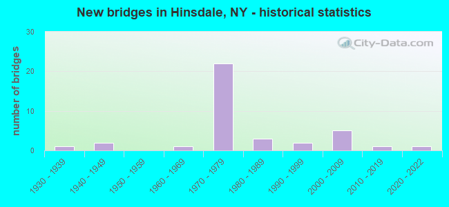
- New bridges - historical statistics
- 11930-1939
- 21940-1949
- 11960-1969
- 221970-1979
- 31980-1989
- 21990-1999
- 52000-2009
- 12010-2019
- 12020-2022

- Reconstructed bridges - Historical Statistics
- 21980-1989
- 01990-1999
- 42000-2009


- Bridge Condition - Deck
- 16.0%Excellent
- 24.0%Very good
- 36.0%Good
- 20.0%Satisfactory
- 4.0%Fair

- Bridge Condition - Superstructure
- 20.0%Excellent
- 40.0%Very good
- 28.0%Good
- 4.0%Satisfactory
- 8.0%Poor

- Bridge Condition - Substructure
- 8.0%Excellent
- 44.0%Very good
- 32.0%Good
- 8.0%Satisfactory
- 8.0%Fair

- Bridge Condition - Channel
- 4.8%Excellent
- 33.3%Very good
- 28.6%Good
- 28.6%Satisfactory
- 4.8%Fair

- Bridge Condition - Culverts
- 75.0%Very good
- 25.0%Fair
Find on map >> Show street view
Structure Number: 101168, Location: 1.8 MI S JCT RTS 16 + 17 (Lat: 42.155089, Lng: -78.397319), Route carried "on" structure: State highway 16, Year Built: 1947, Status: Open, Structure Length: 0.85m (2.79ft), Average Daily Traffic: 4,501 (year 2019), Truck Traffic: 6%, Average Future Daily Traffic: 5,569 (year 2040), Features Intersected: SCOTT BRANCH CRK
Minimum Vertical Clearance: 30+ m (98+ ft), Kilometerpoint: 23.395, Lanes on structure: 4, Base Highway Network: Yes, Owner: State Highway Agency, Approaching Roadway Width: 20.4m (66.9ft), Skew: 6 degrees, Material/Design: Concrete, Design/Construction: Culvert, Number Of Spans In Main Unit: 1, Length of Maximum Span: 7.9m (25.9ft), Curb-To-Curb Width: 20.5m (67.3ft), Out-to-Out Width: 21.1m (69.2ft)
Condition: Channel: Good, Culverts: Fair, Operating Rating: 70.5 metric tons, Method Used To Determine Operating Rating: Field evaluation and documented engineering judgment, Inventory Rating: 30.6 metric tons, Method Used To Determine Inventory Rating: Field evaluation and documented engineering judgment, Structural Evaluation: Somewhat better than minimum adequacy, Deck Geometry: Superior to present desirable criteria, Waterway Adequacy: Meets minimum limits, Approach Roadway Alignment: Equal to present desirable criteria, Length Of Structure Improvement: 0.85m (2.79ft), Designated Inspection Frequency: Every 24 months, Inspection Date: June 2020, Bridge Improvement Cost: $497,000, Roadway Improvement Cost: $291,000, Total Project Cost: $788,000 ( Estimate for 2021), Wearing Surface/Protective System: Wearing Surface: Bituminous
Find on map >> Show street view
Structure Number: 101169, Location: 0.5 MI S JCT RTS 16 & 17 (Lat: 42.169903, Lng: -78.387767), Route carried "on" structure: State highway 16, Year Built: 1947, Year Reconstructed: 1993, Status: Open, Structure Length: 3.47m (11.38ft), Average Daily Traffic: 4,501 (year 2019), Truck Traffic: 6%, Average Future Daily Traffic: 5,569 (year 2040), Design Load: HS 20, Features Intersected: OIL CREEK
Minimum Vertical Clearance: 30+ m (98+ ft), Kilometerpoint: 25.326, Lanes on structure: 4, Base Highway Network: Yes, Owner: State Highway Agency, Approaching Roadway Width: 18.3m (60.0ft), Skew: 1 degrees, Material/Design: Steel, Design/Construction: Stringer/Multi-beam, Number Of Spans In Main Unit: 2, Length of Maximum Span: 16.7m (54.8ft), Curb-To-Curb Width: 18.3m (60.0ft), Out-to-Out Width: 18.9m (62.0ft)
Condition: Deck: Satisfactory, Superstructure: Satisfactory, Substructure: Satisfactory, Channel: Satisfactory, Operating Rating: 57.7 metric tons, Method Used To Determine Operating Rating: Load and Resistance Factor Rating (LRFR) rating reported by rating factor(RF) method using HL-93 loadings, Inventory Rating: 44.4 metric tons, Method Used To Determine Inventory Rating: Load and Resistance Factor Rating (LRFR) rating reported by rating factor(RF) method using HL-93 loadings, Structural Evaluation: Equal to present minimum criteria, Deck Geometry: Somewhat better than minimum adequacy, Waterway Adequacy: Meets minimum limits, Approach Roadway Alignment: Equal to present desirable criteria, Length Of Structure Improvement: 3.47m (11.38ft), Designated Inspection Frequency: Every 24 months, Inspection Date: November 2020, Bridge Improvement Cost: $3,072,000, Roadway Improvement Cost: $1,799,000, Total Project Cost: $4,871,000 ( Estimate for 2021), Deck Structure Type: Concrete Cast-file-Place, Wearing Surface/Protective System: Wearing Surface: Integral Concrete, Deck Protection: Epoxy Coated Reinforcing
Find on map >> Show street view
Structure Number: 104774, Location: 0.9 MI E JCT RTS 119+22 (Lat: 42.215814, Lng: -78.326964), Route carried "on" structure: State highway 446, Year Built: 1969, Status: Open, Structure Length: 0.73m (2.40ft), Average Daily Traffic: 1,622 (year 2019), Truck Traffic: 7%, Average Future Daily Traffic: 1,638 (year 2040), Design Load: HS 20, Features Intersected: PAINTERLICK CRK
Minimum Vertical Clearance: 30+ m (98+ ft), Kilometerpoint: 6.565, Lanes on structure: 2, Base Highway Network: Yes, Owner: State Highway Agency, Approaching Roadway Width: 11.3m (37.1ft), Material/Design: Concrete, Design/Construction: Culvert, Number Of Spans In Main Unit: 1, Length of Maximum Span: 6.7m (22.0ft), Curb-To-Curb Width: 13.1m (43.0ft), Out-to-Out Width: 14.0m (45.9ft)
Condition: Channel: Very good, Culverts: Very good, Operating Rating: 77.3 metric tons, Method Used To Determine Operating Rating: Field evaluation and documented engineering judgment, Inventory Rating: 32.7 metric tons, Method Used To Determine Inventory Rating: Field evaluation and documented engineering judgment, Structural Evaluation: Equal to present desirable criteria, Deck Geometry: Better than present minimum criteria, Waterway Adequacy: Equal to present minimum criteria, Approach Roadway Alignment: Equal to present minimum criteria, Length Of Structure Improvement: 0.73m (2.40ft), Designated Inspection Frequency: Every 24 months, Inspection Date: June 2020, Bridge Improvement Cost: $284,000, Roadway Improvement Cost: $166,000, Total Project Cost: $450,000 ( Estimate for 2021), Deck Structure Type: Concrete Cast-file-Place, Wearing Surface/Protective System: Wearing Surface: Epoxy Overlay
Find on map >> Show street view
Structure Number: 1078711, Location: Cattaraugus County (Lat: 42.166822, Lng: -78.397014), Route carried "on" structure: Interstate 86, Year Built: 2007, Status: Open, Structure Length: 1.01m (3.31ft), Average Daily Traffic: 5,279 (year 2014), Truck Traffic: 19%, Design Load: HS 25 or greater, Features Intersected: Gull Brook
Minimum Vertical Clearance: 30+ m (98+ ft), Kilometerpoint: 73.901, Lanes on structure: 2, Base Highway Network: Yes, Owner: State Highway Agency, Approaching Roadway Width: 13.1m (43.0ft), Skew: 1 degrees, Material/Design: Concrete, Design/Construction: Frame, Number Of Spans In Main Unit: 1, Length of Maximum Span: 9.8m (32.2ft), Curb-To-Curb Width: 13.2m (43.3ft), Out-to-Out Width: 16.2m (53.1ft)
Condition: Deck: Excellent, Superstructure: Excellent, Substructure: Good, Channel: Very good, Operating Rating: 86.2 metric tons, Method Used To Determine Operating Rating: Load Factor (LF), Inventory Rating: 51.7 metric tons, Method Used To Determine Inventory Rating: Load Factor (LF), Structural Evaluation: Better than present minimum criteria, Deck Geometry: Superior to present desirable criteria, Waterway Adequacy: Equal to present minimum criteria, Approach Roadway Alignment: Equal to present desirable criteria, Length Of Structure Improvement: 1.00m (3.28ft), Designated Inspection Frequency: Every 24 months, Inspection Date: August 2021, Bridge Improvement Cost: $1,003,000, Roadway Improvement Cost: $588,000, Total Project Cost: $1,591,000 ( Estimate for 2021), Deck Structure Type: Concrete Cast-file-Place, Wearing Surface/Protective System: Wearing Surface: Bituminous, Membrane: Other, Deck Protection: Epoxy Coated Reinforcing
Find on map >> Show street view
Structure Number: 1078712, Location: Cattaraugus County (Lat: 42.166656, Lng: -78.396556), Route carried "on" structure: Interstate 86, Year Built: 2006, Status: Open, Structure Length: 1.01m (3.31ft), Average Daily Traffic: 5,036 (year 2020), Truck Traffic: 23%, Average Future Daily Traffic: 5,643 (year 2040), Design Load: HS 25 or greater, Features Intersected: Gull Brook
Minimum Vertical Clearance: 30+ m (98+ ft), Kilometerpoint: 73.901, Lanes on structure: 2, Base Highway Network: Yes, Owner: State Highway Agency, Approaching Roadway Width: 13.1m (43.0ft), Skew: 1 degrees, Material/Design: Concrete, Design/Construction: Frame, Number Of Spans In Main Unit: 1, Length of Maximum Span: 9.8m (32.2ft), Curb-To-Curb Width: 13.2m (43.3ft), Out-to-Out Width: 16.2m (53.1ft)
Condition: Deck: Very good, Superstructure: Excellent, Substructure: Very good, Channel: Very good, Operating Rating: 71.7 metric tons, Method Used To Determine Operating Rating: Load Factor (LF), Inventory Rating: 42.6 metric tons, Method Used To Determine Inventory Rating: Load Factor (LF), Structural Evaluation: Equal to present desirable criteria, Deck Geometry: Superior to present desirable criteria, Waterway Adequacy: Equal to present minimum criteria, Approach Roadway Alignment: Equal to present desirable criteria, Length Of Structure Improvement: 1.00m (3.28ft), Designated Inspection Frequency: Every 24 months, Inspection Date: August 2021, Bridge Improvement Cost: $1,118,000, Roadway Improvement Cost: $655,000, Total Project Cost: $1,773,000 ( Estimate for 2021), Wearing Surface/Protective System: Wearing Surface: Bituminous, Membrane: Other
Find on map >> Show street view
Structure Number: 1090011, Location: 0.4 MI E JCT RTS 17 + 16 (Lat: 42.177386, Lng: -78.375861), Route carried "on" structure: Interstate 86, Year Built: 1972, Year Reconstructed: 2007, Status: Open, Structure Length: 5.67m (18.60ft), Average Daily Traffic: 4,534 (year 2014), Truck Traffic: 18%, Design Load: HS 20, Features Intersected: OIL CREEK CHANNEL
Minimum Vertical Clearance: 30+ m (98+ ft), Kilometerpoint: 76.025, Lanes on structure: 2, Base Highway Network: Yes, Owner: State Highway Agency, Approaching Roadway Width: 12.5m (41.0ft), Skew: 2 degrees, Material/Design: Prestressed concrete continuous, Design/Construction: Stringer/Multi-beam, Number Of Spans In Main Unit: 2, Length of Maximum Span: 27.4m (89.9ft), Curb-To-Curb Width: 12.5m (41.0ft), Out-to-Out Width: 13.4m (44.0ft)
Condition: Deck: Very good, Superstructure: Very good, Substructure: Very good, Channel: Very good, Operating Rating: 59.3 metric tons, Method Used To Determine Operating Rating: Load and Resistance Factor Rating (LRFR) rating reported by rating factor(RF) method using HL-93 loadings, Inventory Rating: 24.3 metric tons, Method Used To Determine Inventory Rating: Load and Resistance Factor Rating (LRFR) rating reported by rating factor(RF) method using HL-93 loadings, Structural Evaluation: Equal to present minimum criteria, Deck Geometry: Better than present minimum criteria, Waterway Adequacy: Superior to present desirable criteria, Approach Roadway Alignment: Equal to present desirable criteria, Length Of Structure Improvement: 5.66m (18.57ft), Designated Inspection Frequency: Every 24 months, Inspection Date: August 2020, Bridge Improvement Cost: $2,022,000, Roadway Improvement Cost: $1,184,000, Total Project Cost: $3,205,000 ( Estimate for 2021), Deck Structure Type: Concrete Cast-file-Place, Wearing Surface/Protective System: Wearing Surface: Integral Concrete
Find on map >> Show street view
Structure Number: 1090012, Location: .4 MI EAST JCT I86 & SH16 (Lat: 42.177033, Lng: -78.375858), Route carried "on" structure: Interstate 86, Year Built: 1972, Status: Open, Structure Length: 5.67m (18.60ft), Average Daily Traffic: 4,133 (year 2020), Truck Traffic: 19%, Average Future Daily Traffic: 4,922 (year 2040), Design Load: HS 20, Features Intersected: OIL CREEK CHANNEL
Minimum Vertical Clearance: 30+ m (98+ ft), Kilometerpoint: 76.041, Lanes on structure: 2, Base Highway Network: Yes, Owner: State Highway Agency, Approaching Roadway Width: 12.5m (41.0ft), Skew: 2 degrees, Material/Design: Prestressed concrete continuous, Design/Construction: Stringer/Multi-beam, Number Of Spans In Main Unit: 2, Length of Maximum Span: 27.4m (89.9ft), Curb-To-Curb Width: 12.5m (41.0ft), Out-to-Out Width: 13.4m (44.0ft)
Condition: Deck: Very good, Superstructure: Very good, Substructure: Very good, Channel: Very good, Operating Rating: 59.6 metric tons, Method Used To Determine Operating Rating: Load and Resistance Factor Rating (LRFR) rating reported by rating factor(RF) method using HL-93 loadings, Inventory Rating: 24.3 metric tons, Method Used To Determine Inventory Rating: Load and Resistance Factor Rating (LRFR) rating reported by rating factor(RF) method using HL-93 loadings, Structural Evaluation: Equal to present minimum criteria, Deck Geometry: Better than present minimum criteria, Waterway Adequacy: Superior to present desirable criteria, Approach Roadway Alignment: Equal to present desirable criteria, Length Of Structure Improvement: 5.66m (18.57ft), Designated Inspection Frequency: Every 24 months, Inspection Date: August 2020, Bridge Improvement Cost: $2,022,000, Roadway Improvement Cost: $1,184,000, Total Project Cost: $3,205,000 ( Estimate for 2021), Deck Structure Type: Concrete Cast-file-Place, Wearing Surface/Protective System: Wearing Surface: Integral Concrete
Find on map >> Show street view
Structure Number: 109002, Location: 0.7 MI E JCT RTS 17 + 16 (Lat: 42.178300, Lng: -78.372053), Route carried "on" structure: Other road , Year Built: 1972, Year Reconstructed: 2007, Status: Open, Structure Length: 7.80m (25.59ft), Average Daily Traffic: 175 (year 2016), Truck Traffic: 3%, Average Future Daily Traffic: 245 (year 2036), Design Load: HS 20, Features Intersected: 86I 17 51125064, RTE I86, Facility Carried by Structure: UNDERWOOD ROAD
Minimum Vertical Clearance: 30+ m (98+ ft), Kilometerpoint: 2.703, Lanes on structure: 2, Lanes under structure: 4, Owner: State Highway Agency, Approaching Roadway Width: 7.3m (24.0ft), Skew: 1 degrees, Material/Design: Steel, Design/Construction: Stringer/Multi-beam, Number Of Spans In Main Unit: 2, Length of Maximum Span: 38.4m (126.0ft), Curb-To-Curb Width: 8.8m (28.9ft), Out-to-Out Width: 9.8m (32.2ft)
Condition: Deck: Very good, Superstructure: Very good, Substructure: Very good, Operating Rating: 48.3 metric tons, Method Used To Determine Operating Rating: Load and Resistance Factor Rating (LRFR) rating reported by rating factor(RF) method using HL-93 loadings, Inventory Rating: 37.3 metric tons, Method Used To Determine Inventory Rating: Load and Resistance Factor Rating (LRFR) rating reported by rating factor(RF) method using HL-93 loadings, Structural Evaluation: Equal to present desirable criteria, Deck Geometry: Equal to present minimum criteria, Underclear: Equal to present minimum criteria, Approach Roadway Alignment: Equal to present desirable criteria, Length Of Structure Improvement: 7.80m (25.59ft), Designated Inspection Frequency: Every 24 months, Inspection Date: August 2020, Bridge Improvement Cost: $2,986,000, Roadway Improvement Cost: $1,748,000, Total Project Cost: $4,734,000 ( Estimate for 2021), Deck Structure Type: Concrete Cast-file-Place, Wearing Surface/Protective System: Wearing Surface: Integral Concrete
Find on map >> Show street view
Structure Number: 1092131, Location: 3.6 MI SW JCT RTS 17 + 16 (Lat: 42.130797, Lng: -78.415131), Route carried "on" structure: Interstate 86, Year Built: 1972, Status: Open, Structure Length: 3.90m (12.80ft), Average Daily Traffic: 5,279 (year 2014), Truck Traffic: 19%, Average Future Daily Traffic: 10,980 (year 2031), Design Load: HS 20+Mod, Features Intersected: UNION VALLEY ROAD, UNION
Minimum Vertical Clearance: 30+ m (98+ ft), Kilometerpoint: 69.621, Lanes on structure: 2, Lanes under structure: 2, Base Highway Network: Yes, Owner: State Highway Agency, Approaching Roadway Width: 12.8m (42.0ft), Skew: 1 degrees, Material/Design: Steel, Design/Construction: Stringer/Multi-beam, Number Of Spans In Main Unit: 1, Length of Maximum Span: 37.7m (123.7ft), Curb-To-Curb Width: 12.5m (41.0ft), Out-to-Out Width: 13.4m (44.0ft)
Condition: Deck: Satisfactory, Superstructure: Good, Substructure: Good, Channel: Very good, Operating Rating: 95.3 metric tons, Method Used To Determine Operating Rating: Load Factor (LF), Inventory Rating: 57.2 metric tons, Method Used To Determine Inventory Rating: Load Factor (LF), Structural Evaluation: Better than present minimum criteria, Deck Geometry: Better than present minimum criteria, Underclear: Somewhat better than minimum adequacy, Waterway Adequacy: Equal to present minimum criteria, Approach Roadway Alignment: Equal to present desirable criteria, Length Of Structure Improvement: 3.90m (12.80ft), Designated Inspection Frequency: Every 24 months, Inspection Date: August 2020, Bridge Improvement Cost: $2,852,000, Roadway Improvement Cost: $1,670,000, Total Project Cost: $4,522,000 ( Estimate for 2021), Deck Structure Type: Concrete Cast-file-Place, Wearing Surface/Protective System: Wearing Surface: Other
Find on map >> Show street view
Structure Number: 1092132, Location: 3.6 MI SW JCT I86 & SH 16 (Lat: 42.130789, Lng: -78.414786), Route carried "on" structure: Interstate 86, Year Built: 1972, Status: Open, Structure Length: 3.90m (12.80ft), Average Daily Traffic: 5,036 (year 2020), Truck Traffic: 23%, Average Future Daily Traffic: 5,643 (year 2040), Design Load: HS 20+Mod, Features Intersected: UNION VALLEY ROAD, UNION
Minimum Vertical Clearance: 30+ m (98+ ft), Kilometerpoint: 69.621, Lanes on structure: 2, Lanes under structure: 2, Base Highway Network: Yes, Owner: State Highway Agency, Approaching Roadway Width: 12.8m (42.0ft), Skew: 1 degrees, Material/Design: Steel, Design/Construction: Stringer/Multi-beam, Number Of Spans In Main Unit: 1, Length of Maximum Span: 37.7m (123.7ft), Curb-To-Curb Width: 12.5m (41.0ft), Out-to-Out Width: 13.4m (44.0ft)
Condition: Deck: Good, Superstructure: Good, Substructure: Fair, Channel: Good, Operating Rating: 46.3 metric tons, Method Used To Determine Operating Rating: Load and Resistance Factor Rating (LRFR) rating reported by rating factor(RF) method using HL-93 loadings, Inventory Rating: 36.0 metric tons, Method Used To Determine Inventory Rating: Load and Resistance Factor Rating (LRFR) rating reported by rating factor(RF) method using HL-93 loadings, Structural Evaluation: Somewhat better than minimum adequacy, Deck Geometry: Better than present minimum criteria, Underclear: Meets minimum limits, Waterway Adequacy: Equal to present minimum criteria, Approach Roadway Alignment: Equal to present desirable criteria, Length Of Structure Improvement: 3.90m (12.80ft), Designated Inspection Frequency: Every 24 months, Inspection Date: August 2020, Bridge Improvement Cost: $2,657,000, Roadway Improvement Cost: $1,556,000, Total Project Cost: $4,212,000 ( Estimate for 2021), Deck Structure Type: Concrete Cast-file-Place, Wearing Surface/Protective System: Wearing Surface: Other
Find on map >> Show street view
Structure Number: 1092141, Location: 2.2 MI SW JCT RTS 17 + 16 (Lat: 42.150017, Lng: -78.406808), Route carried "on" structure: Interstate 86, Year Built: 1972, Status: Open, Structure Length: 3.08m (10.10ft), Average Daily Traffic: 5,279 (year 2014), Truck Traffic: 19%, Average Future Daily Traffic: 10,980 (year 2031), Design Load: HS 20+Mod, Features Intersected: FAY HOLLOW ROAD
Minimum Vertical Clearance: 30+ m (98+ ft), Kilometerpoint: 71.890, Lanes on structure: 2, Lanes under structure: 2, Base Highway Network: Yes, Owner: State Highway Agency, Approaching Roadway Width: 12.8m (42.0ft), Skew: 2 degrees, Material/Design: Steel, Design/Construction: Stringer/Multi-beam, Number Of Spans In Main Unit: 1, Length of Maximum Span: 29.2m (95.8ft), Curb-To-Curb Width: 12.5m (41.0ft), Out-to-Out Width: 13.4m (44.0ft)
Condition: Deck: Good, Superstructure: Very good, Substructure: Very good, Operating Rating: 62.2 metric tons, Method Used To Determine Operating Rating: Load and Resistance Factor Rating (LRFR) rating reported by rating factor(RF) method using HL-93 loadings, Inventory Rating: 48.0 metric tons, Method Used To Determine Inventory Rating: Load and Resistance Factor Rating (LRFR) rating reported by rating factor(RF) method using HL-93 loadings, Structural Evaluation: Equal to present desirable criteria, Deck Geometry: Better than present minimum criteria, Underclear: Equal to present minimum criteria, Approach Roadway Alignment: Equal to present desirable criteria, Length Of Structure Improvement: 3.07m (10.07ft), Designated Inspection Frequency: Every 24 months, Inspection Date: September 2020, Bridge Improvement Cost: $2,163,000, Roadway Improvement Cost: $1,267,000, Total Project Cost: $3,430,000 ( Estimate for 2021), Deck Structure Type: Concrete Cast-file-Place, Wearing Surface/Protective System: Wearing Surface: Monolithic Concrete
Find on map >> Show street view
Structure Number: 1092142, Location: 2.2 MI SW JCT I86 & SH 16 (Lat: 42.150114, Lng: -78.405919), Route carried "on" structure: Interstate 86, Year Built: 1972, Status: Open, Structure Length: 3.08m (10.10ft), Average Daily Traffic: 5,036 (year 2020), Truck Traffic: 23%, Average Future Daily Traffic: 5,643 (year 2040), Design Load: HS 20+Mod, Features Intersected: FAY HOLLOW ROAD
Minimum Vertical Clearance: 30+ m (98+ ft), Kilometerpoint: 71.890, Lanes on structure: 2, Lanes under structure: 2, Base Highway Network: Yes, Owner: State Highway Agency, Approaching Roadway Width: 12.8m (42.0ft), Skew: 2 degrees, Material/Design: Steel, Design/Construction: Stringer/Multi-beam, Number Of Spans In Main Unit: 1, Length of Maximum Span: 29.2m (95.8ft), Curb-To-Curb Width: 12.5m (41.0ft), Out-to-Out Width: 13.4m (44.0ft)
Condition: Deck: Good, Superstructure: Very good, Substructure: Very good, Operating Rating: 62.2 metric tons, Method Used To Determine Operating Rating: Load and Resistance Factor Rating (LRFR) rating reported by rating factor(RF) method using HL-93 loadings, Inventory Rating: 48.3 metric tons, Method Used To Determine Inventory Rating: Load and Resistance Factor Rating (LRFR) rating reported by rating factor(RF) method using HL-93 loadings, Structural Evaluation: Equal to present desirable criteria, Deck Geometry: Better than present minimum criteria, Underclear: Equal to present minimum criteria, Approach Roadway Alignment: Equal to present desirable criteria, Length Of Structure Improvement: 3.07m (10.07ft), Designated Inspection Frequency: Every 24 months, Inspection Date: September 2020, Bridge Improvement Cost: $2,048,000, Roadway Improvement Cost: $1,199,000, Total Project Cost: $3,247,000 ( Estimate for 2021), Deck Structure Type: Concrete Cast-file-Place, Wearing Surface/Protective System: Wearing Surface: Monolithic Concrete
Find on map >> Show street view
Structure Number: 1092151, Location: 0.6 MI SW JCT RTS 17 + 16 (Lat: 42.170728, Lng: -78.393036), Route carried "on" structure: Interstate 86, Year Built: 1972, Status: Open, Structure Length: 3.05m (10.01ft), Average Daily Traffic: 5,279 (year 2014), Truck Traffic: 19%, Average Future Daily Traffic: 10,980 (year 2031), Design Load: HS 20+Mod, Features Intersected: GILE HOLLOW ROAD
Minimum Vertical Clearance: 30+ m (98+ ft), Kilometerpoint: 74.432, Lanes on structure: 2, Lanes under structure: 2, Base Highway Network: Yes, Owner: State Highway Agency, Approaching Roadway Width: 12.8m (42.0ft), Material/Design: Steel, Design/Construction: Stringer/Multi-beam, Number Of Spans In Main Unit: 1, Length of Maximum Span: 29.2m (95.8ft), Curb-To-Curb Width: 12.5m (41.0ft), Out-to-Out Width: 13.4m (44.0ft)
Condition: Deck: Good, Superstructure: Good, Substructure: Good, Operating Rating: 66.1 metric tons, Method Used To Determine Operating Rating: Load and Resistance Factor Rating (LRFR) rating reported by rating factor(RF) method using HL-93 loadings, Inventory Rating: 50.9 metric tons, Method Used To Determine Inventory Rating: Load and Resistance Factor Rating (LRFR) rating reported by rating factor(RF) method using HL-93 loadings, Structural Evaluation: Better than present minimum criteria, Deck Geometry: Better than present minimum criteria, Underclear: Equal to present minimum criteria, Approach Roadway Alignment: Equal to present desirable criteria, Length Of Structure Improvement: 3.04m (9.97ft), Designated Inspection Frequency: Every 24 months, Inspection Date: September 2020, Bridge Improvement Cost: $2,052,000, Roadway Improvement Cost: $1,201,000, Total Project Cost: $3,253,000 ( Estimate for 2021), Deck Structure Type: Concrete Cast-file-Place, Wearing Surface/Protective System: Wearing Surface: Monolithic Concrete
Find on map >> Show street view
Structure Number: 1092152, Location: .6 MI SW JCT I86 & SH 16 (Lat: 42.170525, Lng: -78.392667), Route carried "on" structure: Interstate 86, Year Built: 1972, Status: Open, Structure Length: 3.05m (10.01ft), Average Daily Traffic: 5,036 (year 2020), Truck Traffic: 23%, Average Future Daily Traffic: 5,997 (year 2040), Design Load: HS 20+Mod, Features Intersected: GILE HOLLOW ROAD
Minimum Vertical Clearance: 30+ m (98+ ft), Kilometerpoint: 74.432, Lanes on structure: 2, Lanes under structure: 2, Base Highway Network: Yes, Owner: State Highway Agency, Approaching Roadway Width: 12.8m (42.0ft), Material/Design: Steel, Design/Construction: Stringer/Multi-beam, Number Of Spans In Main Unit: 1, Length of Maximum Span: 29.2m (95.8ft), Curb-To-Curb Width: 12.5m (41.0ft), Out-to-Out Width: 13.4m (44.0ft)
Condition: Deck: Good, Superstructure: Good, Substructure: Very good, Operating Rating: 64.5 metric tons, Method Used To Determine Operating Rating: Load and Resistance Factor Rating (LRFR) rating reported by rating factor(RF) method using HL-93 loadings, Inventory Rating: 49.9 metric tons, Method Used To Determine Inventory Rating: Load and Resistance Factor Rating (LRFR) rating reported by rating factor(RF) method using HL-93 loadings, Structural Evaluation: Better than present minimum criteria, Deck Geometry: Better than present minimum criteria, Underclear: Equal to present minimum criteria, Approach Roadway Alignment: Equal to present desirable criteria, Length Of Structure Improvement: 3.04m (9.97ft), Designated Inspection Frequency: Every 24 months, Inspection Date: September 2020, Bridge Improvement Cost: $2,052,000, Roadway Improvement Cost: $1,201,000, Total Project Cost: $3,253,000 ( Estimate for 2021), Deck Structure Type: Concrete Cast-file-Place, Wearing Surface/Protective System: Wearing Surface: Monolithic Concrete
Find on map >> Show street view
Structure Number: 1092161, Location: 0.4 MI SW JCT RTS 17 + 16 (Lat: 42.173453, Lng: -78.389617), Route carried "on" structure: Interstate 86, Year Built: 1972, Year Reconstructed: 2007, Status: Open, Structure Length: 10.85m (35.60ft), Average Daily Traffic: 5,279 (year 2014), Truck Traffic: 19%, Design Load: HS 20, Features Intersected: ISCHUA CREEK
Minimum Vertical Clearance: 30+ m (98+ ft), Kilometerpoint: 74.770, Lanes on structure: 2, Base Highway Network: Yes, Owner: State Highway Agency, Approaching Roadway Width: 12.5m (41.0ft), Skew: 5 degrees, Material/Design: Steel, Design/Construction: Stringer/Multi-beam, Number Of Spans In Main Unit: 3, Length of Maximum Span: 35.0m (114.8ft), Curb-To-Curb Width: 12.5m (41.0ft), Out-to-Out Width: 13.4m (44.0ft)
Condition: Deck: Excellent, Superstructure: Very good, Substructure: Good, Channel: Satisfactory, Operating Rating: 51.8 metric tons, Method Used To Determine Operating Rating: Load and Resistance Factor Rating (LRFR) rating reported by rating factor(RF) method using HL-93 loadings, Inventory Rating: 39.9 metric tons, Method Used To Determine Inventory Rating: Load and Resistance Factor Rating (LRFR) rating reported by rating factor(RF) method using HL-93 loadings, Structural Evaluation: Better than present minimum criteria, Deck Geometry: Better than present minimum criteria, Waterway Adequacy: High priority of corrective action, Approach Roadway Alignment: Equal to present desirable criteria, Length Of Structure Improvement: 10.85m (35.60ft), Designated Inspection Frequency: Every 24 months, Inspection Date: June 2021, Bridge Improvement Cost: $5,259,000, Roadway Improvement Cost: $3,080,000, Total Project Cost: $8,338,000 ( Estimate for 2021), Deck Structure Type: Concrete Cast-file-Place, Wearing Surface/Protective System: Wearing Surface: Integral Concrete, Deck Protection: Epoxy Coated Reinforcing
Find on map >> Show street view
Structure Number: 1092162, Location: .4 MI SW JCT I86 & SH 16 (Lat: 42.172903, Lng: -78.389783), Route carried "on" structure: Interstate 86, Year Built: 1972, Year Reconstructed: 2006, Status: Open, Structure Length: 9.91m (32.51ft), Average Daily Traffic: 5,036 (year 2020), Truck Traffic: 23%, Average Future Daily Traffic: 5,997 (year 2040), Design Load: HS 20, Features Intersected: ISCHUA CREEK
Minimum Vertical Clearance: 30+ m (98+ ft), Kilometerpoint: 74.802, Lanes on structure: 2, Base Highway Network: Yes, Owner: State Highway Agency, Approaching Roadway Width: 12.8m (42.0ft), Skew: 5 degrees, Material/Design: Steel, Design/Construction: Stringer/Multi-beam, Number Of Spans In Main Unit: 3, Length of Maximum Span: 32.6m (107.0ft), Curb-To-Curb Width: 12.5m (41.0ft), Out-to-Out Width: 13.4m (44.0ft)
Condition: Deck: Good, Superstructure: Poor, Substructure: Good, Channel: Good, Operating Rating: 86.4 metric tons, Method Used To Determine Operating Rating: Field evaluation and documented engineering judgment, Inventory Rating: 19.6 metric tons, Method Used To Determine Inventory Rating: Field evaluation and documented engineering judgment, Structural Evaluation: Meets minimum limits, Deck Geometry: Better than present minimum criteria, Waterway Adequacy: High priority of corrective action, Approach Roadway Alignment: Equal to present desirable criteria, Length Of Structure Improvement: 9.90m (32.48ft), Designated Inspection Frequency: Every 24 months, Inspection Date: June 2021, Bridge Improvement Cost: $4,809,000, Roadway Improvement Cost: $2,816,000, Total Project Cost: $7,625,000 ( Estimate for 2021), Deck Structure Type: Concrete Cast-file-Place, Wearing Surface/Protective System: Wearing Surface: Monolithic Concrete, Deck Protection: Epoxy Coated Reinforcing
Find on map >> Show street view
Structure Number: 1092171, Location: JCT RTS 17 + 16 (Lat: 42.175778, Lng: -78.382514), Route carried "on" structure: Interstate 86, Year Built: 1972, Status: Open, Structure Length: 5.00m (16.40ft), Average Daily Traffic: 5,279 (year 2014), Truck Traffic: 19%, Design Load: HS 20+Mod, Features Intersected: 16 16 51013057, RTE 16
Minimum Vertical Clearance: 30+ m (98+ ft), Kilometerpoint: 75.430, Lanes on structure: 2, Lanes under structure: 4, Base Highway Network: Yes, Owner: State Highway Agency, Approaching Roadway Width: 12.8m (42.0ft), Skew: 3 degrees, Material/Design: Steel, Design/Construction: Stringer/Multi-beam, Number Of Spans In Main Unit: 1, Length of Maximum Span: 48.1m (157.8ft), Curb-To-Curb Width: 12.5m (41.0ft), Out-to-Out Width: 13.4m (44.0ft)
Condition: Deck: Satisfactory, Superstructure: Very good, Substructure: Very good, Operating Rating: 75.3 metric tons, Method Used To Determine Operating Rating: Load Factor (LF), Inventory Rating: 37.2 metric tons, Method Used To Determine Inventory Rating: Load Factor (LF), Structural Evaluation: Equal to present desirable criteria, Deck Geometry: Better than present minimum criteria, Underclear: Equal to present minimum criteria, Approach Roadway Alignment: Equal to present desirable criteria, Length Of Structure Improvement: 4.99m (16.37ft), Designated Inspection Frequency: Every 24 months, Inspection Date: November 2020, Bridge Improvement Cost: $3,313,000, Roadway Improvement Cost: $1,940,000, Total Project Cost: $5,252,000 ( Estimate for 2021), Deck Structure Type: Concrete Cast-file-Place, Wearing Surface/Protective System: Wearing Surface: Integral Concrete
Find on map >> Show street view
Structure Number: 1092172, Location: IN HINSDALE (Lat: 42.175386, Lng: -78.382672), Route carried "on" structure: Interstate 86, Year Built: 1972, Status: Open, Structure Length: 5.00m (16.40ft), Average Daily Traffic: 4,133 (year 2020), Truck Traffic: 19%, Average Future Daily Traffic: 4,922 (year 2040), Design Load: HS 20+Mod, Features Intersected: 16 16 51013057, RTE 16
Minimum Vertical Clearance: 30+ m (98+ ft), Kilometerpoint: 75.446, Lanes on structure: 2, Lanes under structure: 4, Base Highway Network: Yes, Owner: State Highway Agency, Approaching Roadway Width: 12.8m (42.0ft), Skew: 3 degrees, Material/Design: Steel, Design/Construction: Stringer/Multi-beam, Number Of Spans In Main Unit: 1, Length of Maximum Span: 48.1m (157.8ft), Curb-To-Curb Width: 12.5m (41.0ft), Out-to-Out Width: 13.4m (44.0ft)
Condition: Deck: Good, Superstructure: Very good, Substructure: Very good, Operating Rating: 75.3 metric tons, Method Used To Determine Operating Rating: Load Factor (LF), Inventory Rating: 37.2 metric tons, Method Used To Determine Inventory Rating: Load Factor (LF), Structural Evaluation: Equal to present desirable criteria, Deck Geometry: Better than present minimum criteria, Underclear: Equal to present minimum criteria, Approach Roadway Alignment: Equal to present desirable criteria, Length Of Structure Improvement: 4.99m (16.37ft), Designated Inspection Frequency: Every 24 months, Inspection Date: November 2020, Bridge Improvement Cost: $3,313,000, Roadway Improvement Cost: $1,940,000, Total Project Cost: $5,252,000 ( Estimate for 2021), Deck Structure Type: Concrete Cast-file-Place, Wearing Surface/Protective System: Wearing Surface: Integral Concrete
Find on map >> Show street view
Structure Number: 225859, Location: 3.7 MI SE OF HINSDALE (Lat: 42.144122, Lng: -78.322978), Route carried "on" structure: Other road , Year Built: 1980, Status: Open, Structure Length: 0.91m (2.99ft), Average Daily Traffic: 87 (year 2016), Truck Traffic: 7%, Average Future Daily Traffic: 122 (year 2036), Design Load: HS 15, Features Intersected: WILLOW CREEK, Facility Carried by Structure: WILLOW ROAD
Minimum Vertical Clearance: 30+ m (98+ ft), Kilometerpoint: 0.064, Lanes on structure: 2, Owner: Town or Township Highway Agency, Approaching Roadway Width: 4.6m (15.1ft), Skew: 4 degrees, Material/Design: Wood or Timber, Design/Construction: Slab, Number Of Spans In Main Unit: 1, Length of Maximum Span: 8.8m (28.9ft), Curb-To-Curb Width: 7.4m (24.3ft), Out-to-Out Width: 7.7m (25.3ft)
Condition: Deck: Good, Superstructure: Good, Substructure: Good, Channel: Good, Operating Rating: 40.8 metric tons, Method Used To Determine Operating Rating: Load Factor (LF), Inventory Rating: 28.1 metric tons, Method Used To Determine Inventory Rating: Load Factor (LF), Structural Evaluation: Better than present minimum criteria, Deck Geometry: Equal to present minimum criteria, Waterway Adequacy: Somewhat better than minimum adequacy, Approach Roadway Alignment: Somewhat better than minimum adequacy, Length Of Structure Improvement: 0.91m (2.99ft), Designated Inspection Frequency: Every 24 months, Inspection Date: June 2021, Bridge Improvement Cost: $309,000, Roadway Improvement Cost: $181,000, Total Project Cost: $489,000 ( Estimate for 2021), Wearing Surface/Protective System: Wearing Surface: Bituminous
Find on map >> Show street view
Structure Number: 332176, Location: 4.1 MILES SE OF HUMPHREY (Lat: 42.195050, Lng: -78.462533), Route carried "on" structure: County highway , Year Built: 1987, Status: Open, Structure Length: 0.94m (3.08ft), Average Daily Traffic: 407 (year 2018), Truck Traffic: 4%, Average Future Daily Traffic: 411 (year 2040), Design Load: HS 20, Features Intersected: BR FIVE MILE CRK, Facility Carried by Structure: FIVE MILE ROAD
Minimum Vertical Clearance: 30+ m (98+ ft), Kilometerpoint: 13.355, Lanes on structure: 2, Owner: County Highway Agency, Approaching Roadway Width: 6.7m (22.0ft), Skew: 1 degrees, Material/Design: Prestressed concrete, Design/Construction: Box Beam or Girders - Multiple, Number Of Spans In Main Unit: 1, Length of Maximum Span: 9.1m (29.9ft), Curb-To-Curb Width: 9.4m (30.8ft), Out-to-Out Width: 10.1m (33.1ft)
Condition: Deck: Satisfactory, Superstructure: Good, Substructure: Satisfactory, Channel: Fair, Operating Rating: 51.8 metric tons, Method Used To Determine Operating Rating: Load and Resistance Factor Rating (LRFR) rating reported by rating factor(RF) method using HL-93 loadings, Inventory Rating: 39.9 metric tons, Method Used To Determine Inventory Rating: Load and Resistance Factor Rating (LRFR) rating reported by rating factor(RF) method using HL-93 loadings, Structural Evaluation: Equal to present minimum criteria, Deck Geometry: Equal to present minimum criteria, Waterway Adequacy: Meets minimum limits, Approach Roadway Alignment: Better than present minimum criteria, Length Of Structure Improvement: 0.94m (3.08ft), Designated Inspection Frequency: Every 24 months, Inspection Date: October 2021, Bridge Improvement Cost: $354,000, Roadway Improvement Cost: $208,000, Total Project Cost: $562,000 ( Estimate for 2021), Deck Structure Type: Concrete Cast-file-Place, Wearing Surface/Protective System: Wearing Surface: Integral Concrete, Deck Protection: Epoxy Coated Reinforcing
Find on map >> Show street view
Structure Number: 332177, Location: .1 MILE NW OF HINSDALE (Lat: 42.168981, Lng: -78.389792), Route carried "on" structure: County highway , Year Built: 2020, Status: Open, Structure Length: 4.01m (13.16ft), Average Daily Traffic: 519 (year 2017), Truck Traffic: 7%, Average Future Daily Traffic: 524 (year 2040), Design Load: HL 93, Features Intersected: ISCHUA CREEK, Facility Carried by Structure: GILE HOLLOW ROAD
Minimum Vertical Clearance: 30+ m (98+ ft), Kilometerpoint: 8.319, Lanes on structure: 2, Owner: County Highway Agency, Approaching Roadway Width: 6.7m (22.0ft), Material/Design: Steel, Design/Construction: Stringer/Multi-beam, Number Of Spans In Main Unit: 1, Length of Maximum Span: 39.6m (129.9ft), Curb or Sidewalk Widths: Left: 0.0m, Right: 2.1m (6.9ft), Curb-To-Curb Width: 8.0m (26.2ft), Out-to-Out Width: 11.3m (37.1ft)
Condition: Deck: Excellent, Superstructure: Excellent, Substructure: Excellent, Channel: Good, Inventory Rating: 65.3 metric tons, Method Used To Determine Inventory Rating: Load Factor (LF), Structural Evaluation: Superior to present desirable criteria, Deck Geometry: Somewhat better than minimum adequacy, Waterway Adequacy: High priority of corrective action, Approach Roadway Alignment: Equal to present desirable criteria, Length Of Structure Improvement: 4.01m (13.16ft), Designated Inspection Frequency: Every 24 months, Inspection Date: December 2020, Bridge Improvement Cost: $1,545,000, Roadway Improvement Cost: $905,000, Total Project Cost: $2,449,000 ( Estimate for 2021), Deck Structure Type: Concrete Cast-file-Place, Wearing Surface/Protective System: Wearing Surface: Integral Concrete, Deck Protection: Galvanized Reinforcing
Find on map >> Show street view
Structure Number: 332178, Location: .8 MILE WEST OF HINSDALE (Lat: 42.168967, Lng: -78.402589), Route carried "on" structure: County highway , Year Built: 2003, Status: Open, Structure Length: 0.94m (3.08ft), Average Daily Traffic: 478 (year 2020), Truck Traffic: 4%, Average Future Daily Traffic: 482 (year 2040), Design Load: HS 25 or greater, Features Intersected: GULL BROOK, Facility Carried by Structure: GILE HOLLOW ROAD
Minimum Vertical Clearance: 30+ m (98+ ft), Kilometerpoint: 7.031, Lanes on structure: 2, Owner: County Highway Agency, Approaching Roadway Width: 9.1m (29.9ft), Skew: 2 degrees, Material/Design: Concrete, Design/Construction: Culvert, Number Of Spans In Main Unit: 1, Length of Maximum Span: 9.1m (29.9ft)
Condition: Channel: Good, Culverts: Very good, Operating Rating: 79.1 metric tons, Method Used To Determine Operating Rating: Field evaluation and documented engineering judgment, Inventory Rating: 40.8 metric tons, Method Used To Determine Inventory Rating: Field evaluation and documented engineering judgment, Structural Evaluation: Equal to present desirable criteria, Waterway Adequacy: Somewhat better than minimum adequacy, Approach Roadway Alignment: Better than present minimum criteria, Length Of Structure Improvement: 0.94m (3.08ft), Designated Inspection Frequency: Every 24 months, Inspection Date: June 2021, Bridge Improvement Cost: $305,000, Roadway Improvement Cost: $179,000, Total Project Cost: $484,000 ( Estimate for 2021)
Find on map >> Show street view
Structure Number: 332179, Location: 3.6 MI SE OF HINSDALE (Lat: 42.151792, Lng: -78.323175), Route carried "on" structure: Other road , Year Built: 1937, Year Reconstructed: 1992, Status: Open, Structure Length: 1.10m (3.61ft), Average Daily Traffic: 93 (year 2016), Truck Traffic: 4%, Average Future Daily Traffic: 130 (year 2036), Features Intersected: HASKELL CREEK, Facility Carried by Structure: HEDDON HOLLOW RD
Minimum Vertical Clearance: 30+ m (98+ ft), Kilometerpoint: 0.354, Lanes on structure: 2, Owner: County Highway Agency, Approaching Roadway Width: 7.0m (23.0ft), Skew: 1 degrees, Material/Design: Steel, Design/Construction: Stringer/Multi-beam, Number Of Spans In Main Unit: 1, Length of Maximum Span: 10.0m (32.8ft), Curb-To-Curb Width: 7.0m (23.0ft), Out-to-Out Width: 7.5m (24.6ft)
Condition: Deck: Fair, Superstructure: Poor, Substructure: Fair, Channel: Satisfactory, Operating Rating: 97.2 metric tons, Method Used To Determine Operating Rating: Load and Resistance Factor Rating (LRFR) rating reported by rating factor(RF) method using HL-93 loadings, Inventory Rating: 76.1 metric tons, Method Used To Determine Inventory Rating: Load and Resistance Factor Rating (LRFR) rating reported by rating factor(RF) method using HL-93 loadings, Structural Evaluation: Meets minimum limits, Deck Geometry: Somewhat better than minimum adequacy, Waterway Adequacy: Meets minimum limits, Approach Roadway Alignment: Equal to present desirable criteria, Length Of Structure Improvement: 1.09m (3.58ft), Designated Inspection Frequency: Every 24 months, Inspection Date: August 2021, Bridge Improvement Cost: $934,000, Roadway Improvement Cost: $547,000, Total Project Cost: $1,482,000 ( Estimate for 2021), Deck Structure Type: Wood or Timber, Wearing Surface/Protective System: Wearing Surface: Bituminous, Membrane: Other
Find on map >> Show street view
Structure Number: 33218, Location: 0.4 MI EAST OF MAPLEHURST (Lat: 42.179764, Lng: -78.373292), Route carried "on" structure: Other road , Year Built: 1993, Status: Open, Structure Length: 2.26m (7.41ft), Average Daily Traffic: 175 (year 2016), Truck Traffic: 3%, Average Future Daily Traffic: 245 (year 2036), Design Load: HS 25 or greater, Features Intersected: OIL CREEK, Facility Carried by Structure: UNDERWOOD ROAD
Minimum Vertical Clearance: 30+ m (98+ ft), Kilometerpoint: 2.944, Lanes on structure: 2, Owner: County Highway Agency, Approaching Roadway Width: 6.7m (22.0ft), Material/Design: Prestressed concrete, Design/Construction: Box Beam or Girders - Multiple, Number Of Spans In Main Unit: 1, Length of Maximum Span: 21.9m (71.9ft), Curb-To-Curb Width: 9.2m (30.2ft), Out-to-Out Width: 10.0m (32.8ft)
Condition: Deck: Very good, Superstructure: Very good, Substructure: Very good, Channel: Very good, Operating Rating: 61.6 metric tons, Method Used To Determine Operating Rating: Load and Resistance Factor Rating (LRFR) rating reported by rating factor(RF) method using HL-93 loadings, Inventory Rating: 40.5 metric tons, Method Used To Determine Inventory Rating: Load and Resistance Factor Rating (LRFR) rating reported by rating factor(RF) method using HL-93 loadings, Structural Evaluation: Equal to present desirable criteria, Deck Geometry: Equal to present minimum criteria, Waterway Adequacy: Equal to present minimum criteria, Approach Roadway Alignment: Equal to present desirable criteria, Length Of Structure Improvement: 2.25m (7.38ft), Designated Inspection Frequency: Every 24 months, Inspection Date: June 2021, Bridge Improvement Cost: $800,000, Roadway Improvement Cost: $469,000, Total Project Cost: $1,269,000 ( Estimate for 2021), Deck Structure Type: Concrete Cast-file-Place, Wearing Surface/Protective System: Wearing Surface: Integral Concrete, Deck Protection: Epoxy Coated Reinforcing
Find on map >> Show street view
Structure Number: 332183, Location: 1.6 MI SW OF HINSDALE (Lat: 42.148817, Lng: -78.405903), Route carried "on" structure: Other road , Year Built: 2012, Status: Open, Structure Length: 1.31m (4.30ft), Average Daily Traffic: 151 (year 2017), Truck Traffic: 3%, Average Future Daily Traffic: 211 (year 2037), Features Intersected: FAY HOLLOW BROOK, Facility Carried by Structure: PENNSYLVANIA ROAD
Minimum Vertical Clearance: 30+ m (98+ ft), Kilometerpoint: 2.237, Lanes on structure: 2, Owner: County Highway Agency, Approaching Roadway Width: 5.5m (18.0ft), Material/Design: Steel, Design/Construction: Stringer/Multi-beam, Number Of Spans In Main Unit: 1, Length of Maximum Span: 12.2m (40.0ft), Curb-To-Curb Width: 8.0m (26.2ft), Out-to-Out Width: 8.8m (28.9ft)
Condition: Deck: Excellent, Superstructure: Excellent, Substructure: Excellent, Channel: Excellent, Operating Rating: 78.0 metric tons, Method Used To Determine Operating Rating: Load Factor (LF), Inventory Rating: 46.3 metric tons, Method Used To Determine Inventory Rating: Load Factor (LF), Structural Evaluation: Superior to present desirable criteria, Deck Geometry: Somewhat better than minimum adequacy, Waterway Adequacy: Equal to present desirable criteria, Approach Roadway Alignment: Better than present minimum criteria, Length Of Structure Improvement: 1.31m (4.30ft), Designated Inspection Frequency: Every 24 months, Inspection Date: September 2020, Bridge Improvement Cost: $2,109,000, Roadway Improvement Cost: $1,235,000, Total Project Cost: $3,344,000 ( Estimate for 2021), Deck Structure Type: Concrete Precast Panels, Wearing Surface/Protective System: Wearing Surface: Bituminous
Find on map >> Show street view
Structure Number: 332184, Location: 1.4 MI SW OF HINSDALE (Lat: 42.150589, Lng: -78.401783), Route carried "on" structure: Other road , Year Built: 1997, Status: Open, Structure Length: 3.93m (12.89ft), Average Daily Traffic: 864 (year 2020), Truck Traffic: 6%, Average Future Daily Traffic: 1,210 (year 2040), Design Load: HS 25 or greater, Features Intersected: OLEAN CREEK, Facility Carried by Structure: FAY HOLLOW ROAD
Minimum Vertical Clearance: 30+ m (98+ ft), Kilometerpoint: 0.257, Lanes on structure: 2, Owner: County Highway Agency, Approaching Roadway Width: 8.2m (26.9ft), Material/Design: Steel, Design/Construction: Truss - Thru, Number Of Spans In Main Unit: 1, Length of Maximum Span: 38.1m (125.0ft), Curb-To-Curb Width: 7.8m (25.6ft), Out-to-Out Width: 9.1m (29.9ft)
Condition: Deck: Good, Superstructure: Very good, Substructure: Very good, Channel: Satisfactory, Operating Rating: 38.9 metric tons, Method Used To Determine Operating Rating: Load and Resistance Factor Rating (LRFR) rating reported by rating factor(RF) method using HL-93 loadings, Inventory Rating: 30.1 metric tons, Method Used To Determine Inventory Rating: Load and Resistance Factor Rating (LRFR) rating reported by rating factor(RF) method using HL-93 loadings, Structural Evaluation: Better than present minimum criteria, Deck Geometry: Meets minimum limits, Waterway Adequacy: Somewhat better than minimum adequacy, Approach Roadway Alignment: Meets minimum limits, Length Of Structure Improvement: 3.93m (12.89ft), Designated Inspection Frequency: Every 24 months, Critical Feature Inspection Frequency: Every 24 months, Inspection Date: April 2021, Critical Feature Inspection Date: April 2021, Bridge Improvement Cost: $3,255,000, Roadway Improvement Cost: $1,906,000, Total Project Cost: $5,162,000 ( Estimate for 2021), Deck Structure Type: Concrete Cast-file-Place, Wearing Surface/Protective System: Wearing Surface: Integral Concrete, Deck Protection: Epoxy Coated Reinforcing
Find on map >> Show street view
Structure Number: 332185, Location: 1.8 MI SW OF HINSDALE (Lat: 42.153581, Lng: -78.416650), Route carried "on" structure: Other road , Year Built: 2001, Status: Open, Structure Length: 0.94m (3.08ft), Average Daily Traffic: 864 (year 2020), Truck Traffic: 6%, Average Future Daily Traffic: 1,210 (year 2040), Design Load: HS 25 or greater, Features Intersected: FAY HOLLOW CREEK, Facility Carried by Structure: FAY HOLLOW ROAD
Minimum Vertical Clearance: 30+ m (98+ ft), Kilometerpoint: 1.641, Lanes on structure: 2, Owner: County Highway Agency, Approaching Roadway Width: 7.9m (25.9ft), Skew: 4 degrees, Material/Design: Concrete, Design/Construction: Culvert, Number Of Spans In Main Unit: 1, Length of Maximum Span: 9.1m (29.9ft)
Condition: Channel: Satisfactory, Culverts: Very good, Operating Rating: 75.3 metric tons, Method Used To Determine Operating Rating: Load Factor (LF), Inventory Rating: 45.4 metric tons, Method Used To Determine Inventory Rating: Load Factor (LF), Structural Evaluation: Equal to present desirable criteria, Waterway Adequacy: Meets minimum limits, Approach Roadway Alignment: Equal to present desirable criteria, Length Of Structure Improvement: 0.94m (3.08ft), Designated Inspection Frequency: Every 24 months, Inspection Date: July 2021, Bridge Improvement Cost: $207,000, Roadway Improvement Cost: $121,000, Total Project Cost: $328,000 ( Estimate for 2021)
Find on map >> Show street view
Structure Number: 332187, Location: 1.0 MI N OF MAPLEHURST (Lat: 42.193444, Lng: -78.381069), Route carried "on" structure: Other road , Year Built: 1980, Status: Open, Structure Length: 3.35m (10.99ft), Average Daily Traffic: 64 (year 2018), Truck Traffic: 5%, Average Future Daily Traffic: 90 (year 2038), Design Load: HS 20, Features Intersected: ISCHUA CREEK, Facility Carried by Structure: KENT ROAD
Minimum Vertical Clearance: 30+ m (98+ ft), Kilometerpoint: 0.338, Lanes on structure: 2, Owner: County Highway Agency, Approaching Roadway Width: 6.1m (20.0ft), Material/Design: Steel, Design/Construction: Stringer/Multi-beam, Number Of Spans In Main Unit: 2, Length of Maximum Span: 16.4m (53.8ft), Curb-To-Curb Width: 7.8m (25.6ft), Out-to-Out Width: 8.2m (26.9ft)
Condition: Deck: Satisfactory, Superstructure: Good, Substructure: Good, Channel: Satisfactory, Operating Rating: 22.7 metric tons, Method Used To Determine Operating Rating: Load and Resistance Factor Rating (LRFR) rating reported by rating factor(RF) method using HL-93 loadings, Inventory Rating: 17.5 metric tons, Method Used To Determine Inventory Rating: Load and Resistance Factor Rating (LRFR) rating reported by rating factor(RF) method using HL-93 loadings, Structural Evaluation: Somewhat better than minimum adequacy, Deck Geometry: Equal to present minimum criteria, Waterway Adequacy: Meets minimum limits, Approach Roadway Alignment: Meets minimum limits, Length Of Structure Improvement: 3.35m (10.99ft), Designated Inspection Frequency: Every 24 months, Inspection Date: August 2021, Bridge Improvement Cost: $1,029,000, Roadway Improvement Cost: $603,000, Total Project Cost: $1,632,000 ( Estimate for 2021), Deck Structure Type: Open Grating, Wearing Surface/Protective System: Wearing Surface: Other
Find on map >> Show street view
Structure Number: 332189, Location: .1 MILE SOUTH OF HINSDALE (Lat: 42.166883, Lng: -78.387375), Route carried "on" structure: Other road , Year Built: 2003, Status: Open, Structure Length: 1.40m (4.59ft), Average Daily Traffic: 306 (year 2020), Truck Traffic: 5%, Average Future Daily Traffic: 428 (year 2040), Design Load: HS 25 or greater, Features Intersected: WESTERN NY & PENN, Facility Carried by Structure: FLANNIGAN HILL
Minimum Vertical Clearance: 30+ m (98+ ft), Kilometerpoint: 0.097, Lanes on structure: 2, Owner: Town or Township Highway Agency, Maintenance Responsibility: County Highway Agency, Approaching Roadway Width: 7.9m (25.9ft), Skew: 1 degrees, Material/Design: Prestressed concrete, Design/Construction: Box Beam or Girders - Multiple, Number Of Spans In Main Unit: 1, Length of Maximum Span: 13.4m (44.0ft), Curb-To-Curb Width: 7.9m (25.9ft), Out-to-Out Width: 8.8m (28.9ft)
Condition: Deck: Very good, Superstructure: Excellent, Substructure: Good, Operating Rating: 71.8 metric tons, Method Used To Determine Operating Rating: Load Factor (LF), Inventory Rating: 42.8 metric tons, Method Used To Determine Inventory Rating: Load Factor (LF), Structural Evaluation: Better than present minimum criteria, Deck Geometry: Somewhat better than minimum adequacy, Underclear: Meets minimum limits, Approach Roadway Alignment: Meets minimum limits, Length Of Structure Improvement: 1.40m (4.59ft), Designated Inspection Frequency: Every 24 months, Inspection Date: August 2021, Bridge Improvement Cost: $347,000, Roadway Improvement Cost: $203,000, Total Project Cost: $551,000 ( Estimate for 2021), Deck Structure Type: Concrete Cast-file-Place, Wearing Surface/Protective System: Wearing Surface: Integral Concrete
Find on map >> Show street view
Structure Number: 109002, Location: 0.7 MI E JCT RTS 17 + 16 (Lat: 42.178300, Lng: -78.372053), Route carried "under" structure: Interstate 86, Year Built: 1972, Structure Length: 0. m, Average Daily Traffic: 9,147 (year 1998), Features Intersected: 86I 17 51125064, RTE I86, Facility Carried by Structure: UNDERWOOD ROAD
Minimum Vertical Clearance: 5.38m (17.65ft), Kilometerpoint: 10.314, Lanes on structure: 2, Lanes under structure: 2, Material/Design: Steel, Design/Construction: Stringer/Multi-beam, Length of Maximum Span: 38.4m (126.0ft)
Find on map >> Show street view
Structure Number: 1092131, Location: 3.6 MI SW JCT RTS 17 + 16 (Lat: 42.130797, Lng: -78.415131), Route carried "under" structure: Other road , Year Built: 1972, Structure Length: 0. m, Average Daily Traffic: 304 (year 2018), Truck Traffic: 4%, Features Intersected: UNION VALLEY ROAD, UNION, Facility Carried by Structure: RTE I86
Minimum Vertical Clearance: 4.50m (14.76ft), Kilometerpoint: 0.129, Lanes on structure: 2, Lanes under structure: 2, Material/Design: Steel, Design/Construction: Stringer/Multi-beam, Length of Maximum Span: 37.7m (123.7ft)
Find on map >> Show street view
Structure Number: 1092132, Location: 3.6 MI SW JCT I86 & SH 16 (Lat: 42.130789, Lng: -78.414786), Route carried "under" structure: Other road , Year Built: 1972, Structure Length: 0. m, Average Daily Traffic: 304 (year 2018), Truck Traffic: 4%, Features Intersected: UNION VALLEY ROAD, UNION, Facility Carried by Structure: RTE I86
Minimum Vertical Clearance: 4.42m (14.50ft), Kilometerpoint: 0.000, Lanes on structure: 2, Lanes under structure: 2, Material/Design: Steel, Design/Construction: Stringer/Multi-beam, Length of Maximum Span: 37.7m (123.7ft)
Find on map >> Show street view
Structure Number: 1092141, Location: 2.2 MI SW JCT RTS 17 + 16 (Lat: 42.150017, Lng: -78.406808), Route carried "under" structure: Other road , Year Built: 1972, Structure Length: 0. m, Average Daily Traffic: 432 (year 2020), Truck Traffic: 6%, Features Intersected: FAY HOLLOW ROAD, Facility Carried by Structure: RTE I86
Minimum Vertical Clearance: 4.57m (14.99ft), Kilometerpoint: 0.611, Lanes on structure: 2, Lanes under structure: 2, Material/Design: Steel, Design/Construction: Stringer/Multi-beam, Length of Maximum Span: 29.2m (95.8ft)
Find on map >> Show street view
Structure Number: 1092142, Location: 2.2 MI SW JCT I86 & SH 16 (Lat: 42.150114, Lng: -78.405919), Route carried "under" structure: Other road , Year Built: 1972, Structure Length: 0. m, Average Daily Traffic: 432 (year 2020), Truck Traffic: 6%, Features Intersected: FAY HOLLOW ROAD, Facility Carried by Structure: RTE I86
Minimum Vertical Clearance: 4.52m (14.83ft), Kilometerpoint: 0.290, Lanes on structure: 2, Lanes under structure: 2, Material/Design: Steel, Design/Construction: Stringer/Multi-beam, Length of Maximum Span: 29.2m (95.8ft)
Find on map >> Show street view
Structure Number: 1092151, Location: 0.6 MI SW JCT RTS 17 + 16 (Lat: 42.170728, Lng: -78.393036), Route carried "under" structure: Other road , Year Built: 1972, Structure Length: 0. m, Average Daily Traffic: 260 (year 2017), Truck Traffic: 7%, Features Intersected: GILE HOLLOW ROAD, Facility Carried by Structure: RTE I86
Minimum Vertical Clearance: 4.50m (14.76ft), Kilometerpoint: 7.900, Lanes on structure: 2, Lanes under structure: 2, Material/Design: Steel, Design/Construction: Stringer/Multi-beam, Length of Maximum Span: 29.2m (95.8ft)
Find on map >> Show street view
Structure Number: 1092152, Location: .6 MI SW JCT I86 & SH 16 (Lat: 42.170525, Lng: -78.392667), Route carried "under" structure: Other road , Year Built: 1972, Structure Length: 0. m, Average Daily Traffic: 260 (year 2017), Truck Traffic: 7%, Features Intersected: GILE HOLLOW ROAD, Facility Carried by Structure: RTE I86
Minimum Vertical Clearance: 4.57m (14.99ft), Kilometerpoint: 7.965, Lanes on structure: 2, Lanes under structure: 2, Material/Design: Steel, Design/Construction: Stringer/Multi-beam, Length of Maximum Span: 29.2m (95.8ft)
Find on map >> Show street view
Structure Number: 1092171, Location: JCT RTS 17 + 16 (Lat: 42.175778, Lng: -78.382514), Route carried "under" structure: State highway 16, Year Built: 1972, Structure Length: 0. m, Average Daily Traffic: 12,622 (year 1999), Features Intersected: 16 16 51013057, RTE 16, Facility Carried by Structure: RTE I86
Minimum Vertical Clearance: 4.88m (16.01ft), Kilometerpoint: 9.203, Lanes on structure: 2, Lanes under structure: 2, Material/Design: Steel, Design/Construction: Stringer/Multi-beam, Length of Maximum Span: 48.1m (157.8ft)
Find on map >> Show street view
Structure Number: 1092172, Location: IN HINSDALE (Lat: 42.175386, Lng: -78.382672), Route carried "under" structure: State highway 16, Year Built: 1972, Structure Length: 0. m, Average Daily Traffic: 12,622 (year 1999), Features Intersected: 16 16 51013057, RTE 16, Facility Carried by Structure: RTE I86
Minimum Vertical Clearance: 4.83m (15.85ft), Kilometerpoint: 9.155, Lanes on structure: 2, Lanes under structure: 2, Material/Design: Steel, Design/Construction: Stringer/Multi-beam, Length of Maximum Span: 48.1m (157.8ft)