Bridge Statistics for Hobe Sound, Florida (FL)
Condition, Traffic, Stress, Structural Evaluation, Project Costs
- National Bridge Inventory (NBI) Statistics
- 17Number of bridges
- 148ft / 44.6mTotal length
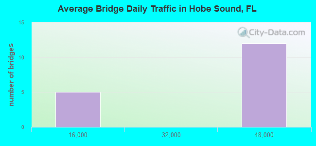
- 537,744Total average daily traffic
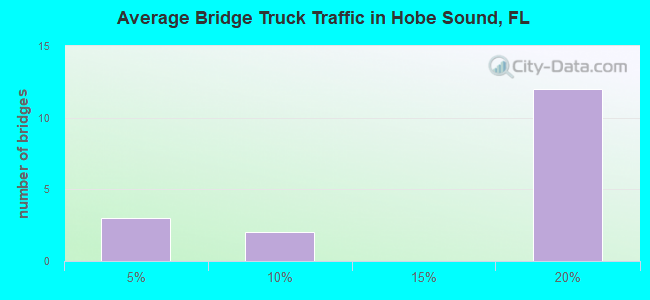
- 98,210Total average daily truck traffic
- National Bridge Inventory (NBI) Registered Bridges for Hobe Sound
- No street view available for this location
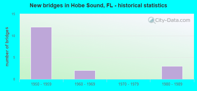
- New bridges - historical statistics
- 121950-1959
- 21960-1969
- 31980-1989
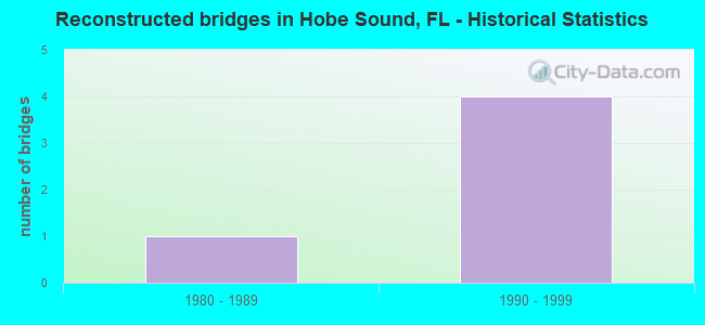
- Reconstructed bridges - Historical Statistics
- 11980-1989
- 41990-1999
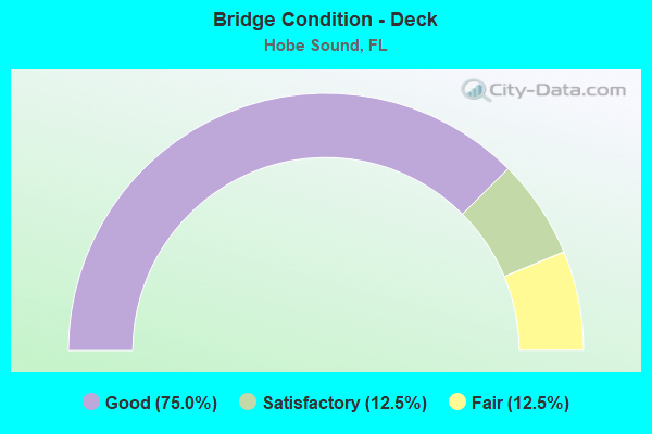
- Bridge Condition - Deck
- 75.0%Good
- 12.5%Satisfactory
- 12.5%Fair
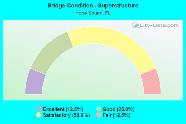
- Bridge Condition - Superstructure
- 12.5%Excellent
- 25.0%Good
- 50.0%Satisfactory
- 12.5%Fair
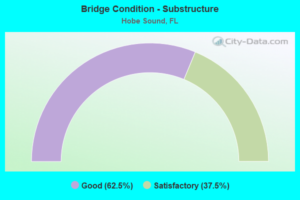
- Bridge Condition - Substructure
- 62.5%Good
- 37.5%Satisfactory
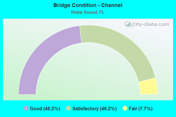
- Bridge Condition - Channel
- 46.2%Good
- 46.2%Satisfactory
- 7.7%Fair
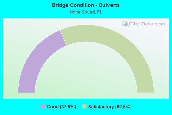
- Bridge Condition - Culverts
- 37.5%Good
- 62.5%Satisfactory
Find on map >> Show street view
Structure Number: 890001, Location: 1 Mile South of CR-708 (Lat: 27.043883, Lng: -80.117283), Route carried "on" structure: US 1, Year Built: 1956, Year Reconstructed: 2002, Status: Open, Structure Length: 5.97m (19.59ft), Average Daily Traffic: 9,700 (year 2020), Truck Traffic: 8%, Average Future Daily Traffic: 16,830 (year 2042), Design Load: HS 20, Features Intersected: FEC RR(Olympia Overpass)
Minimum Vertical Clearance: 30+ m (98+ ft), Kilometerpoint: 8.719, Lanes on structure: 2, Base Highway Network: Yes, Owner: State Highway Agency, Approaching Roadway Width: 10.8m (35.4ft), Skew: 3 degrees, Material/Design: Steel, Design/Construction: Stringer/Multi-beam, Number Of Spans In Main Unit: 5, Length of Maximum Span: 17.1m (56.1ft), Curb-To-Curb Width: 11.0m (36.1ft), Out-to-Out Width: 11.9m (39.0ft)
Condition: Deck: Good, Superstructure: Satisfactory, Substructure: Good, Operating Rating: 70.5 metric tons, Method Used To Determine Operating Rating: Load Factor (LF), Inventory Rating: 42.3 metric tons, Method Used To Determine Inventory Rating: Load Factor (LF), Structural Evaluation: Equal to present minimum criteria, Deck Geometry: Equal to present minimum criteria, Underclear: Equal to present minimum criteria, Approach Roadway Alignment: Equal to present desirable criteria, Designated Inspection Frequency: Every 24 months, Inspection Date: January 2021, Deck Structure Type: Concrete Cast-file-Place
Find on map >> Show street view
Structure Number: 890021, Location: 1 Mile South of CR-708 (Lat: 27.044300, Lng: -80.117333), Route carried "on" structure: US 1, Year Built: 1956, Year Reconstructed: 2002, Status: Open, Structure Length: 5.97m (19.59ft), Average Daily Traffic: 9,700 (year 2020), Truck Traffic: 8%, Average Future Daily Traffic: 16,830 (year 2042), Design Load: HS 20, Features Intersected: FEC RR(Olympia Overpass)
Minimum Vertical Clearance: 30+ m (98+ ft), Kilometerpoint: 8.719, Lanes on structure: 2, Base Highway Network: Yes, Owner: State Highway Agency, Approaching Roadway Width: 10.8m (35.4ft), Skew: 3 degrees, Material/Design: Steel, Design/Construction: Stringer/Multi-beam, Number Of Spans In Main Unit: 5, Length of Maximum Span: 17.1m (56.1ft), Curb-To-Curb Width: 11.0m (36.1ft), Out-to-Out Width: 11.9m (39.0ft)
Condition: Deck: Good, Superstructure: Satisfactory, Substructure: Good, Operating Rating: 70.5 metric tons, Method Used To Determine Operating Rating: Load Factor (LF), Inventory Rating: 42.3 metric tons, Method Used To Determine Inventory Rating: Load Factor (LF), Structural Evaluation: Equal to present minimum criteria, Deck Geometry: Equal to present minimum criteria, Underclear: Equal to present minimum criteria, Approach Roadway Alignment: Equal to present desirable criteria, Designated Inspection Frequency: Every 24 months, Inspection Date: January 2021, Deck Structure Type: Concrete Cast-file-Place
Find on map >> Show street view
Structure Number: 890072, Location: 0.67 MI N OF PLM BCH CO (Lat: 26.964781, Lng: -80.173125), Route carried "on" structure: State highway 91, Year Built: 1957, Year Reconstructed: 1990, Status: Open, Structure Length: 0.63m (2.07ft), Average Daily Traffic: 42,300 (year 2021), Truck Traffic: 19%, Average Future Daily Traffic: 73,390 (year 2042), Design Load: HS 20+Mod, Features Intersected: DRAINAGE CANAL
Minimum Vertical Clearance: 30+ m (98+ ft), Kilometerpoint: 1.027, Lanes on structure: 4, Base Highway Network: Yes, Toll: On toll road, Owner: State Toll Authority, Approaching Roadway Width: 26.5m (86.9ft), Skew: 30 degrees, Material/Design: Concrete, Design/Construction: Culvert, Number Of Spans In Main Unit: 2, Length of Maximum Span: 3.0m (9.8ft)
Condition: Channel: Satisfactory, Culverts: Good, Operating Rating: 65.7 metric tons, Method Used To Determine Operating Rating: Load Factor (LF), Inventory Rating: 39.4 metric tons, Method Used To Determine Inventory Rating: Load Factor (LF), Structural Evaluation: Better than present minimum criteria, Waterway Adequacy: Equal to present minimum criteria, Approach Roadway Alignment: Equal to present desirable criteria, Designated Inspection Frequency: Every 24 months, Inspection Date: November 2021
Find on map >> Show street view
Structure Number: 890073, Location: 2.5MI NORTH OF CO LINE (Lat: 26.986325, Lng: -80.188808), Route carried "on" structure: State highway 91, Year Built: 1957, Status: Open, Structure Length: 0.73m (2.40ft), Average Daily Traffic: 42,300 (year 2021), Truck Traffic: 19%, Average Future Daily Traffic: 73,390 (year 2042), Design Load: HS 20+Mod, Features Intersected: DRAINAGE CANAL
Minimum Vertical Clearance: 30+ m (98+ ft), Kilometerpoint: 3.870, Lanes on structure: 4, Base Highway Network: Yes, Toll: On toll road, Owner: State Toll Authority, Approaching Roadway Width: 26.5m (86.9ft), Skew: 30 degrees, Material/Design: Concrete, Design/Construction: Culvert, Number Of Spans In Main Unit: 2, Length of Maximum Span: 3.7m (12.1ft)
Condition: Channel: Satisfactory, Culverts: Satisfactory, Operating Rating: 65.7 metric tons, Method Used To Determine Operating Rating: Load Factor (LF), Inventory Rating: 39.4 metric tons, Method Used To Determine Inventory Rating: Load Factor (LF), Structural Evaluation: Equal to present minimum criteria, Waterway Adequacy: Equal to present minimum criteria, Approach Roadway Alignment: Equal to present desirable criteria, Designated Inspection Frequency: Every 24 months, Inspection Date: November 2021
Find on map >> Show street view
Structure Number: 890074, Location: 6 MI N OF PLM BEACH CO LI (Lat: 27.024183, Lng: -80.229983), Route carried "on" structure: State highway 91, Year Built: 1957, Status: Open, Structure Length: 0.75m (2.46ft), Average Daily Traffic: 42,300 (year 2021), Truck Traffic: 19%, Average Future Daily Traffic: 73,390 (year 2042), Design Load: HS 20+Mod, Features Intersected: DRAINAGE CANAL
Minimum Vertical Clearance: 30+ m (98+ ft), Kilometerpoint: 9.725, Lanes on structure: 4, Base Highway Network: Yes, Toll: On toll road, Owner: State Toll Authority, Approaching Roadway Width: 26.5m (86.9ft), Skew: 30 degrees, Material/Design: Concrete, Design/Construction: Culvert, Number Of Spans In Main Unit: 2, Length of Maximum Span: 3.7m (12.1ft)
Condition: Channel: Satisfactory, Culverts: Satisfactory, Operating Rating: 65.7 metric tons, Method Used To Determine Operating Rating: Load Factor (LF), Inventory Rating: 39.4 metric tons, Method Used To Determine Inventory Rating: Load Factor (LF), Structural Evaluation: Equal to present minimum criteria, Waterway Adequacy: Equal to present minimum criteria, Approach Roadway Alignment: Equal to present desirable criteria, Designated Inspection Frequency: Every 24 months, Inspection Date: November 2021
Find on map >> Show street view
Structure Number: 890075, Location: 0.25MI SOUTH OF SR-708 (Lat: 27.040400, Lng: -80.239400), Route carried "on" structure: State highway 91, Year Built: 1957, Status: Open, Structure Length: 0.67m (2.20ft), Average Daily Traffic: 42,300 (year 2021), Truck Traffic: 19%, Average Future Daily Traffic: 73,390 (year 2042), Design Load: HS 20+Mod, Features Intersected: DRAINAGE CANAL
Minimum Vertical Clearance: 30+ m (98+ ft), Kilometerpoint: 11.800, Lanes on structure: 4, Base Highway Network: Yes, Toll: On toll road, Owner: State Toll Authority, Approaching Roadway Width: 26.5m (86.9ft), Skew: 30 degrees, Material/Design: Concrete, Design/Construction: Culvert, Number Of Spans In Main Unit: 2, Length of Maximum Span: 3.4m (11.2ft)
Condition: Channel: Satisfactory, Culverts: Satisfactory, Operating Rating: 65.7 metric tons, Method Used To Determine Operating Rating: Load Factor (LF), Inventory Rating: 39.4 metric tons, Method Used To Determine Inventory Rating: Load Factor (LF), Structural Evaluation: Equal to present minimum criteria, Waterway Adequacy: Equal to present minimum criteria, Approach Roadway Alignment: Equal to present desirable criteria, Designated Inspection Frequency: Every 24 months, Inspection Date: November 2021
Find on map >> Show street view
Structure Number: 890076, Location: 0.45MI NORTH OF SR-708 (Lat: 27.050542, Lng: -80.239481), Route carried "on" structure: State highway 91, Year Built: 1959, Status: Open, Structure Length: 0.76m (2.49ft), Average Daily Traffic: 42,300 (year 2021), Truck Traffic: 19%, Average Future Daily Traffic: 73,390 (year 2042), Design Load: HS 20+Mod, Features Intersected: DRAINAGE CANAL
Minimum Vertical Clearance: 30+ m (98+ ft), Kilometerpoint: 12.925, Lanes on structure: 4, Base Highway Network: Yes, Toll: On toll road, Owner: State Toll Authority, Approaching Roadway Width: 34.1m (111.9ft), Skew: 30 degrees, Material/Design: Concrete, Design/Construction: Culvert, Number Of Spans In Main Unit: 2, Length of Maximum Span: 3.7m (12.1ft)
Condition: Channel: Satisfactory, Culverts: Good, Operating Rating: 65.7 metric tons, Method Used To Determine Operating Rating: Load Factor (LF), Inventory Rating: 39.4 metric tons, Method Used To Determine Inventory Rating: Load Factor (LF), Structural Evaluation: Better than present minimum criteria, Waterway Adequacy: Equal to present minimum criteria, Approach Roadway Alignment: Equal to present desirable criteria, Designated Inspection Frequency: Every 24 months, Inspection Date: December 2021
Find on map >> Show street view
Structure Number: 890077, Location: 1.8MI NORTH OF SR-708 (Lat: 27.069925, Lng: -80.245897), Route carried "on" structure: State highway 91, Year Built: 1957, Status: Open, Structure Length: 0.76m (2.49ft), Average Daily Traffic: 42,300 (year 2021), Truck Traffic: 19%, Average Future Daily Traffic: 73,390 (year 2042), Design Load: HS 20+Mod, Features Intersected: DRAINAGE CANAL
Minimum Vertical Clearance: 30+ m (98+ ft), Kilometerpoint: 15.171, Lanes on structure: 4, Base Highway Network: Yes, Toll: On toll road, Owner: State Toll Authority, Approaching Roadway Width: 27.4m (89.9ft), Skew: 30 degrees, Material/Design: Concrete, Design/Construction: Culvert, Number Of Spans In Main Unit: 2, Length of Maximum Span: 3.4m (11.2ft)
Condition: Channel: Good, Culverts: Satisfactory, Operating Rating: 71.8 metric tons, Method Used To Determine Operating Rating: Load Factor (LF), Inventory Rating: 43.0 metric tons, Method Used To Determine Inventory Rating: Load Factor (LF), Structural Evaluation: Equal to present minimum criteria, Waterway Adequacy: Equal to present minimum criteria, Approach Roadway Alignment: Equal to present desirable criteria, Designated Inspection Frequency: Every 24 months, Inspection Date: December 2021
Find on map >> Show street view
Structure Number: 890078, Location: 2.2 MI SOUTH OF SR-76 (Lat: 27.077378, Lng: -80.249250), Route carried "on" structure: State highway 91, Year Built: 1957, Status: Open, Structure Length: 0.76m (2.49ft), Average Daily Traffic: 42,300 (year 2021), Truck Traffic: 19%, Average Future Daily Traffic: 73,390 (year 2042), Design Load: HS 20+Mod, Features Intersected: DRAINAGE CANAL
Minimum Vertical Clearance: 30+ m (98+ ft), Kilometerpoint: 16.060, Lanes on structure: 4, Base Highway Network: Yes, Toll: On toll road, Owner: State Toll Authority, Approaching Roadway Width: 29.8m (97.8ft), Skew: 30 degrees, Material/Design: Concrete, Design/Construction: Culvert, Number Of Spans In Main Unit: 2, Length of Maximum Span: 3.4m (11.2ft)
Condition: Channel: Good, Culverts: Good, Operating Rating: 65.7 metric tons, Method Used To Determine Operating Rating: Load Factor (LF), Inventory Rating: 39.4 metric tons, Method Used To Determine Inventory Rating: Load Factor (LF), Structural Evaluation: Better than present minimum criteria, Waterway Adequacy: Equal to present minimum criteria, Approach Roadway Alignment: Equal to present desirable criteria, Designated Inspection Frequency: Every 24 months, Inspection Date: December 2021
Find on map >> Show street view
Structure Number: 890079, Location: 1.3 MI N OF PLM BCH CO LI (Lat: 26.972031, Lng: -80.178397), Route carried "on" structure: State highway 91, Year Built: 1956, Year Reconstructed: 1991, Status: Open, Structure Length: 5.49m (18.01ft), Average Daily Traffic: 42,300 (year 2021), Truck Traffic: 19%, Average Future Daily Traffic: 73,390 (year 2042), Design Load: HS 20+Mod, Features Intersected: CYPRESS CREEK #2
Minimum Vertical Clearance: 30+ m (98+ ft), Kilometerpoint: 1.963, Lanes on structure: 4, Base Highway Network: Yes, Toll: On toll road, Owner: State Toll Authority, Approaching Roadway Width: 26.2m (86.0ft), Skew: 30 degrees, Material/Design: Prestressed concrete, Design/Construction: Stringer/Multi-beam, Number Of Spans In Main Unit: 4, Length of Maximum Span: 13.7m (44.9ft), Curb-To-Curb Width: 26.2m (86.0ft), Out-to-Out Width: 27.7m (90.9ft)
Condition: Deck: Good, Superstructure: Excellent, Substructure: Satisfactory, Channel: Fair, Operating Rating: 42.5 metric tons, Method Used To Determine Operating Rating: Load and Resistance Factor (LRFR), Inventory Rating: 33.0 metric tons, Method Used To Determine Inventory Rating: Load and Resistance Factor (LRFR), Structural Evaluation: Equal to present minimum criteria, Deck Geometry: Superior to present desirable criteria, Waterway Adequacy: Equal to present minimum criteria, Approach Roadway Alignment: Equal to present desirable criteria, Designated Inspection Frequency: Every 24 months, Underwater Inspection Frequency: Every 24 months, Inspection Date: November 2021, Underwater Inspection Date: November 2021, Deck Structure Type: Concrete Cast-file-Place
Find on map >> Show street view
Structure Number: 890082, Location: 1.0MI NORTH OF SR-708 (Lat: 27.058942, Lng: -80.241081), Route carried "on" structure: State highway 91, Year Built: 1957, Year Reconstructed: 1990, Status: Open, Structure Length: 2.44m (8.01ft), Average Daily Traffic: 42,300 (year 2021), Truck Traffic: 19%, Average Future Daily Traffic: 73,390 (year 2042), Design Load: HS 20, Features Intersected: PHIPP CANAL
Minimum Vertical Clearance: 30+ m (98+ ft), Kilometerpoint: 13.858, Lanes on structure: 4, Base Highway Network: Yes, Toll: On toll road, Owner: State Toll Authority, Approaching Roadway Width: 27.1m (88.9ft), Skew: 30 degrees, Material/Design: Concrete, Design/Construction: Slab, Number Of Spans In Main Unit: 4, Length of Maximum Span: 6.1m (20.0ft), Curb-To-Curb Width: 26.8m (87.9ft), Out-to-Out Width: 27.7m (90.9ft)
Condition: Deck: Satisfactory, Superstructure: Satisfactory, Substructure: Good, Channel: Good, Operating Rating: 52.1 metric tons, Method Used To Determine Operating Rating: Load Factor (LF), Inventory Rating: 30.5 metric tons, Method Used To Determine Inventory Rating: Load Factor (LF), Structural Evaluation: Equal to present minimum criteria, Deck Geometry: Superior to present desirable criteria, Waterway Adequacy: Equal to present minimum criteria, Approach Roadway Alignment: Equal to present desirable criteria, Designated Inspection Frequency: Every 24 months, Inspection Date: December 2021, Deck Structure Type: Concrete Cast-file-Place
Find on map >> Show street view
Structure Number: 890084, Location: 0.9MI SOUTH OF SR-708 (Lat: 27.031431, Lng: -80.236447), Route carried "on" structure: State highway 91, Year Built: 1956, Status: Open, Structure Length: 0.67m (2.20ft), Average Daily Traffic: 42,300 (year 2021), Truck Traffic: 19%, Average Future Daily Traffic: 73,390 (year 2042), Design Load: HS 20+Mod, Features Intersected: DRAINAGE DITCH
Minimum Vertical Clearance: 30+ m (98+ ft), Kilometerpoint: 10.765, Lanes on structure: 4, Base Highway Network: Yes, Toll: On toll road, Owner: State Toll Authority, Approaching Roadway Width: 26.5m (86.9ft), Skew: 30 degrees, Material/Design: Concrete, Design/Construction: Culvert, Number Of Spans In Main Unit: 2, Length of Maximum Span: 3.4m (11.2ft)
Condition: Channel: Satisfactory, Culverts: Satisfactory, Operating Rating: 65.7 metric tons, Method Used To Determine Operating Rating: Load Factor (LF), Inventory Rating: 39.4 metric tons, Method Used To Determine Inventory Rating: Load Factor (LF), Structural Evaluation: Equal to present minimum criteria, Waterway Adequacy: Equal to present minimum criteria, Approach Roadway Alignment: Equal to present desirable criteria, Designated Inspection Frequency: Every 24 months, Inspection Date: November 2021
Find on map >> Show street view
Structure Number: 890107, Location: 0.9 M E OF US-1 ON CR-708 (Lat: 27.064667, Lng: -80.122303), Route carried "on" structure: County highway 708, Year Built: 1985, Status: Open, Structure Length: 11.66m (38.25ft), Average Daily Traffic: 10,502 (year 2021), Truck Traffic: 2%, Average Future Daily Traffic: 18,221 (year 2042), Design Load: HS 20, Features Intersected: INTRACOASTAL WATERWAY
Minimum Vertical Clearance: 30.45m (99.90ft), Kilometerpoint: 11.825, Lanes on structure: 2, Owner: County Highway Agency, Approaching Roadway Width: 8.3m (27.2ft), Navigation Control: Yes ( Vertical Clearance: 5.7m (18.7ft), Horizontal Clearance: 27.4m (89.9ft)), Material/Design: Steel, Design/Construction: Movable - Bascule, Number Of Spans In Main Unit: 1, Number Of Approach Spans: 4, Length of Maximum Span: 42.3m (138.8ft), Curb or Sidewalk Widths: Left: 2.6m (8.5ft), Right: 0.0m, Curb-To-Curb Width: 10.0m (32.8ft), Out-to-Out Width: 13.6m (44.6ft)
Condition: Deck: Good, Superstructure: Satisfactory, Substructure: Good, Channel: Good, Operating Rating: 56.6 metric tons, Method Used To Determine Operating Rating: Load Factor (LF), Inventory Rating: 33.9 metric tons, Method Used To Determine Inventory Rating: Load Factor (LF), Structural Evaluation: Equal to present minimum criteria, Deck Geometry: Meets minimum limits, Waterway Adequacy: Equal to present desirable criteria, Approach Roadway Alignment: Better than present minimum criteria, Designated Inspection Frequency: Every 24 months, Critical Feature Inspection Frequency: Every 24 months, Underwater Inspection Frequency: Every 24 months, Other Special Inspection Frequency: Every 12 months, Inspection Date: October 2021, Critical Feature Inspection Date: October 2021, Underwater Inspection Date: October 2021, Other Special Inspection Date: October 2021, Deck Structure Type: Open Grating
Find on map >> Show street view
Structure Number: 890119, Location: 0.1 MILE WEST OF I-95 (Lat: 27.044106, Lng: -80.239483), Route carried "on" structure: County highway 708, Year Built: 1986, Status: Open, Structure Length: 5.55m (18.21ft), Average Daily Traffic: 42,300 (year 2021), Truck Traffic: 19%, Average Future Daily Traffic: 73,390 (year 2042), Design Load: HS 20, Features Intersected: SR 91 TPK
Minimum Vertical Clearance: 30+ m (98+ ft), Kilometerpoint: 12.218, Lanes on structure: 4, Lanes under structure: 4, Owner: State Toll Authority, Approaching Roadway Width: 11.0m (36.1ft), Skew: 20 degrees, Material/Design: Prestressed concrete, Design/Construction: Stringer/Multi-beam, Number Of Spans In Main Unit: 2, Length of Maximum Span: 27.7m (90.9ft), Curb-To-Curb Width: 27.1m (88.9ft), Out-to-Out Width: 28.3m (92.8ft)
Condition: Deck: Good, Superstructure: Good, Substructure: Good, Operating Rating: 56.7 metric tons, Method Used To Determine Operating Rating: Load Factor (LF), Inventory Rating: 36.7 metric tons, Method Used To Determine Inventory Rating: Load Factor (LF), Structural Evaluation: Better than present minimum criteria, Deck Geometry: Superior to present desirable criteria, Underclear: Somewhat better than minimum adequacy, Approach Roadway Alignment: Better than present minimum criteria, Designated Inspection Frequency: Every 24 months, Inspection Date: November 2021, Deck Structure Type: Concrete Cast-file-Place
Find on map >> Show street view
Structure Number: 894017, Location: 0.2Mi E of GOMEZ AVE. (Lat: 27.078767, Lng: -80.134536), Route carried "on" structure: County highway , Year Built: 1968, Status: Posted for load-capacity, Structure Length: 0.91m (2.99ft), Average Daily Traffic: 121 (year 2021), Truck Traffic: 2%, Average Future Daily Traffic: 240 (year 2042), Design Load: HS 20, Features Intersected: CANAL, Facility Carried by Structure: SE HARBOR ISLAND
Minimum Vertical Clearance: 30+ m (98+ ft), Kilometerpoint: 0.000, Lanes on structure: 2, Owner: County Highway Agency, Approaching Roadway Width: 5.9m (19.4ft), Material/Design: Prestressed concrete, Design/Construction: Slab, Number Of Spans In Main Unit: 1, Length of Maximum Span: 9.1m (29.9ft), Curb or Sidewalk Widths: Left: 0.2m (0.7ft), Right: 1.2m (3.9ft), Curb-To-Curb Width: 6.8m (22.3ft), Out-to-Out Width: 8.6m (28.2ft)
Condition: Deck: Fair, Superstructure: Fair, Substructure: Satisfactory, Channel: Good, Inventory Rating: 68.9 metric tons, Method Used To Determine Inventory Rating: Load Factor (LF), Structural Evaluation: Somewhat better than minimum adequacy, Deck Geometry: Meets minimum limits, Waterway Adequacy: Better than present minimum criteria, Approach Roadway Alignment: Equal to present desirable criteria, Designated Inspection Frequency: Every 24 months, Underwater Inspection Frequency: Every 24 months, Inspection Date: December 2021, Underwater Inspection Date: December 2021, Deck Structure Type: Concrete Precast Panels, Wearing Surface/Protective System: Wearing Surface: Bituminous
Find on map >> Show street view
Structure Number: 894018, Location: 0.3Mi E of GOMEZ AVE. (Lat: 27.077811, Lng: -80.134894), Route carried "on" structure: County highway , Year Built: 1968, Status: Posted for load-capacity, Structure Length: 0.91m (2.99ft), Average Daily Traffic: 121 (year 2019), Truck Traffic: 2%, Average Future Daily Traffic: 180 (year 2041), Design Load: HS 20, Features Intersected: CANAL, Facility Carried by Structure: STAR ISLAND WAY
Minimum Vertical Clearance: 30+ m (98+ ft), Kilometerpoint: 0.000, Lanes on structure: 2, Owner: County Highway Agency, Approaching Roadway Width: 6.5m (21.3ft), Material/Design: Prestressed concrete, Design/Construction: Slab, Number Of Spans In Main Unit: 1, Length of Maximum Span: 9.1m (29.9ft), Curb or Sidewalk Widths: Left: 0.2m (0.7ft), Right: 1.2m (3.9ft), Curb-To-Curb Width: 6.8m (22.3ft), Out-to-Out Width: 8.6m (28.2ft)
Condition: Deck: Good, Superstructure: Good, Substructure: Satisfactory, Channel: Good, Inventory Rating: 68.9 metric tons, Method Used To Determine Inventory Rating: Load Factor (LF), Structural Evaluation: Equal to present minimum criteria, Deck Geometry: Meets minimum limits, Waterway Adequacy: Better than present minimum criteria, Approach Roadway Alignment: Better than present minimum criteria, Designated Inspection Frequency: Every 24 months, Underwater Inspection Frequency: Every 24 months, Inspection Date: December 2021, Underwater Inspection Date: December 2021, Deck Structure Type: Concrete Precast Panels, Wearing Surface/Protective System: Wearing Surface: Bituminous
Find on map >> Show street view
Structure Number: 890119, Location: 0.1 MILE WEST OF I-95 (Lat: 27.044106, Lng: -80.239483), Route carried "under" structure: State highway 91, Year Built: 1986, Structure Length: 0. m, Average Daily Traffic: 42,300 (year 2021), Truck Traffic: 19%, Features Intersected: SR 91 TPK, Facility Carried by Structure: CR708 125.4
Minimum Vertical Clearance: 4.97m (16.31ft), Kilometerpoint: 12.192, Lanes on structure: 4, Lanes under structure: 4, Toll: On toll road, Material/Design: Prestressed concrete, Design/Construction: Stringer/Multi-beam, Length of Maximum Span: 27.7m (90.9ft)