Bridge Statistics for Hokes Bluff, Alabama (AL)
Condition, Traffic, Stress, Structural Evaluation, Project Costs
- National Bridge Inventory (NBI) Statistics
- 15Number of bridges
- 174ft / 52.8mTotal length
- $22,609,000Total costs
- 89,061Total average daily traffic
- 5,232Total average daily truck traffic
- 126,623Total future (year 2020) average daily traffic
- National Bridge Inventory (NBI) Registered Bridges for Hokes Bluff
- No street view available for this location
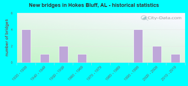
- New bridges - historical statistics
- 41930-1939
- 11940-1949
- 21950-1959
- 11960-1969
- 41990-1999
- 22000-2009
- 12010-2019


- Bridge Condition - Deck
- 11.1%Excellent
- 55.6%Good
- 22.2%Satisfactory
- 11.1%Fair

- Bridge Condition - Superstructure
- 11.1%Excellent
- 44.4%Good
- 11.1%Satisfactory
- 33.3%Fair

- Bridge Condition - Substructure
- 11.1%Excellent
- 44.4%Good
- 22.2%Satisfactory
- 22.2%Fair

- Bridge Condition - Channel
- 6.7%Excellent
- 6.7%Very good
- 46.7%Good
- 33.3%Satisfactory
- 6.7%Fair

- Bridge Condition - Culverts
- 50.0%Good
- 33.3%Satisfactory
- 16.7%Fair
Find on map >> Show street view
Structure Number: 1845, Location: AT INT WITH ALFORD BEND (Lat: 33.974019, Lng: -85.865008), Route carried "on" structure: County highway 201, Year Built: 1938, Status: Posted for load, Structure Length: 1.25m (4.10ft), Average Daily Traffic: 950 (year 2003), Truck Traffic: 10%, Average Future Daily Traffic: 1,416 (year 2032), Features Intersected: BIG COVE CREEK, Facility Carried by Structure: COLVIN GAP RD.
Minimum Vertical Clearance: 7.56m (24.80ft), Kilometerpoint: 0.010, Lanes on structure: 2, Owner: County Highway Agency, Approaching Roadway Width: 8.5m (27.9ft), Material/Design: Steel, Design/Construction: Stringer/Multi-beam, Number Of Spans In Main Unit: 2, Length of Maximum Span: 6.1m (20.0ft), Curb or Sidewalk Widths: Left: 0.3m (1.0ft), Right: 0.3m (1.0ft), Curb-To-Curb Width: 5.9m (19.4ft), Out-to-Out Width: 6.5m (21.3ft)
Condition: Deck: Satisfactory, Superstructure: Fair, Substructure: Satisfactory, Channel: Satisfactory, Operating Rating: 17.8 metric tons, Method Used To Determine Operating Rating: Allowable Stress (AS), Inventory Rating: 10.7 metric tons, Method Used To Determine Inventory Rating: Allowable Stress (AS), Structural Evaluation: High priority of replacement, Deck Geometry: High priority of replacement, Waterway Adequacy: Better than present minimum criteria, Approach Roadway Alignment: Equal to present minimum criteria, Bridge Posting: Required (Relationship of Operating Rating to Maximum Legal Load: > 39.9% below), Length Of Structure Improvement: 1.92m (6.30ft), Designated Inspection Frequency: Every 24 months, Other Special Inspection Frequency: Every 12 months, Inspection Date: August 2021, Other Special Inspection Date: August 2021, Bridge Improvement Cost: $277,000, Roadway Improvement Cost: $28,000, Total Project Cost: $305,000 ( Estimate for 2022), Deck Structure Type: Concrete Cast-file-Place
Find on map >> Show street view
Structure Number: 1851, Location: .05 MI EAST OF CNTY RD 71 (Lat: 34.000189, Lng: -85.845208), Route carried "on" structure: County highway 217, Year Built: 1938, Status: Open, Structure Length: 0.80m (2.62ft), Average Daily Traffic: 753 (year 2006), Truck Traffic: 10%, Average Future Daily Traffic: 1,077 (year 2032), Features Intersected: LITTLE DRY CREEK, Facility Carried by Structure: ROCKY FORD RD.
Minimum Vertical Clearance: 30+ m (98+ ft), Kilometerpoint: 0.010, Lanes on structure: 2, Owner: City or Municipal Highway Agency, Approaching Roadway Width: 7.3m (24.0ft), Material/Design: Concrete, Design/Construction: Culvert, Number Of Spans In Main Unit: 3, Length of Maximum Span: 2.7m (8.9ft)
Condition: Channel: Satisfactory, Culverts: Fair, Operating Rating: 88.9 metric tons, Method Used To Determine Operating Rating: Load Factor (LF), Inventory Rating: 88.9 metric tons, Method Used To Determine Inventory Rating: Load Factor (LF), Structural Evaluation: Somewhat better than minimum adequacy, Waterway Adequacy: Somewhat better than minimum adequacy, Approach Roadway Alignment: Better than present minimum criteria, Length Of Structure Improvement: 1.46m (4.79ft), Designated Inspection Frequency: Every 24 months, Inspection Date: November 2020, Bridge Improvement Cost: $219,000, Roadway Improvement Cost: $22,000, Total Project Cost: $241,000 ( Estimate for 2022)
Find on map >> Show street view
Structure Number: 2062, Location: 0.2 MI S OF FORDS VLLY RD (Lat: 33.966733, Lng: -85.841769), Route carried "on" structure: County highway 196, Year Built: 1939, Status: Posted for load, Structure Length: 0.88m (2.89ft), Average Daily Traffic: 353 (year 2004), Truck Traffic: 10%, Average Future Daily Traffic: 150 (year 2033), Features Intersected: BIG COVE CREEK, Facility Carried by Structure: OLD FORDS VALLEY
Minimum Vertical Clearance: 30+ m (98+ ft), Kilometerpoint: 0.010, Lanes on structure: 2, Owner: County Highway Agency, Approaching Roadway Width: 6.7m (22.0ft), Skew: 4 degrees, Material/Design: Steel, Design/Construction: Stringer/Multi-beam, Number Of Spans In Main Unit: 1, Length of Maximum Span: 8.8m (28.9ft), Curb or Sidewalk Widths: Left: 0.2m (0.7ft), Right: 0.2m (0.7ft), Curb-To-Curb Width: 5.6m (18.4ft), Out-to-Out Width: 6.2m (20.3ft)
Condition: Deck: Good, Superstructure: Satisfactory, Substructure: Satisfactory, Channel: Satisfactory, Operating Rating: 26.1 metric tons, Method Used To Determine Operating Rating: Allowable Stress (AS), Inventory Rating: 15.5 metric tons, Method Used To Determine Inventory Rating: Allowable Stress (AS), Structural Evaluation: Meets minimum limits, Deck Geometry: High priority of corrective action, Waterway Adequacy: Better than present minimum criteria, Approach Roadway Alignment: Better than present minimum criteria, Bridge Posting: Required (Relationship of Operating Rating to Maximum Legal Load: > 39.9% below), Length Of Structure Improvement: 1.55m (5.09ft), Designated Inspection Frequency: Every 24 months, Other Special Inspection Frequency: Every 12 months, Inspection Date: October 2021, Other Special Inspection Date: October 2021, Bridge Improvement Cost: $212,000, Roadway Improvement Cost: $21,000, Total Project Cost: $233,000 ( Estimate for 2022), Deck Structure Type: Concrete Cast-file-Place, Wearing Surface/Protective System: Wearing Surface: Bituminous
Find on map >> Show street view
Structure Number: 2473, Location: SIBERT ST (Lat: 33.981667, Lng: -85.870000), Route carried "on" structure: County highway 195, Year Built: 1940, Status: Posted for load, Structure Length: 1.22m (4.00ft), Average Daily Traffic: 170 (year 1991), Truck Traffic: 2%, Average Future Daily Traffic: 210 (year 2034), Features Intersected: BIG COVE CREEK, Facility Carried by Structure: SIBERT ST
Minimum Vertical Clearance: 7.56m (24.80ft), Kilometerpoint: 0.010, Lanes on structure: 2, Owner: City or Municipal Highway Agency, Approaching Roadway Width: 6.1m (20.0ft), Material/Design: Steel, Design/Construction: Stringer/Multi-beam, Number Of Spans In Main Unit: 2, Length of Maximum Span: 6.1m (20.0ft), Curb-To-Curb Width: 5.5m (18.0ft), Out-to-Out Width: 5.9m (19.4ft)
Condition: Deck: Fair, Superstructure: Fair, Substructure: Fair, Channel: Satisfactory, Operating Rating: 33.7 metric tons, Method Used To Determine Operating Rating: Allowable Stress (AS), Inventory Rating: 22.3 metric tons, Method Used To Determine Inventory Rating: Allowable Stress (AS), Structural Evaluation: Somewhat better than minimum adequacy, Deck Geometry: High priority of corrective action, Waterway Adequacy: Equal to present minimum criteria, Approach Roadway Alignment: Equal to present minimum criteria, Bridge Posting: Required (Relationship of Operating Rating to Maximum Legal Load: > 39.9% below), Length Of Structure Improvement: 1.89m (6.20ft), Designated Inspection Frequency: Every 24 months, Other Special Inspection Frequency: Every 12 months, Inspection Date: October 2020, Other Special Inspection Date: November 2021, Bridge Improvement Cost: $247,000, Roadway Improvement Cost: $25,000, Total Project Cost: $272,000 ( Estimate for 2022), Deck Structure Type: Concrete Cast-file-Place
Find on map >> Show street view
Structure Number: 6643, Location: WILLIAMS RD (Lat: 33.910806, Lng: -85.778711), Route carried "on" structure: County highway 63, Year Built: 1959, Status: Open, Structure Length: 1.10m (3.61ft), Average Daily Traffic: 310 (year 1993), Truck Traffic: 1%, Average Future Daily Traffic: 610 (year 2040), Features Intersected: COFFEE CREEK, Facility Carried by Structure: WILLIAMS RD.
Minimum Vertical Clearance: 30+ m (98+ ft), Kilometerpoint: 0.010, Lanes on structure: 2, Owner: County Highway Agency, Approaching Roadway Width: 9.8m (32.2ft), Material/Design: Steel, Design/Construction: Culvert, Number Of Spans In Main Unit: 2, Length of Maximum Span: 4.0m (13.1ft), Curb-To-Curb Width: 10.4m (34.1ft), Out-to-Out Width: 11.0m (36.1ft)
Condition: Channel: Good, Culverts: Good, Operating Rating: 51.9 metric tons, Method Used To Determine Operating Rating: Load Factor (LF), Inventory Rating: 45.4 metric tons, Method Used To Determine Inventory Rating: Load Factor (LF), Structural Evaluation: Better than present minimum criteria, Deck Geometry: Better than present minimum criteria, Waterway Adequacy: Equal to present minimum criteria, Approach Roadway Alignment: Equal to present minimum criteria, Length Of Structure Improvement: 1.77m (5.81ft), Designated Inspection Frequency: Every 24 months, Inspection Date: October 2020, Bridge Improvement Cost: $389,000, Roadway Improvement Cost: $39,000, Total Project Cost: $428,000 ( Estimate for 2022)
Find on map >> Show street view
Structure Number: 8082, Location: 1.1 MI W OF MAYES X RDS (Lat: 34.017825, Lng: -85.857894), Route carried "on" structure: County highway 220, Year Built: 1963, Status: Open, Structure Length: 1.02m (3.35ft), Average Daily Traffic: 300 (year 2003), Truck Traffic: 2%, Average Future Daily Traffic: 300 (year 2033), Design Load: H 15, Features Intersected: LITTLE DRY CREEK, Facility Carried by Structure: BACHELORS CHAPEL
Minimum Vertical Clearance: 30+ m (98+ ft), Kilometerpoint: 0.010, Lanes on structure: 2, Owner: County Highway Agency, Approaching Roadway Width: 7.9m (25.9ft), Material/Design: Concrete, Design/Construction: Culvert, Number Of Spans In Main Unit: 3, Length of Maximum Span: 3.2m (10.5ft)
Condition: Channel: Good, Culverts: Satisfactory, Operating Rating: 40.6 metric tons, Method Used To Determine Operating Rating: Load Factor (LF), Inventory Rating: 24.3 metric tons, Method Used To Determine Inventory Rating: Load Factor (LF), Structural Evaluation: Equal to present minimum criteria, Waterway Adequacy: Equal to present minimum criteria, Approach Roadway Alignment: Equal to present minimum criteria, Length Of Structure Improvement: 1.69m (5.54ft), Designated Inspection Frequency: Every 24 months, Inspection Date: October 2021, Bridge Improvement Cost: $411,000, Roadway Improvement Cost: $41,000, Total Project Cost: $452,000 ( Estimate for 2022)
Find on map >> Show street view
Structure Number: 9834, Location: OLD HWY 278 * COVE CREEK (Lat: 33.991667, Lng: -85.910000), Route carried "on" structure: City street , Year Built: 1930, Year Reconstructed: 1969, Status: Open, Structure Length: 3.38m (11.09ft), Average Daily Traffic: 12,660 (year 2003), Truck Traffic: 6%, Average Future Daily Traffic: 18,810 (year 2032), Design Load: H 15, Features Intersected: COVE CREEK, Facility Carried by Structure: OLD HWY 278
Minimum Vertical Clearance: 30+ m (98+ ft), Kilometerpoint: 221.220, Lanes on structure: 2, Base Highway Network: Yes, Owner: City or Municipal Highway Agency, Approaching Roadway Width: 8.5m (27.9ft), Material/Design: Concrete continuous, Design/Construction: Slab, Number Of Spans In Main Unit: 7, Length of Maximum Span: 5.5m (18.0ft), Curb-To-Curb Width: 9.3m (30.5ft), Out-to-Out Width: 9.9m (32.5ft)
Condition: Deck: Satisfactory, Superstructure: Fair, Substructure: Fair, Channel: Fair, Operating Rating: 43.5 metric tons, Method Used To Determine Operating Rating: Field evaluation and documented engineering judgment, Inventory Rating: 32.7 metric tons, Method Used To Determine Inventory Rating: Field evaluation and documented engineering judgment, Structural Evaluation: Somewhat better than minimum adequacy, Deck Geometry: High priority of corrective action, Waterway Adequacy: Equal to present minimum criteria, Approach Roadway Alignment: Equal to present desirable criteria, Length Of Structure Improvement: 4.27m (14.01ft), Designated Inspection Frequency: Every 24 months, Other Special Inspection Frequency: Every 24 months, Inspection Date: January 2021, Other Special Inspection Date: January 2021, Bridge Improvement Cost: $937,000, Roadway Improvement Cost: $94,000, Total Project Cost: $1,031,000 ( Estimate for 2022), Deck Structure Type: Concrete Cast-file-Place, Wearing Surface/Protective System: Wearing Surface: Bituminous
Find on map >> Show street view
Structure Number: 16383, Location: .7 MI W LITTLE COVE CREEK (Lat: 33.998719, Lng: -85.938600), Route carried "on" structure: State highway 74, Year Built: 2002, Status: Open, Structure Length: 4.21m (13.81ft), Average Daily Traffic: 14,367 (year 2018), Truck Traffic: 6%, Average Future Daily Traffic: 20,113 (year 2038), Design Load: HS 20, Features Intersected: LITTLE COVE CREEK RELIEF, Facility Carried by Structure: US 278
Minimum Vertical Clearance: 30+ m (98+ ft), Kilometerpoint: 219.836, Lanes on structure: 5, Base Highway Network: Yes, Owner: State Highway Agency, Approaching Roadway Width: 14.6m (47.9ft), Material/Design: Concrete, Design/Construction: Culvert, Number Of Spans In Main Unit: 3, Length of Maximum Span: 4.0m (13.1ft)
Condition: Channel: Satisfactory, Culverts: Satisfactory, Operating Rating: 72.2 metric tons, Method Used To Determine Operating Rating: Load Factor (LF), Inventory Rating: 43.4 metric tons, Method Used To Determine Inventory Rating: Load Factor (LF), Structural Evaluation: Equal to present minimum criteria, Waterway Adequacy: Equal to present desirable criteria, Approach Roadway Alignment: Equal to present desirable criteria, Length Of Structure Improvement: 5.18m (16.99ft), Designated Inspection Frequency: Every 24 months, Inspection Date: May 2020, Bridge Improvement Cost: $4,125,000, Roadway Improvement Cost: $413,000, Total Project Cost: $4,538,000 ( Estimate for 2022), Wearing Surface/Protective System: Wearing Surface: Bituminous
Find on map >> Show street view
Structure Number: 16384, Location: 2.5MILES EAST OF 431 (Lat: 33.995042, Lng: -85.924994), Route carried "on" structure: State highway 278, Year Built: 1998, Status: Open, Structure Length: 8.93m (29.30ft), Average Daily Traffic: 14,876 (year 2018), Truck Traffic: 6%, Average Future Daily Traffic: 20,826 (year 2038), Design Load: HS 20, Features Intersected: LITTLE COVE CREEK
Minimum Vertical Clearance: 7.56m (24.80ft), Kilometerpoint: 221.088, Lanes on structure: 3, Base Highway Network: Yes, Owner: State Highway Agency, Approaching Roadway Width: 15.8m (51.8ft), Material/Design: Prestressed concrete, Design/Construction: Stringer/Multi-beam, Number Of Spans In Main Unit: 3, Number Of Approach Spans: 2, Length of Maximum Span: 22.8m (74.8ft), Curb-To-Curb Width: 15.8m (51.8ft), Out-to-Out Width: 16.7m (54.8ft)
Condition: Deck: Good, Superstructure: Good, Substructure: Good, Channel: Good, Operating Rating: 62.6 metric tons, Method Used To Determine Operating Rating: Load Factor (LF), Inventory Rating: 37.5 metric tons, Method Used To Determine Inventory Rating: Load Factor (LF), Structural Evaluation: Better than present minimum criteria, Deck Geometry: Somewhat better than minimum adequacy, Waterway Adequacy: Equal to present desirable criteria, Approach Roadway Alignment: Equal to present desirable criteria, Length Of Structure Improvement: 9.90m (32.48ft), Designated Inspection Frequency: Every 24 months, Inspection Date: May 2020, Bridge Improvement Cost: $3,667,000, Roadway Improvement Cost: $367,000, Total Project Cost: $4,034,000 ( Estimate for 2022), Deck Structure Type: Concrete Cast-file-Place
Find on map >> Show street view
Structure Number: 16385, Location: US 278 @ BIG COVE CREEK (Lat: 33.987728, Lng: -85.908242), Route carried "on" structure: State highway 278, Year Built: 1998, Status: Open, Structure Length: 10.67m (35.01ft), Average Daily Traffic: 14,886 (year 2018), Truck Traffic: 6%, Average Future Daily Traffic: 20,826 (year 2038), Design Load: HS 20, Features Intersected: BIG COVE CREEK
Minimum Vertical Clearance: 30+ m (98+ ft), Kilometerpoint: 222.894, Lanes on structure: 2, Base Highway Network: Yes, Owner: State Highway Agency, Approaching Roadway Width: 12.2m (40.0ft), Skew: 2 degrees, Material/Design: Prestressed concrete, Design/Construction: Stringer/Multi-beam, Number Of Spans In Main Unit: 5, Length of Maximum Span: 21.3m (69.9ft), Curb-To-Curb Width: 12.2m (40.0ft), Out-to-Out Width: 13.0m (42.7ft)
Condition: Deck: Good, Superstructure: Good, Substructure: Good, Channel: Very good, Operating Rating: 85.0 metric tons, Method Used To Determine Operating Rating: Load Factor (LF), Inventory Rating: 49.9 metric tons, Method Used To Determine Inventory Rating: Load Factor (LF), Structural Evaluation: Better than present minimum criteria, Deck Geometry: Better than present minimum criteria, Waterway Adequacy: Equal to present desirable criteria, Approach Roadway Alignment: Equal to present desirable criteria, Length Of Structure Improvement: 11.57m (37.96ft), Designated Inspection Frequency: Every 24 months, Inspection Date: May 2020, Bridge Improvement Cost: $3,333,000, Roadway Improvement Cost: $333,000, Total Project Cost: $3,666,000 ( Estimate for 2022), Deck Structure Type: Concrete Cast-file-Place
Find on map >> Show street view
Structure Number: 16386, Location: US 278 @ BIG COVE CREEK (Lat: 33.987972, Lng: -85.908142), Route carried "on" structure: State highway 278, Year Built: 1998, Status: Open, Structure Length: 10.67m (35.01ft), Average Daily Traffic: 14,867 (year 2018), Truck Traffic: 6%, Average Future Daily Traffic: 20,826 (year 2038), Design Load: HS 20, Features Intersected: BIG COVE CREEK
Minimum Vertical Clearance: 7.56m (24.80ft), Kilometerpoint: 222.894, Lanes on structure: 2, Base Highway Network: Yes, Owner: State Highway Agency, Approaching Roadway Width: 12.2m (40.0ft), Skew: 2 degrees, Material/Design: Prestressed concrete, Design/Construction: Stringer/Multi-beam, Number Of Spans In Main Unit: 5, Length of Maximum Span: 21.3m (69.9ft), Curb-To-Curb Width: 12.2m (40.0ft), Out-to-Out Width: 13.1m (43.0ft)
Condition: Deck: Good, Superstructure: Good, Substructure: Good, Channel: Good, Operating Rating: 85.0 metric tons, Method Used To Determine Operating Rating: Load Factor (LF), Inventory Rating: 49.9 metric tons, Method Used To Determine Inventory Rating: Load Factor (LF), Structural Evaluation: Better than present minimum criteria, Deck Geometry: Better than present minimum criteria, Waterway Adequacy: Equal to present desirable criteria, Approach Roadway Alignment: Equal to present desirable criteria, Length Of Structure Improvement: 11.57m (37.96ft), Designated Inspection Frequency: Every 24 months, Inspection Date: May 2020, Bridge Improvement Cost: $3,333,000, Roadway Improvement Cost: $333,000, Total Project Cost: $3,666,000 ( Estimate for 2022), Deck Structure Type: Concrete Cast-file-Place
Find on map >> Show street view
Structure Number: 16387, Location: 1.8 MI.E. BIG COVE CK (Lat: 33.983478, Lng: -85.827686), Route carried "on" structure: State highway 74, Year Built: 1998, Status: Open, Structure Length: 0.67m (2.20ft), Average Daily Traffic: 11,669 (year 2020), Truck Traffic: 4%, Average Future Daily Traffic: 16,337 (year 2040), Design Load: HS 20, Features Intersected: CREEK, Facility Carried by Structure: US 278
Minimum Vertical Clearance: 30+ m (98+ ft), Kilometerpoint: 225.500, Lanes on structure: 6, Base Highway Network: Yes, Owner: State Highway Agency, Approaching Roadway Width: 21.9m (71.9ft), Material/Design: Concrete, Design/Construction: Culvert, Number Of Spans In Main Unit: 2, Length of Maximum Span: 3.0m (9.8ft), Curb-To-Curb Width: 68.3m (224.1ft), Out-to-Out Width: 68.6m (225.1ft)
Condition: Channel: Good, Culverts: Good, Operating Rating: 88.9 metric tons, Method Used To Determine Operating Rating: Load Factor (LF), Inventory Rating: 60.9 metric tons, Method Used To Determine Inventory Rating: Load Factor (LF), Structural Evaluation: Better than present minimum criteria, Deck Geometry: Superior to present desirable criteria, Waterway Adequacy: Equal to present minimum criteria, Approach Roadway Alignment: Equal to present desirable criteria, Length Of Structure Improvement: 1.30m (4.27ft), Designated Inspection Frequency: Every 24 months, Inspection Date: October 2021, Bridge Improvement Cost: $1,689,000, Roadway Improvement Cost: $169,000, Total Project Cost: $1,858,000 ( Estimate for 2022)
Find on map >> Show street view
Structure Number: 1879, Location: ?Caddell Circle (Lat: 33.997731, Lng: -85.923597), Route carried "on" structure: City street , Year Built: 2018, Status: Open, Structure Length: 3.66m (12.01ft), Design Load: HS 20, Features Intersected: Big Cove Creek, Facility Carried by Structure: Caddell Circle
Minimum Vertical Clearance: 30+ m (98+ ft), Kilometerpoint: 0.499, Lanes on structure: 2, Owner: City or Municipal Highway Agency, Approaching Roadway Width: 5.5m (18.0ft), Material/Design: Concrete, Design/Construction: Channel Beam, Number Of Spans In Main Unit: 3, Length of Maximum Span: 12.2m (40.0ft), Curb-To-Curb Width: 5.5m (18.0ft), Out-to-Out Width: 5.8m (19.0ft)
Condition: Deck: Excellent, Superstructure: Excellent, Substructure: Excellent, Channel: Excellent, Operating Rating: 82.6 metric tons, Method Used To Determine Operating Rating: Load Factor (LF), Inventory Rating: 49.4 metric tons, Method Used To Determine Inventory Rating: Load Factor (LF), Structural Evaluation: Superior to present desirable criteria, Deck Geometry: High priority of corrective action, Waterway Adequacy: Somewhat better than minimum adequacy, Approach Roadway Alignment: Somewhat better than minimum adequacy, Length Of Structure Improvement: 4.58m (15.03ft), Designated Inspection Frequency: Every 24 months, Inspection Date: November 2020, Bridge Improvement Cost: $596,000, Roadway Improvement Cost: $60,000, Total Project Cost: $656,000 ( Estimate for 2022), Deck Structure Type: Concrete Precast Panels
Find on map >> Show street view
Structure Number: 18804, Location: 0.4 MI PAST ROCKY FORD RD (Lat: 34.004986, Lng: -85.848517), Route carried "on" structure: County highway 221, Year Built: 2003, Status: Open, Structure Length: 3.66m (12.01ft), Average Daily Traffic: 1,600 (year 2002), Truck Traffic: 10%, Average Future Daily Traffic: 3,072 (year 2035), Design Load: HS 20, Features Intersected: LITTLE DRY CREEK, Facility Carried by Structure: COUNTY ROAD 71
Minimum Vertical Clearance: 9.14m (29.99ft), Kilometerpoint: 0.010, Lanes on structure: 2, Owner: County Highway Agency, Approaching Roadway Width: 8.5m (27.9ft), Material/Design: Concrete, Design/Construction: Channel Beam, Number Of Spans In Main Unit: 3, Length of Maximum Span: 12.2m (40.0ft), Curb-To-Curb Width: 8.5m (27.9ft), Out-to-Out Width: 8.5m (27.9ft)
Condition: Deck: Good, Superstructure: Good, Substructure: Good, Channel: Good, Operating Rating: 88.9 metric tons, Method Used To Determine Operating Rating: Load Factor (LF), Inventory Rating: 55.6 metric tons, Method Used To Determine Inventory Rating: Load Factor (LF), Structural Evaluation: Better than present minimum criteria, Deck Geometry: Somewhat better than minimum adequacy, Waterway Adequacy: Equal to present desirable criteria, Approach Roadway Alignment: Better than present minimum criteria, Length Of Structure Improvement: 4.58m (15.03ft), Designated Inspection Frequency: Every 24 months, Inspection Date: October 2021, Bridge Improvement Cost: $847,000, Roadway Improvement Cost: $85,000, Total Project Cost: $932,000 ( Estimate for 2022), Deck Structure Type: Concrete Precast Panels, Wearing Surface/Protective System: Wearing Surface: Integral Concrete
Find on map >> Show street view
Structure Number: 20712, Location: 200'S OF RABBITOWN RD. (Lat: 33.966897, Lng: -85.863408), Route carried "on" structure: County highway 21, Year Built: 1956, Status: Open, Structure Length: 0.67m (2.20ft), Average Daily Traffic: 1,300 (year 2012), Truck Traffic: 7%, Average Future Daily Traffic: 2,050 (year 2035), Design Load: HS 20, Features Intersected: UT TO BIG COVE CREEK, Facility Carried by Structure: COLVIN GAP RD.
Minimum Vertical Clearance: 30+ m (98+ ft), Kilometerpoint: 0.000, Lanes on structure: 2, Owner: County Highway Agency, Approaching Roadway Width: 8.5m (27.9ft), Material/Design: Concrete, Design/Construction: Culvert, Number Of Spans In Main Unit: 2, Length of Maximum Span: 3.2m (10.5ft)
Condition: Channel: Good, Culverts: Good, Operating Rating: 49.8 metric tons, Method Used To Determine Operating Rating: Load Factor (LF), Inventory Rating: 29.8 metric tons, Method Used To Determine Inventory Rating: Load Factor (LF), Structural Evaluation: Better than present minimum criteria, Waterway Adequacy: Equal to present desirable criteria, Approach Roadway Alignment: Somewhat better than minimum adequacy, Length Of Structure Improvement: 1.30m (4.27ft), Designated Inspection Frequency: Every 24 months, Inspection Date: January 2021, Bridge Improvement Cost: $270,000, Roadway Improvement Cost: $27,000, Total Project Cost: $297,000 ( Estimate for 2022), Wearing Surface/Protective System: Wearing Surface: Bituminous