Bridge Statistics for Holbrook, Arizona (AZ)
Condition, Traffic, Stress, Structural Evaluation, Project Costs
- National Bridge Inventory (NBI) Statistics
- 35Number of bridges
- 469ft / 143mTotal length
- $1,005,000Total costs
- 226,205Total average daily traffic
- 57,303Total average daily truck traffic
- National Bridge Inventory (NBI) Registered Bridges for Holbrook
- No street view available for this location
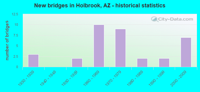
- New bridges - historical statistics
- 31930-1939
- 21950-1959
- 101960-1969
- 91970-1979
- 21980-1989
- 21990-1999
- 72000-2009

- Reconstructed bridges - Historical Statistics
- 11960-1969
- 11970-1979
- 01980-1989
- 01990-1999
- 12000-2009
- 22010-2019


- Bridge Condition - Deck
- 20.0%Very good
- 26.7%Good
- 33.3%Satisfactory
- 20.0%Fair

- Bridge Condition - Superstructure
- 26.7%Very good
- 26.7%Good
- 33.3%Satisfactory
- 6.7%Fair
- 6.7%Poor

- Bridge Condition - Substructure
- 20.0%Very good
- 33.3%Good
- 13.3%Satisfactory
- 33.3%Fair

- Bridge Condition - Channel
- 20.0%Very good
- 46.7%Good
- 20.0%Satisfactory
- 13.3%Fair

- Bridge Condition - Culverts
- 14.3%Very good
- 42.9%Good
- 42.9%Satisfactory
Find on map >> Show street view
Structure Number: 667, Location: 3.1 mi E Jct SR 77 (Lat: 34.882739, Lng: -110.108992), Route carried "on" structure: US 180, Year Built: 1961, Status: Open, Structure Length: 5.06m (16.60ft), Average Daily Traffic: 799 (year 2020), Truck Traffic: 9%, Average Future Daily Traffic: 809 (year 2040), Design Load: HS 20, Features Intersected: Little Colorado River
Minimum Vertical Clearance: 30+ m (98+ ft), Kilometerpoint: 499.556, Lanes on structure: 2, Owner: State Highway Agency, Approaching Roadway Width: 10.4m (34.1ft), Skew: 2 degrees, Material/Design: Steel continuous, Design/Construction: Stringer/Multi-beam, Number Of Spans In Main Unit: 3, Length of Maximum Span: 18.9m (62.0ft), Curb or Sidewalk Widths: Left: 0.5m (1.6ft), Right: 0.5m (1.6ft), Curb-To-Curb Width: 9.1m (29.9ft), Out-to-Out Width: 10.7m (35.1ft)
Condition: Deck: Fair, Superstructure: Satisfactory, Substructure: Fair, Channel: Good, Operating Rating: 55.3 metric tons, Method Used To Determine Operating Rating: Load Factor (LF), Inventory Rating: 32.7 metric tons, Method Used To Determine Inventory Rating: Load Factor (LF), Structural Evaluation: Somewhat better than minimum adequacy, Deck Geometry: Equal to present minimum criteria, Waterway Adequacy: Equal to present desirable criteria, Approach Roadway Alignment: Equal to present minimum criteria, Length Of Structure Improvement: 6.08m (19.95ft), Designated Inspection Frequency: Every 24 months, Inspection Date: August 2021, Total Project Cost: $1,000 ( Estimate for 2021), Deck Structure Type: Concrete Cast-file-Place, Wearing Surface/Protective System: Wearing Surface: Monolithic Concrete
Find on map >> Show street view
Structure Number: 948, Location: 1.8 mi E Jct SR 77 (Lat: 34.885600, Lng: -110.131600), Route carried "on" structure: US 180, Year Built: 1931, Year Reconstructed: 1967, Status: Open, Structure Length: 2.01m (6.59ft), Average Daily Traffic: 875 (year 2019), Truck Traffic: 13%, Average Future Daily Traffic: 885 (year 2041), Design Load: HS 20, Features Intersected: Five Mile Wash
Minimum Vertical Clearance: 30+ m (98+ ft), Kilometerpoint: 497.464, Lanes on structure: 2, Owner: State Highway Agency, Approaching Roadway Width: 12.2m (40.0ft), Skew: 3 degrees, Material/Design: Concrete, Design/Construction: Tee Beam, Number Of Spans In Main Unit: 2, Length of Maximum Span: 9.8m (32.2ft), Curb-To-Curb Width: 12.2m (40.0ft), Out-to-Out Width: 13.0m (42.7ft)
Condition: Deck: Fair, Superstructure: Fair, Substructure: Fair, Channel: Satisfactory, Operating Rating: 47.2 metric tons, Method Used To Determine Operating Rating: Load Factor (LF), Inventory Rating: 28.1 metric tons, Method Used To Determine Inventory Rating: Load Factor (LF), Structural Evaluation: Somewhat better than minimum adequacy, Deck Geometry: Equal to present desirable criteria, Waterway Adequacy: Equal to present minimum criteria, Approach Roadway Alignment: Equal to present desirable criteria, Length Of Structure Improvement: 2.80m (9.19ft), Designated Inspection Frequency: Every 24 months, Inspection Date: June 2021, Total Project Cost: $1,000 ( Estimate for 2021), Deck Structure Type: Concrete Cast-file-Place, Wearing Surface/Protective System: Wearing Surface: Bituminous
Find on map >> Show street view
Structure Number: 137, Location: 3.0 mi W Jct SR 77 (Lat: 34.939200, Lng: -110.129200), Route carried "on" structure: Interstate 40, Year Built: 1969, Status: Open, Structure Length: 8.17m (26.80ft), Average Daily Traffic: 13,297 (year 2020), Truck Traffic: 15%, Average Future Daily Traffic: 13,307 (year 2040), Design Load: HS 20, Features Intersected: SB 40
Minimum Vertical Clearance: 30+ m (98+ ft), Kilometerpoint: 466.388, Lanes on structure: 2, Lanes under structure: 2, Owner: State Highway Agency, Approaching Roadway Width: 11.6m (38.1ft), Skew: 5 degrees, Material/Design: Steel continuous, Design/Construction: Stringer/Multi-beam, Number Of Spans In Main Unit: 3, Length of Maximum Span: 30.5m (100.1ft), Curb-To-Curb Width: 11.6m (38.1ft), Out-to-Out Width: 12.4m (40.7ft)
Condition: Deck: Fair, Superstructure: Poor, Substructure: Fair, Operating Rating: 60.8 metric tons, Method Used To Determine Operating Rating: Load Factor (LF), Inventory Rating: 36.3 metric tons, Method Used To Determine Inventory Rating: Load Factor (LF), Structural Evaluation: Meets minimum limits, Deck Geometry: Equal to present minimum criteria, Underclear: High priority of corrective action, Approach Roadway Alignment: Equal to present desirable criteria, Length Of Structure Improvement: 1.83m (6.00ft), Designated Inspection Frequency: Every 24 months, Inspection Date: June 2021, Bridge Improvement Cost: $240,000, Roadway Improvement Cost: $75,000, Total Project Cost: $990,000 ( Estimate for 2021), Deck Structure Type: Concrete Cast-file-Place, Wearing Surface/Protective System: Wearing Surface: Monolithic Concrete
Find on map >> Show street view
Structure Number: 1772, Location: 8.8 mi W Jct SR 77 (Lat: 34.905800, Lng: -110.200900), Route carried "on" structure: Interstate 40, Year Built: 1977, Year Reconstructed: 2015, Status: Open, Structure Length: 13.38m (43.90ft), Average Daily Traffic: 10,203 (year 2020), Truck Traffic: 40%, Average Future Daily Traffic: 10,213 (year 2040), Design Load: HS 20, Features Intersected: Leroux Wash
Minimum Vertical Clearance: 30+ m (98+ ft), Kilometerpoint: 457.553, Lanes on structure: 2, Owner: State Highway Agency, Approaching Roadway Width: 11.6m (38.1ft), Skew: 4 degrees, Material/Design: Prestressed concrete, Design/Construction: Box Beam or Girders - Multiple, Number Of Spans In Main Unit: 6, Length of Maximum Span: 22.3m (73.2ft), Curb-To-Curb Width: 12.8m (42.0ft), Out-to-Out Width: 13.5m (44.3ft)
Condition: Deck: Satisfactory, Superstructure: Satisfactory, Substructure: Fair, Channel: Satisfactory, Operating Rating: 68.0 metric tons, Method Used To Determine Operating Rating: Load Factor (LF), Inventory Rating: 34.5 metric tons, Method Used To Determine Inventory Rating: Load Factor (LF), Structural Evaluation: Somewhat better than minimum adequacy, Deck Geometry: Equal to present desirable criteria, Waterway Adequacy: Equal to present desirable criteria, Approach Roadway Alignment: Equal to present desirable criteria, Designated Inspection Frequency: Every 24 months, Inspection Date: June 2021, Deck Structure Type: Concrete Cast-file-Place, Wearing Surface/Protective System: Wearing Surface: Monolithic Concrete
Find on map >> Show street view
Structure Number: 1773, Location: 8.8 mi W Jct SR 77 (Lat: 34.906100, Lng: -110.200500), Route carried "on" structure: Interstate 40, Year Built: 1977, Year Reconstructed: 2015, Status: Open, Structure Length: 13.38m (43.90ft), Average Daily Traffic: 8,582 (year 2020), Truck Traffic: 40%, Average Future Daily Traffic: 8,592 (year 2040), Design Load: HS 20, Features Intersected: Leroux Wash
Minimum Vertical Clearance: 30+ m (98+ ft), Kilometerpoint: 457.553, Lanes on structure: 2, Owner: State Highway Agency, Approaching Roadway Width: 11.6m (38.1ft), Skew: 4 degrees, Material/Design: Prestressed concrete, Design/Construction: Box Beam or Girders - Multiple, Number Of Spans In Main Unit: 6, Length of Maximum Span: 22.3m (73.2ft), Curb-To-Curb Width: 12.8m (42.0ft), Out-to-Out Width: 13.5m (44.3ft)
Condition: Deck: Good, Superstructure: Satisfactory, Substructure: Fair, Channel: Fair, Operating Rating: 68.0 metric tons, Method Used To Determine Operating Rating: Load Factor (LF), Inventory Rating: 34.5 metric tons, Method Used To Determine Inventory Rating: Load Factor (LF), Structural Evaluation: Somewhat better than minimum adequacy, Deck Geometry: Equal to present desirable criteria, Waterway Adequacy: Equal to present desirable criteria, Approach Roadway Alignment: Equal to present desirable criteria, Designated Inspection Frequency: Every 24 months, Inspection Date: June 2021, Deck Structure Type: Concrete Cast-file-Place, Wearing Surface/Protective System: Wearing Surface: Monolithic Concrete
Find on map >> Show street view
Structure Number: 1775, Location: 7.6 mi W Jct SR 77 (Lat: 34.906000, Lng: -110.186100), Route carried "on" structure: Interstate 40, Year Built: 1977, Status: Open, Structure Length: 4.27m (14.01ft), Average Daily Traffic: 10,053 (year 2019), Truck Traffic: 34%, Average Future Daily Traffic: 10,063 (year 2039), Design Load: HS 20, Features Intersected: B 40
Minimum Vertical Clearance: 30+ m (98+ ft), Kilometerpoint: 459.120, Lanes on structure: 2, Lanes under structure: 2, Owner: State Highway Agency, Approaching Roadway Width: 11.6m (38.1ft), Material/Design: Prestressed concrete, Design/Construction: Box Beam or Girders - Single/Spread, Number Of Spans In Main Unit: 1, Length of Maximum Span: 42.1m (138.1ft), Curb-To-Curb Width: 12.7m (41.7ft), Out-to-Out Width: 13.6m (44.6ft)
Condition: Deck: Satisfactory, Superstructure: Satisfactory, Substructure: Good, Operating Rating: 72.6 metric tons, Method Used To Determine Operating Rating: Load Factor (LF), Inventory Rating: 32.7 metric tons, Method Used To Determine Inventory Rating: Load Factor (LF), Structural Evaluation: Equal to present minimum criteria, Deck Geometry: Better than present minimum criteria, Underclear: Better than present minimum criteria, Approach Roadway Alignment: Equal to present desirable criteria, Designated Inspection Frequency: Every 24 months, Inspection Date: June 2021, Deck Structure Type: Concrete Cast-file-Place, Wearing Surface/Protective System: Wearing Surface: Monolithic Concrete
Find on map >> Show street view
Structure Number: 1776, Location: 9.5 mi W Jct SR 77 (Lat: 34.907000, Lng: -110.212500), Route carried "on" structure: County highway , Year Built: 1977, Status: Open, Structure Length: 7.71m (25.30ft), Average Daily Traffic: 1,800 (year 2013), Truck Traffic: 5%, Average Future Daily Traffic: 1,810 (year 2037), Design Load: HS 20, Features Intersected: I-40, Facility Carried by Structure: Perkins Valley Rd
Minimum Vertical Clearance: 30+ m (98+ ft), Kilometerpoint: 0.000, Lanes on structure: 2, Lanes under structure: 4, Owner: State Highway Agency, Approaching Roadway Width: 7.9m (25.9ft), Material/Design: Steel continuous, Design/Construction: Stringer/Multi-beam, Number Of Spans In Main Unit: 2, Length of Maximum Span: 37.8m (124.0ft), Curb-To-Curb Width: 7.9m (25.9ft), Out-to-Out Width: 8.7m (28.5ft)
Condition: Deck: Satisfactory, Superstructure: Good, Substructure: Satisfactory, Operating Rating: 65.3 metric tons, Method Used To Determine Operating Rating: Load Factor (LF), Inventory Rating: 39.0 metric tons, Method Used To Determine Inventory Rating: Load Factor (LF), Structural Evaluation: Equal to present minimum criteria, Deck Geometry: Meets minimum limits, Underclear: Somewhat better than minimum adequacy, Approach Roadway Alignment: Equal to present minimum criteria, Designated Inspection Frequency: Every 24 months, Inspection Date: September 2020, Deck Structure Type: Concrete Cast-file-Place, Wearing Surface/Protective System: Wearing Surface: Monolithic Concrete
Find on map >> Show street view
Structure Number: 203, Location: 0.4 mi N Jct US 180 (Lat: 34.894100, Lng: -110.160000), Route carried "on" structure: State highway 77, Year Built: 1988, Status: Open, Structure Length: 52.70m (172.90ft), Average Daily Traffic: 1,064 (year 2020), Truck Traffic: 7%, Average Future Daily Traffic: 1,074 (year 2041), Design Load: HS 20, Features Intersected: Little Colorado River
Minimum Vertical Clearance: 30+ m (98+ ft), Kilometerpoint: 624.586, Lanes on structure: 4, Lanes under structure: 4, Owner: State Highway Agency, Approaching Roadway Width: 15.8m (51.8ft), Material/Design: Prestressed concrete continuous, Design/Construction: Stringer/Multi-beam, Number Of Spans In Main Unit: 17, Length of Maximum Span: 31.1m (102.0ft), Curb or Sidewalk Widths: Left: 1.8m (5.9ft), Right: 0.0m, Curb-To-Curb Width: 15.8m (51.8ft), Out-to-Out Width: 18.9m (62.0ft)
Condition: Deck: Satisfactory, Superstructure: Good, Substructure: Satisfactory, Channel: Good, Operating Rating: 56.2 metric tons, Method Used To Determine Operating Rating: Load Factor (LF), Inventory Rating: 32.7 metric tons, Method Used To Determine Inventory Rating: Load Factor (LF), Structural Evaluation: Equal to present minimum criteria, Deck Geometry: Meets minimum limits, Underclear: High priority of replacement, Waterway Adequacy: Equal to present desirable criteria, Approach Roadway Alignment: Equal to present desirable criteria, Length Of Structure Improvement: 55.11m (180.81ft), Designated Inspection Frequency: Every 24 months, Inspection Date: May 2021, Bridge Improvement Cost: $7,000, Total Project Cost: $9,000 ( Estimate for 2021), Deck Structure Type: Concrete Cast-file-Place, Wearing Surface/Protective System: Wearing Surface: Monolithic Concrete, Deck Protection: Epoxy Coated Reinforcing
Find on map >> Show street view
Structure Number: 2402, Location: 1.4 mi W Jct SR 77 (Lat: 34.923700, Lng: -110.138100), Route carried "on" structure: , Year Built: 1994, Status: Open, Structure Length: 10.42m (34.19ft), Truck Traffic: 43%, Design Load: Pedestrian, Features Intersected: I-40, Facility Carried by Structure: Pedestrian OP
Kilometerpoint: 0.000, Lanes under structure: 4, Owner: State Highway Agency, Skew: 3 degrees, Material/Design: Steel continuous, Design/Construction: Stringer/Multi-beam, Number Of Spans In Main Unit: 4, Length of Maximum Span: 30.2m (99.1ft), Out-to-Out Width: 3.0m (9.8ft)
Condition: Deck: Good, Superstructure: Good, Substructure: Good, Structural Evaluation: Better than present minimum criteria, Underclear: Meets minimum limits, Designated Inspection Frequency: Every 24 months, Inspection Date: June 2021, Deck Structure Type: Concrete Cast-file-Place, Wearing Surface/Protective System: Wearing Surface: Monolithic Concrete
Find on map >> Show street view
Structure Number: 2516, Location: 0.6 mi W Jct SR 77 (Lat: 34.912300, Lng: -110.157300), Route carried "on" structure: Interstate 40, Year Built: 2000, Status: Open, Structure Length: 4.66m (15.29ft), Average Daily Traffic: 6,322 (year 2020), Truck Traffic: 26%, Average Future Daily Traffic: 6,332 (year 2040), Design Load: HS 20, Features Intersected: B 40
Minimum Vertical Clearance: 30+ m (98+ ft), Kilometerpoint: 461.673, Lanes on structure: 2, Lanes under structure: 5, Owner: State Highway Agency, Approaching Roadway Width: 12.5m (41.0ft), Skew: 4 degrees, Material/Design: Prestressed concrete, Design/Construction: Stringer/Multi-beam, Number Of Spans In Main Unit: 1, Length of Maximum Span: 44.2m (145.0ft), Curb-To-Curb Width: 12.6m (41.3ft), Out-to-Out Width: 13.4m (44.0ft)
Condition: Deck: Good, Superstructure: Very good, Substructure: Good, Operating Rating: 89.8 metric tons, Method Used To Determine Operating Rating: Load Factor (LF), Inventory Rating: 41.7 metric tons, Method Used To Determine Inventory Rating: Load Factor (LF), Structural Evaluation: Better than present minimum criteria, Deck Geometry: Better than present minimum criteria, Underclear: Better than present minimum criteria, Approach Roadway Alignment: Better than present minimum criteria, Designated Inspection Frequency: Every 24 months, Inspection Date: June 2021, Deck Structure Type: Concrete Cast-file-Place, Wearing Surface/Protective System: Wearing Surface: Monolithic Concrete, Deck Protection: Epoxy Coated Reinforcing
Find on map >> Show street view
Structure Number: 2517, Location: 5.6 mi W Jct SR 77 (Lat: 34.912700, Lng: -110.157000), Route carried "on" structure: Interstate 40, Year Built: 2000, Status: Open, Structure Length: 4.66m (15.29ft), Average Daily Traffic: 6,452 (year 2020), Truck Traffic: 26%, Average Future Daily Traffic: 6,462 (year 2040), Design Load: HS 20, Features Intersected: B 40
Minimum Vertical Clearance: 30+ m (98+ ft), Kilometerpoint: 461.673, Lanes on structure: 3, Lanes under structure: 4, Owner: State Highway Agency, Approaching Roadway Width: 11.9m (39.0ft), Skew: 4 degrees, Material/Design: Prestressed concrete, Design/Construction: Stringer/Multi-beam, Number Of Spans In Main Unit: 1, Length of Maximum Span: 44.2m (145.0ft), Curb-To-Curb Width: 17.5m (57.4ft), Out-to-Out Width: 18.3m (60.0ft)
Condition: Deck: Good, Superstructure: Very good, Substructure: Good, Operating Rating: 89.8 metric tons, Method Used To Determine Operating Rating: Load Factor (LF), Inventory Rating: 33.6 metric tons, Method Used To Determine Inventory Rating: Load Factor (LF), Structural Evaluation: Better than present minimum criteria, Deck Geometry: Better than present minimum criteria, Underclear: Superior to present desirable criteria, Approach Roadway Alignment: Equal to present desirable criteria, Designated Inspection Frequency: Every 24 months, Inspection Date: June 2021, Deck Structure Type: Concrete Cast-file-Place, Wearing Surface/Protective System: Wearing Surface: Monolithic Concrete, Deck Protection: Epoxy Coated Reinforcing
Find on map >> Show street view
Structure Number: 2863, Location: 200' N of Bethany Home Rd (Lat: 33.523300, Lng: -112.269600), Route carried "on" structure: Ramp State highway 101, Year Built: 2008, Status: Open, Structure Length: 3.47m (11.38ft), Average Daily Traffic: 1,793 (year 2020), Truck Traffic: 7%, Average Future Daily Traffic: 1,803 (year 2040), Design Load: HS 20, Features Intersected: Bethany Home Outfall Chn
Minimum Vertical Clearance: 30+ m (98+ ft), Kilometerpoint: 9.690, Lanes on structure: 3, Owner: State Highway Agency, Approaching Roadway Width: 13.4m (44.0ft), Material/Design: Prestressed concrete, Design/Construction: Stringer/Multi-beam, Number Of Spans In Main Unit: 1, Length of Maximum Span: 33.2m (108.9ft), Curb-To-Curb Width: 13.4m (44.0ft), Out-to-Out Width: 14.3m (46.9ft)
Condition: Deck: Very good, Superstructure: Very good, Substructure: Very good, Channel: Very good, Operating Rating: 89.8 metric tons, Method Used To Determine Operating Rating: Load Factor (LF), Inventory Rating: 36.3 metric tons, Method Used To Determine Inventory Rating: Load Factor (LF), Structural Evaluation: Equal to present desirable criteria, Deck Geometry: Somewhat better than minimum adequacy, Waterway Adequacy: Equal to present desirable criteria, Approach Roadway Alignment: Equal to present desirable criteria, Designated Inspection Frequency: Every 24 months, Inspection Date: November 2021, Deck Structure Type: Concrete Cast-file-Place, Wearing Surface/Protective System: Wearing Surface: Monolithic Concrete
Find on map >> Show street view
Structure Number: 2864, Location: 199' N of Bethany Home Rd (Lat: 33.523300, Lng: -112.268500), Route carried "on" structure: Ramp State highway 101, Year Built: 2008, Status: Open, Structure Length: 3.47m (11.38ft), Average Daily Traffic: 1,305 (year 2020), Truck Traffic: 7%, Average Future Daily Traffic: 1,315 (year 2040), Design Load: HS 20, Features Intersected: Bethany Home Outfall Chn
Minimum Vertical Clearance: 30+ m (98+ ft), Kilometerpoint: 9.690, Lanes on structure: 2, Owner: State Highway Agency, Approaching Roadway Width: 9.8m (32.2ft), Material/Design: Prestressed concrete, Design/Construction: Stringer/Multi-beam, Number Of Spans In Main Unit: 1, Length of Maximum Span: 33.2m (108.9ft), Curb-To-Curb Width: 9.8m (32.2ft), Out-to-Out Width: 10.6m (34.8ft)
Condition: Deck: Very good, Superstructure: Very good, Substructure: Very good, Channel: Very good, Operating Rating: 89.8 metric tons, Method Used To Determine Operating Rating: Load Factor (LF), Inventory Rating: 36.3 metric tons, Method Used To Determine Inventory Rating: Load Factor (LF), Structural Evaluation: Equal to present desirable criteria, Deck Geometry: Equal to present minimum criteria, Waterway Adequacy: Equal to present desirable criteria, Approach Roadway Alignment: Equal to present desirable criteria, Designated Inspection Frequency: Every 24 months, Inspection Date: November 2021, Deck Structure Type: Concrete Cast-file-Place, Wearing Surface/Protective System: Wearing Surface: Monolithic Concrete
Find on map >> Show street view
Structure Number: 2865, Location: 130' N of Bethany Home Rd (Lat: 33.523000, Lng: -112.269600), Route carried "on" structure: Ramp State highway 101, Year Built: 2008, Status: Open, Structure Length: 1.28m (4.20ft), Average Daily Traffic: 1,890 (year 2019), Truck Traffic: 7%, Average Future Daily Traffic: 1,900 (year 2039), Design Load: HS 20, Features Intersected: Grand Canal
Minimum Vertical Clearance: 30+ m (98+ ft), Kilometerpoint: 9.672, Lanes on structure: 3, Owner: State Highway Agency, Approaching Roadway Width: 13.4m (44.0ft), Material/Design: Prestressed concrete, Design/Construction: Box Beam or Girders - Multiple, Number Of Spans In Main Unit: 1, Length of Maximum Span: 11.6m (38.1ft), Curb-To-Curb Width: 13.4m (44.0ft), Out-to-Out Width: 14.3m (46.9ft)
Condition: Deck: Very good, Superstructure: Good, Substructure: Very good, Channel: Very good, Operating Rating: 75.3 metric tons, Method Used To Determine Operating Rating: Load Factor (LF), Inventory Rating: 44.5 metric tons, Method Used To Determine Inventory Rating: Load Factor (LF), Structural Evaluation: Better than present minimum criteria, Deck Geometry: Somewhat better than minimum adequacy, Waterway Adequacy: Equal to present desirable criteria, Approach Roadway Alignment: Equal to present desirable criteria, Designated Inspection Frequency: Every 24 months, Inspection Date: January 2022, Deck Structure Type: Concrete Cast-file-Place, Wearing Surface/Protective System: Wearing Surface: Monolithic Concrete
Find on map >> Show street view
Structure Number: 4416, Location: 21.7 mi N Jct SR 277 (Lat: 34.822797, Lng: -110.141325), Route carried "on" structure: State highway 77, Year Built: 1938, Year Reconstructed: 2011, Status: Open, Structure Length: 0.64m (2.10ft), Average Daily Traffic: 3,375 (year 2019), Truck Traffic: 10%, Average Future Daily Traffic: 3,385 (year 2041), Design Load: HS 20, Features Intersected: Wash
Minimum Vertical Clearance: 30+ m (98+ ft), Kilometerpoint: 616.121, Lanes on structure: 2, Owner: State Highway Agency, Approaching Roadway Width: 8.5m (27.9ft), Material/Design: Concrete continuous, Design/Construction: Culvert, Number Of Spans In Main Unit: 2, Length of Maximum Span: 3.0m (9.8ft)
Condition: Channel: Good, Culverts: Good, Operating Rating: 53.5 metric tons, Method Used To Determine Operating Rating: Load Factor (LF), Inventory Rating: 32.7 metric tons, Method Used To Determine Inventory Rating: Load Factor (LF), Structural Evaluation: Better than present minimum criteria, Waterway Adequacy: Equal to present minimum criteria, Approach Roadway Alignment: Equal to present desirable criteria, Designated Inspection Frequency: Every 48 months, Inspection Date: June 2021, Deck Structure Type: Concrete Cast-file-Place, Wearing Surface/Protective System: Wearing Surface: Bituminous
Find on map >> Show street view
Structure Number: 4417, Location: 22.8 mi N Jct SR 277 (Lat: 34.837947, Lng: -110.145378), Route carried "on" structure: State highway 77, Year Built: 1938, Status: Open, Structure Length: 0.64m (2.10ft), Average Daily Traffic: 3,375 (year 2019), Truck Traffic: 10%, Average Future Daily Traffic: 3,385 (year 2041), Design Load: HS 20, Features Intersected: Five Mile Wash
Minimum Vertical Clearance: 30+ m (98+ ft), Kilometerpoint: 617.875, Lanes on structure: 2, Owner: State Highway Agency, Approaching Roadway Width: 8.2m (26.9ft), Material/Design: Concrete continuous, Design/Construction: Culvert, Number Of Spans In Main Unit: 2, Length of Maximum Span: 3.0m (9.8ft)
Condition: Channel: Good, Culverts: Satisfactory, Operating Rating: 89.8 metric tons, Method Used To Determine Operating Rating: Load Factor (LF), Inventory Rating: 89.8 metric tons, Method Used To Determine Inventory Rating: Load Factor (LF), Structural Evaluation: Equal to present minimum criteria, Waterway Adequacy: Equal to present desirable criteria, Approach Roadway Alignment: Equal to present desirable criteria, Designated Inspection Frequency: Every 48 months, Inspection Date: June 2021
Find on map >> Show street view
Structure Number: 5067, Location: 0.8 mi E Jct SR 77 (Lat: 34.888600, Lng: -110.148500), Route carried "on" structure: US 180, Year Built: 1966, Status: Open, Structure Length: 1.31m (4.30ft), Average Daily Traffic: 875 (year 2019), Truck Traffic: 13%, Average Future Daily Traffic: 885 (year 2041), Design Load: HS 20, Features Intersected: Wash
Minimum Vertical Clearance: 30+ m (98+ ft), Kilometerpoint: 496.070, Lanes on structure: 2, Owner: State Highway Agency, Approaching Roadway Width: 12.2m (40.0ft), Material/Design: Concrete continuous, Design/Construction: Culvert, Number Of Spans In Main Unit: 4, Length of Maximum Span: 3.0m (9.8ft)
Condition: Channel: Fair, Culverts: Satisfactory, Operating Rating: 59.9 metric tons, Method Used To Determine Operating Rating: Load Factor (LF), Inventory Rating: 36.3 metric tons, Method Used To Determine Inventory Rating: Load Factor (LF), Structural Evaluation: Equal to present minimum criteria, Waterway Adequacy: Better than present minimum criteria, Approach Roadway Alignment: Equal to present desirable criteria, Designated Inspection Frequency: Every 48 months, Inspection Date: June 2021
Find on map >> Show street view
Structure Number: 5068, Location: 3.3 mi E Jct SR 77 (Lat: 34.883600, Lng: -110.105300), Route carried "on" structure: US 180, Year Built: 1961, Status: Open, Structure Length: 0.73m (2.40ft), Average Daily Traffic: 875 (year 2019), Truck Traffic: 13%, Average Future Daily Traffic: 885 (year 2037), Design Load: HS 20, Features Intersected: Wash
Minimum Vertical Clearance: 30+ m (98+ ft), Kilometerpoint: 500.110, Lanes on structure: 2, Owner: State Highway Agency, Approaching Roadway Width: 10.4m (34.1ft), Skew: 3 degrees, Material/Design: Concrete continuous, Design/Construction: Culvert, Number Of Spans In Main Unit: 2, Length of Maximum Span: 3.0m (9.8ft)
Condition: Channel: Good, Culverts: Good, Operating Rating: 89.8 metric tons, Method Used To Determine Operating Rating: Load Factor (LF), Inventory Rating: 89.8 metric tons, Method Used To Determine Inventory Rating: Load Factor (LF), Structural Evaluation: Better than present minimum criteria, Waterway Adequacy: Better than present minimum criteria, Approach Roadway Alignment: Better than present minimum criteria, Designated Inspection Frequency: Every 48 months, Inspection Date: June 2021
Find on map >> Show street view
Structure Number: 5979, Location: 10.4 mi W Jct SR 77 (Lat: 34.909886, Lng: -110.233689), Route carried "on" structure: Interstate 40, Year Built: 1954, Year Reconstructed: 1979, Status: Open, Structure Length: 0.64m (2.10ft), Average Daily Traffic: 19,491 (year 2017), Truck Traffic: 24%, Average Future Daily Traffic: 19,501 (year 2039), Design Load: HS 20, Features Intersected: Wash
Minimum Vertical Clearance: 30+ m (98+ ft), Kilometerpoint: 454.527, Lanes on structure: 4, Owner: State Highway Agency, Approaching Roadway Width: 23.2m (76.1ft), Skew: 20 degrees, Material/Design: Concrete continuous, Design/Construction: Culvert, Number Of Spans In Main Unit: 2, Length of Maximum Span: 3.0m (9.8ft)
Condition: Channel: Good, Culverts: Good, Operating Rating: 89.8 metric tons, Method Used To Determine Operating Rating: Load Factor (LF), Inventory Rating: 89.8 metric tons, Method Used To Determine Inventory Rating: Load Factor (LF), Structural Evaluation: Better than present minimum criteria, Waterway Adequacy: Better than present minimum criteria, Approach Roadway Alignment: Equal to present desirable criteria, Length Of Structure Improvement: 1.37m (4.49ft), Designated Inspection Frequency: Every 48 months, Inspection Date: May 2019, Bridge Improvement Cost: $1,000, Total Project Cost: $2,000 ( Estimate for 2019)
Find on map >> Show street view
Structure Number: 664, Location: 6.8 mi W Jct SR 77 (Lat: 34.909053, Lng: -110.177928), Route carried "on" structure: Interstate 40, Year Built: 1977, Status: Open, Structure Length: 0.94m (3.08ft), Average Daily Traffic: 12,774 (year 2020), Truck Traffic: 52%, Average Future Daily Traffic: 12,784 (year 2040), Design Load: HS 20, Features Intersected: Equipment Pass
Minimum Vertical Clearance: 30+ m (98+ ft), Kilometerpoint: 459.693, Lanes on structure: 4, Owner: State Highway Agency, Approaching Roadway Width: 11.6m (38.1ft), Skew: 10 degrees, Material/Design: Steel, Design/Construction: Culvert, Number Of Spans In Main Unit: 1, Length of Maximum Span: 8.2m (26.9ft)
Condition: Culverts: Very good, Operating Rating: 89.8 metric tons, Method Used To Determine Operating Rating: Load Factor (LF), Inventory Rating: 89.8 metric tons, Method Used To Determine Inventory Rating: Load Factor (LF), Structural Evaluation: Equal to present desirable criteria, Approach Roadway Alignment: Equal to present desirable criteria, Length Of Structure Improvement: 1.68m (5.51ft), Designated Inspection Frequency: Every 48 months, Inspection Date: June 2021, Bridge Improvement Cost: $1,000, Total Project Cost: $2,000 ( Estimate for 2021)
Find on map >> Show street view
Structure Number: 8159, Location: 3.0 mi W Jct SR 77 (Lat: 34.887000, Lng: -110.211000), Route carried "on" structure: County highway , Year Built: 1959, Status: Open, Structure Length: 2.47m (8.10ft), Average Daily Traffic: 750 (year 2018), Truck Traffic: 1%, Average Future Daily Traffic: 760 (year 2038), Design Load: HS 20, Features Intersected: Porter Canyon Draw, Facility Carried by Structure: McClaws Rd
Minimum Vertical Clearance: 30+ m (98+ ft), Kilometerpoint: 0.000, Lanes on structure: 2, Owner: County Highway Agency, Approaching Roadway Width: 6.1m (20.0ft), Material/Design: Steel, Design/Construction: Stringer/Multi-beam, Number Of Spans In Main Unit: 2, Length of Maximum Span: 12.2m (40.0ft), Curb or Sidewalk Widths: Left: 0.2m (0.7ft), Right: 0.2m (0.7ft), Curb-To-Curb Width: 7.3m (24.0ft), Out-to-Out Width: 7.9m (25.9ft)
Condition: Deck: Satisfactory, Superstructure: Satisfactory, Substructure: Good, Channel: Good, Operating Rating: 42.6 metric tons, Method Used To Determine Operating Rating: Load Factor (LF), Inventory Rating: 25.4 metric tons, Method Used To Determine Inventory Rating: Load Factor (LF), Structural Evaluation: Equal to present minimum criteria, Deck Geometry: Meets minimum limits, Waterway Adequacy: Equal to present desirable criteria, Approach Roadway Alignment: Equal to present minimum criteria, Designated Inspection Frequency: Every 24 months, Inspection Date: May 2020, Deck Structure Type: Concrete Cast-file-Place, Wearing Surface/Protective System: Wearing Surface: Bituminous
Find on map >> Show street view
Structure Number: 8779, Location: 0.1 mi E Jct SR 77 (Lat: 34.869444, Lng: -110.163889), Route carried "on" structure: County highway , Year Built: 1976, Status: Open, Structure Length: 1.13m (3.71ft), Average Daily Traffic: 863 (year 2018), Truck Traffic: 1%, Average Future Daily Traffic: 873 (year 2038), Design Load: HS 20, Features Intersected: Wash, Facility Carried by Structure: County Complex Dr
Minimum Vertical Clearance: 30+ m (98+ ft), Kilometerpoint: 0.000, Lanes on structure: 2, Owner: County Highway Agency, Approaching Roadway Width: 7.6m (24.9ft), Skew: 3 degrees, Material/Design: Concrete continuous, Design/Construction: Culvert, Number Of Spans In Main Unit: 3, Length of Maximum Span: 3.0m (9.8ft), Curb or Sidewalk Widths: Left: 0.3m (1.0ft), Right: 0.3m (1.0ft), Curb-To-Curb Width: 9.8m (32.2ft), Out-to-Out Width: 10.4m (34.1ft)
Condition: Channel: Satisfactory, Culverts: Satisfactory, Operating Rating: 54.4 metric tons, Method Used To Determine Operating Rating: Load Factor (LF), Inventory Rating: 32.7 metric tons, Method Used To Determine Inventory Rating: Load Factor (LF), Structural Evaluation: Equal to present minimum criteria, Deck Geometry: Equal to present minimum criteria, Waterway Adequacy: Equal to present desirable criteria, Approach Roadway Alignment: Equal to present desirable criteria, Designated Inspection Frequency: Every 48 months, Inspection Date: May 2018, Deck Structure Type: Concrete Cast-file-Place, Wearing Surface/Protective System: Wearing Surface: Bituminous
Find on map >> Show street view
Structure Number: 93, Location: 12.2 mi W Jct SR 77 (Lat: 34.922500, Lng: -110.260700), Route carried "under" structure: Interstate 40, Year Built: 1968, Structure Length: 0. m, Average Daily Traffic: 19,491 (year 2017), Truck Traffic: 24%, Features Intersected: I-40, Facility Carried by Structure: Hunt Road
Minimum Vertical Clearance: 5.55m (18.21ft), Kilometerpoint: 451.646, Lanes on structure: 2, Lanes under structure: 2, Material/Design: Steel continuous, Design/Construction: Stringer/Multi-beam, Length of Maximum Span: 23.8m (78.1ft)
Find on map >> Show street view
Structure Number: 1364, Location: 6.3 mi W Jct SR 77 (Lat: 34.910686, Lng: -110.169292), Route carried "under" structure: City street , Year Built: 1969, Structure Length: 0. m, Average Daily Traffic: 200 (year 2015), Truck Traffic: 1%, Features Intersected: 8th Avenue, Facility Carried by Structure: I-40 EB
Minimum Vertical Clearance: 7.22m (23.69ft), Kilometerpoint: 0.000, Lanes on structure: 2, Lanes under structure: 2, Material/Design: Concrete continuous, Design/Construction: Slab, Length of Maximum Span: 12.8m (42.0ft)
Find on map >> Show street view
Structure Number: 1365, Location: 6.3 mi W Jct SR 77 (Lat: 34.911000, Lng: -110.169300), Route carried "under" structure: City street , Year Built: 1969, Structure Length: 0. m, Average Daily Traffic: 200 (year 2015), Truck Traffic: 1%, Features Intersected: 8th Avenue, Facility Carried by Structure: I-40 WB
Minimum Vertical Clearance: 4.56m (14.96ft), Kilometerpoint: 0.000, Lanes on structure: 2, Lanes under structure: 2, Material/Design: Concrete continuous, Design/Construction: Slab, Length of Maximum Span: 12.8m (42.0ft)
Find on map >> Show street view
Structure Number: 1368, Location: 1.73 mi E Jct SR 77 (Lat: 34.923700, Lng: -110.137900), Route carried "under" structure: Interstate 40, Year Built: 1969, Structure Length: 0. m, Average Daily Traffic: 19,133 (year 2017), Truck Traffic: 24%, Features Intersected: I-40, Facility Carried by Structure: Hermosa Drive
Minimum Vertical Clearance: 5.41m (17.75ft), Kilometerpoint: 463.926, Lanes on structure: 2, Lanes under structure: 2, Material/Design: Steel continuous, Design/Construction: Stringer/Multi-beam, Length of Maximum Span: 30.2m (99.1ft)
Find on map >> Show street view
Structure Number: 1369, Location: 3.0 mi W Jct SR 77 (Lat: 34.939500, Lng: -110.128600), Route carried "under" structure: Business State highway 40, Year Built: 1969, Structure Length: 0. m, Average Daily Traffic: 6,072 (year 2018), Truck Traffic: 7%, Features Intersected: SB 40
Minimum Vertical Clearance: 5.05m (16.57ft), Kilometerpoint: 466.549, Lanes on structure: 2, Lanes under structure: 2, Material/Design: Steel continuous, Design/Construction: Stringer/Multi-beam, Length of Maximum Span: 30.5m (100.1ft)
Find on map >> Show street view
Structure Number: 137, Location: 3.0 mi W Jct SR 77 (Lat: 34.939200, Lng: -110.129200), Route carried "under" structure: Business State highway 40, Year Built: 1969, Structure Length: 0. m, Average Daily Traffic: 6,072 (year 2018), Truck Traffic: 7%, Features Intersected: SB 40
Minimum Vertical Clearance: 5.06m (16.60ft), Kilometerpoint: 466.549, Lanes on structure: 2, Lanes under structure: 2, Material/Design: Steel continuous, Design/Construction: Stringer/Multi-beam, Length of Maximum Span: 30.5m (100.1ft)
Find on map >> Show street view
Structure Number: 1774, Location: 7.6 mi W Jct SR77 (Lat: 34.905700, Lng: -110.185900), Route carried "under" structure: Business State highway 40, Year Built: 1977, Structure Length: 0. m, Average Daily Traffic: 4,736 (year 2019), Truck Traffic: 16%, Features Intersected: B 40
Minimum Vertical Clearance: 5.36m (17.59ft), Kilometerpoint: 458.776, Lanes on structure: 2, Lanes under structure: 2, Material/Design: Prestressed concrete, Design/Construction: Box Beam or Girders - Single/Spread, Length of Maximum Span: 42.1m (138.1ft)
Find on map >> Show street view
Structure Number: 1775, Location: 7.6 mi W Jct SR 77 (Lat: 34.906000, Lng: -110.186100), Route carried "under" structure: Business State highway 40, Year Built: 1977, Structure Length: 0. m, Average Daily Traffic: 4,736 (year 2021), Truck Traffic: 16%, Features Intersected: B 40
Minimum Vertical Clearance: 5.20m (17.06ft), Kilometerpoint: 458.743, Lanes on structure: 2, Lanes under structure: 2, Material/Design: Prestressed concrete, Design/Construction: Box Beam or Girders - Single/Spread, Length of Maximum Span: 42.1m (138.1ft)
Find on map >> Show street view
Structure Number: 1776, Location: 9.5 mi W Jct SR 77 (Lat: 34.907000, Lng: -110.212500), Route carried "under" structure: Interstate 40, Year Built: 1977, Structure Length: 0. m, Average Daily Traffic: 20,580 (year 2017), Truck Traffic: 24%, Features Intersected: I-40, Facility Carried by Structure: Perkins Valley Rd
Minimum Vertical Clearance: 5.13m (16.83ft), Kilometerpoint: 456.474, Lanes on structure: 2, Lanes under structure: 2, Material/Design: Steel continuous, Design/Construction: Stringer/Multi-beam, Length of Maximum Span: 37.8m (124.0ft)
Find on map >> Show street view
Structure Number: 203, Location: 0.4 mi N Jct US 180 (Lat: 34.894100, Lng: -110.160000), Route carried "under" structure: County highway , Year Built: 1988, Structure Length: 0. m, Average Daily Traffic: 100 (year 2021), Features Intersected: Little Colorado River, Facility Carried by Structure: SR 77
Minimum Vertical Clearance: 4.35m (14.27ft), Kilometerpoint: 0.000, Lanes on structure: 4, Lanes under structure: 4, Material/Design: Prestressed concrete continuous, Design/Construction: Stringer/Multi-beam, Length of Maximum Span: 31.1m (102.0ft)
Find on map >> Show street view
Structure Number: 2402, Location: 1.4 mi W Jct SR 77 (Lat: 34.923700, Lng: -110.138100), Route carried "under" structure: Interstate 40, Year Built: 1994, Structure Length: 0. m, Average Daily Traffic: 16,090 (year 2017), Truck Traffic: 24%, Features Intersected: I-40, Facility Carried by Structure: Pedestrian OP
Minimum Vertical Clearance: 5.99m (19.65ft), Kilometerpoint: 463.926, Lanes under structure: 4, Material/Design: Steel continuous, Design/Construction: Stringer/Multi-beam, Length of Maximum Span: 30.2m (99.1ft)
Find on map >> Show street view
Structure Number: 2516, Location: 0.6 mi W Jct SR 77 (Lat: 34.912300, Lng: -110.157300), Route carried "under" structure: Business State highway 40, Year Built: 2000, Structure Length: 0. m, Average Daily Traffic: 10,991 (year 2015), Truck Traffic: 35%, Features Intersected: B 40
Minimum Vertical Clearance: 6.07m (19.91ft), Kilometerpoint: 462.558, Lanes on structure: 2, Lanes under structure: 2, Material/Design: Prestressed concrete, Design/Construction: Stringer/Multi-beam, Length of Maximum Span: 44.2m (145.0ft)
Find on map >> Show street view
Structure Number: 2517, Location: 5.6 mi W Jct SR 77 (Lat: 34.912700, Lng: -110.157000), Route carried "under" structure: Business State highway 40, Year Built: 2000, Structure Length: 0. m, Average Daily Traffic: 10,991 (year 2015), Truck Traffic: 35%, Features Intersected: B 40
Minimum Vertical Clearance: 5.68m (18.64ft), Kilometerpoint: 462.606, Lanes on structure: 3, Lanes under structure: 3, Material/Design: Prestressed concrete, Design/Construction: Stringer/Multi-beam, Length of Maximum Span: 44.2m (145.0ft)