Bridge Statistics for Holden, West Virginia (WV)
Condition, Traffic, Stress, Structural Evaluation, Project Costs
- National Bridge Inventory (NBI) Statistics
- 19Number of bridges
- 236ft / 72.4mTotal length
- $3,250,000Total costs
- 30,105Total average daily traffic
- 2,093Total average daily truck traffic
- National Bridge Inventory (NBI) Registered Bridges for Holden
- No street view available for this location
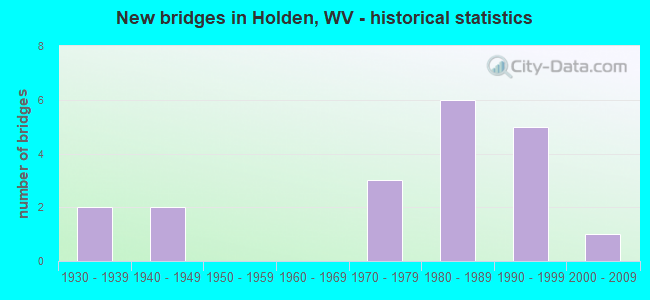
- New bridges - historical statistics
- 21930-1939
- 21940-1949
- 31970-1979
- 61980-1989
- 51990-1999
- 12000-2009


- Bridge Condition - Deck
- 12.5%Good
- 50.0%Satisfactory
- 18.8%Fair
- 18.8%Poor

- Bridge Condition - Superstructure
- 18.8%Good
- 37.5%Satisfactory
- 18.8%Fair
- 25.0%Poor

- Bridge Condition - Substructure
- 12.5%Good
- 50.0%Satisfactory
- 12.5%Fair
- 25.0%Poor

- Bridge Condition - Channel
- 50.0%Good
- 35.7%Satisfactory
- 14.3%Fair
Find on map >> Show street view
Structure Number: 23A028, Location: 0.01 MI South OF C.R.9/38 (Lat: 37.793881, Lng: -82.052989), Route carried "on" structure: County highway 901, Year Built: 1985, Status: Open, Structure Length: 1.44m (4.72ft), Average Daily Traffic: 1,200 (year 2017), Truck Traffic: 6%, Average Future Daily Traffic: 1,584 (year 2037), Design Load: HS 20, Features Intersected: WHITMAN CREEK, Facility Carried by Structure: CR 9/1
Minimum Vertical Clearance: 30+ m (98+ ft), Kilometerpoint: 6.244, Lanes on structure: 2, Owner: State Highway Agency, Approaching Roadway Width: 6.4m (21.0ft), Skew: 4 degrees, Material/Design: Prestressed concrete, Design/Construction: Box Beam or Girders - Multiple, Number Of Spans In Main Unit: 1, Length of Maximum Span: 13.6m (44.6ft), Curb-To-Curb Width: 6.1m (20.0ft), Out-to-Out Width: 6.4m (21.0ft)
Condition: Deck: Satisfactory, Superstructure: Satisfactory, Substructure: Satisfactory, Channel: Satisfactory, Operating Rating: 88.9 metric tons, Method Used To Determine Operating Rating: Load Factor (LF), Inventory Rating: 57.1 metric tons, Method Used To Determine Inventory Rating: Load Factor (LF), Structural Evaluation: Equal to present minimum criteria, Deck Geometry: High priority of replacement, Waterway Adequacy: Better than present minimum criteria, Approach Roadway Alignment: Equal to present minimum criteria, Length Of Structure Improvement: 1.43m (4.69ft), Designated Inspection Frequency: Every 24 months, Inspection Date: Febuary 2020, Bridge Improvement Cost: $154,000, Roadway Improvement Cost: $151,000, Total Project Cost: $341,000 ( Estimate for 2018), Deck Structure Type: Other, Wearing Surface/Protective System: Wearing Surface: Bituminous
Find on map >> Show street view
Structure Number: 23A03, Location: 0.01 MI W OF CO 9/25 (Lat: 37.826700, Lng: -82.078761), Route carried "on" structure: County highway 902, Year Built: 1982, Status: Open, Structure Length: 0.78m (2.56ft), Average Daily Traffic: 1,400 (year 2019), Truck Traffic: 7%, Average Future Daily Traffic: 1,470 (year 2039), Design Load: HS 20, Features Intersected: COPPERAS MINE FORK, Facility Carried by Structure: CR 9/2
Minimum Vertical Clearance: 30+ m (98+ ft), Kilometerpoint: 1.851, Lanes on structure: 2, Owner: State Highway Agency, Approaching Roadway Width: 10.1m (33.1ft), Material/Design: Prestressed concrete, Design/Construction: Box Beam or Girders - Multiple, Number Of Spans In Main Unit: 1, Length of Maximum Span: 6.7m (22.0ft), Curb-To-Curb Width: 5.6m (18.4ft), Out-to-Out Width: 6.1m (20.0ft)
Condition: Deck: Poor, Superstructure: Poor, Substructure: Fair, Channel: Fair, Operating Rating: 62.6 metric tons, Method Used To Determine Operating Rating: Load Factor (LF), Inventory Rating: 37.2 metric tons, Method Used To Determine Inventory Rating: Load Factor (LF), Structural Evaluation: Meets minimum limits, Deck Geometry: High priority of replacement, Waterway Adequacy: Better than present minimum criteria, Approach Roadway Alignment: Equal to present minimum criteria, Length Of Structure Improvement: 0.76m (2.49ft), Designated Inspection Frequency: Every 24 months, Inspection Date: July 2021, Bridge Improvement Cost: $10,000, Roadway Improvement Cost: $2,000, Total Project Cost: $15,000 ( Estimate for 2015), Deck Structure Type: Other, Wearing Surface/Protective System: Wearing Surface: Bituminous
Find on map >> Show street view
Structure Number: 23A031, Location: 1.57 MI WEST OF CR 18 (Lat: 37.827561, Lng: -82.085331), Route carried "on" structure: County highway 902, Year Built: 1989, Status: Open, Structure Length: 1.20m (3.94ft), Average Daily Traffic: 2,100 (year 2019), Truck Traffic: 6%, Average Future Daily Traffic: 2,772 (year 2039), Design Load: HS 25 or greater, Features Intersected: COPPERAS MINE FORK, Facility Carried by Structure: CR 9/2
Minimum Vertical Clearance: 30+ m (98+ ft), Kilometerpoint: 2.527, Lanes on structure: 2, Owner: State Highway Agency, Approaching Roadway Width: 5.2m (17.1ft), Skew: 4 degrees, Material/Design: Prestressed concrete, Design/Construction: Box Beam or Girders - Multiple, Number Of Spans In Main Unit: 1, Length of Maximum Span: 11.6m (38.1ft), Curb or Sidewalk Widths: Left: 0.0m, Right: 0.9m (3.0ft), Curb-To-Curb Width: 6.3m (20.7ft), Out-to-Out Width: 7.4m (24.3ft)
Condition: Deck: Good, Superstructure: Good, Substructure: Satisfactory, Channel: Satisfactory, Operating Rating: 88.9 metric tons, Method Used To Determine Operating Rating: Load Factor (LF), Inventory Rating: 55.3 metric tons, Method Used To Determine Inventory Rating: Load Factor (LF), Structural Evaluation: Equal to present minimum criteria, Deck Geometry: High priority of replacement, Waterway Adequacy: Equal to present minimum criteria, Approach Roadway Alignment: Equal to present minimum criteria, Length Of Structure Improvement: 1.22m (4.00ft), Designated Inspection Frequency: Every 24 months, Inspection Date: October 2020, Bridge Improvement Cost: $90,000, Roadway Improvement Cost: $5,000, Total Project Cost: $100,000 ( Estimate for 2018), Deck Structure Type: Other, Wearing Surface/Protective System: Wearing Surface: Bituminous, Deck Protection: Epoxy Coated Reinforcing
Find on map >> Show street view
Structure Number: 23A032, Location: 1.72 MI WEST OF US 119 (Lat: 37.828881, Lng: -82.087481), Route carried "on" structure: County highway 902, Year Built: 1993, Status: Open, Structure Length: 1.20m (3.94ft), Average Daily Traffic: 2,100 (year 2019), Truck Traffic: 6%, Average Future Daily Traffic: 2,772 (year 2039), Design Load: HS 25 or greater, Features Intersected: COPPERAS MINE FORK, Facility Carried by Structure: CR 9/2
Minimum Vertical Clearance: 30+ m (98+ ft), Kilometerpoint: 2.768, Lanes on structure: 2, Owner: State Highway Agency, Approaching Roadway Width: 5.5m (18.0ft), Skew: 2 degrees, Material/Design: Prestressed concrete, Design/Construction: Box Beam or Girders - Multiple, Number Of Spans In Main Unit: 1, Length of Maximum Span: 11.6m (38.1ft), Curb-To-Curb Width: 7.0m (23.0ft), Out-to-Out Width: 7.3m (24.0ft)
Condition: Deck: Satisfactory, Superstructure: Satisfactory, Substructure: Satisfactory, Channel: Satisfactory, Operating Rating: 88.9 metric tons, Method Used To Determine Operating Rating: Load Factor (LF), Inventory Rating: 58.0 metric tons, Method Used To Determine Inventory Rating: Load Factor (LF), Structural Evaluation: Equal to present minimum criteria, Deck Geometry: High priority of replacement, Waterway Adequacy: Somewhat better than minimum adequacy, Approach Roadway Alignment: Better than present minimum criteria, Length Of Structure Improvement: 1.22m (4.00ft), Designated Inspection Frequency: Every 24 months, Inspection Date: Febuary 2021, Bridge Improvement Cost: $50,000, Roadway Improvement Cost: $15,000, Total Project Cost: $65,000 ( Estimate for 2017), Deck Structure Type: Other, Wearing Surface/Protective System: Wearing Surface: Monolithic Concrete, Deck Protection: Epoxy Coated Reinforcing
Find on map >> Show street view
Structure Number: 23A033, Location: 0.14 MI EAST OF US 119 (Lat: 37.831750, Lng: -82.042350), Route carried "on" structure: County highway 903, Year Built: 1939, Status: Posted for load, Structure Length: 1.29m (4.23ft), Average Daily Traffic: 1,100 (year 2018), Truck Traffic: 6%, Average Future Daily Traffic: 1,440 (year 2038), Features Intersected: ALDRICH CREEK, Facility Carried by Structure: CR 9/3
Minimum Vertical Clearance: 30+ m (98+ ft), Kilometerpoint: 0.225, Lanes on structure: 2, Owner: State Highway Agency, Approaching Roadway Width: 7.3m (24.0ft), Material/Design: Concrete, Design/Construction: Tee Beam, Number Of Spans In Main Unit: 1, Length of Maximum Span: 12.5m (41.0ft), Curb or Sidewalk Widths: Left: 0.1m (0.3ft), Right: 0.1m (0.3ft), Curb-To-Curb Width: 7.3m (24.0ft), Out-to-Out Width: 8.0m (26.2ft)
Condition: Deck: Poor, Superstructure: Poor, Substructure: Poor, Channel: Good, Operating Rating: 37.2 metric tons, Method Used To Determine Operating Rating: Field evaluation and documented engineering judgment, Inventory Rating: 15.4 metric tons, Method Used To Determine Inventory Rating: Field evaluation and documented engineering judgment, Structural Evaluation: Meets minimum limits, Deck Geometry: Meets minimum limits, Waterway Adequacy: Better than present minimum criteria, Approach Roadway Alignment: Equal to present minimum criteria, Bridge Posting: Required (Relationship of Operating Rating to Maximum Legal Load: 0.1 - 9.9% below), Length Of Structure Improvement: 1.37m (4.49ft), Designated Inspection Frequency: Every 24 months, Inspection Date: August 2020, Bridge Improvement Cost: $113,000, Roadway Improvement Cost: $25,000, Total Project Cost: $169,000 ( Estimate for 2018), Deck Structure Type: Concrete Cast-file-Place, Wearing Surface/Protective System: Wearing Surface: Monolithic Concrete
Find on map >> Show street view
Structure Number: 23A037, Location: 0.01 MI SOUTH OF CR 18 (Lat: 37.829761, Lng: -82.044169), Route carried "on" structure: County highway 11932, Year Built: 1991, Status: Open, Structure Length: 1.59m (5.22ft), Average Daily Traffic: 150 (year 2019), Truck Traffic: 6%, Average Future Daily Traffic: 198 (year 2039), Design Load: HS 25 or greater, Features Intersected: COPPERAS MINE FORK, Facility Carried by Structure: CR 119/32
Minimum Vertical Clearance: 30+ m (98+ ft), Kilometerpoint: 0.225, Lanes on structure: 2, Owner: State Highway Agency, Approaching Roadway Width: 3.4m (11.2ft), Material/Design: Wood or Timber, Design/Construction: Stringer/Multi-beam, Number Of Spans In Main Unit: 1, Length of Maximum Span: 15.5m (50.9ft), Curb or Sidewalk Widths: Left: 0.3m (1.0ft), Right: 0.3m (1.0ft), Curb-To-Curb Width: 6.9m (22.6ft), Out-to-Out Width: 7.5m (24.6ft)
Condition: Deck: Fair, Superstructure: Fair, Substructure: Good, Channel: Good, Operating Rating: 49.9 metric tons, Method Used To Determine Operating Rating: Field evaluation and documented engineering judgment, Inventory Rating: 31.7 metric tons, Method Used To Determine Inventory Rating: Field evaluation and documented engineering judgment, Structural Evaluation: Somewhat better than minimum adequacy, Deck Geometry: Meets minimum limits, Waterway Adequacy: Somewhat better than minimum adequacy, Approach Roadway Alignment: Somewhat better than minimum adequacy, Length Of Structure Improvement: 1.59m (5.22ft), Designated Inspection Frequency: Every 24 months, Other Special Inspection Frequency: Every 12 months, Inspection Date: April 2021, Other Special Inspection Date: April 2021, Bridge Improvement Cost: $100,000, Roadway Improvement Cost: $20,000, Total Project Cost: $120,000 ( Estimate for 2018), Deck Structure Type: Wood or Timber, Wearing Surface/Protective System: Wearing Surface: Bituminous
Find on map >> Show street view
Structure Number: 23A083, Location: 0.19 MI SOUTH OF CR 9/2 (Lat: 37.823161, Lng: -82.059311), Route carried "on" structure: County highway 1800, Year Built: 1984, Status: Open, Structure Length: 1.01m (3.31ft), Average Daily Traffic: 1,700 (year 2020), Truck Traffic: 7%, Average Future Daily Traffic: 1,785 (year 2040), Design Load: HS 20, Features Intersected: TRACE FORK, Facility Carried by Structure: CR 18
Minimum Vertical Clearance: 30+ m (98+ ft), Kilometerpoint: 0.917, Lanes on structure: 2, Owner: State Highway Agency, Approaching Roadway Width: 6.1m (20.0ft), Skew: 3 degrees, Material/Design: Prestressed concrete, Design/Construction: Box Beam or Girders - Multiple, Number Of Spans In Main Unit: 1, Length of Maximum Span: 9.6m (31.5ft), Curb or Sidewalk Widths: Left: 1.1m (3.6ft), Right: 0.2m (0.7ft), Curb-To-Curb Width: 8.5m (27.9ft), Out-to-Out Width: 10.1m (33.1ft)
Condition: Deck: Satisfactory, Superstructure: Satisfactory, Substructure: Poor, Channel: Good, Operating Rating: 88.9 metric tons, Method Used To Determine Operating Rating: Load Factor (LF), Inventory Rating: 53.5 metric tons, Method Used To Determine Inventory Rating: Load Factor (LF), Structural Evaluation: Meets minimum limits, Deck Geometry: Somewhat better than minimum adequacy, Waterway Adequacy: Equal to present minimum criteria, Approach Roadway Alignment: Meets minimum limits, Length Of Structure Improvement: 0.85m (2.79ft), Designated Inspection Frequency: Every 24 months, Inspection Date: August 2021, Bridge Improvement Cost: $46,000, Roadway Improvement Cost: $10,000, Total Project Cost: $68,000 ( Estimate for 2015), Deck Structure Type: Other, Wearing Surface/Protective System: Wearing Surface: Bituminous
Find on map >> Show street view
Structure Number: 23A084, Location: 0.02 MI SOUTH OF CR 9/2 (Lat: 37.824919, Lng: -82.060081), Route carried "on" structure: County highway 1800, Year Built: 1977, Year Reconstructed: 1992, Status: Open, Structure Length: 1.57m (5.15ft), Average Daily Traffic: 2,000 (year 2018), Truck Traffic: 6%, Average Future Daily Traffic: 2,640 (year 2038), Design Load: HS 25 or greater, Features Intersected: COPPERAS MINE FORK, Facility Carried by Structure: CR 18
Minimum Vertical Clearance: 30+ m (98+ ft), Kilometerpoint: 1.191, Lanes on structure: 2, Owner: State Highway Agency, Approaching Roadway Width: 8.5m (27.9ft), Material/Design: Prestressed concrete, Design/Construction: Box Beam or Girders - Multiple, Number Of Spans In Main Unit: 1, Length of Maximum Span: 15.2m (49.9ft), Curb or Sidewalk Widths: Left: 1.5m (4.9ft), Right: 0.0m, Curb-To-Curb Width: 8.7m (28.5ft), Out-to-Out Width: 9.2m (30.2ft)
Condition: Deck: Satisfactory, Superstructure: Good, Substructure: Fair, Channel: Good, Operating Rating: 88.9 metric tons, Method Used To Determine Operating Rating: Load Factor (LF), Inventory Rating: 73.5 metric tons, Method Used To Determine Inventory Rating: Load Factor (LF), Structural Evaluation: Somewhat better than minimum adequacy, Deck Geometry: Somewhat better than minimum adequacy, Waterway Adequacy: Equal to present minimum criteria, Approach Roadway Alignment: Equal to present minimum criteria, Designated Inspection Frequency: Every 24 months, Inspection Date: March 2020, Deck Structure Type: Other, Wearing Surface/Protective System: Wearing Surface: Monolithic Concrete, Deck Protection: Epoxy Coated Reinforcing
Find on map >> Show street view
Structure Number: 23A164, Location: 2.34 MI WEST OF CR 18 (Lat: 37.829511, Lng: -82.097700), Route carried "on" structure: County highway 902, Year Built: 1989, Status: Open, Structure Length: 1.20m (3.94ft), Average Daily Traffic: 1,100 (year 2016), Truck Traffic: 6%, Average Future Daily Traffic: 1,452 (year 2038), Design Load: HS 20, Features Intersected: COPPERAS MINE FORK, Facility Carried by Structure: CR 9/2
Minimum Vertical Clearance: 30+ m (98+ ft), Kilometerpoint: 3.766, Lanes on structure: 2, Owner: State Highway Agency, Approaching Roadway Width: 7.0m (23.0ft), Skew: 2 degrees, Material/Design: Prestressed concrete, Design/Construction: Box Beam or Girders - Multiple, Number Of Spans In Main Unit: 1, Length of Maximum Span: 11.6m (38.1ft), Curb-To-Curb Width: 7.0m (23.0ft), Out-to-Out Width: 7.4m (24.3ft)
Condition: Deck: Satisfactory, Superstructure: Satisfactory, Substructure: Satisfactory, Channel: Satisfactory, Operating Rating: 71.7 metric tons, Method Used To Determine Operating Rating: Field evaluation and documented engineering judgment, Inventory Rating: 32.7 metric tons, Method Used To Determine Inventory Rating: Field evaluation and documented engineering judgment, Structural Evaluation: Equal to present minimum criteria, Deck Geometry: High priority of corrective action, Waterway Adequacy: Better than present minimum criteria, Approach Roadway Alignment: Equal to present minimum criteria, Designated Inspection Frequency: Every 24 months, Inspection Date: September 2020, Deck Structure Type: Other, Wearing Surface/Protective System: Wearing Surface: Monolithic Concrete
Find on map >> Show street view
Structure Number: 23A202, Location: 2.05 MI.S.OF CR 9/6 (Lat: 37.785139, Lng: -82.054681), Route carried "on" structure: County highway 901, Year Built: 1987, Status: Open, Structure Length: 0.96m (3.15ft), Average Daily Traffic: 300 (year 2019), Truck Traffic: 6%, Average Future Daily Traffic: 315 (year 2039), Design Load: HS 20, Features Intersected: WHITMAN CREEK, Facility Carried by Structure: CR 9/1
Minimum Vertical Clearance: 30+ m (98+ ft), Kilometerpoint: 7.290, Lanes on structure: 2, Owner: State Highway Agency, Approaching Roadway Width: 6.7m (22.0ft), Skew: 4 degrees, Material/Design: Prestressed concrete, Design/Construction: Box Beam or Girders - Multiple, Number Of Spans In Main Unit: 1, Length of Maximum Span: 9.1m (29.9ft), Curb-To-Curb Width: 6.1m (20.0ft), Out-to-Out Width: 6.5m (21.3ft)
Condition: Deck: Poor, Superstructure: Poor, Substructure: Poor, Channel: Fair, Operating Rating: 51.7 metric tons, Method Used To Determine Operating Rating: Load Factor (LF), Inventory Rating: 30.8 metric tons, Method Used To Determine Inventory Rating: Load Factor (LF), Structural Evaluation: Meets minimum limits, Deck Geometry: Meets minimum limits, Waterway Adequacy: Somewhat better than minimum adequacy, Approach Roadway Alignment: Somewhat better than minimum adequacy, Length Of Structure Improvement: 1.59m (5.22ft), Designated Inspection Frequency: Every 24 months, Other Special Inspection Frequency: Every 12 months, Inspection Date: June 2021, Other Special Inspection Date: June 2021, Bridge Improvement Cost: $265,000, Roadway Improvement Cost: $260,000, Total Project Cost: $577,000 ( Estimate for 2015), Deck Structure Type: Other, Wearing Surface/Protective System: Wearing Surface: Bituminous
Find on map >> Show street view
Structure Number: 23A225, Location: 0.01 MI. W. OF CO 18 (Lat: 37.819700, Lng: -82.061100), Route carried "on" structure: County highway 11965, Year Built: 1996, Status: Open, Structure Length: 1.02m (3.35ft), Average Daily Traffic: 60 (year 2016), Average Future Daily Traffic: 79 (year 2036), Design Load: HS 25 or greater, Features Intersected: TRACE FORK, Facility Carried by Structure: CR 119/65
Minimum Vertical Clearance: 30+ m (98+ ft), Kilometerpoint: 0.016, Lanes on structure: 2, Owner: State Highway Agency, Approaching Roadway Width: 7.6m (24.9ft), Material/Design: Prestressed concrete, Design/Construction: Box Beam or Girders - Multiple, Number Of Spans In Main Unit: 1, Length of Maximum Span: 9.8m (32.2ft), Curb-To-Curb Width: 7.1m (23.3ft), Out-to-Out Width: 7.3m (24.0ft)
Condition: Deck: Good, Superstructure: Good, Substructure: Good, Channel: Good, Operating Rating: 76.2 metric tons, Method Used To Determine Operating Rating: Load Factor (LF), Inventory Rating: 45.4 metric tons, Method Used To Determine Inventory Rating: Load Factor (LF), Structural Evaluation: Better than present minimum criteria, Deck Geometry: Somewhat better than minimum adequacy, Waterway Adequacy: Better than present minimum criteria, Approach Roadway Alignment: Better than present minimum criteria, Designated Inspection Frequency: Every 48 months, Inspection Date: March 2018, Deck Structure Type: Other, Wearing Surface/Protective System: Wearing Surface: Monolithic Concrete, Deck Protection: Epoxy Coated Reinforcing
Find on map >> Show street view
Structure Number: 23A231, Location: 0.08 MI EAST OF US 119 (Lat: 37.825281, Lng: -82.053850), Route carried "on" structure: County highway 70141, Year Built: 1938, Status: Posted for load, Structure Length: 1.26m (4.13ft), Average Daily Traffic: 10 (year 2019), Truck Traffic: 6%, Average Future Daily Traffic: 13 (year 2039), Features Intersected: COPPERAS MINE FORK, Facility Carried by Structure: CR 701/41
Minimum Vertical Clearance: 30+ m (98+ ft), Kilometerpoint: 0.129, Lanes on structure: 2, Owner: State Highway Agency, Approaching Roadway Width: 4.9m (16.1ft), Skew: 2 degrees, Material/Design: Steel, Design/Construction: Stringer/Multi-beam, Number Of Spans In Main Unit: 1, Length of Maximum Span: 12.1m (39.7ft), Curb or Sidewalk Widths: Left: 0.4m (1.3ft), Right: 0.4m (1.3ft), Curb-To-Curb Width: 6.2m (20.3ft), Out-to-Out Width: 7.0m (23.0ft)
Condition: Deck: Fair, Superstructure: Fair, Substructure: Satisfactory, Channel: Satisfactory, Operating Rating: 56.2 metric tons, Method Used To Determine Operating Rating: Load Factor (LF), Inventory Rating: 33.6 metric tons, Method Used To Determine Inventory Rating: Load Factor (LF), Structural Evaluation: Somewhat better than minimum adequacy, Deck Geometry: Somewhat better than minimum adequacy, Waterway Adequacy: Better than present minimum criteria, Approach Roadway Alignment: Equal to present minimum criteria, Bridge Posting: Required (Relationship of Operating Rating to Maximum Legal Load: 10.0 - 19.9% below), Length Of Structure Improvement: 1.52m (4.99ft), Designated Inspection Frequency: Every 24 months, Inspection Date: May 2021, Bridge Improvement Cost: $120,000, Roadway Improvement Cost: $50,000, Total Project Cost: $220,000 ( Estimate for 2017), Deck Structure Type: Concrete Cast-file-Place, Wearing Surface/Protective System: Wearing Surface: Monolithic Concrete
Find on map >> Show street view
Structure Number: 23A248, Location: 0.11 MILE WEST OF US 119 (Lat: 37.799550, Lng: -82.096331), Route carried "on" structure: County highway 11996, Year Built: 1946, Status: Open, Structure Length: 2.07m (6.79ft), Average Daily Traffic: 10 (year 2018), Truck Traffic: 6%, Average Future Daily Traffic: 13 (year 2038), Features Intersected: CSX RAILROAD & TRACE CK, Facility Carried by Structure: CR 119/96
Minimum Vertical Clearance: 30+ m (98+ ft), Kilometerpoint: 0.177, Lanes on structure: 2, Owner: State Highway Agency, Approaching Roadway Width: 6.7m (22.0ft), Material/Design: Steel, Design/Construction: Stringer/Multi-beam, Number Of Spans In Main Unit: 1, Length of Maximum Span: 20.0m (65.6ft), Curb-To-Curb Width: 6.9m (22.6ft), Out-to-Out Width: 7.3m (24.0ft)
Condition: Deck: Satisfactory, Superstructure: Satisfactory, Substructure: Satisfactory, Operating Rating: 88.9 metric tons, Method Used To Determine Operating Rating: Load Factor (LF), Inventory Rating: 88.9 metric tons, Method Used To Determine Inventory Rating: Load Factor (LF), Structural Evaluation: Equal to present minimum criteria, Deck Geometry: Somewhat better than minimum adequacy, Underclear: High priority of replacement, Approach Roadway Alignment: Equal to present minimum criteria, Length Of Structure Improvement: 2.07m (6.79ft), Designated Inspection Frequency: Every 24 months, Inspection Date: December 2020, Bridge Improvement Cost: $750,000, Roadway Improvement Cost: $75,000, Total Project Cost: $825,000 ( Estimate for 2017), Deck Structure Type: Other, Wearing Surface/Protective System: Wearing Surface: Integral Concrete
Find on map >> Show street view
Structure Number: 23A256, Location: 0.26 MILE SOUTH OF CR 18 (Lat: 37.824711, Lng: -82.056911), Route carried "on" structure: US 11900, Year Built: 1997, Status: Open, Structure Length: 37.44m (122.83ft), Average Daily Traffic: 6,745 (year 2019), Truck Traffic: 8%, Average Future Daily Traffic: 7,082 (year 2039), Design Load: HS 25 or greater, Features Intersected: CO 18 AND CO 701/41, Facility Carried by Structure: US 119
Minimum Vertical Clearance: 30+ m (98+ ft), Kilometerpoint: 5.246, Lanes on structure: 4, Lanes under structure: 2, Base Highway Network: Yes, Owner: State Highway Agency, Approaching Roadway Width: 12.2m (40.0ft), Skew: 31 degrees, Material/Design: Prestressed concrete continuous, Design/Construction: Stringer/Multi-beam, Number Of Spans In Main Unit: 3, Number Of Approach Spans: 4, Length of Maximum Span: 67.1m (220.1ft), Curb-To-Curb Width: 25.1m (82.3ft), Out-to-Out Width: 26.1m (85.6ft)
Condition: Deck: Satisfactory, Superstructure: Fair, Substructure: Satisfactory, Channel: Good, Operating Rating: 88.9 metric tons, Method Used To Determine Operating Rating: Field evaluation and documented engineering judgment, Inventory Rating: 40.8 metric tons, Method Used To Determine Inventory Rating: Field evaluation and documented engineering judgment, Structural Evaluation: Somewhat better than minimum adequacy, Deck Geometry: Superior to present desirable criteria, Underclear: Superior to present desirable criteria, Waterway Adequacy: Superior to present desirable criteria, Approach Roadway Alignment: Equal to present desirable criteria, Designated Inspection Frequency: Every 24 months, Other Special Inspection Frequency: Every 12 months, Inspection Date: June 2020, Other Special Inspection Date: June 2021, Deck Structure Type: Concrete Cast-file-Place, Wearing Surface/Protective System: Wearing Surface: Monolithic Concrete, Deck Protection: Epoxy Coated Reinforcing
Find on map >> Show street view
Structure Number: 23A34, Location: 0.01 MILES EAST OF C R 18 (Lat: 37.827939, Lng: -82.047831), Route carried "on" structure: County highway 11934, Year Built: 2009, Status: Open, Structure Length: 1.51m (4.95ft), Average Daily Traffic: 300 (year 2017), Truck Traffic: 4%, Average Future Daily Traffic: 366 (year 2037), Design Load: HL 93, Features Intersected: COPPERAS MINE FORK, Facility Carried by Structure: C R 119/34
Minimum Vertical Clearance: 30+ m (98+ ft), Kilometerpoint: 0.016, Lanes on structure: 2, Owner: State Highway Agency, Approaching Roadway Width: 8.2m (26.9ft), Material/Design: Prestressed concrete, Design/Construction: Box Beam or Girders - Multiple, Number Of Spans In Main Unit: 1, Length of Maximum Span: 14.6m (47.9ft), Curb-To-Curb Width: 7.9m (25.9ft), Out-to-Out Width: 8.4m (27.6ft)
Condition: Deck: Satisfactory, Superstructure: Satisfactory, Substructure: Satisfactory, Channel: Good, Operating Rating: 66.2 metric tons, Method Used To Determine Operating Rating: Load and Resistance Factor (LRFR), Inventory Rating: 50.8 metric tons, Method Used To Determine Inventory Rating: Load and Resistance Factor (LRFR), Structural Evaluation: Equal to present minimum criteria, Deck Geometry: Somewhat better than minimum adequacy, Waterway Adequacy: Better than present minimum criteria, Approach Roadway Alignment: Equal to present minimum criteria, Designated Inspection Frequency: Every 48 months, Inspection Date: July 2019, Deck Structure Type: Other, Wearing Surface/Protective System: Wearing Surface: Bituminous, Deck Protection: Epoxy Coated Reinforcing
Find on map >> Show street view
Structure Number: 30A134, Location: 0.12 MI WEST OF CR 65/30 (Lat: 37.796600, Lng: -82.108489), Route carried "on" structure: US 11900, Year Built: 1970, Status: Open, Structure Length: 16.83m (55.22ft), Average Daily Traffic: 6,700 (year 2020), Truck Traffic: 8%, Average Future Daily Traffic: 8,174 (year 2040), Design Load: HS 20, Features Intersected: CSX RAILROAD, Facility Carried by Structure: US 119
Minimum Vertical Clearance: 30+ m (98+ ft), Kilometerpoint: 33.265, Lanes on structure: 4, Base Highway Network: Yes, Owner: State Highway Agency, Approaching Roadway Width: 33.5m (109.9ft), Skew: 20 degrees, Material/Design: Steel, Design/Construction: Stringer/Multi-beam, Number Of Spans In Main Unit: 5, Length of Maximum Span: 33.5m (109.9ft), Curb-To-Curb Width: 27.0m (88.6ft), Out-to-Out Width: 28.2m (92.5ft)
Condition: Deck: Fair, Superstructure: Poor, Substructure: Poor, Operating Rating: 88.9 metric tons, Method Used To Determine Operating Rating: Load Factor (LF), Inventory Rating: 58.0 metric tons, Method Used To Determine Inventory Rating: Load Factor (LF), Structural Evaluation: Meets minimum limits, Deck Geometry: Superior to present desirable criteria, Underclear: Somewhat better than minimum adequacy, Approach Roadway Alignment: Better than present minimum criteria, Length Of Structure Improvement: 16.83m (55.22ft), Designated Inspection Frequency: Every 24 months, Other Special Inspection Frequency: Every 12 months, Inspection Date: December 2021, Other Special Inspection Date: December 2021, Bridge Improvement Cost: $715,000, Roadway Improvement Cost: $12,000, Total Project Cost: $750,000 ( Estimate for 2017), Deck Structure Type: Concrete Cast-file-Place, Wearing Surface/Protective System: Wearing Surface: Latex Concrete
Find on map >> Show street view
Structure Number: 23A218, Location: 5.60 MI WEST OF WV 44 (Lat: 37.754219, Lng: -82.082511), Route carried "under" structure: County highway 11905, Year Built: 1975, Structure Length: 0. m, Average Daily Traffic: 10 (year 2018), Truck Traffic: 6%, Features Intersected: COUNTY ROUTE 119/5, Facility Carried by Structure: COAL CONVEYOR BELT
Minimum Vertical Clearance: 7.62m (25.00ft), Kilometerpoint: 9.012, Lanes under structure: 2, Length of Maximum Span: 45.7m (149.9ft)
Find on map >> Show street view
Structure Number: 23A256, Location: 0.26 MILE SOUTH OF CR 18 (Lat: 37.825100, Lng: -82.056431), Route carried "under" structure: County highway 1800, Year Built: 1997, Structure Length: 0. m, Average Daily Traffic: 3,100 (year 0007), Truck Traffic: 6%, Features Intersected: CO 18 AND CO 701/41, Facility Carried by Structure: US 119
Minimum Vertical Clearance: 29.87m (98.00ft), Kilometerpoint: 1.770, Lanes on structure: 4, Lanes under structure: 2, Length of Maximum Span: 67.1m (220.1ft)
Find on map >> Show street view
Structure Number: 30A119, Location: 0.04 MI EAST OF US 119 (Lat: 37.790211, Lng: -82.122619), Route carried "under" structure: County highway 703, Year Built: 1948, Structure Length: 0. m, Average Daily Traffic: 20 (year 2010), Features Intersected: COUNTY ROUTE 7/3, Facility Carried by Structure: CSX RAILROAD
Minimum Vertical Clearance: 2.90m (9.51ft), Kilometerpoint: 0.064, Lanes under structure: 1, Length of Maximum Span: 3.7m (12.1ft)